 Airbus UP42 startup democratizes access to geospatial data. It launches an open platform and marketplace dedicated to helping developers and startups build, run, and scale geospatial products. It opens up access to geospatial data, imagery, and processing algorithms — allowing users to develop and launch innovative products. On this landmark occasion, we engaged into a conversation with CPO of UP42, Sean Wiid to know more about the journey, the offerings and much more.
Access to quality geospatial data has always been an issue, how will UP42 solve this?
It’s not just accessing quality geospatial data that is hard. Knowing how to develop, train, and run algorithms to extract insights from the data as well as building the machinery to do this at scale is also challenging.
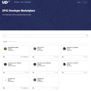
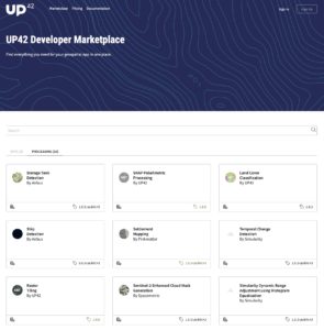
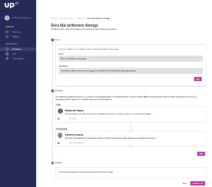
UP42 aims to solve all 3 of these problems. Firstly, our partners publish reusable “blocks” in our marketplace. Users then create geospatial processing workflows by selecting combinations of data and processing blocks, either via our UI or through code. Finally, users can run workflows by simply selecting their area of interest on a map. Our infrastructure scales-up on demand to fetch the data, run the processing and deliver the results. In this way, anybody can derive insights from commercial and open geospatial data, at both small and large scale. By bringing together different data sources and algorithms in an accessible and actionable way, we open up access to geospatial data and insights to everyone.
What’s with the intriguing name UP42? What does it stand for?
We get this question a lot! For us, UP42 is a highly symbolic name packed with meaning. The UP refers to the fact that we get a lot of our data from satellites, planes and drones. The number 42 is a nod to The Hitchhiker’s Guide to the Galaxy, where 42 represents the answer to life, the universe and everything. For the more technically minded, * is also Unicode for the wildcard character (*), suggesting the endless possibilities we see with our platform. Taken together, UP42 is providing the answer to everything from above.
UP42 is opening up access to geospatial data that has traditionally been restricted to large corporates and governments.” How is UP42 going to ‘lower the barriers’?
Our philosophy has a focus on usability — enabling and empowering people to explore the planet for themselves. We reach out to data sources and the infrastructure of UP42 integrates algorithms developed by third parties — making our platform easier to use and access. Customers can choose their needs and preferences from the offerings that are available. For comparison, think of UP42 as a traditional factory. There are raw materials going in, and down the line, there is an end product — this is the geospatial insight that they need. UP42’s ability to run processing pipelines using large amounts of remote sensing data and algorithms means that our infrastructure is an easy-to-use, reliable geospatial ecosystem. As a result, we are standardizing the way businesses access geospatial insights. Regardless of industry, technical expertise, or company size, we are lowering the barrier and bringing geospatial data within reach to those that previously couldn’t access it.
How is UP42 going to manage the cost? Is there any reason to worry about the quality?
For UP42: We are an on-demand platform. So we don’t have to worry about the cost of paying for or storing large amounts of data upfront.
For our partners: UP42 is a marketplace. Our main business goal is to make money for our partners by reselling usage of their data and algorithm blocks because we make money off the revenue share.
For our customers: UP42 is an on-demand platform, so customers only pay for what they use and can run jobs on very small areas of interest. This means that companies can keep their costs down upfront. Our pricing is a credit based system where users buy credits and spend them on data and processing blocks as they require. The total price will depend on the particular data or processing block that they are looking to use and the scale of the job they are running. The unit price per block is set by the block provider (not UP42) is the same regardless of organizations size and the only total cost driver is how much of the block is used. We will build in volume mechanisms over time.
Quality: Yes, this is something we take seriously. We don´t worry too much about data quality, because the idea is that the data is passed through directly from the source so there isn´t a quality difference. Where we take care though is on the processing side. Image processing and machine learning algorithms are often built for specific use cases or specific data sets. So we need to guide users to use blocks which are meant to work together to ensure quality results. We do this in two ways: firstly, a strict definition of block capabilities determines which blocks physically can be plugged together, and secondly provide enough detail for each processing block to be sure the user can make an informed decision. Example: we have a machine learning algorithm on the platform from Pinkmatter which has been specially trained to detect settlement expansion in developing countries. Using it over a city in Western Europe is possible, but would not provide useful results. We have to guide our users in the right direction here.
Primarily data from which satellites are to be used for building the applications?
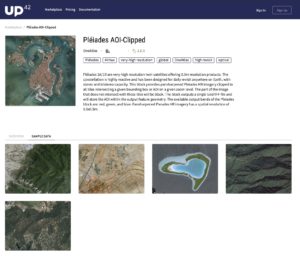
Given that we have been started by Airbus, our initial focus has been on satellite data. We currently support a range of commercial and open satellite data sources including Landsat-8, Sentinel-2, SPOT 6/7, Pleiades 1A/1B, and more.
However, this is only the beginning. Our goal is to include ALL kinds of Geospatial data. We have already integrated DEM data and the first public transportation data block. We are in active discussions with companies providing aerial imagery, drone imagery, building footprints, road networks
We strongly believe that extracting insights from combinations of geospatial datasets is what is really going to be driving innovation in the space. We want to be at the forefront of making that happen.
How much competition is UP42 facing from similar players?
There are of course a range of competitors out there who are doing some amazing things, but we see that they are mostly
- Closed (i.e. data provider trying to find ways to boost their own data sales)
- Government initiative (not commercially focused)
- Focused on selling their own IP and solutions
UP42 has no ulterior motives that introduce bias in our marketplace model. We don’t own data. We don’t build algorithms. We don´t sell geospatial software. Our entire business depends on us making our data and algorithm partners money. We believe that we are the only company providing a truly open two-sided geospatial marketplace, where all data and processing providers can distribute their products and all customers can easily consume these products with very little effort. In fact, you will see more and more of those competitors working with UP42 as well.
How has been the response from the market? Any major client you would like to name?
So far, the response has been very positive. We co-created the product and the partnership model with around 10 companies in the space, including data providers, algorithm specialists and solution builders from both small start-ups and large multi-nationals. These partners have been deeply involved in our product development and as a result we are confident that we are on the right path to addressing some of the biggest pain points in the industry. In addition to our co-creation partners, we have now opened up the platform to a longer list of beta testers. We of course still have lots of work to do, but the feedback so far is encouraging: Ray Richardson, CTO of Simularity, one of our partners, has told us “this is the platform I’ve been looking for since I started working in this industry”.
What’s the projected growth of the start-up?
We are not able to give numbers publically at this stage. Suffice to say that our revenue targets are aggressive and that we expect this to be a profitable business within 3-4 years.
Which all sectors, you think would benefit the most from the services of UP42?
We are focused more on solving the 3 main problems mentioned earlier than the use cases of specific industries right now. So we are seeing interest from literally all sectors and all company sizes. Having said that, we see great potential in infrastructure, agriculture, retail, finance, construction, insurance and environmental monitoring.
From here to where?
We are very proud of how far we have come in such a short time, but are also humbled by how much we still have to do! We are now focusing on broadening the partner ecosystem and diversifying the blocks on the platform, improving the developer experience and expanding opportunities to tap into new data streams, e.g. tasking of satellites across multiple providers. Our mission is to make UP42 the irreplaceable backbone powering geospatial insights at scale in companies all over the world.
What has been the role of Airbus – from ideation to launch to customer acquisition?
UP42 is a wholly owned subsidiary of Airbus Defense and Space. Airbus recognized the need for a neutral marketplace and ecosystem to grow the market and decided that an independent start-up was the best way to achieve this. UP42 was incubated by BCG Digital Ventures with guidance from Airbus, but is now operating independently. We have the best of both worlds: we have the freedom to operate like a start-up, but still get to leverage Airbus for support in multiple domains, including helping us with additional customer acquisition.
Your message to tech start-ups.
For users: We can help you go faster by giving you data, algorithms and scale out of the box. One Agri-tech company we spoke to estimated they would have released their first product 6 months early had UP42 existed when they started building.
For partners: We can provide an additional channel and revenue stream for your data or algorithms, where you stay in control of your IP, marketing and pricing.
Know more about UP42:


