

Geo Sessions is back for a second year! With over 3,000 attendees from 120 countries at last year’s online event, NV5 is hosting Geo Sessions 2025 – a premier online thought leadership event happening September 16-18. This three-day event welcomes over 20 experts from public organizations, academia, and commercial industries to explore the latest trends, benefits, techniques, and applications of geospatial data and analysis. Airbus, USGS, e-GEOS, RIEGL Laser Measurement Systems, and British Geological Survey represent just a few of the organizations that will be speaking. See what the present and future of geospatial data looks like from their perspectives.
Each day features a dedicated 2-hour session focused on one of the three key data modalities:
- Lidar – September 16
- SAR (Synthetic Aperture Radar) – September 17
- Spectral – September 18
Hear what attendees said about last year’s Geo Sessions:
“Awesome presentations, thank you. Please continue with these Sessions. This is the first time I have watched and they have been incredibly interesting.”
– Attendee at UK Government, UK
“While some of the information covered in this series was over my head a bit, this was a great set of sessions. Thank you for sharing these experiences with us. I look forward to upcoming seminars.”
– Attendee at Civil & Environmental Consultants, Inc., USA
“The opportunity to hear from such experienced and diverse professionals in the field at no cost is incredibly valuable. Thank you all for this opportunity.”
– Attendee at FVA, Turkey
“Great idea to have these presentations. With climate change, the impact of transportation infrastructure, and difficulties in getting up-to-date data like aerial imagery (active or passive), I think satellite imagery can help manage the transportation assets’ life cycle.”
– Attendee at the Florida Department of Transportation, USA
Whether you’re already working with geospatial data or just beginning to explore its potential, Geo Sessions offers valuable insights into how lidar, SAR, and spectral data are shaping decision-making and innovation across industries.
The best part – this event is completely FREE to attend.
Check out the line-up of amazing speakers and reserve your spot today!
Not sure if you can attend? Register anyway to receive access to the recordings.
Questions or difficulties registering? Email geosessions@nv5.com.


#Events

Next article
In recent times, foundation models have improved fields of natural language processing and computer vision. Now, they’re improving Earth observation (EO) – assisting researchers, climate scientists, and policy-makers to extract deeper insights from satellite data with minimal supervision. If you’re wondering how to get started with these powerful models, this guide will help you take the first steps and understand what’s possible.
Why Foundation Models Matter for EO?
Foundation Models in Earth observation by Geoawesome
These capabilities make foundation models an excellent starting point for EO workflows. Training large models from scratch or relying on classical remote sensing techniques is no longer necessary!
Step-by-Step Guide to Getting Started
Step 1: Set Up Your Environment
To run most foundation models for EO, you’ll need:
- Python 3.8+ environment
- Jupyter Notebook or Google Colab (Colab is easiest for beginners)
- Basic ML libraries: torch, numpy, matplotlib, transformers, and domain-specific libraries like rasterio or earthengine-api
- GPU access (recommended but not mandatory): Colab provides a free GPU runtime, which speeds up inference
Step 2: Choose Your Foundation Model
Several excellent ready-to-use notebooks showcase how to apply foundation models in EO tasks. Depending on the specific use case, typical tasks include segmentation, classification, time-series embedding, or generation.
Quick Comparison Table
Step 3: Launch a Notebook
Let’s walk through launching and using one of these models: TerraMind.
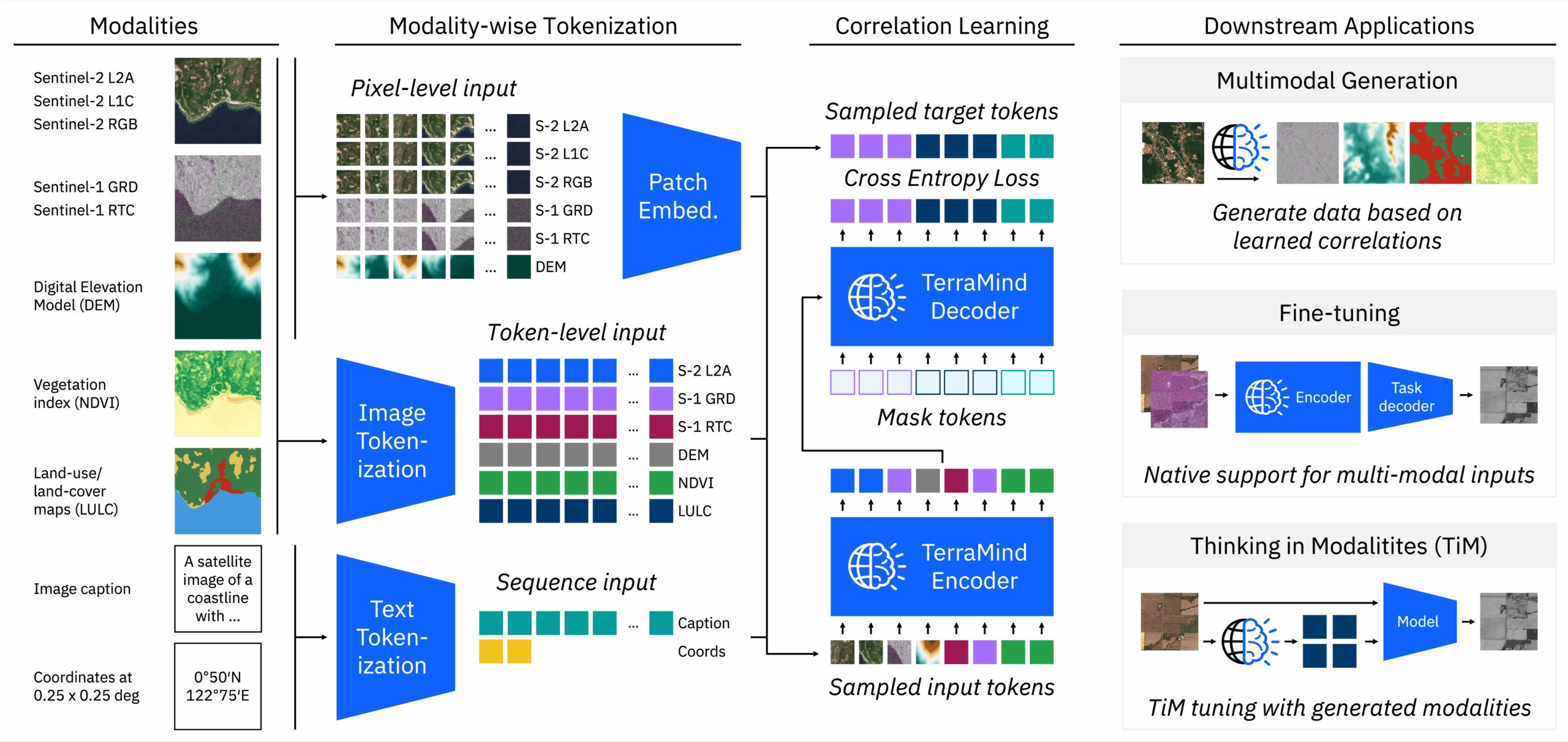
TerraMind was launched as an open-source foundation model on Earth Day (April 22, 2025), in collaboration with IBM, ESA Φ-lab, DLR, and Jülich Supercomputing Centre, marking the first any-to-any multimodal generative model for Earth observation.
- Visit the TerraMind GitHub repository.
- Open the folder notebooks/ and choose a demo notebook like terramind_v1_base_sen1floods11.ipynb.
- Click on “Open in Colab.”
- Change the runtime to GPU: Runtime > Change runtime type > GPU.
- Run each cell step-by-step:
- It will load model weights
- Process Sentinel-1 or Sentinel-2 imagery
- Perform flood segmentation or image generation
Within minutes, you’ll see visualizations of input and output images, showcasing how the model interprets EO data.
TerraMind: model workflow
Step 4: Explore Other Use Cases
Here are highlights of other foundation model notebooks you can try:
- Two core demos: Prithvi-EO (temporal segmentation) and TerraMind (disaster response)
- Run entirely on Colab
- Great for learning about segmentation and transfer learning in EO
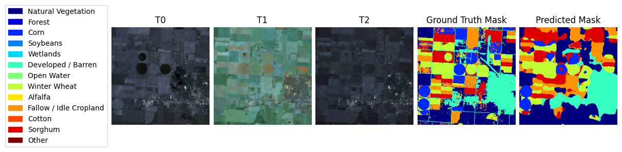
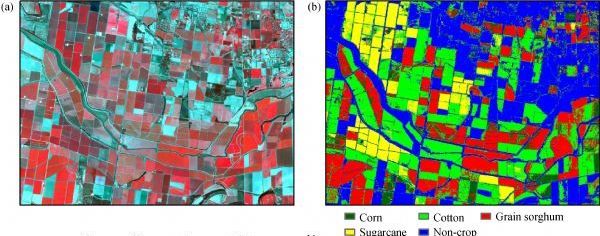
ML4EO: crop classification
- Offers a semantic understanding of EO through embeddings
- Launch via Binder or JupyterLab on your local machine
- Use it to search, cluster, or visualize satellite scenes
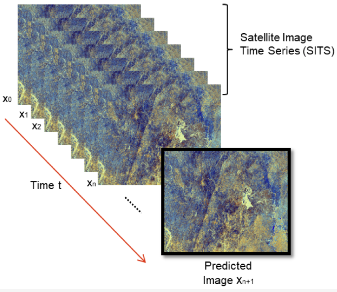
- Time-series embedding model designed for remote sensing
- Uses Sentinel-1, Sentinel-2, and ERA5 inputs
- Built to integrate with Google Earth Engine
- One of the best-organized and most comprehensive model bases for EO available today
- Features an extensive, curated list of ready-to-use models and techniques with a strong emphasis on reproducibility and simplicity
- Categories include:
- Segmentation: land cover, building footprints, water bodies
- Classification: land use, deforestation, urban mapping
- Regression: biomass estimation, crop yield
- Super-resolution and denoising using diffusion models
- Foundation embeddings like EarthPT and contrastive models
- Many models are runnable directly in Colab, requiring minimal setup
- A valuable resource for anyone serious about scaling EO analysis with deep learning
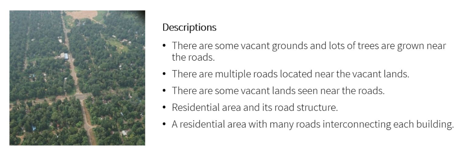
Satellite-image-deep-learning Collection: Image Captioning
Satellite-image-deep-learning Collection: Crop classification
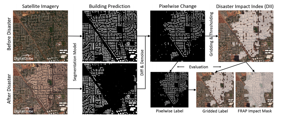
Satellite-image-deep-learning Collection: Disaster response
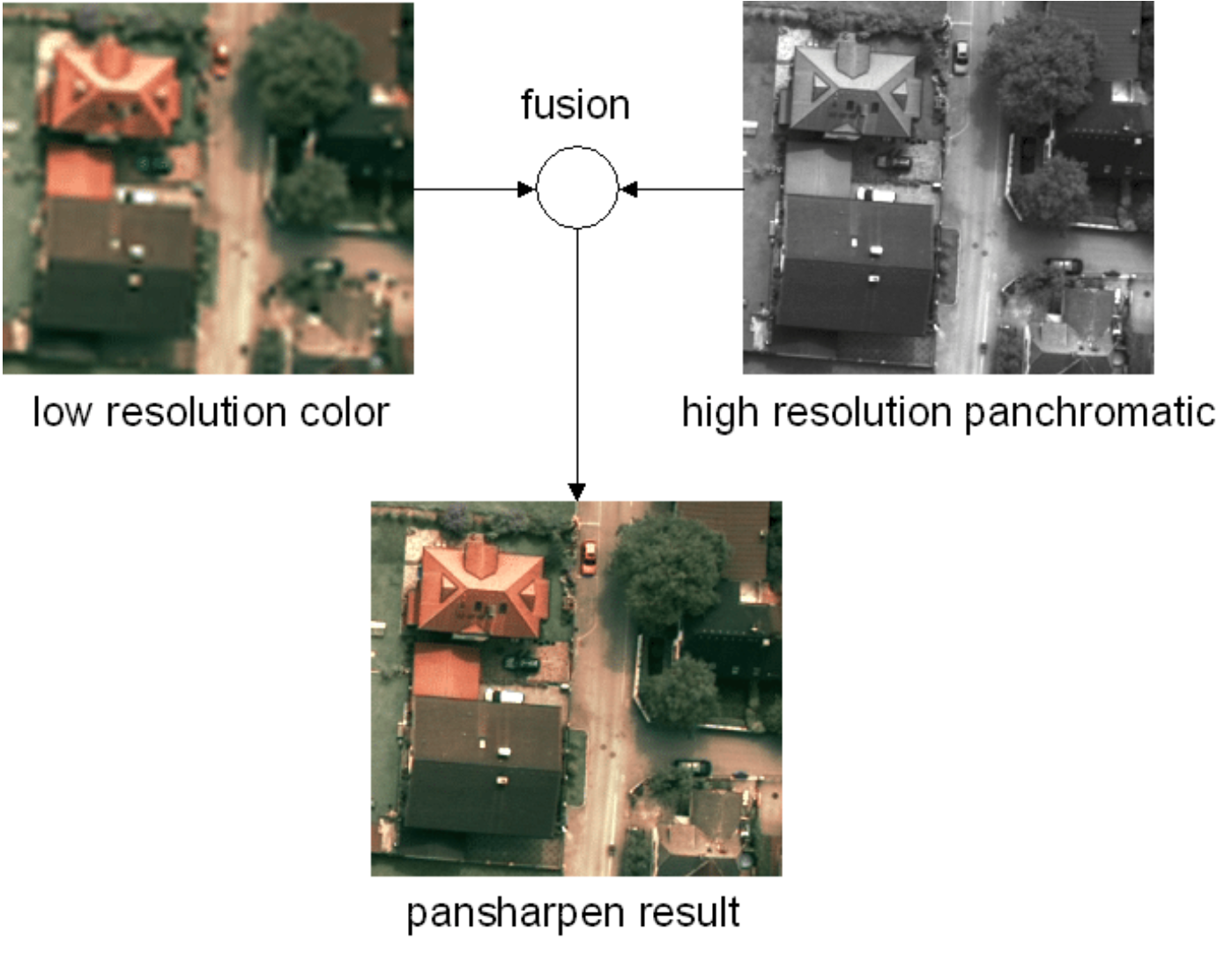
Satellite-image-deep-learning Collection: Pansharpening
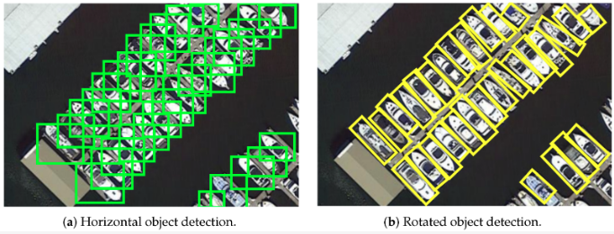
Satellite-image-deep-learning Collection: Object detection
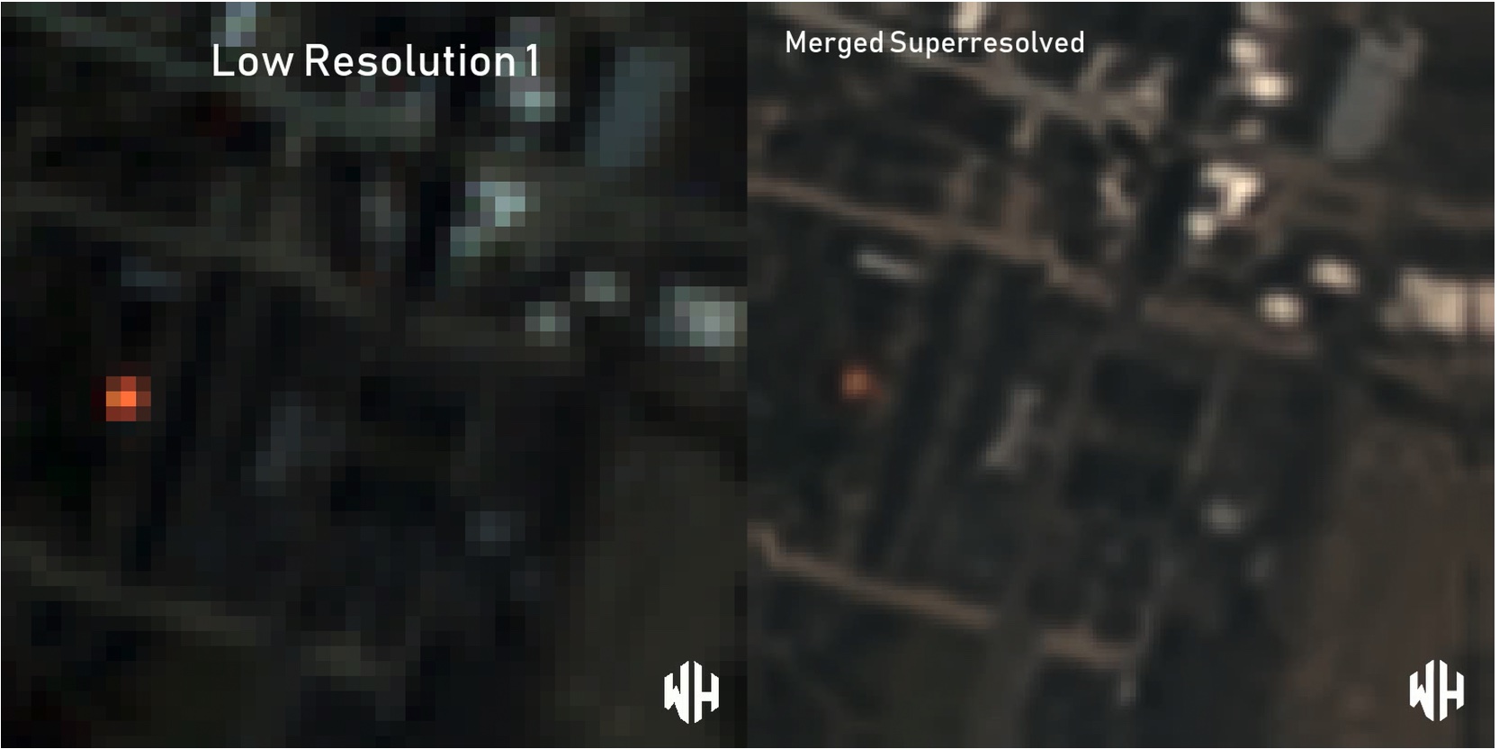
Satellite-image-deep-learning Collection: Super-resolution
Satellite-image-deep-learning Collection: Time-series
Step 5: Customize or Fine-Tune
Once you’re comfortable running the base models:
- Modify inputs: Use your own GeoTIFFs or Sentinel tiles
- Fine-tune: If you have labeled data, adapt the foundation model to your region or problem
- Integrate with pipelines: Use model outputs in QGIS, dashboards, or Python apps
Most foundation models allow flexible configuration and output customization, making them easy to integrate into your own EO workflows.
Real-World Impact
Applications of Foundation Models in Environmental and Disaster Response by Geoawesome
These capabilities make foundation models especially valuable for NGOs, government agencies, and academic labs that may not have the resources to train deep models from scratch.
Summary: Your Starting Path
- Choose the right notebook based on your use case.
- Launch in Colab or Jupyter, enable GPU, and run through examples.
- Experiment with new inputs or tasks.
- Scale or customize to your EO project needs.
The EO field is entering a new era where foundation models offer plug-and-play intelligence. With open-source tools and notebooks readily available, you can join this transformation today—even if you’re not a deep learning expert.
How to Use Foundation Models for EO Without Coding?
Several platforms have already developed initiatives for no-code or low-code EO workflows. Orbify is a cloud-based platform designed for EO application development, offering ready-made templates and apps that often require no coding at all. Similarly, EOfactory.ai by SkyMap Global provides commercial EO tools for flood mapping, crop monitoring, and other use cases, all powered by ML/AI models running behind the scenes. While Descartes Labs takes an API-first approach, it also includes visual dashboards that allow non-programmers to interact with EO analytics and model outputs. Finally, Microsoft Planetary Computer remains largely developer-focused but includes web-based GUIs and has strong potential to evolve into a more accessible, no-code environment for environmental data exploration.
Final Tip: Stay Curious
These tools are designed to empower you. Explore them. Modify them. Break them and rebuild them. The ability to detect, understand, and act on Earth changes is more accessible than ever.
Want to know more? Check out our article on AI foundation models for geospatial and Earth observation: A new era of Earth understanding.
We’d Love to Hear From You!
Have you tried working with foundation models for Earth observation? Did they help transform your workflow or yield unexpected insights?
Tell us about your experience with foundation models – share your workflows, visualizations, or results. Don’t hesitate to reach out and talk with us: sebastian@geoawesome.com
How do you like this article? Read more and subscribe to our monthly newsletter!

