Why 3D Gaussian Splatting Matters for Mapping, Planning, and Simulation

Cities, drones, and mapping teams now capture huge volumes of high-resolution imagery every day. Turning all of that into smooth, interactive 3D scenes is increasingly difficult, while planners, engineers, and surveyors expect fast updates and real-time tools. This demand keeps growing, supported by a geospatial analytics market projected to reach 118 billion USD by 2032 and a wider geospatial solutions market moving toward over 2 trillion USD by 2034.
Traditional 3D reconstruction pipelines struggle to keep up because they are slow to generate and often heavy to render. This gap has created interest in 3D Gaussian Splatting (3DGS), a technique that offers fast, clean, and highly interactive 3D views of real-world places. It is now used across digital twins, drone mapping, and immersive applications.
This article covers what 3D Gaussian Splatting is, why it matters, how it compares to other techniques, and its limitations
How Gaussian Splatting Really Works
Although the name sounds technical, the idea is easy to grasp. Think of a 3D scene built from millions of soft little blobs. Each blob has a position, a color, and a shape. When you blend them all, you get a smooth and detailed representation of the world.
These blobs are called Gaussians. They behave like tiny flexible dots that carry local information about the surface. Instead of stitching triangles like a mesh or training a big AI network like Neural Radiance Field(NeRF), the model builds the world out of overlapping splats.
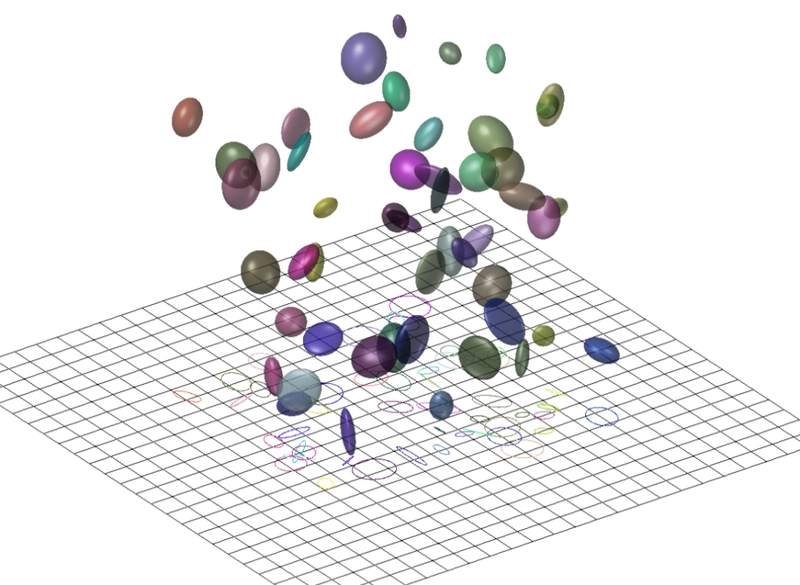
Representation of Gaussians in 3D. Source: Case Studies in Hightopo 3D and Gaussian Splatting
The process begins familiarly. You start with a set of images. Structure from Motion (photogrammetric algorithm) produces a sparse point cloud. Each point becomes the center of one Gaussian (read more here). The system then optimizes the blobs so they match the input photos from every angle. The optimization uses simple techniques like gradient descent, which keeps the pipeline manageable.
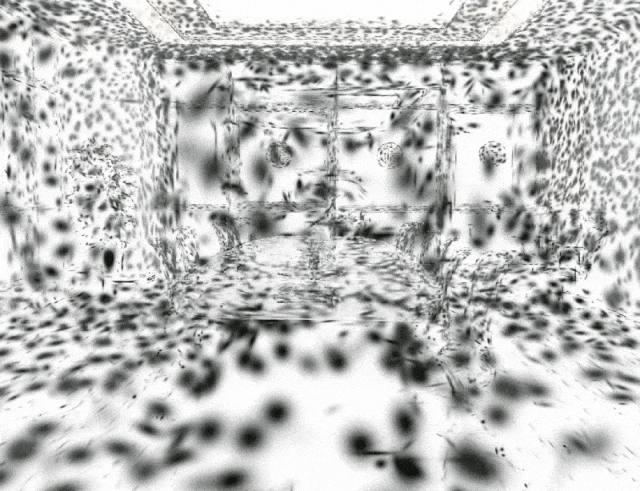
Source: Case Studies in Hightopo 3D and Gaussian Splatting
The real benefit comes from how the scene is rendered. Instead of ray marching through a neural field, 3DGS projects all Gaussians into the camera view and blends them. This technique aligns well with how modern GPUs work. Researchers demonstrated this in efficient rendering studies. The result feels similar to viewing a point cloud, but much smoother and far more photorealistic. Its accuracy is measurable because each splat has a precise 3D position that can be compared with GCPs, photogrammetric point clouds, or LiDAR.
Why It Matters for Geospatial Applications
Gaussian Splatting stands out in geospatial work because it delivers smooth, real-time performance that traditional photogrammetry and NeRF-based methods struggle to match. Since splats are rendered through a GPU-friendly process, navigation feels instant and interactive. This makes it easier to walk through drone surveys, inspect reconstruction outputs, or explore city models without the slowdowns common in older pipelines. Studies on real-time reconstruction highlight how this speed helps VR and planning environments where fluid motion is essential.
Another advantage is its ability to preserve complex or thin structures. Classic mesh algorithms often break on cables, railings, scaffolding, and crane jibs, which leads to missing or distorted geometry. Gaussian Splatting adapts better because it models each part of the scene as a flexible splat that aligns with local details. This results in cleaner and more reliable outputs, especially in industrial or construction settings. Examples from PIX4Dcloud show how splatting preserves elements that photogrammetry often struggles with, which helps inspections, documentation, and QA checks.
The method also fits well with dense drone imagery, which many survey teams already collect. With good overlap, splatting produces stable models quickly, reducing the time between capture and review in construction and planning. Comparisons in this photogrammetry overview show how splatting offers a more interactive viewing experience while still maintaining high fidelity.
Comparison with Existing Techniques
Point-based methods
Point clouds preserve raw measurements but lack smoothness, often causing flicker and noise. Gaussian Splatting extends the idea of point clouds by adding volume and color structure while blending smoothly, producing a cleaner and more stable viewing experience. Several comparisons show the limitations of raw point clouds for visualization.
Mesh reconstruction
Meshes remain essential for GIS analysis, urban modeling, and CAD workflows because they offer explicit surfaces that support measurements and editing. Gaussian Splatting does not replace that. It lacks well-defined geometry, a limitation highlighted in earlier mesh comparisons, so splat-based models are best used for visualization rather than technical operations that require topological accuracy.
Neural Radiance Fields
Neural Radiance Fields (NeRFs) gained attention for generating realistic views from new angles, but they are slow due to the heavy ray-marching process. Gaussian Splatting avoids this by blending splats directly, which makes it far faster and easier to scale. NeRFs may capture subtle lighting effects well, but splatting delivers the performance needed for real-time scenes.
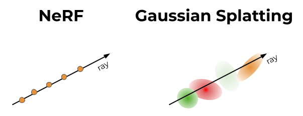
Source: Towards Data Science
In short:
Point clouds are simple but raw.
Meshes are accurate but heavy.
NeRFs are slow but photorealistic.
Gaussian splatting brings speed and clarity, perfect for real-time viewing.
Applications in Terrain and Urban Environments
Gaussian Splatting is already being tested across several geospatial workflows. In drone mapping and infrastructure inspections, it helps preserve thin structures like cables and scaffolding, as shown in PIX4Dcloud examples. City-scale digital twins benefit from their smooth real-time navigation, making it easier to explore dense urban environments. It is also gaining traction in immersive and VR applications, where studies on volumetric video show how splatting enables fluid six-degree-of-freedom movement. Even environmental teams are using it for canopy modeling and MRV workflows, supported by recent forest monitoring research that demonstrates how drones and 3DGS can replace costlier scanning methods.
Challenges and limitations
Despite its strengths, Gaussian Splatting comes with practical challenges that matter for large geospatial projects. One of the main issues is memory. Each splat stores several parameters, and outdoor scenes can contain millions of them. This makes files heavy and puts pressure on GPU memory during training and viewing. GPU memory, often called VRAM, is the dedicated memory on a graphics card used to load and display 3D scenes. When VRAM limits are reached, the model cannot grow in detail, which affects the reconstruction of large urban areas.
Another limitation appears when the input imagery is sparse. Splatting depends on a reliable point cloud from Structure from Motion, so low overlap produces unstable geometry and floating blobs at incorrect depths. These artifacts, described in sparse view research, make scenes look broken. Workarounds like pseudo views and adaptive densification help, but they add complexity and do not fully solve the problem for wide area mapping.
A final challenge is integration with everyday GIS and BIM workflows. Gaussian Splatting is a visualization method, not a geometric one, so it lacks the surfaces and edges needed for spatial analysis, engineering measurements, or editing. Without explicit geometry, standard operations like buffering, line of sight, intersections, or CAD adjustments are hard to perform. The ecosystem is also young. While some platforms like PIX4Dcloud show early integration of splat models, support across mainstream GIS tools is still limited.
Future Directions in the Field
Researchers are exploring ways to scale Gaussian Splatting to larger scenes. One direction is multi-GPU systems that distribute millions of splats across several machines. These setups allow training at higher fidelity than a single GPU system. Another research path introduces semantic guidance, such as PG SAG, which segments buildings or terrain and optimizes them in parallel to improve geometry and reduce memory load.
A second focus aims to make splat models easier to store and stream. Raw files can be large, so several teams work on neural compression that treats splats like structured point clouds and achieves very high reduction ratios. Streaming research also continues to grow, combining tiling, saliency detection, and adaptive quality to send only key parts of a scene over the network, enabling smoother viewing even when bandwidth is limited.
The long-term goal is to bridge the gap between splats and the explicit geometry needed for GIS and BIM tools. Research into extracting surfaces, depth maps, or consistent meshes from splat models is ongoing. If successful, these methods could combine the speed of splatting with the analytical power of structured geometry.
Explore Gaussian Splatting Yourself
Gaussian Splatting is much easier to understand once you see it in motion. A good starting point is the 3DGS demo viewer, where you can rotate and zoom real scenes reconstructed with splats. It shows how the model stays smooth and responsive while you move around the environment.
For short explanations, What is 3D Gaussian Splatting? gives a clear overview of what the method does and where it is used, and 3D Gaussian Splatting! – Computerphile walks through the core idea with simple visuals and examples. If you want to see pure visuals without much theory, you can watch 3D Gaussian Splatting Demo or similar demo clips that show real scenes reconstructed from photos.
If you are ready to try it yourself, the open source Gaussian Splatting repository provides code and sample data so you can run a basic pipeline locally. It is not a one-click tool, but it gives you a practical feel for how images turn into splats and how the resulting model behaves during navigation.
3D Gaussian Splatting offers a new way to explore geospatial datasets. It is fast, detailed, and smooth. It keeps complex structures intact and feels natural in motion. For drone operators, planners, and digital twin teams, it creates a more interactive way to engage with large sites.
It will not replace meshes or point clouds. Those formats remain vital for engineering tasks and spatial analysis. Instead, splatting acts as a high-performance visualization layer. It speeds up decision-making and makes exploration easier. As compression improves, as hybrid workflows develop, and as geometry extraction matures, 3DGS may become a standard part of geospatial toolkits.
For now, it is a promising and practical technique that helps teams move faster while working with real-world imagery.
Did you like this post? Read more and subscribe to our monthly newsletter!


#Contributing Writers


Next article
The U.S. is planning a major ban on DJI, the world’s biggest drone company, set to start on December 23, 2025. This ban, part of a defense bill (NDAA), would stop DJI from bringing any new drones or wireless products into the U.S. after that date. People can still fly the DJI drones they already own, but no new models can be sold. The FCC might even restrict previously approved devices later.
Lawmakers claim this is for national security, fearing DJI’s Chinese ties could lead to spying. However, no public proof of DJI drones spying has been shown. DJI denies these claims, arguing the ban is political, not based on facts, and has asked its American users to speak up.
As the deadline approaches, this article examines how U.S. policy toward DJI evolved and analyzes what the ban means for various stakeholders: the military, law enforcement, commercial industries, hobbyist pilots, and international observers.
Evolution of U.S. Policy Toward DJI
The relationship between the U.S. government and the Chinese-based DJI has been marked by escalating restrictions since 2017, citing concerns over national security and data vulnerabilities. Various U.S. agencies have systematically moved to limit or ban the use of DJI products.
| Year | Milestone |
| 2017 |
The U.S. Army halts all use of DJI drones over cyber concerns.
|
| 2019
|
The Department of Homeland Security (DHS) warns U.S. companies about potential data risks from Chinese-made drones.
|
| 2020
|
The U.S. Department of Commerce adds DJI to its Entity List (a trade “blacklist”), restricting U.S. firms from exporting technology to DJI.
|
| 2020
|
Congress introduces the American Security Drone Act to permanently bar federal agencies from using Chinese-manufactured drone technology.
|
| 2023
|
Congress sets a critical, looming deadline: December 23, 2025, for a formal security audit of DJI. Failure to complete it triggers an automatic punitive clause.
|
| 2024
|
The FCC halts the approval of new DJI equipment models, and U.S. Customs and Border Protection increases enforcement of import restrictions.
|
| 2025 |
As no U.S. agency successfully completes the mandated security audit of DJI, the company is automatically set to be added to the FCC’s Covered List. This action is the functional equivalent of an immediate market ban, prohibiting the authorization, import, and sale of new DJI products in the U.S.
|
With this background, the upcoming ban’s ramifications can be examined from multiple perspectives.
U.S. Military and National Security Perspective
U.S. officials see DJI as a risk, and the December 2025 ban is the final result of those worries. U.S. defense and spy agencies fear China’s government could force DJI to hand over data or use its drones for spying, potentially mapping important sites. FBI and Homeland Security cyber officials warned in early 2024 that Chinese-made drones are a “big risk” to key infrastructure. The U.S. military stopped using DJI equipment back in 2017. Since then, the Pentagon and Congress have actively worked to remove DJI from the defense supply chain to cut down on relying on Chinese technology and boost American drone development.
However, some experts question the ban’s necessity, as no public proof has shown DJI sending data to China. Multiple independent reviews—including a 2020 study by Booz Allen Hamilton and a 2021 Pentagon report—found no sign of harmful code or secret data transfer. DJI highlights its “Local Data Mode” and that it stopped all automatic log syncing for U.S. users since 2024. Despite this, the ban is mostly welcomed by the U.S. security establishment as a careful step, sending a strong message and fixing a possible weakness in America’s technology.
U.S. Law Enforcement and Public Safety Agencies
A ban on DJI drones would be bad news for American police, fire, and other public safety groups. While agreeing with the national security reason, DJI drones are essential tools for their daily work, and good, cheap replacements are hard to find.
This was proven by Florida’s 2023 state ban on Chinese drones, which forced agencies to ground hundreds of DJI units. First responders reported “huge failures” with the approved American-made replacements. Orlando Police Sergeant David Cruz reported five drone losses with U.S. models in 18 months, compared to zero with DJI over five years. Other witnesses noted that U.S.-made drones “cannot fly at night,” ending key night search-and-rescue work. The cost to replace DJI drones is huge—Florida estimated $200 million, and American alternatives cost “8 to 14 times more.” Many smaller departments cannot afford replacements, leading to sharply reduced drone operations.
Federal lawmakers are aware of these issues, leading to plans for a grant program to help first responders switch and a recognition that police and fire services need reliable alternatives. Now that the ban is near, public safety leaders are scrambling, often having to do less aerial work or hope new American drones can meet the challenge.
Impact on the Commercial Drone Sector
The likely ban on DJI is causing worry in the U.S. business world—from farming and building to movie-making. American companies widely use DJI drones because of their quality and low cost. No U.S. or European company currently matches DJI’s product range. Lawmakers like Senator John Boozman admit, “They are the main drone maker in the United States at a fair price.”
One reason for the ban is to help the U.S. drone industry grow by removing its biggest rival. This protective action could encourage U.S. drone startups and help companies like France’s Parrot or America’s Skydio scale up. The U.S. government already supports programs like the Pentagon’s “Blue UAS” list and the new “Green UAS” approval for secure business drones. However, as of 2025, no rival company can match DJI’s production scale or advanced technology for businesses.
Simply put, a DJI ban means things will cost more and U.S. businesses that use drones might slow down. Companies face higher costs for non-DJI drones and staff retraining. A secret 2021 government paper stated that forcing a switch to U.S.-made drones would reduce capability by over 80% in some cases while making costs much higher. On the other hand, American drone makers see a chance to succeed. For now, the business world will face a tough change, as no business group has more money at risk than the commercial drone sector.
The intense development of small, affordable drones for military use, spurred by the war in Ukraine, could introduce a new wave of competitors. Defence companies and startups rapidly innovating in this high-pressure environment may soon adapt their technology for commercial applications. These new players, focused on secure, resilient, and cutting-edge drone hardware and software, could quickly enter and disrupt the commercial market, particularly as they seek to scale up production and diversify their customer base beyond the military.
Effects on Hobbyist Drone Pilots
For U.S. drone pilots who fly for fun, the ban is causing worry and annoyance. DJI controls almost 90% of the consumer drone market in North America. The ban means that after December 2025, you won’t be able to buy new DJI models in the U.S., stopping the flow of new products. Pilots can still fly their existing DJI drones, but replacing them or finding spare parts will become harder.
Many hobbyists worry that other brands won’t be as good, lacking DJI’s blend of easy use, quality camera, and advanced features at a good price. DJI itself is asking American users to speak up to lawmakers. On the positive side, stores saw a rush of DJI drones available in late 2025, leading to big discounts. Also, the ban doesn’t make flying older DJI drones illegal. Hobbyist groups may turn to buying used drones or building custom ones. Other drone companies like Skydio (U.S.) and Parrot (France) might start focusing more on regular buyers. Still, American hobbyists face fewer choices and are disappointed that politics has entered their hobby.
International Reactions and Global Market Impact
Outside the U.S., the potential DJI prohibition is under intense scrutiny. Some view the U.S. action as an assertion of digital security, while others interpret it as protectionism disguised as security concerns.
Notably, no major U.S. ally has implemented a comprehensive ban on DJI drones for general or commercial purposes. European nations, Canada, and Australia continue to permit their use. This raises questions about the U.S. government’s evidence for espionage claims, with one analysis noting a “disparity between U.S. governmental rhetoric and the perceptions of allied governments.” International markets may even accrue benefits as DJI reallocates focus and surplus inventory away from the restricted U.S. market.
From China’s perspective, the ban is another front in the escalating technology Cold War. Privately, Chinese experts worry the U.S. might eventually pressure other nations to follow suit. The global drone industry sees an opportunity for non-Chinese manufacturers to capture the lucrative U.S. market. Should U.S. alternatives prove inadequate, however, the ban may simply isolate the U.S. drone ecosystem, while international users continue to advance their work with DJI’s technology.
Conclusion
The upcoming U.S. ban on DJI drones is a major change for technology, trade, and national security. It has evolved from data security worries in 2017 to a full removal of the biggest market player. The U.S. military and security groups see the ban as a win, while police and emergency services face a loss of reliable tools. In business, it will shake up the drone industry and increase costs, aiming to help American drone companies. Drone enthusiasts will face a less exciting future without DJI’s new products. Globally, the ban will affect international relationships and change the drone market’s competition for years.
As of early December 2025, it seems certain that DJI will be banned in America. Lawmakers on both sides appear ready to accept the local costs to gain control over technology. Whether this choice is smart or an overreaction is something only time will tell. For now, the skies over the United States will look different in 2026, with DJI’s once-common drones mostly stopped by law, starting a new phase for everyone involved in the drone revolution.
Did you like this post? Read more and subscribe to our monthly newsletter!

