
Subtitle: Using Google DeepMind’s AlphaEarth on avocado site selection
A few years ago, I worked on a project evaluating potential sites for Hass avocados in Colombia. The process involved benchmarking existing farms, consulting agronomists, traveling across the country, and assembling climate and elevation data. It was fragmented, and the hands-on kind of work that’s hard to scale.
So when Google DeepMind released a model called AlphaEarth, I was curious. It encodes the entire planet as searchable environmental fingerprints. And it got me thinking about a simple question:
What if you could point at the coordinates of successful farms and ask, “Where else on Earth looks like this?”
That’s similarity search applied to agriculture. What makes it practical now is that satellite observations are encoded as embeddings – compressed representations that capture environmental patterns – rather than raw data across dozens of variables.
How It Works
AlphaEarth captures a full year of satellite observations into a 64-number fingerprint for every 10×10 square meters on Earth. The model was trained on optical imagery, thermal data, and radar, but also learned to predict climate variables, elevation, and vegetation structure. So the fingerprint also encodes seasonal patterns, temperature regimes, and terrain, among others.
Two locations with similar fingerprints have similar environmental conditions. If you know where something works, you can find other places with matching conditions. This means taking some productive farms and searching globally for environmental analogs.
What I Tested
I chose Hass avocados partly because of my Colombia experience, partly because there’s no global suitability map for the crop. The FAO has frameworks for staples (maize, wheat, rice) but not for specialty crops. Some avocado maps exist, but don’t distinguish varieties. Academic studies exist at the country level, but nothing global.
I identified 24 productive Hass farms across Mexico, Colombia, South Africa, Kenya, California, Spain, Peru, Chile, and a few other regions. I extracted their AlphaEarth fingerprints and computed similarity scores for every land square on Earth.
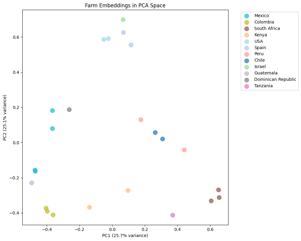
Figure 1: PCA projection of farm embeddings. Farms cluster by environmental similarity, not geography – Peru and South Africa sit close together despite being 10,000 km apart
The map highlighted known production regions, which was reassuring. More interesting were the cross-continental matches: Spain and California overlapped despite being 9,000 km apart. Peru matched South Africa. The model identified environmental analogs across distant regions, which serves as a powerful hypothesis generator for site selection.
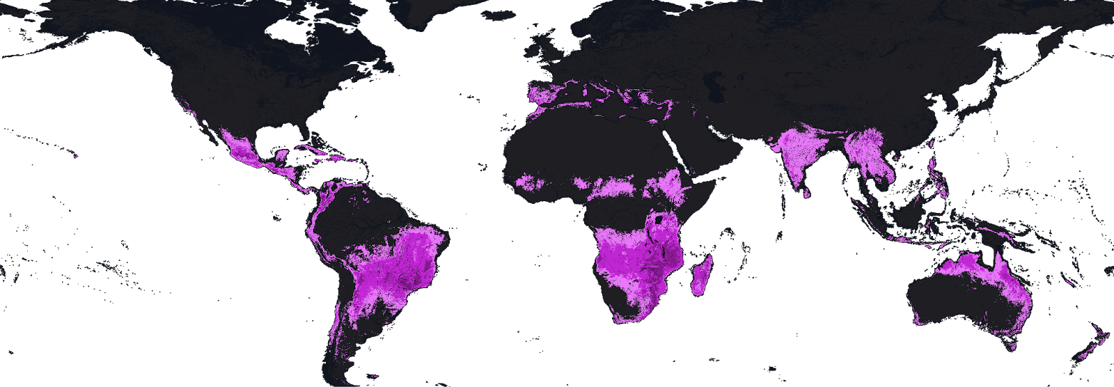
Figure 2: Global similarity map. Global similarity to 24 reference Hass avocado farms. Brighter = higher biophysical similarity. Image by author.
After filtering out established exporters, ten high-scoring potential new regions stood out:
| Country | Region | Likely Match |
|---|---|---|
| 🇦🇷 Argentina | Salta Province | Chilean farms |
| 🇿🇼 Zimbabwe | Manicaland | South African farms |
| 🇲🇼 Malawi | Southern Region | South African farms |
| 🇦🇺 Australia | Queensland | Kenyan farms |
| 🇧🇷 Brazil | São Paulo highlands | Colombian farms |
| 🇨🇷 Costa Rica | Central Valley | Colombian farms |
| 🇷🇼 Rwanda | Western Province | Kenyan farms |
| 🇬🇷 Greece | Crete | Spanish farms |
| 🇮🇹 Italy | Calabria | Spanish farms |
| 🇨🇳 China | Yunnan | Kenyan farms |
Whether these could actually support commercial production depends on many factors the satellite can’t see. But as starting points for investigation, they’re interesting.
What It Can’t Do
Similarity search finds places that look environmentally similar to reference sites. It doesn’t account for water rights, soil chemistry, access to markets, infrastructure, regulations, or pest pressure. A location can match perfectly with biophysical signals and still be unviable.
The approach also inherits whatever biases exist in the reference set. If your 24 farms skew toward irrigated lowland production, the model will find more irrigated lowlands. Diversity in the training data matters.
So this isn’t a replacement for agronomic expertise or on-the-ground assessment. It’s a screening tool, a way to narrow the search space before doing the expensive work.
Where It Gets Interesting
The Hass avocado exercise was a test case. The broader question is what similarity search could enable for agriculture.
Niche crops without suitability maps. Similarity search provides a fast way to screen potential regions for specialty crops like macadamia, saffron, truffles, or dragon fruit. If you have 20-30 reference farms, you can query the entire planet.
Climate adaptation monitoring. Run the same analysis year over year and track how suitability zones shift. Where is it becoming more similar to productive regions? Where is it becoming less? The dataset provides a consistent baseline.
Analog-based knowledge transfer. If a region matches Colombian highland farms, Colombian growing practices-variety selection, irrigation schedules, pest management-are a reasonable starting point for trials. The “likely match” column could be a hint about where to look for relevant expertise.
Investment screening. Before committing to detailed due diligence on a region, a similarity check could serve as a filter and flag whether the biophysics even make sense.
The Bigger Picture
Google made AlphaEarth openly available through Earth Engine. Using it requires some basic programming, but the data barrier is gone. That’s a shift from a world where global environmental analysis required significant resources.
What gets built on top of it is an open question. The avocado map I made is one example. Someone else might use it for reforestation site selection, or renewable energy siting, or tracking ecosystem change. The same infrastructure applies.
For agriculture specifically, similarity search won’t replace the hard work of agronomy, soil science, and market analysis. But it might change where that work starts. Instead of selecting regions based on intuition or proximity, you could select based on environmental analogs and then do the real diligence.
That’s a small shift in process, but it could open up options that wouldn’t otherwise get considered.
Would you like to share your story? Contact us: info@geoawesome.com


#Contributing Writers


Next article
For decades, space was the playground of big organisations be it government agencies with bottomless budgets or massive aerospace corporations. Today, the space sector is much more dynamic and the most exciting breakthroughs aren’t just happening on launchpads; they’re happening on the laptops of entrepreneurs who see the Earth through a different lens. Space technology has evolved into the ultimate problem-solving toolkit, allowing us to tackle everything from climate resilience to urban logistics with surgical precision. If you’re an innovator ready to turn cosmic data into terrestrial value, there is no better “Mission Control” than the CASSINI Challenges.
Organized by the European Union Agency for the Space Programme (EUSPA), this annual competition has quickly cemented itself as the premier launchpad for European space entrepreneurs. It’s more than just a contest; it’s a opportunity bridge between EU Space data and real-world impact. With a massive prize pool and unparalleled access to a network of industry titans and fellow visionaries, the CASSINI Challenges are designed for those who don’t just want to watch the future happen—they want to build it.
What Are the CASSINI Challenges?
The CASSINI Challenges represent one of Europe’s most ambitious space entrepreneurship initiatives, designed to accelerate the development of innovative solutions that leverage EU Space Programme components. These include Galileo (which helps us navigate using satellite signals), Copernicus (which observes the Earth), GOVSATCOM (which ensures secure satellite communications), and SST (which tracks and observes space).
The competition is seeking entrepreneurs, start-ups, and SMEs that demonstrate how space technology addresses important business, social, or environmental challenges while also making Europe more independent and competitive in the global space industry.
The 2026 Competition: Space to Lift Europe
The 2026 edition focuses on the theme “Space to Lift Europe,” encouraging participants to present Minimum Viable Products (MVPs) that meet specific maturity requirements:
- Technology Readiness Level (TRL) ≥ 5: The technology must be validated in a relevant environment
- Commercial Readiness Level (CRL) ≥ 4: Evidence of early market validation and foundational commercial infrastructure
This dual requirement ensures that winning solutions aren’t just innovative concepts but market-ready products with genuine commercial potential.
Who Can Participate?
The competition is open to economic operators (both natural and legal persons) that are based in EU Member States. To submit, you must be at least 18 years old. Participants can apply individually or as teams.
For solutions that use Galileo or satellite navigation, economic operators in Norway and Switzerland can also participate. Solutions that focus on Copernicus or Earth observation can also include participants from Iceland, Norway, and the UK. Also, companies from countries involved in Horizon Europe can take part if their solutions help make the European space industry more competitive.
The Prize: €100,000 for Each Winner
The prizes are significant: twelve winners will receive €100,000 each to help their businesses grow and bring their solutions to market. This competition has a total prize pool of €1.2 million. That makes it one of Europe’s most generous competitions for space entrepreneurs.
Winners get exposure beyond money at the CASSINI Entrepreneurship Days. There, they can present their solutions to investors, accelerators, corporations, and the broader European space start-up community.
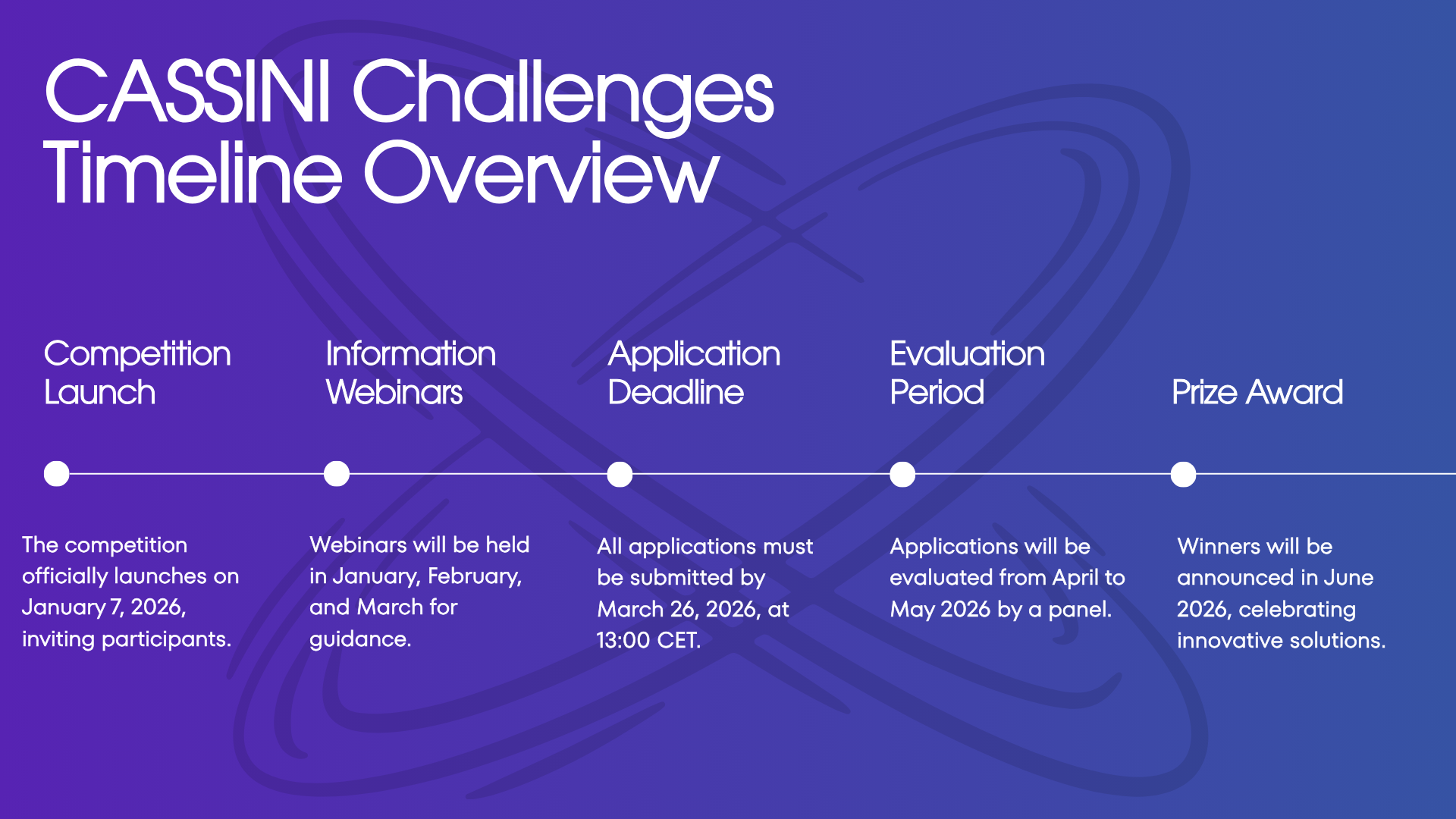
The Evaluation Process
Applications undergo a rigorous two-stage evaluation by an appointed EUSPA Evaluation Committee:
- Initial Assessment: All applications are evaluated against four award criteria (maximum 20 points total)
- Shortlisting: Up to 50 teams are selected to present their solutions online
- Final Evaluation: The committee re-evaluates solutions during presentations and ranks applications
- Winner Selection: The top twelve applications are proposed for award, subject to eligibility verification
The evaluation criteria focus on:
- Relevance to the EU Space Programme (max 4 points)
- Commercial potential and market readiness (max 6 points)
- Innovation and feasibility (max 6 points)
- Execution capability (max 4 points)
Applications must achieve both individual minimum thresholds for each criterion and an overall minimum of 12 points out of 20.
Past Success Stories
Since its inception, CASSINI Challenges has supported 149 winners across multiple editions, each representing breakthrough innovations in space technology applications.
2023 Winners included five groundbreaking start-ups, each receiving €100,000:
- Murmuration: Monitoring tourism’s environmental impact using satellite data
- j-Snow: Providing near real-time snow monitoring with high-resolution satellite data
- Ajuma: Employing satellite data for UV monitoring and skin cancer prevention
- ClearkSky vision: Delivering daily cloud-free Sentinel-2 images using deep learning
- Onocoy: Creating a community-powered network of GNSS reference stations for ultra-accurate positioning
2024 Winners demonstrated the program’s evolution across three tracks (Idea, Prototype, and Product), showcasing solutions ranging from space debris removal to biodiversity monitoring, agricultural optimization, and advanced satellite communication systems.
Information Webinars
To help potential applicants understand the competition, EUSPA hosts information webinars covering:
- MVP technical and commercial requirements
- The competition theme and evaluation criteria
- Application walkthrough and submission tips
- Timeline and key milestones
These sessions provide crucial guidance and allow participants to ask questions directly to the organizing team.
How to Apply
Applications must be submitted through the dedicated CASSINI Challenges platform and include:
- Completed application form
- 3-minute video presenting the MVP and team
- Declaration of ownership
- Declaration of honour
- Identification forms with supporting documents
All materials must demonstrate compliance with minimum TRL and CRL requirements and clearly articulate how the solution leverages EU Space data to address significant challenges.
The CASSINI Challenges represent an extraordinary opportunity for European space entrepreneurs to transform innovative ideas into commercial realities. With substantial prizes, expert evaluation, and access to Europe’s space ecosystem, the competition has established itself as the premier platform for launching space-based businesses.
For more information and to apply, visit www.euspa.europa.eu/cassinichallenges.
Did you like this post? Read more and subscribe to our monthly newsletter!

