15 years ago, Google Maps started out with a simple but ambitious goal to map the entire world. At that time, getting step-by-step directions to where you were headed seemed revolutionary. Today, more than 1 billion people rely on Google Maps to not just navigate from point A to B, but also to shave hours off their commute, explore the world, and discover local businesses. As Google Maps turns 15 on February 8, 2020, it is getting a whole new look and a host of product updates.
The new Google Maps logo
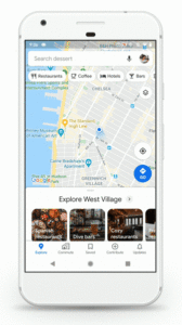 The revamped app is packed with five easy-to-access tabs – Explore, Commute, Saved, Contribute and Updates. The ‘Explore’ tab is home to information, ratings, and reviews of about 200 million places around the world, including restaurants and tourist attractions. ‘Commute’ is where you get real-time traffic updates, travel times, and suggestions for alternative routes. The ‘Saved’ tab will let you view all of the spots you have saved on Google Maps in one convenient place, while the new ‘Contribute’ tab is to let you share local knowledge or add missing places, business reviews, and photos easily. ‘Updates’, meanwhile, will keep you engaged with a steady stream of trending, must-see spots from local experts and publishers.
To commemorate this momentous occasion, several top leaders at Google have also shared their reflections on Google’s geo efforts. For Elizabeth Reid, VP of Engineering, Google Maps, watching Maps grow into what it is today has been an unbelievable experience. “As we’ve added features and capabilities, Google Maps has evolved into much more than a website that gives you turn-by-turn directions. Today, it’s a gateway to exploring the world—both digitally and in real life, on foot or by car, via public transit or a wheelchair. Pardon the pun, but it’s been a long road!” Reid smiles.
And while Google CEO Sundar Pichai cannot stop crediting Google Maps for helping him discover some great burrito places, he is quick to acknowledge how useful the technology can be in places like India where there isn’t always a clear structure to the address system.
“Not only do maps make it easier to get around; they also can give you a sense of identity when you see your street on the map for the first time. That was one of the revelations of MapMaker. Launched by two Google engineers in 2008, it was a way for people to add streets and local landmarks to improve the experience of Google Maps, starting in India. It quickly evolved to help map floods in the Philippines and Pakistan, and later to allow people in the US to add a new road to their neighborhood. Its legacy continues today with Local Guides,” says Pichai, adding that one of the next frontiers for Maps will be to help the billions of people who live without a physical address get a digital one via Plus Codes.
Jen Fitzpatrick, Senior Vice President, Google Maps, points to the role of new technologies like machine learning and artificial intelligence in propelling the future of Maps. “In Lagos, Nigeria alone, machine learning has helped us add 20,000 street names, 50,000 addresses, and 100,000 new businesses—lighting up the map with local places and businesses where there once was little detailed information.”
Maintaining that a truly helpful map reflects on local insights and helps users to find places and experiences that are right for them – instead of just labeling streets and addresses – Fitzpatrick sums up thusly, “When we set out to map the world, we knew it would be a challenge. But 15 years in, I’m still in awe of what a gargantuan task it is. It requires building and curating an understanding of everything there is to know about the physical world, and then bringing that information to people in a way that helps you navigate, explore and get things done in your world. The real world is infinitely detailed and always changing, so our work of reflecting it back to you is never done.”






 The revamped app is packed with five easy-to-access tabs – Explore, Commute, Saved, Contribute and Updates. The ‘Explore’ tab is home to information, ratings, and reviews of about 200 million places around the world, including restaurants and tourist attractions. ‘Commute’ is where you get real-time traffic updates, travel times, and suggestions for alternative routes. The ‘Saved’ tab will let you view all of the spots you have saved on Google Maps in one convenient place, while the new ‘Contribute’ tab is to let you share local knowledge or add missing places, business reviews, and photos easily. ‘Updates’, meanwhile, will keep you engaged with a steady stream of trending, must-see spots from local experts and publishers.