
These location-based mobile tools will help you maintain social distancing

With both the movement of people and COVID-19 cases increasing rapidly in several countries around the world, it has become more crucial than ever to follow rules and regulations (and wear a mask). Social distancing continues to remain one of the most effective ways to stop the spread of the coronavirus, but it can also be quite tricky to follow, especially in crowded places. Here are some free mobile applications that can help:
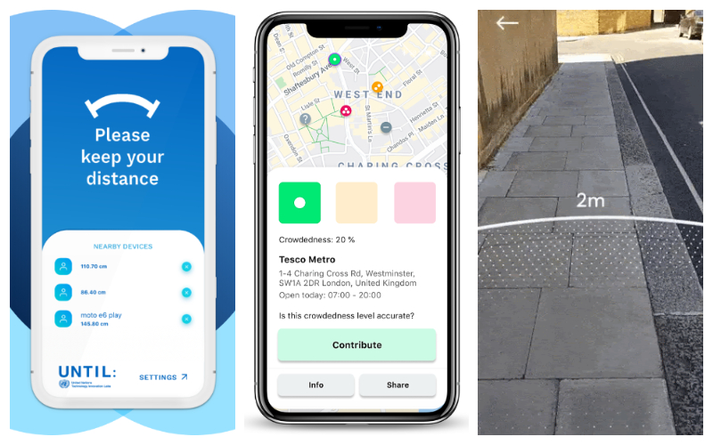
From L to R: 1point5, Crowdless, and Sodar
1point5 by UN Technology Innovation Labs
1point5 measures your distance to other phones and devices as long as the Bluetooth of those phones is turned on. Those other phones do not need to have the app installed for the app to detect their presence. If anyone encroaches your 1.5-meter perimeter (adjustable to 2.5 meters, depending on your preference), the phone will vibrate to alert you.
You can disable alerts from known devices around you and rest assured in the knowledge that the app does not collect any personally identifiable information. The app is available for both Android and iOS devices.
Crowdless by ESA Business Incubation Centre UK
This free app provides live data on the busyness of supermarkets so you can choose to shop when it’s safest for you. Crowdless uses anonymized existing data sources, such as Google Maps and Google Places data, to track the movements of mobile devices. It combines this information with crowd-sourced data by asking the user to confirm whether or not the location is busy.
The app does not store any personal data and your current location is used for the sole purpose of displaying the most relevant search results. You can find the app in both Apple Appstore and Google Play Store.
Sodar by Google
Sodar is a new augmented reality (AR) tool by Google that would allow you to visualize a 2-meter social distancing guideline in your environment. Sodar is not a standalone app and you do not need to install it. You only need to visit its website using the Google Chrome browser on Android devices. Once launched, Sodar will create a radius ring of just over 6 feet around you to help you understand how far you should be standing from others.


#Featured


Next article

Google Maps is probably one of your most frequently used apps, with over 100 million downloads in Google Play alone. But you can do a whole lot more with it than just get directions to places. This post will teach you 7 awesome Google Maps hacks, to make your life easier.
Let’s jump straight in.
Time Travel
Take a trip down memory lane to see how the cityscape has changed over time.
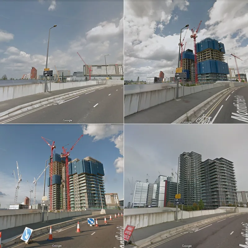
Google has been recording our streets since 2007. They initially mapped major cities in the USA, but have since expanded Google Street View project worldwide, including the UK in 2009. Anyone can go onto Google Maps and see both the most recently recorded frames and the historic ones. This can be a great way to see how the cityscape has evolved over time.
Here’s 4 frames of the same London location, taken by a Google street view car, at different times over a number of years. We can see how it looked before there was a building, during construction and once the building was completed.

Google Maps Hacks: Google Street View
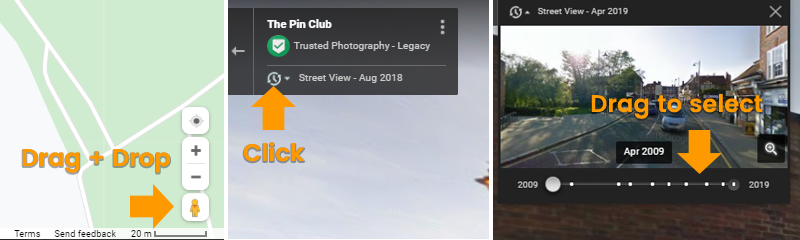
Try this hacks yourself
- Go into Street View (drag and drop the orange man)
- Click the clock icon
- Select a point in the time line
Never forget where you parked the car
Have you ever forgotten where you parked the car, and spent ages looking for it? Then this tip is for you. It’s a real lifesaver when you go exploring a new city. You’ll be able to wander freely without worrying about getting lost. Google Maps will remember where you parked so you don’t have to. Then when you need to go back to the car, just follow the directions right from your phone.
Try this hacks yourself
- Open Google Maps on your phone
- Click the Blue dot that marks your location
- Select ‘Save your parking’. Now your parking is saved!
- When you want to get back to the car, just open Google Maps to do a new search and you should see a parking location option beneath the search box. You can click this to get directions back to your car.
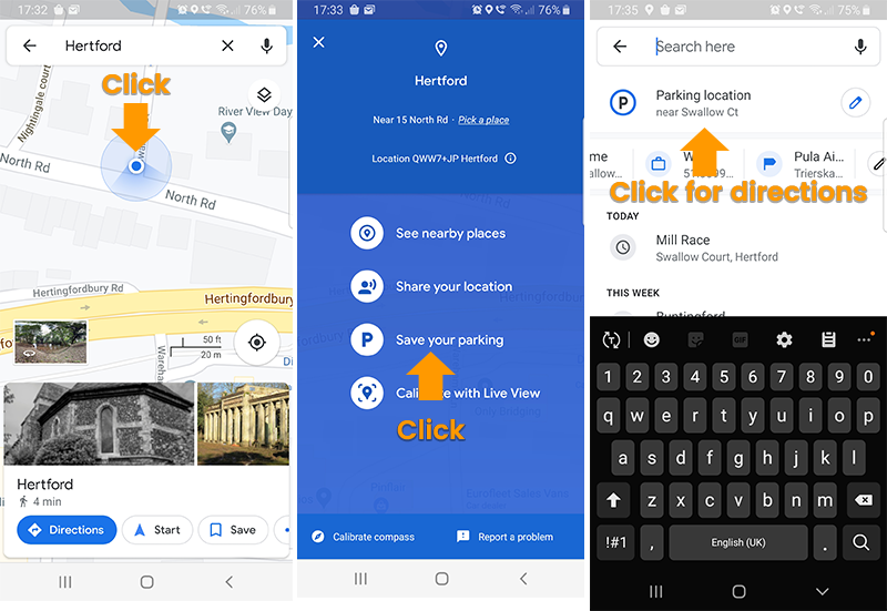
Pro tip: If you click the little pencil icon next to the parking location link, it will show you how long ago you parked there. This can be very useful if you paid to park for a fixed amount of time.
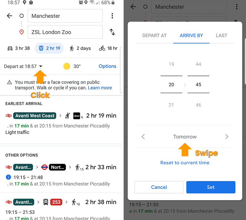
Check public transport times for a future date
You probably know that Google maps offers today’s public transport times, but what if today is a week day and you’re planning a trip for this Sunday? The Sunday schedule might not be the same as today’s. With Google Maps you can set the departure date and time to days or weeks in advance.
If you want to make the most of your day out, there’s even a setting to see what the last public transport for any given day is.
Try this hacks yourself
- Open Google Maps
- Search for the place you want to go
- Hit ‘Get directions’
- Select the public transport method of your choice
- Hit the little ‘Depart at’ link
- Set the date and time you want to arrive or depart on
Plot your own route
If you’re into running you’ll love this. You can plot your very own route in Google maps and embed it into a web page, or share it with your friends.
This feature is just a little less straight forward than the others in this article, so rather than trying to explain it with words and images, check out this video:
[youtube https://www.youtube.com/watch?v=hj9qnKz9NPc]
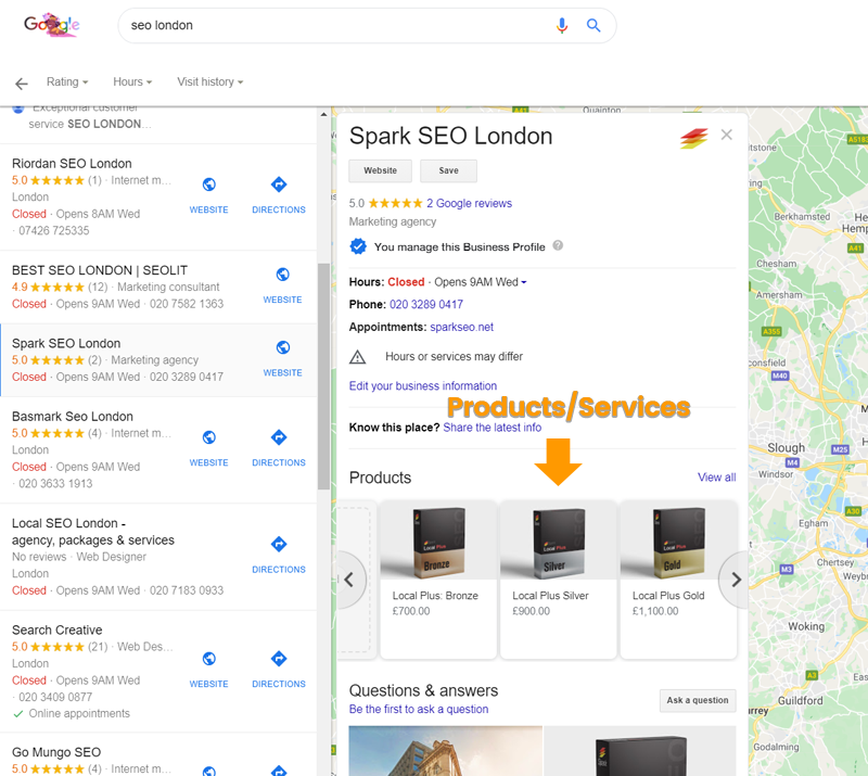
Add your products to Google Maps
It’s no secret that anyone can add their businesses to Google Maps. But it’s probably a lesser known fact that you can add your products there too. Even if you don’t actually offer products, why not add services instead.
Your products or services will appear in a carousel when someone clicks on your business listing. If a user clicks on a product, a pop-up will appear showing the price, a description, a photo and an order button. Here’s what the carousel looks like:
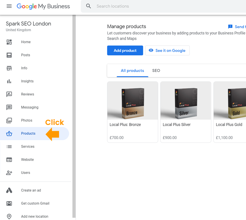
If you have a business on Google Maps already, you can just log in to your Google My Business account and navigate to the products link the left menu. If you don’t have a business in Google yet, its super easy to create one. Here’s some instructions.
Try hacks yourself
- Visit: https://www.google.com/intl/en_uk/business/
- Log in with your Gmail account
- Go to the ‘Products’ link in the left nav
- Click the blue ‘Add product’ button
See all the places you’ve ever visited
It may come as a shock to some people when they first learn that Google knows everywhere that they’ve been. But what’s pretty cool is the fact that that Google let’s you see this information yourself too.
You can use this to either see all the places that you’ve visited, or to see what route you travelled on a specific day. If you set the timeline to just one day, Google will show you the route you travelled, illustrated as blue lines. But, if you set the timeline to a few months or even years, you’ll be able to see all the places around the world that you visited, represented as red dots.
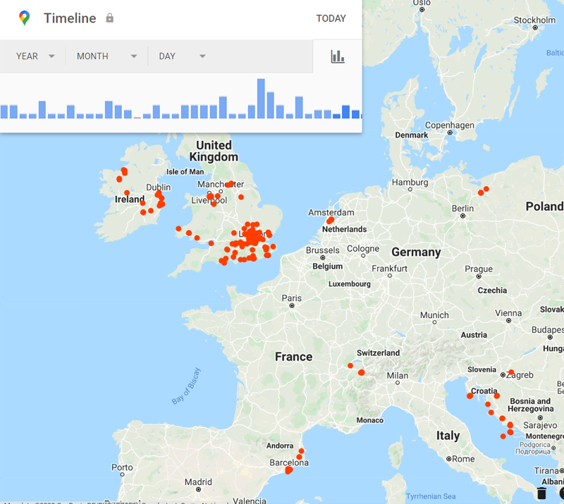
You will need a Google account to try this out, and also have had location tracking enabled.
Try this hacks yourself
- Launch Google Maps: https://www.google.com/maps/
- Tap the more button (three horizontal lines) on the top left corner
- Select ‘Your timeline’ from the menu
- Select a time-frame of your choice using the controls at the top of the map
Measure straight line distances
Whether you want to measure a perimeter, calculate the size of a plot of land or simply get the ‘crow flies’ distance between two points, this feature is the solution for you.
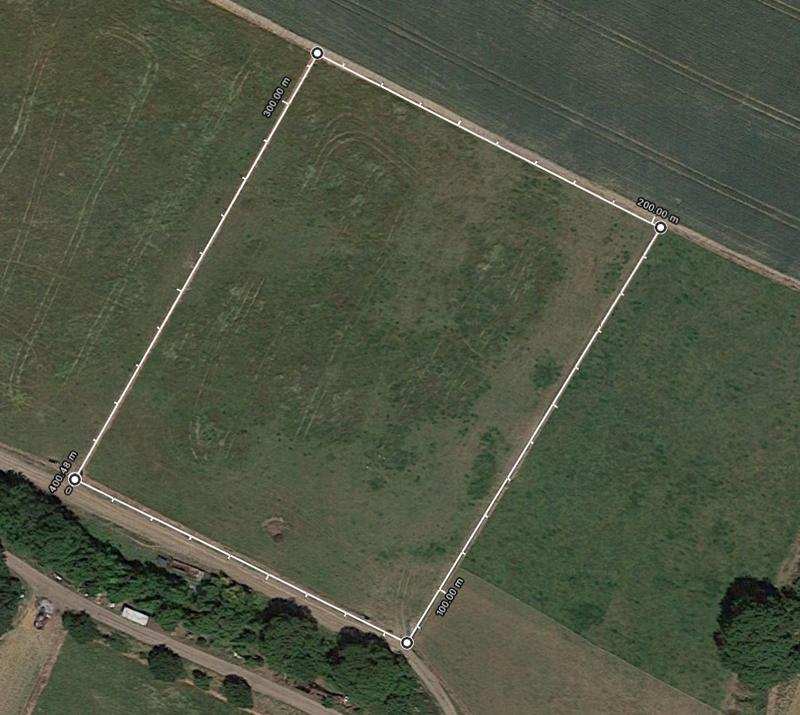
Google Maps Hacks: Measure distance with Google Maps
Try this hacks yourself
- Launch Google Maps: https://www.google.com/maps/
- Select ‘Satellite’ in the bottom left corner
- Navigate to the land you want to measure
- Right click on the place on the map where you want your measurement to start, and select ‘Measure Distance’ from the menu that appears
- Next, click in the place where you want you second point to be. The line with the distance should appear
- To add more points, simply click into the middle of the line. Then drag the new points to wherever you want them on the map
If you enjoyed this post, your friends probably will too, so don’t forget to share it on twitter or facebook.
Did you like this post on Google Maps hacks? Read more and subscribe to our monthly newsletter!

