The New Financial Intelligence Layer: How Banks and Investors Are Building Geospatial AI Capabilities

The intersection of geospatial data and artificial intelligence is reshaping how financial institutions understand risk and opportunity. From sovereign wealth funds managing trillion-dollar portfolios to retail banks assessing property-linked finance, geospatial AI is emerging as a critical capability that transforms location data into actionable financial intelligence. This technology shift isn’t just about better risk assessment—it’s opening an entirely new phase in finance where environmental and spatial factors become core to investment decisions.
This analysis synthesizes insights from the inaugural AI & Geospatial Dialogue session led by Geoawesome in partnership with Kili Technology, featuring perspectives from GIST Impact‘s leadership team and Lloyds Banking Group‘s AI Center of Excellence, examining how major financial institutions are deploying geospatial AI to transform risk assessment and investment strategies.
You can connect with the experts Vineet Gupta, Anushriya Jain and Nataliya Tkachenko-Love on LinkedIn.
The scale of invisible risk in global finance
The numbers paint a sobering picture of why location intelligence has become critical to financial decision-making. According to Vineet Gupta, Chief Product and Technology Officer at GIST Impact, global assets under management exceed $120 trillion, with over $7.5 trillion moving across markets daily. Yet much of this capital flows without clear visibility into environmental and location-based risks.
“Environmental invisibility is a material profit and loss risk,” Vineet emphasized during the discussion. He pointed to Munich RE’s data showing $250 billion in economic losses from disasters in 2023 alone, while over 50% of global GDP—approximately $58 trillion—remains nature-exposed.
These aren’t abstract risks. Mercedes and Jaguar production plants shut down due to floods, causing margin collapse. Droughts cut agricultural outputs in England. California wildfires threatened semiconductor production and data centers, creating systematic disruptions. As Vineet noted, “CFO dashboards might look fine until one fine day when an event occurs and wipes out supply chain and causes the crash.”
Why traditional data approaches fail: The four pillars of data chaos
The inability to see location-based risks stems from what GIST Impact identifies as “data chaos”—four fundamental challenges that have historically blocked effective risk assessment:
- Opaque and fragmented commercial data
- The trust deficit in geospatial data
- The translation gap between geospatial and financial metrics
- Scale versus organizational readiness
Challenge #1: Opaque and fragmented commercial data
Most commercial data remains opaque and fragmented, with assets and supply chain locations rarely disclosed. “Investors are left with a black box of scattered data, outdated spreadsheets,” Vineet explained, noting these inadequate resources must somehow inform trillion-dollar investment decisions.
Challenge #2: The trust deficit in geospatial data
Data quality represents a critical challenge that resonates with findings from previous Kili Technology webinars. As discussed in “Building Reliable Geospatial Training Data for AI”, the challenge of ensuring data accuracy and ground truth verification remains paramount. Vineet’s team found that nearly 30% of asset data in market datasets is mislocated or misclassified—a finding that led to one striking example where a leading asset location dataset listed a Starbucks-anchored office building as a coal mine.
Challenge #3: The translation gap between geospatial and financial metrics
“A flood layer or a biodiversity map doesn’t automatically become a cashflow,” Vineet observed. The challenge lies in translating geospatial signals into financial metrics like probability of default or value at risk, with finance, ESG, and geospatial teams often working in silos without common standards.
Challenge #4: Scale versus organizational readiness
With millions of assets to monitor and regulations moving faster than ever, manual checks and quarterly reporting cannot keep pace with the volume and velocity of change required for effective risk management.
The perfect storm driving Geospatial AI adoption
Four converging forces are making geospatial AI not just interesting but critical to competitive advantage in finance:
AI revolution enables data fusion at scale
Advanced computer vision and transformer architectures now allow institutions to fuse satellite imagery, hazard models, biodiversity maps, and supply chain data into portfolio signals. “We can finally turn pixels into actual portfolio signals,” Vineet noted, highlighting how AI supplements human decision-making rather than replacing it.
Climate urgency accelerates timeline
“Floods, wildfires, and droughts are no longer extreme events—they happen every week,” Vineet emphasized. These impacts are arriving faster than expected, hitting supply chains, insurance models, and GDP exposure in real-time.
Regulatory tsunami demands location-based disclosure
From Basel Committee recommendations being adopted by central banks to Force on Climate-related Financial Disclosures (TCFD), The Taskforce on Nature-related Financial Disclosures (TNFD), and Corporate sustainability reporting (CSRD) regulations, location is becoming what Vineet calls “the new ledger” where investment decisions must account for asset locations and exposures.
Market adoption creates competitive intelligence opportunity
Early movers like Norway’s NBIM (managing $1.8 trillion) and BlackRock are already using location-aware intelligence for competitive advantage. “Compliance is the baseline,” Vineet stated. “The real opportunity lies in using geospatial AI as a competitive intelligence mechanism.”
Building the GeoAI operating system: From chaos to clarity
GIST Impact‘s approach to solving these challenges centers on what they call a “GeoAI operating system” with four integrated components:
Verified data foundations
The importance of data verification echoes insights from “What’s Actually Working in Geospatial AI”, where experts emphasized that ground truth validation remains the foundation of successful geospatial AI deployments. GIST Impact‘s system uses computer vision and geospatial overlays to verify over 3 million assets globally, achieving 99.5% confidence in asset classification.
AI engine for decision-making
Computer vision and language models provide explainable AI that not only reads assets but verifies them and forecasts future scenarios.
Geospatial stack for risk layers
Climate risk, biodiversity, and deforestation layers transform raw data into actionable insights integrated with decision-making systems.
Action platform for delivery
The system delivers intelligence to businesses avoiding supply chain shocks, investors optimizing portfolios, and policymakers making smarter regulations.
Real-world implementation: NBIM’s portfolio transformation
The Norway Government Pension Fund Global (NBIM), managing $1.8 trillion as the world’s largest sovereign wealth fund, provides a compelling case study of Geospatial AI in action. Working with GIST Impact, NBIM conducted portfolio-wide analysis down to the asset level, implementing the Task Force on Nature-related Financial Disclosures (TNFD) framework.
“For the first time, they could quantify exposures in monetary terms,” explained Anushriya Jain, Senior Associate in Product Management at GIST Impact. The analysis enabled NBIM to take actions at three levels: company-level engagement, portfolio-level investment decisions, and market-level support for research and standard-setting.
The ripple effects extend beyond NBIM’s portfolio. “If the world’s largest sovereign fund moves like this, it’s not just affecting their portfolio—it’s changing the game for everyone,” Vineet observed.
Banking sector transformation: Lloyds’ journey from GIS to GeoAI
Nataliya Tkachenko-Love from Lloyds Banking Group’s AI Center of Excellence provided a crucial perspective on how traditional financial institutions are evolving their geospatial capabilities. With over a decade of experience in environmental analytics, she traced finance’s geospatial journey from early 2000s recognition of spatial data’s accuracy advantages through today’s AI-powered transformation.
“Financial institutions started recognizing that geospatial data could capture phenomena that traditional spreadsheet structures couldn’t cover—autocorrelations, dependencies, all those things traditional data entries missed,” Nataliya explained.
The evolution of geospatial in finance
The journey has progressed through distinct phases:
- Early 2000s: Recognition of geospatial data’s superior accuracy
- 2010s: ESG emergence drives demand for environmental data
- 2015: Frameworks developed for risk assessment integration
- 2020s: Focus shifts to data quality, resolution, and provenance
- Present: AI catalyzes transformation with open-source geospatial models from Google, Microsoft, and IBM
Building internal capabilities versus partnerships
Lloyds represents a growing trend of financial institutions developing internal Geospatial AI capabilities. “We’re actually data producers ourselves,” Nataliya noted. “Given AI is becoming more accessible, why wouldn’t we upskill internally and build our own tools?”
This shift toward internal capability development reflects broader industry recognition that geospatial intelligence provides competitive advantage beyond mere compliance. Lloyds recently unveiled plans for property-linked finance instruments requiring high-quality geospatial data for indicators including property conditions, retrofit progress, and local environmental context.
The trust challenge: Building confidence in non-traditional data
Trust remains a fundamental challenge for Geospatial AI adoption in finance, as Nataliya emphasized. “It’s non-traditional data for finance—something they procure externally. The question isn’t just trust but trustworthiness of procured data.”
Key trust-building requirements include:
- Data accuracy and lineage transparency
- Consistent formatting standards (an often-overlooked aspect Nataliya dedicates significant work to)
- Integration with existing technology stacks
- Regulatory compliance and verification
The solution increasingly points toward open-source approaches. “Open source is verifiable, usable by similar actors, and believed to introduce better standardization and increased trust,” Nataliya explained, suggesting financial institutions may soon release their internally developed technologies as open source for sector-wide benefit.
Measuring impact: The ROI challenge and opportunity
While the strategic value of Geospatial AI is clear, quantifying return on investment remains challenging. Nataliya’s research found limited concrete metrics, with estimates suggesting approximately 3.2x returns—though she acknowledged the need for more robust industry data.
European asset managers working with GIST Impact have demonstrated measurable improvements:
- 42% lower biodiversity footprint compared to benchmarks
- 40% lower impact intensity across air, water, and land
- Identification of 19% of manufacturing assets near protected biodiversity hotspots
These metrics translate into both risk reduction and opportunity identification, with frameworks like Species Threat Abatement and Restoration enabling managers to identify locations for positive environmental impact alongside financial returns.
The human-AI partnership: Augmentation, not replacement
A critical insight from both presenters was the importance of human expertise in Geospatial AI deployment. “AI brings data and speed—automation of routine analysis, forecasting risks, pinpointing hotspots,” Vineet explained. “But humans bring context and judgment, ethical considerations, and qualitative nuances.”
He shared a cautionary example where AI recommended closing a polluting factory without recognizing it was the only employment source for 10,000 people in a 300-square-kilometer radius. “Together, humans and AI create collaborative intelligence where decisions are not only faster but defensible and smarter.”
Looking ahead: From reactive to prescriptive intelligence
The financial industry’s Geospatial AI maturity journey is progressing from reactive reporting of past events through diagnostic understanding toward predictive and ultimately prescriptive real-time intelligence. Most institutions currently operate between reactive and diagnostic stages, but leaders are pushing toward predictive capabilities.
“This is not a dream or future vision—it’s actually happening,” Vineet emphasized. “With a click of a button, portfolios can be analyzed against nature and climate risks.”
As 2025 progresses, both presenters see acceleration in adoption driven by regulatory requirements, competitive pressure, and technological advancement. Nataliya’s “aspirational” view for 2026 includes financial institutions releasing their geospatial technologies as open source, fostering sector-wide innovation and trust.
Key takeaways for financial institutions
The discussion revealed several critical insights for organizations considering or expanding Geospatial AI capabilities:
- Data quality remains foundational: Without verified ground truth, even sophisticated AI models fail—reinforcing the importance of robust data annotation and validation processes.
- Scale requires automation: Manual processes cannot handle millions of assets and daily environmental changes; AI-powered systems are essential for operational viability.
- Translation is critical: Success requires bridging geospatial insights to financial metrics that drive actual decision-making.
- Early movers gain advantage: Institutions treating Geospatial AI as competitive intelligence rather than mere compliance are already seeing portfolio benefits.
- Collaboration accelerates progress: Open-source approaches and cross-sector partnerships can address trust challenges while accelerating innovation.
About Kili Technology’s role in Geospatial AI
As organizations navigate the complexities of Geospatial AI implementation, having the right data infrastructure becomes critical. Kili Technology’s geospatial annotation platform addresses the foundational challenge of data quality that underpins successful deployments. The platform provides enterprise-grade security and data sovereignty controls essential for financial institutions, while enabling the precise annotation and validation of satellite imagery, aerial photography, and other geospatial data types. By ensuring ground truth accuracy and maintaining complete control over sensitive location data, Kili Technology helps organizations build the verified data foundations that, as this webinar demonstrated, are essential for transforming the hundred-trillion-dollar blind spot into clear, actionable intelligence.
About Geoawesome’s GeoAI Community Series in partnership with Kili Technology
AI is rapidly changing every sector, including ours, by transforming how we collect, process, and interpret geospatial data through advancements like predictive analytics and automated feature extraction.
Given the overwhelming pace of technological progress, there’s a growing need for expert-led discussions. Geoawesome has launched a five-part digital event series in partnership with Kili Technology, featuring leading experts who will conduct in-depth analyses of critical topics shaping the future of AI & Geospatial (GeoAI).
Join us as we explore:
- Foundational Models: The new building blocks for GeoAI. (Monday 29th September, 2025)
- AI & Geospatial in the Financial Sector: The impact of AI on corporate reporting, ESG, and investment. (Watch the full webinar on demand)
- Integrity, Trust, and Provenance: Ensuring the reliability and ethics of AI-driven geospatial data. (Monday 13th October, 2025)
- Collaboration & GeoAI for Good: Leveraging GeoAI for humanitarian and environmental applications. (Monday 3rd November, 2025)
- State of the Industry: A look at the key trends and future direction of GeoAI. (Monday 1st December, 2025)
Do you have expertise in one of these areas and are interested in speaking? Or do you have specific questions you’d like to see addressed? Please reach out to muthu@geoawesome.com.


#GeoAI


Next article
We rely on it daily – whether navigating to a new café, tracking a package, or mapping a field. But how does GPS work, and what exactly is GNSS? Let’s discover the invisible technology that powers modern life.
The Birth of GPS: A Cold War Invention
Although in everyday language, GPS is often used to describe any location-tracking device, in reality, it refers specifically to the American satellite navigation system. The Global Positioning System (GPS) was born out of military necessity during the Cold War. Developed by the U.S. Department of Defense, the system was designed to provide accurate positioning for strategic military operations.
- 1973: GPS concept approved by the DoD.
- 1978–1985: First satellites launched (Block I).
- 1995: Declared fully operational with 24 satellites.
Its design was inspired by earlier satellite navigation experiments like TRANSIT, and has since grown into a globally critical system. Today, it’s freely accessible for civilian use across the world.
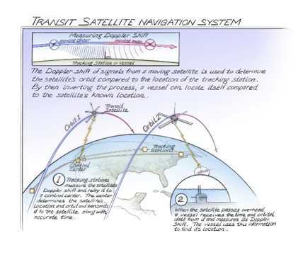
Transit Satellite Navigation System. Source
GNSS: A Constellation of Constellations
GNSS (Global Navigation Satellite Systems) refers to all satellite-based positioning and timing systems, including but not limited to GPS. These systems are the backbone of modern navigation, geospatial applications, and timing services.
Major Global Systems:
- GPS (USA): Operational since 1995, maintained by the U.S. Space Force.
- GLONASS (Russia): Developed in the 1980s; global coverage restored by 2011.
- Galileo (EU): Launched by the European Union; full services expected by 2027.
- BeiDou (China): Began as a regional network in 2000 and achieved full global coverage in 2020.
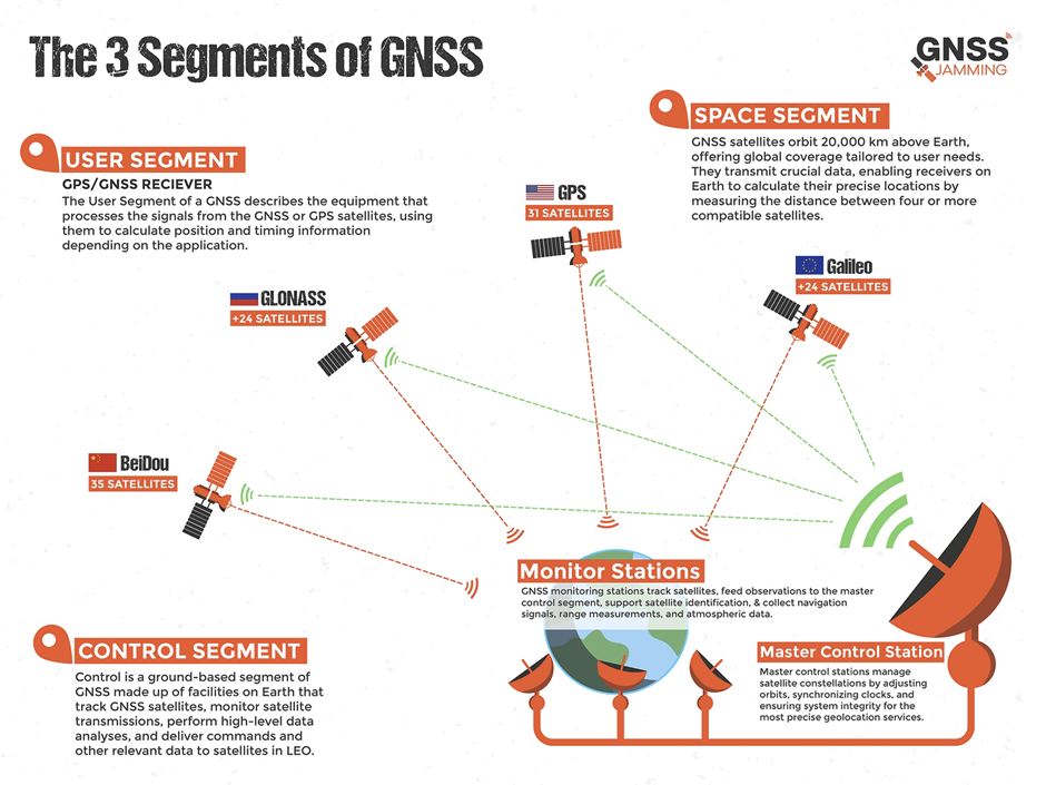
The Three Segments of Each GNSS:
- Space Segment: The satellites orbiting the Earth that broadcast positioning and timing signals.
- Control Segment: The network of ground stations that monitor, maintain, and update the satellites and their signals.
- User Segment: The receivers and devices (from smartphones to surveying instruments) that capture GNSS signals to calculate precise location and time.
Each GNSS operates independently but modern receivers can combine signals from multiple constellations (multi-GNSS) to improve accuracy, reliability, and redundancy for applications on land, sea, air, and even in space.
How GNSS Positioning Works?
Understanding GNSS Signal Processing and Error Correction by Geoawesome
How to Measure the Accuracy of GNSS? – DOP, RTK, and PPP
Raw GNSS signals can be off by several meters, but accuracy can be enhanced dramatically using correction methods:
Main Error Sources:
- Ionospheric and tropospheric delays
- Multipath effects (signals bouncing off surfaces)
- Clock and orbital inaccuracies
Accuracy Enhancement Techniques:
- DOP (Dilution of Precision): Describes satellite geometry; lower values = better accuracy.
- RTK (Real-Time Kinematic): Uses a nearby base station for cm-level accuracy.
- PPP (Precise Point Positioning): Relies on corrections from global services (e.g., IGS).
GNSS – Do It Yourself!
Explore RTKLIB – an open-source GNSS processing suite for post-processing and real-time kinematic positioning.
More Educational Resources:
- GPS.gov – U.S. government’s hub for all things GPS.
- ESA NAVISP – European research program for GNSS innovation.
- https://guide-gnss.com/gnss-map/
- https://network.igs.org/
Further Reading:
- 2006, Global Positioning System Signals, Measurements, and Performance
- Who invented GPS?
- Understanding GPS/GNSS
How do you like this article? Read more and subscribe to our monthly newsletter!
About Kili Technology’s role in Geospatial AI
As organizations navigate the complexities of Geospatial AI implementation, having the right data infrastructure becomes critical. Kili Technology’s geospatial annotation platform addresses the foundational challenge of data quality that underpins successful deployments. The platform provides enterprise-grade security and data sovereignty controls essential for financial institutions, while enabling the precise annotation and validation of satellite imagery, aerial photography, and other geospatial data types. By ensuring ground truth accuracy and maintaining complete control over sensitive location data, Kili Technology helps organizations build the verified data foundations that, as this webinar demonstrated, are essential for transforming the hundred-trillion-dollar blind spot into clear, actionable intelligence.
About Geoawesome’s GeoAI Community Series in partnership with Kili Technology
AI is rapidly changing every sector, including ours, by transforming how we collect, process, and interpret geospatial data through advancements like predictive analytics and automated feature extraction.
Given the overwhelming pace of technological progress, there’s a growing need for expert-led discussions. Geoawesome has launched a five-part digital event series in partnership with Kili Technology, featuring leading experts who will conduct in-depth analyses of critical topics shaping the future of AI & Geospatial (GeoAI).
Join us as we explore:
- Foundational Models: The new building blocks for GeoAI. (Monday 29th September, 2025)
- AI & Geospatial in the Financial Sector: The impact of AI on corporate reporting, ESG, and investment. (Watch the full webinar on demand)
- Integrity, Trust, and Provenance: Ensuring the reliability and ethics of AI-driven geospatial data. (Monday 13th October, 2025)
- Collaboration & GeoAI for Good: Leveraging GeoAI for humanitarian and environmental applications. (Monday 3rd November, 2025)
- State of the Industry: A look at the key trends and future direction of GeoAI. (Monday 1st December, 2025)
Do you have expertise in one of these areas and are interested in speaking? Or do you have specific questions you’d like to see addressed? Please reach out to muthu@geoawesome.com.

