
The Deep Tech Revolution in Geospatial: Where Science Meets Real-World Impact

For years, geospatial technology was synonymous with maps and satellite imagery. But beneath the surface, a much deeper transformation has been underway. Today, geospatial is no longer just a question of “where.” It’s about how we observe, analyze, and predict the world with a level of precision, speed, and scale that was previously unthinkable.
At the heart of this evolution is Deep Tech — a class of technology driven by advanced science, long-term research, and engineering breakthroughs that cross multiple disciplines. In sectors ranging from climate resilience to defense, geospatial Deep Tech is unlocking entirely new capabilities, opening fresh markets, and solving increasingly complex global challenges.
What Exactly Is Deep Tech — And Why Does It Matter for Geospatial?
Deep Tech sits at the intersection of science and application. These are not off-the-shelf software products or incremental app improvements. Instead, they involve years of scientific discovery, high-risk engineering, and often, the blending of hardware, algorithms, and massive data.
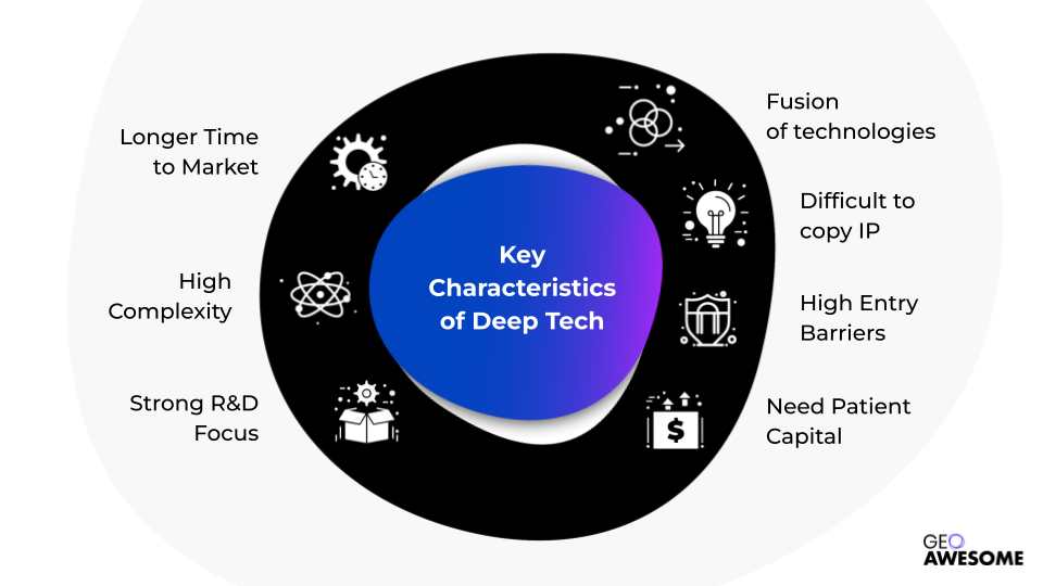
In geospatial, this means everything from next-generation Earth observation satellites to AI models that analyze real-time imagery, to quantum-based navigation systems that work even when GPS signals fail.
At its core, Deep Tech in geospatial changes not just what we can see, but how fast we can see it, how deeply we can analyze it, and how confidently we can act on it.
The Deep Tech Domains Fueling Geospatial Innovation
At the center of this transformation is a growing stack of scientific disciplines and technologies working together:
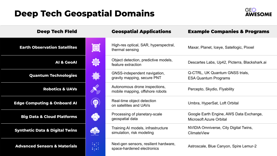
What’s remarkable here is that no single domain can deliver these breakthroughs alone. A hyperspectral satellite, for example, may generate highly detailed imagery. But its true commercial and operational value only emerges when combined with AI models that can process and classify that data in near real-time, cloud platforms capable of managing petabytes of information, and edge computing that can filter signals before transmission.
This is the defining characteristic of Deep Tech: its power lies in convergence — where multiple advanced technologies collaborate to create solutions that none could achieve in isolation.
Why Geospatial May Be the Most Natural Deep Tech Industry
While many sectors are experimenting with Deep Tech, geospatial may be one of the few industries that practically require it.
Consider the operational environment: satellite constellations capturing imagery around the clock, generating petabyte-scale datasets; autonomous drones navigating complex urban or industrial sites; government agencies monitoring forests, coastlines, or urban infrastructure in real time. The precision requirements are extreme — often demanding sub-meter or even centimeter-level accuracy — and the decisions based on this data frequently have life-or-death or multi-billion-dollar implications.
This unique intersection of hardware, algorithms, and mission-critical urgency means that geospatial companies are often solving some of the hardest technical challenges in the entire Deep Tech landscape. The result: when they succeed, they don’t just build better maps — they enable entirely new business models.
Deep Tech Use Cases Are Already Commercial
Perhaps the most telling sign of geospatial’s Deep Tech momentum is how quickly the commercial use cases are maturing:
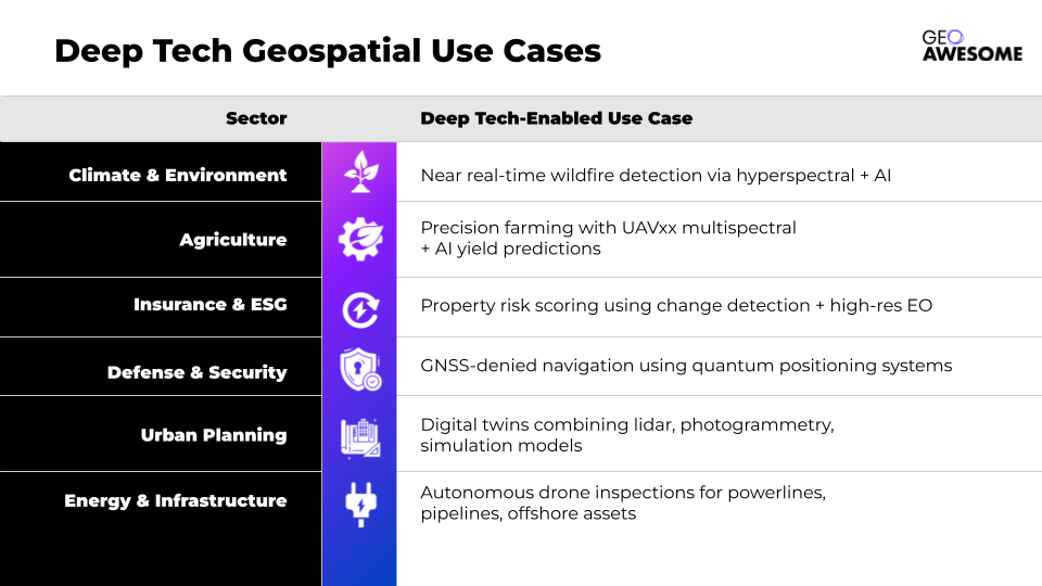
These aren’t science experiments. From early wildfire detection to AI-powered crop forecasts and autonomous inspection drones, many of these solutions are already in operation today — deployed by insurers, governments, energy companies, and defense organizations worldwide.
What’s especially notable is how automation and prediction are emerging as the dominant themes. What once required teams of analysts and months of post-processing is increasingly becoming real-time, continuous, and scalable — allowing for operational decisions that are not just better informed, but faster and more resilient to change.
The Real Acceleration: Deep Tech Convergence
While individual technologies are advancing rapidly, the real acceleration in geospatial Deep Tech is happening at the points where multiple disciplines intersect:
- AI + EO + Edge Computing → Allowing real-time analytics directly from orbit or drones, dramatically reducing latency between observation and action.
- Quantum + GNSS + Sensor Fusion → Enabling navigation systems that remain accurate even in GPS-denied environments, a critical capability for defense and autonomous operations.
- Digital Twins + Climate Models + Predictive AI → Giving governments and insurers new tools to forecast urban risk, optimize infrastructure, and prepare for climate-driven events with far greater accuracy.
In this world, the companies best positioned to lead are not necessarily those who excel in one domain, but those capable of orchestrating multi-domain integrations into defensible, scalable solutions. The new competitive advantage is systems integration at the frontier of science.
The Takeaway: Geospatial Deep Tech Is Already Here
This is no longer a five-year vision — it’s already reshaping how we monitor the planet, manage infrastructure, respond to disasters, and forecast risk.
- The sensors are smaller, cheaper, and more advanced.
- The AI models are more powerful and better trained.
- The cloud infrastructure is finally built to scale.
- The scientific barriers that limited the sector for decades are rapidly falling.
Geospatial sits at the intersection of some of the most exciting frontiers in Deep Tech. As advances in sensors, AI, quantum, and autonomy accelerate, we’re entering an era where location intelligence is not just about “where” — but about “how fast,” “how deep,” and “how predictive.”
Do you like this article? Read more and subscribe to our monthly newsletter!

#GeoAI


Next article

Editor’s Note: This article is part of Geoawesome’s Guest Contributor series, where members of our global geospatial community share their insights and experiences. We believe good ideas get even better when shared. Got your own take on how geospatial, EO, AI, or maps are shaping the world? We’re always looking for fresh voices, drop us a line (info@geoawesome.com) and let’s make the world a little more awesome together.
In the fight against deforestation, land conversion and smallholder exploitation, technology is an incredibly powerful tool.
We’re seeing a huge number of technical tools coming to market, powered by satellite data and AI. They’re empowering organisations and individuals to improve traceability, ensure compliance and drive supply chain sustainability.
In many cases, these platforms are being lauded as all-in-one solutions that will lead to a world where deforestation, environmental degradation and unsustainable practices can be quickly and easily monitored and prevented. The promise is that anyone can now track forest loss, monitor wildfires, or even estimate carbon emissions – without ever having to step foot in the areas they are monitoring.
While the potential of these tools is undeniable (in fact, we offer a tech platform at MosaiX), technology is only one part of a much wider solution, and an over-reliance on data platforms and tools comes with critical limitations and real risks.
In this article, I’ll explain why depending on technology alone is so counterproductive.
The Positive Forces Driving Tech Adoption
I’s important to acknowledge that the widespread adoption of these tools is positive. It’s a sign that an ever-increasing number of organisations are taking their responsibilities seriously and making No Deforestation, No Peat, and No Exploitation (NDPE) commitments.
It also reflects the legislative progress, and the efforts of NGOs and governments to drive sustainable change, through the introduction of landmark legislation like the EU Deforestation Regulation (EUDR).
When used properly, technology tools can provide accessible, effective and accurate monitoring that can provide real insights and accountability. With the right data, high-quality satellite imagery, land ownership mapping and AI pattern recognition, you can gain invaluable insights that can help you to prevent land conversion – and hold those responsible for deforestation to account.
The problem is that getting accurate information is much harder than it seems.
Promise vs. Reality: Data Quality
With technology platforms and AI insights, the outputs are only as good as the inputs, and these are often hampered by significant data quality issues. Information can be inaccurate, outdated, or suffer from a lack of granularity. For instance, most deforestation analysis tools can tell you where deforestation is happening, but not necessarily who is responsible or why.
Another big issue is that many platforms depend on open-source satellite and land ownership data. While this can give the illusion of transparency, it can also be woefully inaccurate!
When data inputs are poor, the outputs follow. Without rigorous verification, contextualisation, and experts on the ground, these tools risk oversimplifying complex situations or, worse, generating misleading conclusions.
Data quality can be particularly poor when it comes to critical information, such as land tenure details, intricate supply chain relationships, and verified corporate ownership structures. This data is often scattered across disconnected systems, difficult to access, or inconsistently formatted, hindering the ability of AI tools and technology platforms to deliver a coherent, accurate and complete picture.
The result is that customers using these tools end up missing relevant deforestation and having to manage a significant number of false alarms! This confusion can be a serious risk for businesses that want to stay compliant or investors looking for protection against greenwashing claims.
The Interpretation Gap: Beyond Pixels and Alerts
Raw data and automated alerts, however sophisticated, can’t understand the full picture. To do that, you need an expert. An alert for tree cover loss, for example, doesn’t inherently distinguish between illegal deforestation and natural disturbances. This “interpretation gap” can further muddy the picture.
There is a crucial, often underestimated, need for expert analysis to dissect the data, understand its nuances, and verify findings on the ground. Local context is essential, and no tech platform can interpret data through the context of unique social dynamics, customary land rights, existing legal frameworks, specific local laws and regulations, and the intricacies of different commodity sectors!
These factors all play a vital role in accurately understanding and addressing sustainability risks. Technology can reveal patterns and present this data, but it cannot, by itself, capture the full picture. That’s where people, systems, and relationships come in. For a complete solution, all data needs to be validated and interpreted with human expertise.
Turning Alerts into Intervention
The next challenge is what companies do with the data they get from the tech platforms. Even when the technology works perfectly and provides an accurate alert, companies often struggle to translate this information into meaningful, timely, and appropriate actions on the ground.
On one hand, there’s the risk of unnecessary supplier exclusion based on incomplete or misinterpreted automated alerts, potentially damaging livelihoods and severing valuable relationships. On the other, failing to respond effectively to deforestation due to a lack of clarity or capacity can mean that destructive practices continue unchecked – causing environmental damage and the reputational damage that comes from it.
To truly address deforestation linked to a specific commodity, you need accurate, up-to-date plantation maps, verified corporate ownership data, and a fully traceable supply chain, from growers to market.
Relationships matter here, and the companies using tech tools need to know who the key decision-makers are within all their suppliers and how to engage with them constructively when problems arise. Technology might be able to identify the issue, but it isn’t going to make the call to the relevant person at the grower to address the issue!
Compliance & Legal Risks
With the introduction of regulations like the EUDR, the Corporate Sustainability Due Diligence Directive (CSDDD), and the Corporate Sustainability Reporting Directive (CSRD), the need for effective due diligence and accurate data is growing.
Superficial reliance on technology platforms and automated assessments is no longer sufficient and exposes companies and investors to significant legal and reputational risks.
The EUDR, for example, demands verifiable proof that products are deforestation-free, including precise geolocation data for plots of land. Companies also need traceable, defensible data and auditable processes as part of their due diligence.
The consequences of non-compliance are high, from warnings and significant fines to potentially being disqualified from the entire market! Traditional methods of supply chain monitoring, like supplier self-reporting and periodic on-site audits, are no longer enough to meet the demands. All issues need to be treated as seriously as any other legal case: carefully documented, evidence-based, and demonstrably compliant with regulatory requirements.
From Greenwashing to Techwashing
We are seeing an increasing number of entities dressing up their sustainability claims with impressive-sounding technological jargon, like “AI-powered”, “blockchain-enabled”, or “satellite-based monitoring”. Without the backing of robust processes, deep-seated expertise, or genuine accountability, this is simply a form of greenwashing! Technology becomes a marketing tool rather than a solution.
Techwashing claims like this risk doing more harm than good. They can create a false sense of security for businesses, who feel like they are ‘covered’ without having to take meaningful action. They can also cause confusion and reputational backlash among investors, regulators, and consumers trying to distinguish real progress from empty promises.
Integrating Technology with Expertise
The true value of tech tools depends entirely on who is using them and how.
To be effective in preventing deforestation, land conversion, and broader environmental, social, and governance (ESG) risks requires the input from a team with the right expertise, systems and resources. This means:
- Prioritising Data Integrity: Moving beyond reliance on unverified open-source information and investing in the verification and contextualisation of local data.
- Bridging the Interpretation Gap: Recognising that technology must be coupled with human expertise – analysts who understand local socio-legal contexts, sector-specific dynamics, and the nuances of corporate structures. Different commodities and regions require tailored approaches – what works for cocoa in West Africa may not work for palm oil in Southeast Asia or soya in Brazil.
- Taking Action: Developing systems for turning alerts into engagement and effective interventions – involving the people that matter.
- Taking Due Diligence Seriously: Moving beyond box-ticking to implement traceable, evidence-based systems that comply with regulations and demonstrate genuine commitment.
- Demanding Accountability: Ensuring claims of “tech-driven sustainability” are backed by tangible processes, proven expertise, and measurable impact.
Creating truly sustainable supply chains requires us to harness the power of technology responsibly. This means acknowledging its limitations, mitigating its risks, and integrating it with the irreplaceable value of human expertise.
By Priscillia Moulin, Co-founder and Director of Strategy – MosaiX – https://mosaix.earth/
About MosaiX
MosaiX is a Netherlands-based company that provides organizations throughout the supply chain with data-driven, real-world solutions for sustainability, compliance, and responsible sourcing.

