#Business #Featured

Police can request your Location History from Google Maps Timeline

Google Watching You - Geoawesomeness

If you’re criminal and you have Android phone or you use Google Maps on iOS you should consider switching back to your old feature phone. The Verge reported about several cases where police have filed warrants requesting from Google the location logs of suspects.

The requested data is collected by a little-known service called Google’s Location History. We’ve been writing about it multiple times over the last few years as well as last July when the official coming out of the service happened as it has been added to Google Maps app in the form of the Timeline feature.

Google says that the Timeline helps you add a spatial layer to your memories but frankly speaking what it actually does is showing users that the company not only stores the information about our whereabouts but also deeply analyses it. The service is a clear evidence that Google records when and where your smartphone was and today Google’s policy is to comply with law enforcement requests for this location data.

According to the US’ Fourth Circuit Court of Appeals which recently analysed the case asking a company for smartphone location data voluntarily shared by a users doesn’t represent a search under the Constitution’s Fourth Amendment, and therefore doesn’t need a warrant. According to the judges volunteering your geographic position information means you’ve consciously given up a “reasonable expectation of privacy” to a 3rd party.

No matter if we want to hide something or not it make sense be aware of sort of data we are sharing with the world. In that post we’ve listed all services where Google might be tracking your personal information and in many cases you can manage the privacy settings to keep it private. It’s worth taking some time to review it.

It is also worth mentioning that the capability is far more widespread on Android phones than iOS. While both system can calculate your geographic position with a similar accuracy, the Location History functions can’t easily log that data outside of the Android ecosystem.

Say thanks for this article (1)
The community is supported by:
Become a sponsor
#Business
#Business #Environment #Featured
Unlocking the Future: Key Trends in Geospatial Technology for 2025
Aleks Buczkowski 12.25.2024
AWESOME 8
#Business #Ideas
Urban Digital Twins in China: A Smart Gadget or a Decision Support Tool?
Nianhua Liu 03.28.2024
AWESOME 4
#Business #Featured #GeoDev
Geo Addressing Decoded Part 2: Beyond Coordinates – Exploring the Depth and Impact of Geo Addressing
Aleks Buczkowski 05.2.2024
AWESOME 4
Next article
#Business #Ideas

This German start-up will protect you from areal intruders

dedrone-your-industry-300dpi

Drones are more affordable than ever before. Only last year around $1m consumer flying devices were sold globally, most of them equipped with video cameras. While most of us are concerned about dronerelated safety issues, privacy becomes more and more relevant problem in the context of photos taken from above.

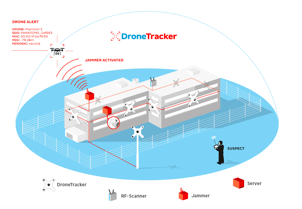
Dedrone is German start-up that tries to address this issue with a system which monitors the skies and tells people when drones have entered their airspace.

The company’s flagship product is called DroneTracker and it is based on a set of sensors installed on the ground around a venue. It uses audio, video, Wi-Fi and RF sensors to identify flying intruders. When the system identifies a drone it activates the jammer which transmits electromagnetic waves that interfere with the radio signal between remote control unit and drone or a GPS if a drone is flying in an automatic mode. As a result the device gets disoriented and it automatically comes back to its take off location or simply land.

Dedrone Geoawesomeness

The company has been funded in 2014 and with 1.5 years they started to sell their products world-wide and employed 40 people. Last month the company announced that it has raised $10 million in Series A funding. It shows that there is a huge potential in that niche and the company says that their system has been already deployed in multiple locations including prisons, airports, stadiums, police and industrial companies among others.

Many players on the market are focussing on drone safety like PrecisionHawk with their LATAS – drone air traffic management system but the idea to focus on privacy and privacy related safety niche is unique and awesome!

Read on
Search