PNT Security Alert: Protecting Geospatial Data Integrity from GNSS Jamming and Spoofing

The Global Navigation Satellite System (GNSS), encompassing GPS, Galileo, GLONASS, and BeiDou, is the engine powering modern geospatial operations, spatial analytics, agriculture automations, infrastructure maintenance, telecoms and banking. For the global community, the reliable integrity of Positioning, Navigation, and Timing (PNT) is non-negotiable. However, targeted interference, once a rare curiosity, has evolved into a recurring operational hazard that can degrade the quality of location and timing data.
Adversaries or careless users employ two primary methods to compromise GNSS accuracy: spoofing and jamming.
Understanding the Threat: Jamming vs. Spoofing
| Attack Type | Technical Mechanism | Geospatial Impact |
| Jamming | A jammer transmits a strong signal within the same frequency band as GNSS satellites. Because real satellite signals reaching Earth are extremely weak, even a low-power local transmitter can significantly raise the noise floor, preventing a receiver from acquiring or tracking satellites. | The effect is data denial. The GNSS receiver either reports low-quality fixes or fails to provide position or time data entirely, potentially halting remote sensing missions or critical PNT-dependent processes. |
| Spoofing | The attacker transmits counterfeit satellite signals that precisely mimic real GNSS signals but carry false timing or position data. Advanced spoofers carefully shape the signal timing and power to “capture” the victim receiver without triggering immediate alarms. | This attack misleads navigation systems. The receiver accepts the forged signals as authentic, reporting a subtly or dramatically incorrect location or time. Spoofing is often harder to detect than jamming. |
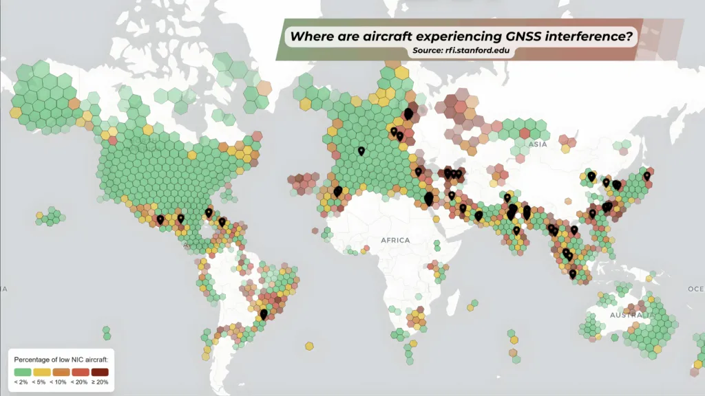
GNSS Jamming vs. Spoofing by Geoawesome
Global Hotspots: Where Data Integrity is Most at Risk
For those processing EO data or deploying assets globally, understanding the spatial distribution of GNSS interference is crucial. Open monitoring initiatives convert datasets, such as aircraft GNSS performance (ADS-B), into spatial heatmaps that quantify the extent of the interference.
Current monitoring shows interference is not uniformly distributed, revealing three key patterns:
- Conflict and Near-Conflict Zones: Persistent, high rates of both jamming and spoofing are frequently observed around the Baltic, Black Sea, and Barents regions. These events are often correlated with electronic-warfare operations, affecting civil aviation and maritime users who report repeated outages and falsified location reports (such as corrupted Automatic Identification System (AIS) and GNSS data).
- Regional Flashpoints: Intermittent but concentrated interference clusters are recorded in the Middle East, parts of South Asia, and specific Southeast Asian corridors. These events are linked to military activity or instances of criminal masking of vessel tracks.
- Localized Civilian Misuse: Lower-power, handheld jammers used by individuals (for privacy, to defeat trackers, or by illegal operators) create real, small-scale disruptions in urban areas, ports, or specific lanes across many countries.
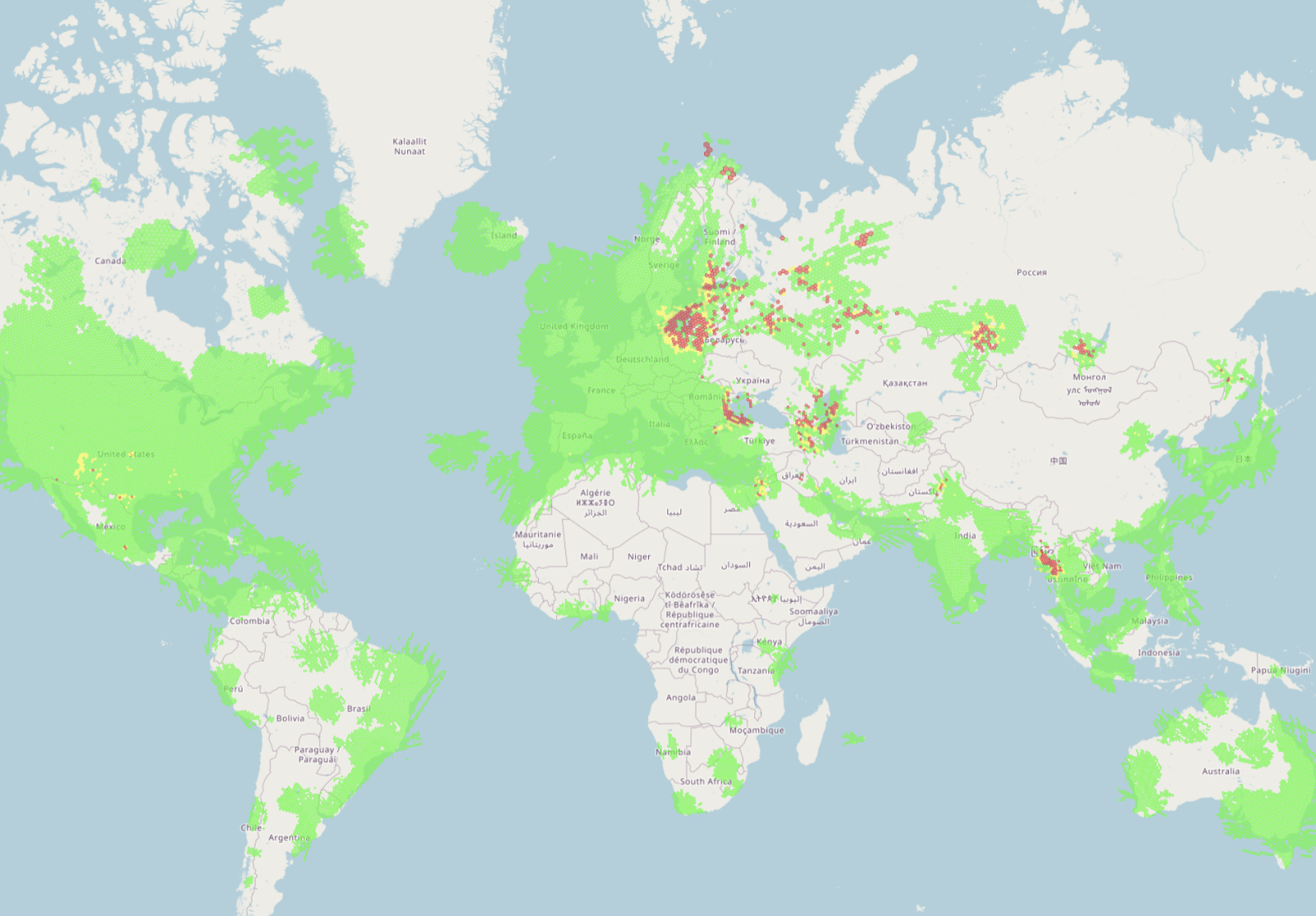
GPSJAM: Daily maps of GPS interference
In affected regions, independent investigative reports have documented sharp rises in interference incidents, with hundreds to thousands reported monthly between 2022 and 2025. For example, sustained interference impacting shipping and aviation in the Baltic Sea region has been attributed by Finnish authorities to coastal jamming operations.
GPSWISE: GPS Spoofing & Jamming Map
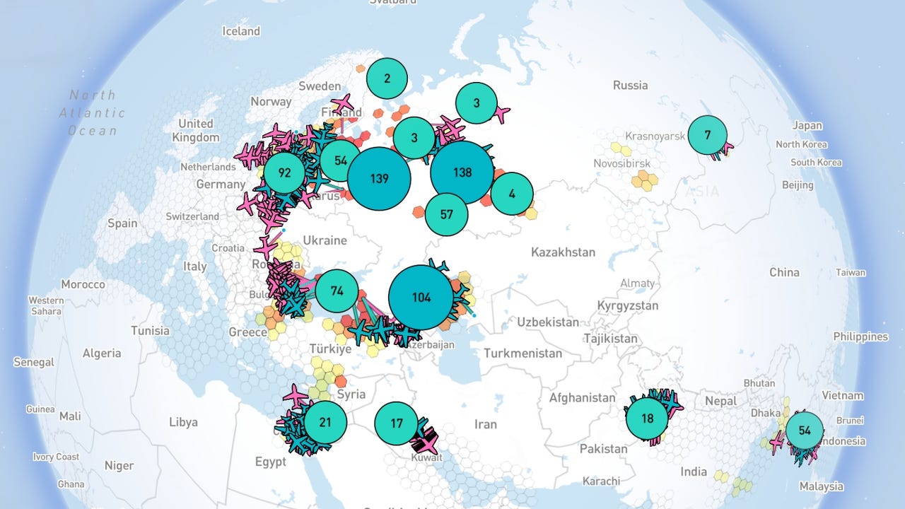
Accessing Real-Time Interference Data and Spatial Monitoring
The geospatial community relies on accurate, timely monitoring. Several maintained portals offer live or near-real-time maps derived from dedicated sensors, crowd sources, and aircraft telemetry. These maps provide the best real-time window into the spatial extent of the phenomenon.
You can link to these platforms to follow the phenomenon:
-
- GPSJAM: Provides daily global maps built from ADS-B/aircraft performance, flagging areas with elevated GPS interference.
- Flightradar24: Features a specialized page that visualizes aircraft GPS accuracy anomalies on a global map with frequent updates.
- Stanford GNSS Interference Map: Offers a research-grade, interactive view showing detected jamming events and associated data resources.
- GNSS Interference Detection using ADS-B: Uses aircraft ADS-B telemetry to detect and visualize potential GNSS jamming or spoofing events on a global scale.
- GPSwise and SkAI’s Spoofing & Jamming Tracker: Platforms that combine ADS-B and other telemetry to flag possible spoofing or jamming affecting aircraft.
Note on Data Limitations: When incorporating these maps into analysis, it is essential to annotate their limitations: detection density often follows air traffic and receiver coverage, false positives can occur, and some advanced military events are intentionally concealed.
Case-studies
In the study “The Vulnerability of Inland Waterway AIS to GNSS Radio Frequency Interference,” the authors carried out lab and live-sky tests on an AIS receiver and found that jamming caused the vessel to completely disappear from other AIS screens, while spoofing made it appear in a false location. Meanwhile, the “GNSS Interference in the Baltic Sea” white paper documents 84 hours of GNSS disruption over a six-month campaign, primarily caused by jamming that degraded positional accuracy from 3–5 m to over 35 m. Together, these cases highlight that GNSS interference can lead not just to loss of signal, but to mis-located assets and corrupted spatial datasets—key concerns for any geospatial data user.
Geospatial Resilience: Practical Defenses for Data Users
Protecting PNT data integrity requires defenses operating at the receiver, system architecture, and procedural levels. For critical infrastructure and high-value remote sensing operations, consider the following technical mitigations:
1. Receiver and Antenna Measures
- Multi-Constellation and Multi-Frequency Receivers: Using satellites across systems (GPS, Galileo, GLONASS, BeiDou) and multiple frequency bands significantly raises the cost and complexity required for an attacker to achieve effective interference.
- Signal Authentication: The adoption of authenticated civil signals, such as Galileo OSNMA, enables receivers to cryptographically verify signal origin and integrity, materially raising the security bar against spoofing.
- Antenna Design: Using directional and adaptive antennas (Anti-Jam filters and antenna arrays) can suppress the power of local jammers or detect anomalous angle-of-arrival patterns consistent with a localized spoofing threat.
2. System and Architecture Resilience
- Alternative Timing and Fallback Sources: Critical systems must maintain system resilience via redundancy. This includes using holdover clocks (oscillators disciplined during GNSS availability) and integrating alternative time sources (e.g., PTP over fiber or eLoran where available) to reduce single-point failure risks.
- Integrity Monitoring and Cross-Checks: Implement monitoring functions like RAIM/ABAS-like integrity monitors. For mobile assets, cross-checking GNSS output against complementary sensors, such as Inertial Measurement Units (IMUs), odometry, or network-based location data, is vital to detect inconsistent GNSS outputs and trigger fail-safe modes before corrupted data is accepted.
3. Operational Awareness
- Operators should utilize the live maps listed above to avoid or react to current hotspots.
- Maintain open lines of communication with national GNSS service centers for timely incident reporting and advisories, which is critical for improved situational awareness.
Summary: Impact on geospatial data accuracy
When jamming or spoofing attacks target GNSS, the integrity of geospatial data is compromised in two ways. With jamming, the receiver may lose lock on satellites, resulting in missing or highly degraded position/time outputs. This can stop remote-sensing missions, derail timing networks, or corrupt positional metadata. Spoofing is even more insidious because the receiver continues to deliver a (false) position or time. For geospatial practitioners, this means: imagery or sensor data stamped with incorrect coordinates or times, mapping layers misaligned, navigation or surveying assets reporting wrong locations, or networks relying on accurate timing drifting unnoticed. Even if the error is small, accumulation of mis-located features or mis-timed events can lead to incorrect analyses (for example, in change detection, precision agriculture, infrastructure monitoring).
Did you like the article? Read more and subscribe to our monthly newsletter!


#GeoDev
Next article


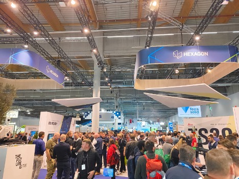
When I arrived at Messe Frankfurt early on October 7th, the energy around Hall 12 was already electric. Groups of engineers and surveyors gathered over morning coffee. Drone operators carried sleek equipment cases, and the sound of rolling crates and echoing metal filled the hallways. That mix of excitement and precision could mean only one thing. Intergeo had begun.
For anyone new to the event, Intergeo is not just another trade fair. It is one of the most important gatherings in the geospatial world, bringing together surveyors, data scientists, government agencies, and companies that work with location-based technology. The story of Intergeo began in 1994 in Mainz as a smaller professional event. A year later, it officially launched in Dortmund with 185 exhibitors. Since then, it has grown into the largest international platform for geodesy, geoinformation, and land management.
The event is organized by DVW e.V. – the German Society for Geodesy, Geoinformation and Land Management, which has been guiding the geospatial profession in Germany for decades. Intergeo is their flagship contribution to the global community, connecting academia, business, and policymakers under one roof. It is where the traditional surveying world meets the fast-changing landscape of digital technology.
This year, Intergeo 2025 returned to Frankfurt, a city known for its international character and innovation-friendly spirit. The event was divided into two main parts: the Conference and the Expo. The Conference featured presentations, discussions, and panels on themes such as digital twins, climate adaptation, AI in mapping, and sustainable land management. It is where ideas and strategies are debated, often by researchers, policy makers, and thought leaders.
The Expo, on the other hand, is where those ideas take shape. It is a hands-on space where technology comes alive. Hundreds of companies fill the exhibition halls with drones, mapping systems, sensors, and software demonstrations. It is the side of Intergeo where you can touch the technology, talk directly to engineers, and see the future in motion.
During my visit, I focused entirely on the Expo. That was where I wanted to spend my time, among the machines, prototypes, and innovators who are building the next generation of geospatial tools. Hall 12 alone hosted more than 530 exhibitors from over 100 countries, covering everything from surveying instruments and GNSS receivers to fixed-wing aircraft designs, reality capture systems, and complete geospatial software ecosystems.
The theme this year, “Using Geointelligence. Shaping the Future,” captured the mood perfectly. The industry has clearly moved beyond just collecting data. The real focus now is on understanding and applying that data to make smarter decisions. Every booth, from established leaders to small start-ups, seemed to echo the same message: it is not about how much data we can gather, but what we can do with it.
The Expo floor was a maze of innovation. Each turn revealed something different: drones that could scan forests in minutes, total stations that could sync directly to digital twins, handheld devices that turned ordinary phones into mapping tools, and AI-driven software that could analyze satellite imagery in seconds. It was a living, breathing snapshot of an industry in transformation.
As I walked deeper into the hall, notebook in hand, I felt the same curiosity that must have filled those first visitors in Dortmund thirty years ago. Intergeo may have changed in scale and technology, but its purpose remains the same: to bring together people who want to understand the world better through data, and to turn that understanding into action.
That was exactly what I came to explore.

One of my first stops at the Expo was the NV5 Geospatial booth. That is where I met Dr. Thomas Bahr, Senior Solutions Engineer, who introduced me to something called the GeoAgent.
He explained that it was designed to simplify complex geospatial analysis. Instead of manually setting up a long workflow, users could simply describe their task in plain language. To show me how it worked, we ran a small test: finding ore deposits for a specific element in a region.
Within a few prompts, the system produced a raster map and a vector mask predicting the ore’s location. When compared to results from the traditional ENVI method, the match was nearly perfect. The GeoAgent runs on ENVI in the background but feels far more intuitive.
What stayed with me was how easily this tool turned expertise into simple dialogue. It did not replace professional knowledge; it made it more usable. That short demo captured what Intergeo 2025 was all about: making spatial intelligence faster, more accessible, and ready for real-world decisions.
Conversations Across the Floor
Geoplex: Making Geospatial Work for Everyone
My next stop was Geoplex, a company focused on software and data management. Their team explained how they have built an entire ecosystem around accessibility. Their tools combine storage, visualization, and analysis through their own APIs, but what stood out to me was how simple everything looked.
One of the engineers told me, “Even someone without a technical background should be able to make sense of spatial data.” Their platform supports fields like hydrology, transportation, and land management, allowing cities and national agencies to use geospatial information without heavy training. It was a refreshing example of technology designed with people in mind.
Vexcel Imaging: Precision That Lasts
At Vexcel Imaging, I saw two new aerial cameras, the Dragon 4.2 and Merlin 5.0, which form their new Signature Line. These models replace the well-known Eagle system and continue the company’s reputation for precision imaging.
The Vexcel team shared something honest and interesting: their cameras last so long that selling upgrades has become a challenge. Still, they are far from standing still. They are investing in an internal AI lab to improve object detection and analysis and developing new APIs that connect their Data Viewer software directly to their imagery systems. The idea is to combine long-term reliability with smarter data processing.
AI- INFRA Solutions: The Ambition of SPATIALL
Further down the hall, I met the team from AI- INFRA Solutions. Their main product, SPATIALL, is an end-to-end geospatial suite that handles everything from data ingestion to analytics and visualization.
Their ambition is global. They want to create a platform that provides high-quality geospatial data and analysis for industries ranging from urban development to resource management. Their biggest challenge, they said, is finding reliable local partners and data providers in every region they enter. It was interesting to hear how many companies are thinking beyond national boundaries now, aiming to build truly international systems.
Bentley Systems: Turning Data into Living Models
At the Bentley Systems booth, I met Stefan Meltzer, Partner Manager for Europe. He shared how Bentley’s ongoing integration with Cesium is helping the company push deeper into data fusion and digital twin technology.
Bentley’s vision of the digital twin is not just a 3D model of infrastructure but a constantly updating ecosystem that brings together reality capture, engineering design, and analytics. Stefan explained how new AI-assisted features are now appearing in MicroStation, allowing users to automate parts of their workflows simply by typing a prompt. Behind the scenes, the software can generate Python code or execute data processing tasks automatically.
It was exciting to see such innovation inside one of the oldest and most respected infrastructure software platforms. Yet Stefan also mentioned a very human challenge: convincing clients to trust cloud-based solutions and shared data environments. Security concerns and market uncertainty still make some decision-makers hesitant, but the potential benefits are too significant to ignore.
Bentley’s direction showed me that the digital twin conversation has matured. It is no longer about making perfect 3D replicas of cities but about maintaining useful, up-to-date digital environments that help engineers, governments, and citizens make better decisions.
Geoautomation: Competing Through Vision
At Geoautomation, I learned about their pioneering work in image-based mobile mapping. Their technology focuses on extracting 3D information from high-quality imagery rather than relying entirely on LiDAR. It is a clever and efficient approach that can deliver strong results at a lower cost.
The team admitted that competing with large LiDAR-based companies can be difficult, but they remain confident in their model. They believe image-based systems still have a big role to play, especially in urban and industrial mapping where flexibility and cost matter. Watching their demo reminded me that innovation often thrives in these in-between spaces, where teams rethink established methods rather than trying to replace them outright.
FlyPix AI: Bridging the Gap Between AI and People
My next stop was FlyPix AI, where the team was passionate about making artificial intelligence understandable and usable. Their main goal is to make AI-driven geospatial tools approachable for non-technical users.
They told me their biggest challenge is helping clients grasp what is truly possible with AI. Many people still view it as something abstract or overly complicated. FlyPix is trying to change that by simplifying the user experience and designing interfaces that speak the language of planners and analysts, not programmers.
Their honesty was refreshing. They acknowledged that AI in geospatial analysis is powerful but often misunderstood. Their focus on usability rather than pure automation felt like a sign of maturity in the industry.
ESRI: AI You Can Train Yourself
At the ESRI Deutschland booth, I met Matthias S., a Sales Engineer who walked me through their new AI features. ESRI’s platform now includes a growing library of pretrained deep learning models that can be updated regularly or fine-tuned with a user’s own data.
Matthias showed how these models make it easier to identify features in imagery, detect changes, or even classify land cover automatically. What stood out was how flexible the system has become. Users can mix global models with local datasets, creating AI that learns context rather than just patterns. It was a reminder that while ESRI remains a giant in the GIS world, it continues to evolve with the times.
UP42: The Marketplace for Earth Data
The team at UP42 described their platform as a kind of “data supermarket” for geospatial users. Through one interface, clients can order satellite, aerial, and drone data from multiple providers. Their customers range from government agencies to private companies that rely on fast, reliable data access.
What impressed me was how transparent the process was. You can not only choose the data source but also chain it directly to processing algorithms. UP42 plans to expand these capabilities, adding more analytics tools and AI-based automation. It felt like the next logical step in making data accessibility as easy as buying an app.
IABG: Finding History Hidden Underground
One of my most memorable conversations was with Ms. Sabrina Korzetz, Project Manager at the Geodata Factory of IABG in Dresden. She explained their fascinating work on detecting unexploded ordnance (UXO) using historic aerial imagery.
They combine archival photos with modern analytics to locate remnants of wartime munitions that still pose risks underground. Listening to her describe the process was like hearing history meet data science. It showed that geospatial analysis is not only about the future. Sometimes it helps us understand the past to make the present safer.
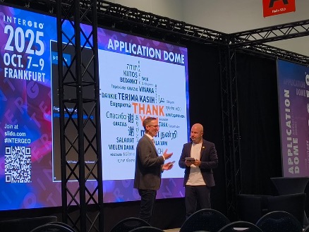
Lessons from the Application Dome
Between meetings, I attended a few sessions in the Application Dome, a part of the Expo focused on practical use cases.
One of the standout talks came from Airbus, which presented its Earth Model initiative. The project aims to create detailed, AI-enhanced 3D models of the planet. Initially, the goal was to map the entire world, but the team quickly realized the scale was enormous. They now focus on selected cities like Dubai and Cape Town and plan to expand gradually. The process combines satellite imagery, 3D reconstruction, and AI-based automation. The results were visually stunning and demonstrated how close we are to a unified digital Earth.
Another interesting session focused on Parcel Fabric technology, which uses a service-oriented architecture to improve land management systems. It may sound technical, but the potential impact is huge. Digital parcel management could make ownership mapping and infrastructure planning faster, more transparent, and less prone to error.
A third session introduced Project AURA, a navigation app created to improve safety for women. It integrates spatial data and AI-based routing to identify safer paths in real time. It was inspiring to see geospatial technology being used for social good, reminding everyone that behind the data and algorithms are people who can benefit directly from these innovations.
By the final afternoon, I felt both tired and inspired. Intergeo 2025 had filled my notebook and my thoughts with ideas about where the industry is heading. It was not just a display of new machines or clever software. It was a snapshot of how the geospatial world is learning to connect information, technology, and people.
One clear change was how geospatial tools are now seen as an everyday necessity rather than a specialist resource. The technology is spreading across professions. City planners, environmental scientists, and infrastructure managers all expect to use spatial data in their work. Many companies at the Expo were building tools that make this possible, focusing on design, accessibility, and simplicity instead of complexity.
I also noticed a shift in what people value. Precision is still important, but the real innovation now lies in understanding context. The new generation of platforms connects multiple data types, such as satellite images, elevation models, and climate data, to create insights rather than just visualizations. The focus has moved from showing the world accurately to explaining how and why it changes.
Another strong theme throughout the Expo was scalability. While massive digital twin projects and global mapping programs remain impressive, many exhibitors were creating smaller and more flexible systems for mid-sized cities, local governments, and private companies. These solutions are affordable, maintainable, and designed to work with existing infrastructure. This approach will make geospatial intelligence more accessible to a wider community.
Conversations around trust and data governance came up again and again. Whether it was about the reliability of cloud storage, the safety of sensitive data, or the ethics of AI-driven mapping, everyone agreed that progress requires clear and consistent rules. The industry is learning that technology alone is not enough. We also need frameworks that ensure fairness, transparency, and accountability.
Looking back, Intergeo 2025 felt like a turning point. The event has grown far beyond its roots as a surveying fair. It now represents a global network of people who are using spatial information to solve problems that affect everyone. From climate resilience to urban design, the applications are expanding rapidly.
As I walked out of Hall 12 for the last time, I looked around at the visitors still talking in small groups, exchanging cards, and making plans. The energy in the room had not faded. It reminded me that Intergeo is more than an exhibition. It is a community that keeps learning, sharing, and shaping the future together.
Intergeo 2025 proved that the real progress in geospatial technology is not about collecting more data. It is about understanding the world more deeply and turning that understanding into meaningful action.
Next year, Intergeo will take place in Munich. I am already looking forward to being there again, ready to see how far this journey of geospatial innovation continues to go.

