
Editor’s Note: This article is part of Geoawesome’s Guest Contributor series, where members of our global geospatial community share their insights and experiences. We believe good ideas get even better when shared. Got your own take on how geospatial, EO, AI, or maps are shaping the world? We’re always looking for fresh voices, drop us a line (info@geoawesome.com) and let’s make the world a little more awesome together.
In the fight against deforestation, land conversion and smallholder exploitation, technology is an incredibly powerful tool.
We’re seeing a huge number of technical tools coming to market, powered by satellite data and AI. They’re empowering organisations and individuals to improve traceability, ensure compliance and drive supply chain sustainability.
In many cases, these platforms are being lauded as all-in-one solutions that will lead to a world where deforestation, environmental degradation and unsustainable practices can be quickly and easily monitored and prevented. The promise is that anyone can now track forest loss, monitor wildfires, or even estimate carbon emissions – without ever having to step foot in the areas they are monitoring.
While the potential of these tools is undeniable (in fact, we offer a tech platform at MosaiX), technology is only one part of a much wider solution, and an over-reliance on data platforms and tools comes with critical limitations and real risks.
In this article, I’ll explain why depending on technology alone is so counterproductive.
The Positive Forces Driving Tech Adoption
I’s important to acknowledge that the widespread adoption of these tools is positive. It’s a sign that an ever-increasing number of organisations are taking their responsibilities seriously and making No Deforestation, No Peat, and No Exploitation (NDPE) commitments.
It also reflects the legislative progress, and the efforts of NGOs and governments to drive sustainable change, through the introduction of landmark legislation like the EU Deforestation Regulation (EUDR).
When used properly, technology tools can provide accessible, effective and accurate monitoring that can provide real insights and accountability. With the right data, high-quality satellite imagery, land ownership mapping and AI pattern recognition, you can gain invaluable insights that can help you to prevent land conversion – and hold those responsible for deforestation to account.
The problem is that getting accurate information is much harder than it seems.
Promise vs. Reality: Data Quality
With technology platforms and AI insights, the outputs are only as good as the inputs, and these are often hampered by significant data quality issues. Information can be inaccurate, outdated, or suffer from a lack of granularity. For instance, most deforestation analysis tools can tell you where deforestation is happening, but not necessarily who is responsible or why.
Another big issue is that many platforms depend on open-source satellite and land ownership data. While this can give the illusion of transparency, it can also be woefully inaccurate!
When data inputs are poor, the outputs follow. Without rigorous verification, contextualisation, and experts on the ground, these tools risk oversimplifying complex situations or, worse, generating misleading conclusions.
Data quality can be particularly poor when it comes to critical information, such as land tenure details, intricate supply chain relationships, and verified corporate ownership structures. This data is often scattered across disconnected systems, difficult to access, or inconsistently formatted, hindering the ability of AI tools and technology platforms to deliver a coherent, accurate and complete picture.
The result is that customers using these tools end up missing relevant deforestation and having to manage a significant number of false alarms! This confusion can be a serious risk for businesses that want to stay compliant or investors looking for protection against greenwashing claims.
The Interpretation Gap: Beyond Pixels and Alerts
Raw data and automated alerts, however sophisticated, can’t understand the full picture. To do that, you need an expert. An alert for tree cover loss, for example, doesn’t inherently distinguish between illegal deforestation and natural disturbances. This “interpretation gap” can further muddy the picture.
There is a crucial, often underestimated, need for expert analysis to dissect the data, understand its nuances, and verify findings on the ground. Local context is essential, and no tech platform can interpret data through the context of unique social dynamics, customary land rights, existing legal frameworks, specific local laws and regulations, and the intricacies of different commodity sectors!
These factors all play a vital role in accurately understanding and addressing sustainability risks. Technology can reveal patterns and present this data, but it cannot, by itself, capture the full picture. That’s where people, systems, and relationships come in. For a complete solution, all data needs to be validated and interpreted with human expertise.
Turning Alerts into Intervention
The next challenge is what companies do with the data they get from the tech platforms. Even when the technology works perfectly and provides an accurate alert, companies often struggle to translate this information into meaningful, timely, and appropriate actions on the ground.
On one hand, there’s the risk of unnecessary supplier exclusion based on incomplete or misinterpreted automated alerts, potentially damaging livelihoods and severing valuable relationships. On the other, failing to respond effectively to deforestation due to a lack of clarity or capacity can mean that destructive practices continue unchecked – causing environmental damage and the reputational damage that comes from it.
To truly address deforestation linked to a specific commodity, you need accurate, up-to-date plantation maps, verified corporate ownership data, and a fully traceable supply chain, from growers to market.
Relationships matter here, and the companies using tech tools need to know who the key decision-makers are within all their suppliers and how to engage with them constructively when problems arise. Technology might be able to identify the issue, but it isn’t going to make the call to the relevant person at the grower to address the issue!
Compliance & Legal Risks
With the introduction of regulations like the EUDR, the Corporate Sustainability Due Diligence Directive (CSDDD), and the Corporate Sustainability Reporting Directive (CSRD), the need for effective due diligence and accurate data is growing.
Superficial reliance on technology platforms and automated assessments is no longer sufficient and exposes companies and investors to significant legal and reputational risks.
The EUDR, for example, demands verifiable proof that products are deforestation-free, including precise geolocation data for plots of land. Companies also need traceable, defensible data and auditable processes as part of their due diligence.
The consequences of non-compliance are high, from warnings and significant fines to potentially being disqualified from the entire market! Traditional methods of supply chain monitoring, like supplier self-reporting and periodic on-site audits, are no longer enough to meet the demands. All issues need to be treated as seriously as any other legal case: carefully documented, evidence-based, and demonstrably compliant with regulatory requirements.
From Greenwashing to Techwashing
We are seeing an increasing number of entities dressing up their sustainability claims with impressive-sounding technological jargon, like “AI-powered”, “blockchain-enabled”, or “satellite-based monitoring”. Without the backing of robust processes, deep-seated expertise, or genuine accountability, this is simply a form of greenwashing! Technology becomes a marketing tool rather than a solution.
Techwashing claims like this risk doing more harm than good. They can create a false sense of security for businesses, who feel like they are ‘covered’ without having to take meaningful action. They can also cause confusion and reputational backlash among investors, regulators, and consumers trying to distinguish real progress from empty promises.
Integrating Technology with Expertise
The true value of tech tools depends entirely on who is using them and how.
To be effective in preventing deforestation, land conversion, and broader environmental, social, and governance (ESG) risks requires the input from a team with the right expertise, systems and resources. This means:
- Prioritising Data Integrity: Moving beyond reliance on unverified open-source information and investing in the verification and contextualisation of local data.
- Bridging the Interpretation Gap: Recognising that technology must be coupled with human expertise – analysts who understand local socio-legal contexts, sector-specific dynamics, and the nuances of corporate structures. Different commodities and regions require tailored approaches – what works for cocoa in West Africa may not work for palm oil in Southeast Asia or soya in Brazil.
- Taking Action: Developing systems for turning alerts into engagement and effective interventions – involving the people that matter.
- Taking Due Diligence Seriously: Moving beyond box-ticking to implement traceable, evidence-based systems that comply with regulations and demonstrate genuine commitment.
- Demanding Accountability: Ensuring claims of “tech-driven sustainability” are backed by tangible processes, proven expertise, and measurable impact.
Creating truly sustainable supply chains requires us to harness the power of technology responsibly. This means acknowledging its limitations, mitigating its risks, and integrating it with the irreplaceable value of human expertise.
By Priscillia Moulin, Co-founder and Director of Strategy – MosaiX – https://mosaix.earth/
About MosaiX
MosaiX is a Netherlands-based company that provides organizations throughout the supply chain with data-driven, real-world solutions for sustainability, compliance, and responsible sourcing.


#Environment

Next article
From Accuracy to Action: How HD Satellite Data and AI Are Revolutionizing Navigation for Emergency Response and Logistics

As our reliance on navigation systems continues to grow, the demand for accurate and real-time data has never been greater. All users of navigation data, be they casual or professional, have come to expect their maps to be accurate, updated, and easy to use, with a matching seamless satellite imagery overlay. However, the importance of accurate navigation systems is most evident in industries where speed of response is critical, like emergency services and logistics. They are essential for moving quickly and safely through changing environments to meet tight delivery schedules or get to people in need; outdated or incomplete data can lead to errors, delays, or even loss of life.
In response to this evolving need, high-definition (HD) maps have become increasingly important for providing precise, relevant information, transforming maps from static objects into a dynamic, near real-time system. However, creating and maintaining these high-precision maps comes with considerable challenges, especially in rapidly shifting urban environments and areas of significant population change.
The Growing Need for Accurate and Up-to-Date Maps
First responders and emergency services often operate in urban environments that are constantly changing—road layouts and infrastructure are in a permanent state of development, and construction zones often pop up with little warning. For a fire truck or ambulance responding to an emergency, a short delay caused by an outdated map can be the difference between life and death—in fact, numerous studies have shown that a response time of mere minutes can have a significant impact on patient survival rates.
Logistics and delivery companies face the same problems, albeit with less dramatic stakes. With the rise of ecommerce and next-day (or same-day) delivery, the logistics industry increasingly depends on efficient pick-up and drop-off to keep deliveries on time and to meet ever higher customer expectations. For example, in an Ipsos survey of 2022, 85% of online shoppers said a poor delivery experience would prevent them from ordering from a retailer again. Small delays can therefore lead to big financial losses.
To meet these needs in today’s fast-paced world, maps need to be updated proactively, rather than reactively. Traditionally, mapping companies have relied on a global network of employees, mobile mapping, and user feedback for generating map updates. Proactive change detection is possible with these methods, but it can be time consuming. Earth observation space-based technology is poised to play a vital role in keeping maps updated by supplementing these data sources with specific areas of change.
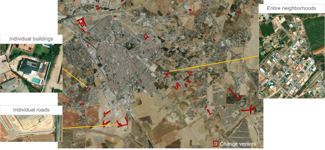
Maxar’s Building and Road Change is a cutting-edge vector product that provides insights on areas with map-relevant change.
The Competitive Edge of Satellite Data in Navigation
Satellite imagery has been providing context for navigation systems for many years, offering a broad view of the Earth but without the granular detail needed for real-time decision-making. However, this is rapidly changing: “Satellite data has evolved from being a static backdrop to a dynamic, integral part of mapmaking,” says Luca Perletta of Maxar, a leading provider of secure, precise geospatial insights. “With the latest advancements, we can now detect changes in infrastructure almost in real-time, allowing us to keep maps updated with unprecedented accuracy.” By facilitating the move from reactive mapping to proactive updates, satellite imagery, supported by artificial intelligence (AI), is redefining the mapmaking process, enabling maps to be updated dynamically and on a larger scale than ever before.
Maxar’s constellation of very high-resolution satellites is playing a critical role in this transformation. They have the ability to collect 30 cm-class resolution imagery—which can be further enhanced to 15 cm HD using super resolution models. As Maxar’s Josh Winer notes, “15 cm satellite imagery offers a level of detail that was previously only achievable with aerial photography.”
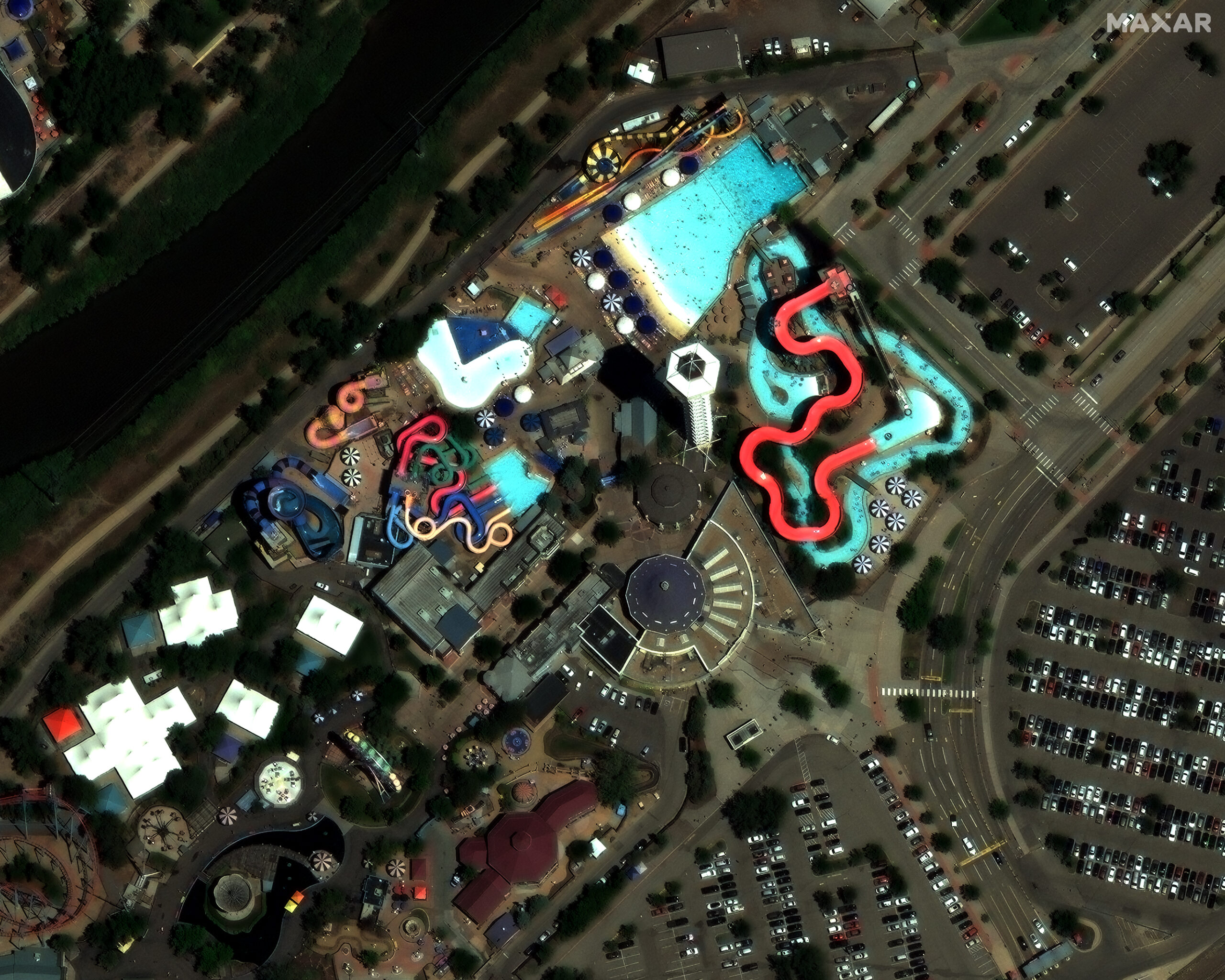
This Maxar satellite image of Denver, Colorado, in 15 cm HD resolution shows incredible details such as sidewalks, individual parking spaces, theme park structures, and even people enjoying the swimming pool.
Satellite imagery can be used to identify construction zones and other infrastructure changes in near real-time. Significantly, it can also identify the extent of road closures and other features not visible from common conventional sources like dash cams. This level of speed and precision “is essential for identifying road features and environmental changes that are critical for the safe operation of emergency services,” says Winer. It also improves efficiency for logistics companies.
Proactive Change Detection: Crucial for Navigation Systems
In the words of Perletta, “The future of navigation services lies in our ability to anticipate and adapt to changes in the environment.” As urban landscapes rapidly evolve, the ability to detect and anticipate changes before they impact navigation systems is increasingly critical, and satellite data, augmented with AI, offers a powerful solution through proactive change detection.
Maxar’s system uses AI change detection models to constantly analyze a feed of low resolution satellite imagery, identifying any changes that occur. When changes are detected in an area of interest, Maxar tasks its very high-resolution satellites to collect fresh imagery of the area to confirm and provide additional details about the change.
“The integration of high-resolution satellite data with AI-driven analytics is revolutionizing the way we create and maintain maps for navigation,” says Winer. It allows mapmakers to proactively adjust to new developments—detecting new roads, bridges or buildings before they have been completed. “This proactive approach is crucial for ensuring that navigation maps are as accurate and up to date as possible.”
This is a game-changer for navigation systems used by emergency services or logistics. It ensures that any user of navigation information, whether a fire truck navigating through new neighborhoods or a delivery driver rerouting around construction zones, always has access to the most current data, significantly reducing the risk of delays or errors during their operations. Moreover, the ability to provide additional contextual information, such as up-to-date details on urban development or environmental hazards, adds an extra layer of intelligence to navigation systems, improving safety as well as efficiency.
Next-Generation Navigation Systems
The integration of high-definition satellite data and AI is paving the way for the next generation of navigation systems. With proactive change detection and dynamic updates, these tools have the potential to provide industries like emergency response and logistics with a radically improved driving and navigation experience. By reducing the reliance on manual change detection techniques and introducing a real-time approach to mapmaking, they will be able to operate more efficiently and safely than ever before, while also saving valuable resources. From emergency services reaching critical locations faster to delivery companies optimizing their routes with unprecedented accuracy, the future of navigation lies in this powerful combination of technology.
However, these are far from being the only sectors to benefit from these technological developments. Indeed, any company, service provider or industry looking to remain competitive should be exploring the different ways in which satellite imagery and AI can be harnessed to improve their navigation systems and improve efficiencies, ultimately benefiting end users and customers. The continued advancement of satellite data, combined with AI, holds the potential to revolutionize navigation systems in more ways than we can yet imagine.
Learn more about Maxar at www.maxar.com

