

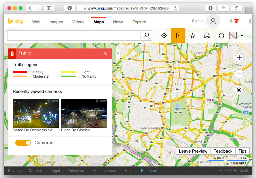
Microsoft haven’t said the last world with regards to Bing Maps yet. In June the company sold its own „Street View” department to Uber. At the same time Microsoft introduced tge brand new, redesigned version of its mapping service. It’s terribly slow but the new design looks and feels cool and modern. Microsoft is clearly searching for a niche that could help it win even a tiny part of the web maps industry ruled by Google, Apple and OpenStreetMaps. Last week the company has added a new feature which might help to reach that goal – live stream from traffic cameras.
The idea of traffic cams on a map comes back to the mid 2000s, when there was no better traffic information available. Today no one else has this feature as users prefer to get pre-interpreted results right away in the form of colorful stripes. Looking at images from cameras along your route is simply not intuitive and time-consuming. Nonetheless there might be a group of users who are missing that feature and prefer to check the traffic on their own rather than to fully trust machine-generated traffic flow data based on probes.
For the start Microsoft will add images coming from over 35,000 cameras in 11 countries. And there might be a method in that madness…
There is however one obstacle that might successfully stop users from using it. After couple of minutes you need login via your Microsoft account in order to view traffic cam streams. Too bad mr Satya Nadella…


#Insights

Next article
Couple of months ago Google introduced the News Lab, a new program to empower innovation at the intersection of technology and media. In order to do that Google has been releasing many cool datasets on Google Trends Datastore.
One of such an datasets (not yet available in the datastore) has been used by Google’s data editor Simon Rogers, who made a map and a visualization of flights that originated from the US on November 25 and 26, 2015. The map shows domestic and international flights that have been booked via Google Flights. The flights are color coded by airline.
The map uses CartoDB mapping engine.
source: Mashable

