
For most of human history, maps were made for people. They were visual, interpretative, and selective. A cartographer decided what to show and what to hide. Abstraction was not a limitation, it was the essence of the craft. But something fundamental is changing.
Today, some of the most advanced maps in the world are not designed to be read by humans at all. They are built for algorithms.
This shift, from human-oriented cartography to machine-oriented spatial infrastructure, is at the heart of a fascinating research paper by Prof. Dariusz Gotlib, a leading Polish cartographer, my scientific mentor, and a long-time family friend along with Prof. Georg Gartner (President of ICA) and Krzysztof Miksa (long-time employee of TomTom and Stellantis). Their recent publication, “HD Maps for Autonomous Vehicles: Implications for Cartographic Theory and Practice,” asks a deceptively simple question:
What happens to cartography when the primary user of the map is no longer a human, but a machine?
From Navigation Maps to Machine Maps?
Traditional navigation maps, whether paper atlases or digital road maps, were designed to support human cognition. Even Google Maps, despite its algorithmic backend, ultimately presents a visual representation optimised for human perception.
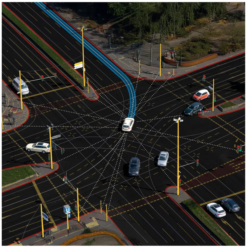
HD (High-Definition) maps are different. They operate at centimetre/decimeter-level precision. They include:
- Exact lane geometries
- Road curvature and elevation
- Sign and signal locations
- Curbs, barriers, guardrails
- Semantic attributes relevant for driving decisions
They are not meant to be looked at. They are meant to be computed.
For autonomous vehicles, HD maps serve as a prior model of reality — allowing the vehicle to localise itself precisely, anticipate road features beyond sensor range, and make safe decisions. Sensors perceive the present. HD maps provide structured spatial memory.
And this is where the argument becomes powerful. The paper suggests that HD maps are not just a new product category. They represent a paradigm shift in cartography itself.
When Abstraction Changes Meaning
In classical cartography, abstraction was about simplification. You generalize features to make them readable at different scales. In HD maps, abstraction serves a different purpose. It is not about visual clarity. It is about machine interpretability.
Instead of symbolization for human eyes, we now design data structures optimized for algorithms. Instead of choosing colors and line weights, we define semantic layers and topological relationships.
The map becomes:
- A spatial database
- A structured model of the road environment
- A component of an AI system
Cartography shifts from visual communication to spatial systems engineering.This challenges long-standing definitions of what a map actually is.
Is a map still a map if it is never seen?
HD Maps as Infrastructure
Another important insight from the paper is that HD maps should be treated not as static products but as dynamic infrastructure.
Autonomous driving requires continuous updates:
- Roadworks
- Temporary closures
- Construction changes
- Updated traffic patterns
HD maps are therefore:
- Versioned
- Continuously maintained
- Integrated with real-time sensor feedback
In many ways, they resemble digital twins of road networks. And this is where the topic goes far beyond autonomous vehicles.
HD maps are becoming foundational layers for:
- Smart mobility ecosystems
- Cooperative perception between vehicles
- Urban traffic optimization
- Future AI-enabled infrastructure systems
The implications for geospatial professionals are enormous.
A Blind Spot in Cartography?
Despite their growing importance in industry, HD maps have received relatively limited attention within traditional cartographic theory. This gap is precisely what the paper addresses.
It argues that the academic field of cartography should not leave HD maps entirely to automotive engineers and AI developers. Instead, cartographers bring unique expertise in:
- Spatial abstraction principles
- Representation models
- Data harmonization
- Multi-scale thinking
- Conceptual frameworks of space
In other words:
Cartography still matters — perhaps more than ever. But it must evolve. The question is:
Are we witnessing the redefinition of cartography itself?
The paper suggests that we are.
Maps are no longer only communication tools.
They are operational components of intelligent systems.
For those of us working at the intersection of drones, Earth observation, AI, and geospatial technologies, this shift feels familiar. We are increasingly building spatial datasets not just for visualisation, but for automation. And that is a different mindset. We are not abandoning human-centric maps.
Instead, we are entering a hybrid era:
- Maps for people
- Maps for machines
- And increasingly, maps for both simultaneously
The future likely lies in interoperable systems where HD maps, digital twins, and human-oriented interfaces coexist.
But recognizing this transformation is the first step.
Final Thought
HD maps are more than detailed road datasets. They are a signal that cartography is entering a new phase, one where maps are no longer primarily visual artifacts but active, machine-interpretable infrastructures shaping how autonomous systems perceive and navigate the world.
For geospatial professionals, this is not a niche topic.
It is a strategic frontier.
And it is only the beginning.


#Deep Tech


Next article
Melting ice sheets, precision agriculture, and satellites that operate during the night all point to the same shift: AI-powered geospatial technologies are changing how we observe, interpret, and safeguard the planet.
A Planet Under Pressure
As 2026 begins, geospatial technologies are forming a new “nervous system” for Earth, combining high-resolution satellites, AI, and digital infrastructure to track environmental change in real time.
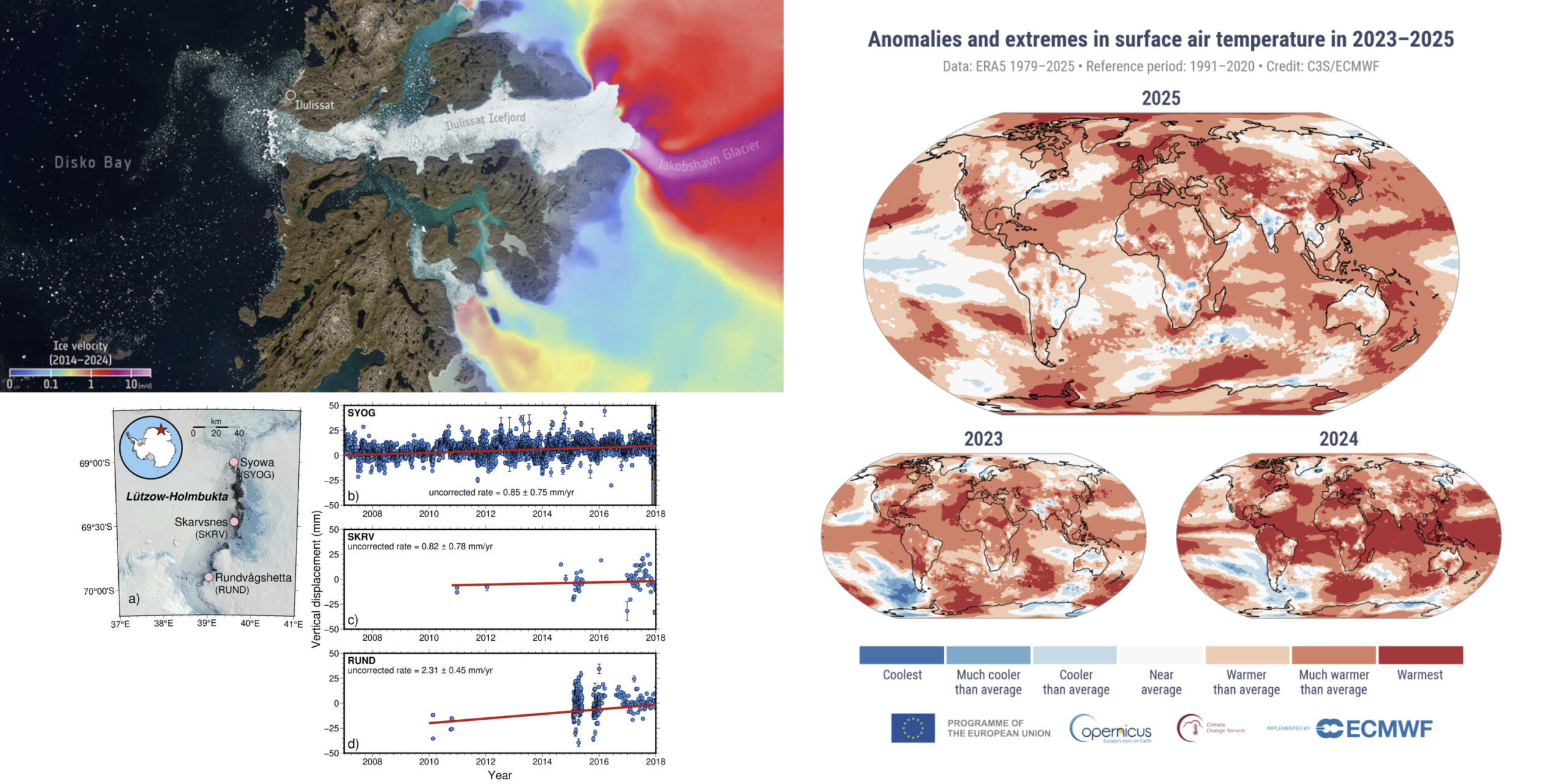
Data from the Copernicus Climate Change Service confirm 2025 as the third warmest year on record, with global temperatures 1.47°C above pre-industrial levels, and 2023–2025 marking the first three-year stretch above 1.5°C. The Arctic recorded its second-warmest year, while Antarctica reached its highest annual temperature.
Sentinel-1 satellites have provided a decade of detailed ice-flow data across Greenland and Antarctica, revealing complex dynamics. The East Antarctic Ice Sheet thinned rapidly thousands of years ago but has since re-thickened by up to 100 meters – with further context available via The Brighter Side – refining projections for future sea-level rise.
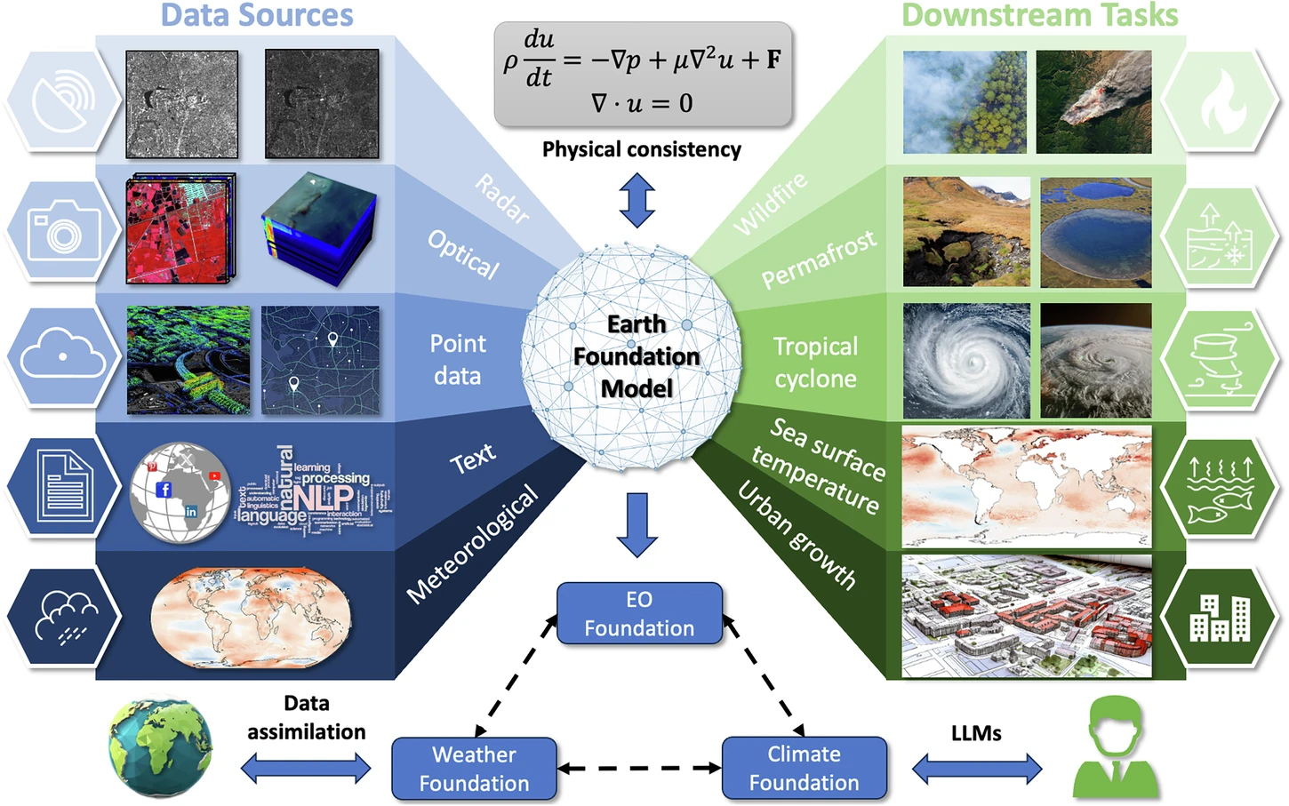
Earth Foundation Models and the Age of Spatial AI
The tools used to interpret these changes is evolving into a planetary infrastructure. The global geospatial intelligence market is projected to grow from $37.13 billion in 2025 to $62.88 billion by 2030. This growth is fueled by “GeoAI” platforms that enable automated image interpretation and predictive spatial analytics.
Central to this progress is the development of Earth Foundation Models. These AI models, documented in a recent study in Scientific Reports, are designed to be task-agnostic, learning general representations from vast reservoirs of unlabeled satellite and climate data. By prioritizing carbon-minimized operations and physical consistency, these models aim to bridge the gap between Earth observation and climate science.
Zhu, X.X., Xiong, Z., Wang, Y. et al. On the foundations of Earth foundation models. Commun Earth Environ 7, 103 (2026). https://doi.org/10.1038/s43247-025-03127-x
Tools in Practice: Precision Agriculture and Urban Growth
Mainstream Agriculture
By 2025, over 85% of precision agriculture projects used remote sensing. Platforms like Farmonaut leverage multispectral imagery to help farmers achieve up to 30% water savings through precision irrigation and early pest detection.
Mapping Global Growth
Researchers from the Chinese Academy of Sciences recently released a high-resolution global dataset mapping city and town boundaries from 2000 to 2022. This offers evidence for monitoring urban expansion and guiding sustainable land-use planning. Accompanying tools such as ArcGIS Pro and ArcGIS StoryMaps are helping analysts communicate these findings visually.
Daily Navigation
Geospatial tools have also reached consumers directly. Google and Apple Maps now use motion-based sensors and Bluetooth to automatically save parking spots on iPhones, ensuring users never lose their vehicles in crowded lots.
Innovation in the Dark and Digital Twins
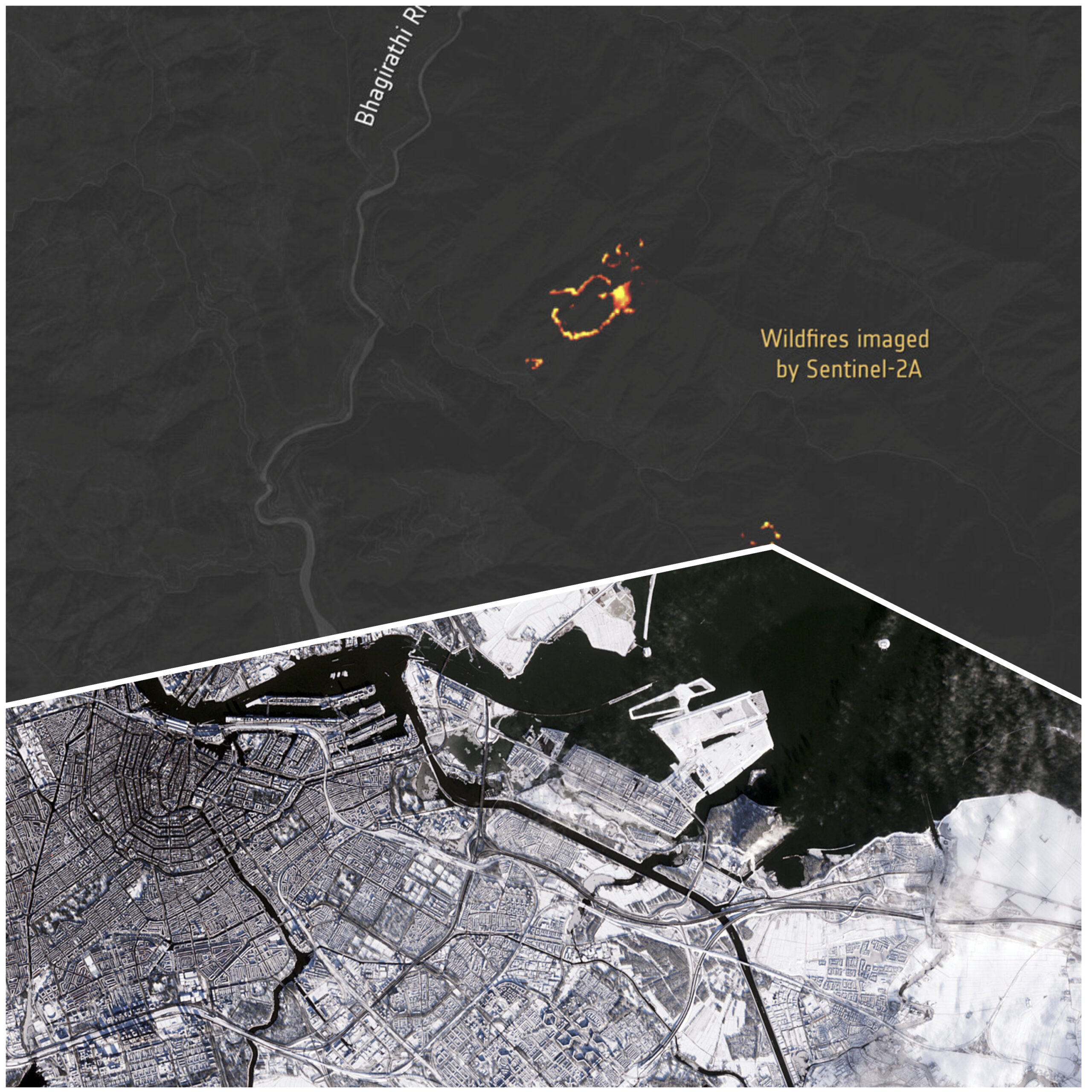
Even as the sun sets, the “eyes in the sky” remain active. The Copernicus Sentinel-2A satellite has successfully tested “night vision” capabilities, capturing imagery of gas flares in the Middle East, wildfires in India, and fishing boats off South Korea during night-time passes. A striking example of its daytime imagery also surfaced recently, with snow-covered Amsterdam captured in stunning detail from orbit.
Innoviz Technologies recently announced InnovizThree, a sensor-fusion module that combines long-range LiDAR with an RGB camera. This allows for colored 3D point clouds, purpose-built for drones and micro-robotics used in environmental monitoring. For those exploring drone alternatives following potential DJI market changes, the sensor landscape is expanding rapidly.
Meanwhile, a detailed guide to Inverse Synthetic Aperture Radar illustrates how these techniques – once military-grade – are crossing into civilian Earth-monitoring applications. The Copernicus Emergency Management Service also continues to provide rapid mapping activations for disasters worldwide.
AI Agents
AI is extending its influence beyond traditional Earth observation. he mining sector is exploring the role of AI agents in mineral exploration and processing – a field with significant geospatial overlap. Competitions like IEEC’s Earth Observation use-case ideas competition are also accelerating private-sector innovation. Community tools like open-source GIS workflows shared by researchers on social media are democratizing access to these capabilities.
A Collaborative Future
While the tools of the trade are shifting – evidenced by the closure of the nearly 37-year-old The Earth Observer newsletter in late 2025 – the mission of Earth stewardship is only expanding. New collaborative platforms like the Digital Space Ecosystem are connecting space actors and research organizations across Europe to share capabilities.
The history of cartography itself is being revisited. Ongoing debates about map projections – including the famous Mercator distortion of Greenland’s size – remind us that how we visualize the Earth shapes how we understand it. The history of cartography stretches back centuries, now accelerating into the digital age.
As we look toward 2026, the goal is clear: to move from simple observation to actionable intelligence. By integrating historical records – such as the newly scanned 18th-century wall maps at the Library of Congress – with real-time QGIS Python plugins for flood mapping and AI-driven analysis, we are building a more resilient and sustainable future. Informative video overviews, such as this tutorial of NASA Commercial Satellite Data Acquisition (CSDA) and this demonstration of GeoDelta Labs on flood mapping, are also helping practitioners get up to speed quickly.
The revolution, it turns out, is also open-source. Free tools like TVStudy and QGIS already allow anyone to map signal coverage and visualize spatial data at professional quality — a reminder that the most consequential changes in how we see our planet are not always driven by billion-dollar satellites, but sometimes by software anyone can download for free.
Did you like the news roundup? Read more and subscribe to our monthly newsletter!

