Making AI Work with Discrete Global Grid Systems

- Geospatial data has grown in volume and complexity, but most AI systems still struggle to use it in a meaningful way. A recent line of work connects Earth observation data with machine learning models through Discrete Global Grid Systems (DGGS). The approach is known as AI-DGGS.
The Open Geospatial Consortium (OGC) recently completed a pilot project, “AI-DGGS for Disaster Management.” The project tested whether AI systems can work with standardized spatial data in a way that supports real decision-making during events such as floods. Instead of treating maps as images or loose coordinate pairs, the system used grid cells as the basic unit of reasoning. This allowed the models to query and combine spatial data in a consistent way.
This article explains what DGGS is, why it matters for AI, and what the OGC pilot showed in practice.
What is DGGS?
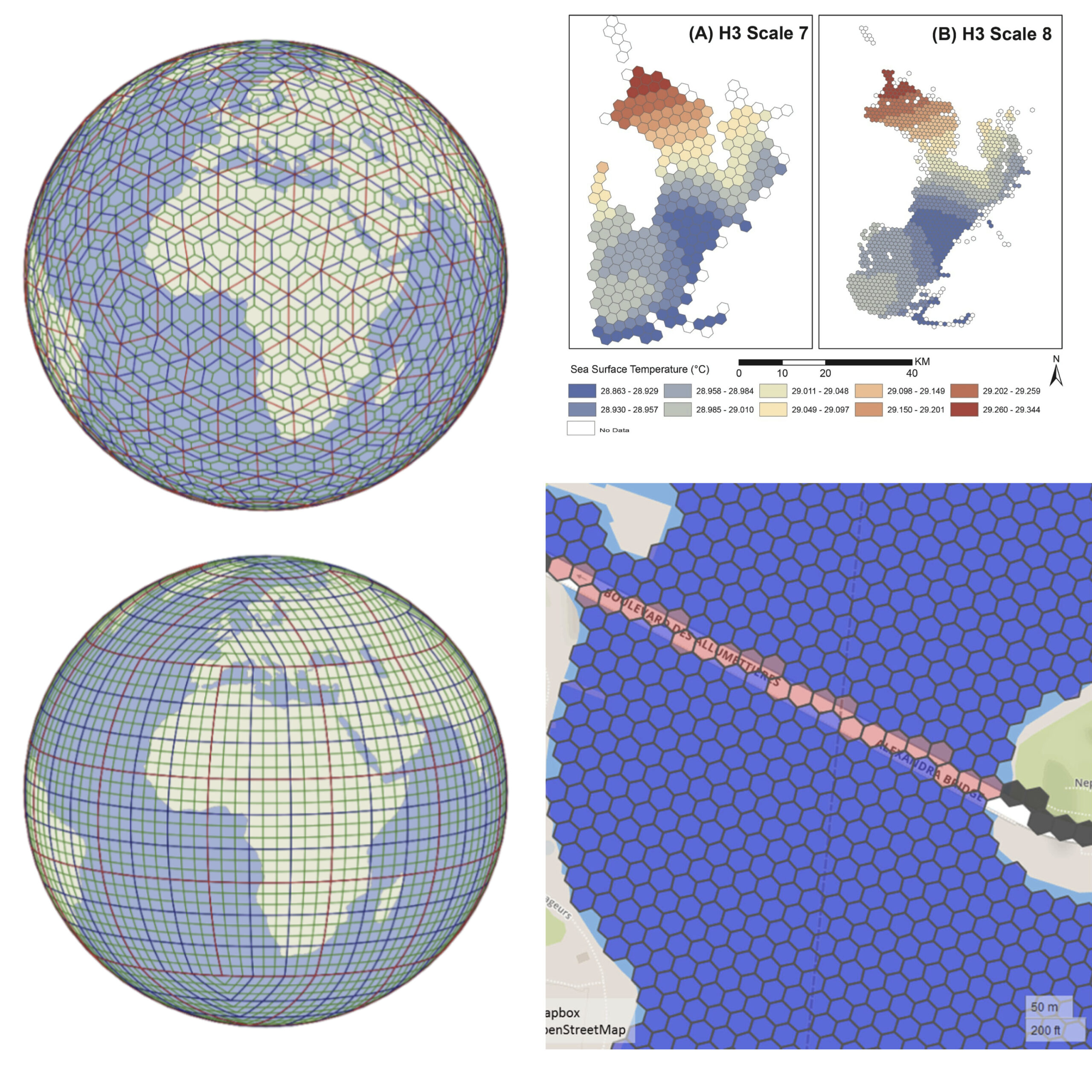
DGGS stands for Discrete Global Grid Systems. In basic terms, a DGGS is a system that turns the Earth into a digital “mosaic” or “spreadsheet.” Instead of looking at the world as a flat map with complex coordinates (like Latitude 49.8951, Longitude -97.1384), a DGGS divides the entire planet into a grid of fixed cells. Think of it like pixels on a computer screen or tiles on a floor, but wrapped perfectly around the globe.
Why DGGS Exists
Most GIS workflows grew out of paper maps and projected coordinate systems. These projections distort distances or areas, and combining datasets often means handling mismatched rasters, vectors, and reference systems. Anyone who has tried to align satellite imagery with road networks knows how much manual work this can involve.
A DGGS takes a different approach. The Earth is divided into a hierarchy of uniform cells, commonly hexagons, triangles, or squares. Each cell has a stable identifier and a well-defined spatial extent. Data from different sources can be stored and queried using these shared cells rather than raw coordinates.
Key Properties of DGGS
In practice, DGGS brings three useful properties:
| Concept | Description |
|---|---|
| Common Spatial Frame of Reference | DGGS models the Earth as a sphere covered in discrete cells, forming a unified digital grid. Each cell acts like a row in a global spreadsheet, allowing diverse datasets – such as weather, population, infrastructure, temperature, flood depth, or roads – to align seamlessly without reprojection. |
| Stable Cell Identifiers (Spatial Tokenization) | Each cell has a unique identifier or “ID,” serving as a spatial token. These IDs replace floating-point coordinates, simplifying indexing, joins, and data integration. This approach allows computers and AI systems to process spatial data as easily as text tokens. |
| Equal-Area Cells | DGGS maintains consistent cell areas across the globe, eliminating distortions found in traditional map projections. Equal-area cells ensure that statistical and scientific analyses remain accurate, as a cell in one region represents the same surface area as a cell elsewhere. |
| Hierarchical Grid Structure | DGGS grids are hierarchical, with parent and child cells. Larger cells represent broader regions, while smaller cells provide finer detail. This structure supports multi-scale analysis, enabling queries from continental to street-level resolution without altering the core framework. |
This interactive demo illustrates the concept of DGGS. DGGS divides the Earth into a structured grid of cells, allowing AI models to reason consistently about location, elevation, land use, and hazards like floods. Each cell has a unique identifier and can carry multiple attributes, making it easier to analyze and visualize spatial information in a standard way.
Why DGGS Helps AI
Large language models are built for text. When given latitude and longitude, they have no built-in notion of distance, adjacency, or spatial containment. This leads to errors when models are asked to reason about geography.
DGGS provides a way to represent space in discrete units that are easier for machine learning systems to handle. Each grid cell becomes a token-like element that can be associated with attributes such as water depth, building density, or road accessibility. Instead of reasoning over continuous coordinates, models work with indexed regions that already encode spatial structure.
By using DGGS, we give AI a “geospatial brain.” The AI doesn’t have to calculate where the water is; it just looks up the Cell IDs labeled “flooded” and matches them with Cell IDs labeled “populated.” This allows non-experts to ask plain questions like “Which roads in Winnipeg are flooded?” and get instant, accurate answers. This approach does not solve spatial reasoning on its own, but it removes a major source of friction between geospatial data formats and AI pipelines.
The OGC AI-DGGS Pilot
The pilot focused on flooding in the Red River basin in Manitoba, Canada. The goal was to support questions that emergency managers might ask during an event, such as identifying high-risk areas or assessing which roads are likely to be impassable.
The setup had two main parts:
- DGGS servers that stored flood models, satellite products, and infrastructure data using grid cells.
- AI-based clients that translated user queries into data requests and combined the results.
The important point is not that a chatbot was added on top, but that the spatial data itself was structured in a way that allowed consistent retrieval and combination across sources.
Several practical points came out of the work:
- Interoperability between grid systems was feasible. Data stored in H3, ISEA, and other DGGS implementations could be accessed by the same client, even though the underlying geometries differ.
- Performance varied by library. H3 was widely supported but not always the fastest option. Alternatives such as S2 or specialized DGGS libraries performed better in some benchmarks. All were fast enough for interactive use.
- Geometric consistency remains a problem. Some grids are defined on a sphere, while most GIS workflows rely on an ellipsoidal Earth model (WGS84). This mismatch matters for high-precision tasks and still needs careful handling.
- DGGS worked well as a basis for a shared operational view during an emergency. Different teams could run the same service chains on the same grid and obtain comparable results, rather than passing around static map images.
Where This is Heading
The combination of AI and DGGS shifts part of the work from manual data handling toward automated question answering over spatial datasets. Likely next steps include:
- Smaller, task-focused language models trained on geospatial workflows rather than general web text.
- Using vision-style models over grid cells to detect spatial patterns and changes.
- Further standardization, including a DGGS registry maintained by OGC, to make grid choices explicit and interoperable.
Conclusion
AI-DGGS does not replace GIS. It changes how spatial data is packaged for machine use. By structuring the planet into stable grid cells, it becomes easier to link datasets, retrieve relevant regions, and automate parts of spatial analysis. The Red River pilot showed that this approach can support real disaster-response questions without relying on ad hoc data preparation. The remaining work is less about flashy AI features and more about careful standards, geometry, and reliable data pipelines.
Example of DGGSs and its applications. Source: see related resources
Related resources:
- Kmoch, A., Matsibora, O., Vasilyev, I., and Uuemaa, E.: Applied open-source Discrete Global Grid Systems, AGILE GIScience Ser., 3, 41, https://doi.org/10.5194/agile-giss-3-41-2022, 2022.
- Ben Bondaruk, Steven A. Roberts, Colin Robertson, Assessing the state of the art in Discrete Global Grid Systems: OGC criteria and present functionality, Geomatica, 74(1), 2020, 9–30, https://doi.org/10.1139/geomat-2019-0015.
- Bousquin J. Discrete Global Grid Systems as scalable geospatial frameworks for characterizing coastal environments. Environ Model Softw. 2021 Dec 1;146:1-14. doi: 10.1016/j.envsoft.2021.105210. PMID: 35355513; PMCID: PMC8958999.
- Mason, K., Schröder-Fürstenberg, J. (2024). Exploring the possibility of adding DGGS support to the S-100 Universal Hydrographic Data Model. The International Hydrographic Review, 30(1), pp. 112-123. https://doi.org/10.58440/ihr-30-1-a01.
Did you like this post? Follow us on our social media channels!
Read more and subscribe to our monthly newsletter!


#Contributing Writers

Next article
Applications Are Now Open for ClimateLaunchpad 2026: World’s Largest Green Business Ideas Competition
Got a climate idea? Now’s your chance.
ClimateLaunchpad, the world’s largest green business ideas competition run by Climate KIC, has officially opened applications for its 2026 edition. Since its launch in 2014, the programme has supported nearly 5,000 ideas across 97 countries. And this year, the event will be bigger than ever.
The 2026 Global Grand Final will be hosted in Singapore, marking a focused expansion of ClimateLaunchpad’s presence in the Asia-Pacific region and convening climate innovators from 50+ countries on a global stage.
A clear path from idea to impact
The program is designed for people who are just starting their businesses. You don’t need a company, money, or a finished product to participate. Participants go through a step-by-step process. First, they take an online course about climate basics and entrepreneurial thinking. Then, they attend an intensive Boot Camp led by expert trainers. After that, they get coaching to improve their pitches and value propositions. The top teams move on to the national and regional finals, where they compete for a spot at the Global Grand Final.
Winners get cash prizes, investor connections, and access to a global clean energy network.
Is it geospatial-focused?
Many of the most interesting ideas for dealing with climate change depend on satellite data, GIS analysis, and location intelligence. Entrepreneurs who use these tools when entering ClimateLaunchpad can gain a significant advantage in addressing the climate crisis on a large scale.
Ready to apply for the competition?
The applications are free, you don’t have to give up any equity, and you can keep full ownership of your idea. If you’re interested in clean energy, food systems, circular economies, or sustainable mobility, you can find a place for your idea here.
Apply now at climatelaunchpad.com – deadlines vary by country, so don’t wait!
How do you like this article? Read more and subscribe to our monthly newsletter!

