#Business #Featured #People

Jobs in Geo – Week 20

At Geoawesomeness, we’re working on creating an interactive job portal for companies to submit jobs and for job-seekers to look for jobs in the geospatial industry.

If your company is looking for new talent and you want to share the opportunity with our community, feel free to submit a job using the online form for us to review and include in our list!

Featured Job: Software Engineer at Blue Raster

?Arlington, VA United States

Blue Raster is looking for a Software Engineer to help create innovative and modern web and mobile applications. You will be taking an active role in developing the full stack, bridging the gap between the front-end elements and the server-side infrastructure. You will be responsible for how the application looks and functions. The successful candidate will be both independent and collaborative, and possess the desire to continuously learn and teach others about the newest technical advancements. You’ll work with a talented team to deliver engaging web and mobile mapping applications that have a direct impact on our clients and their global missions.
APPLY HERE

Featured Job: Power BI Developer at Blue Raster

?Arlington, VA United States

Blue Raster is seeking an experienced Power BI Developer with 2+ years of professional experiences with Power BI and data analysis. This position will mostly focus on data analysis and production efforts in support of an international project focused on ending the HIV epidemic (and other GIS related projects) in our Arlington, VA office. This is an excellent opportunity for an individual to work in an exciting multi-disciplinary environment among a team of talented and dedicated professionals in a variety of fields including Health, Conservation, Government, Global Affairs, and Education. The position offers great potential for professional growth and the opportunity to deliver engaging web and mobile mapping applications that have a direct impact on our clients and their global missions.
– Must be legally eligible to work in the United States, we cannot sponsor H1B Visas
– Some travel to Africa and/or Asia may be required.
APPLY HERE


NextDoor: Business Intelligence Manager
?San Francisco, USA

Deimos: Software Engineering Trainee for Data Systems
?Madrid, Spain


Apple: Cartographer
?Cupertino, USA

Trulia: GIS Analyst/Coordinator
?San Francisco, USA


Are there any specific things you’d like to see in our job portal? Feel free to get in touch.

Want to get your dose of Jobs in Geo directly to your inbox? Subscribe to our jobs newsletter here.

Say thanks for this article (0)
The community is supported by:
Become a sponsor
#Business
#Business #Featured #GeoDev
Geo Addressing Decoded, Part 3: Diving into the Key Features of Precisely’s Geo Addressing System
Aleks Buczkowski 06.29.2024
AWESOME 4
#Business #Featured
Introducing Planet Insights Platform: Easier, Faster, and More Cost-Effective Insights
Avatar for Sponsored Article
Sponsored Article 06.14.2024
AWESOME 1
#Business #Ideas
Urban Digital Twins in China: A Smart Gadget or a Decision Support Tool?
Nianhua Liu 03.28.2024
AWESOME 4
Next article
#Business #Featured

Anyone can access Google Maps AR navigation feature with this phone

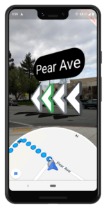
It’s been almost exactly a year since Google first promised us an augmented reality-aided navigation feature in its Maps product. The time to make good on that promise has arrived and the tech giant is delivering by rolling out AR-powered walking directions to Pixel smartphones in an ‘early preview’ mode.

In March, Google had made this functionality available to all Local Guides Level 5 and above for testing, and those users couldn’t stop raving about the resourcefulness of AR-guided navigation. Those early reviews had us all looking forward to the mass rollout of this exciting feature. But for now, it looks like only Pixel device users are going to enjoy next-gen walking directions. Google is yet to commit a date for when the feature will become available to all users.

How does Google Maps AR Navigation work?

In case you are wondering what the fuss is all about, AR navigation works on a concept which Google is calling global localization. With powerful machine learning algorithms running under the hood, the technique uses your mobile phone’s camera as a sensor to identify your position and orientation much more accurately than plain old GPS.

Instead of using GPS signals, Google Maps AR navigation feature determines the location of your phone by analyzing the key visual features, such as the outline of buildings or bridges, around you. It then searches for this imagery in Google Maps’ rich Street View repository and uses those reference points to apply triangulation.

Why your phone GPS may be inaccurate

The current GPS technology relies on measuring the delay of radio signals from multiple dedicated satellites to determine your precise location, and that is its biggest limitation.

“In dense urban environments like New York or San Francisco, it can be incredibly hard to pinpoint a geographic location due to low visibility to the sky and signals reflecting off of buildings. This can result in highly inaccurate placements on the map, meaning that your location could appear on the wrong side of the street, or even a few blocks away,” Tilman Reinhardt‎, Software Engineer, Google Maps, writes in a blog post.

Do you own a Pixel device? Do let us know your experience in comments. And if you do not, we highly recommend you borrow one from a friend or colleague to test out this awesome new Google Maps feature, just like they did:

Read on
Search