#Business #Ideas

iOS6 & Apple Maps. Two Main Reasons Why Is That Bad.

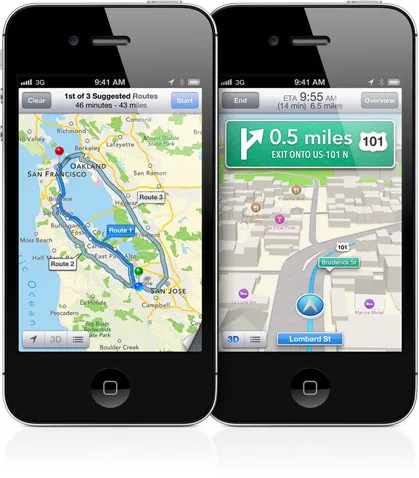
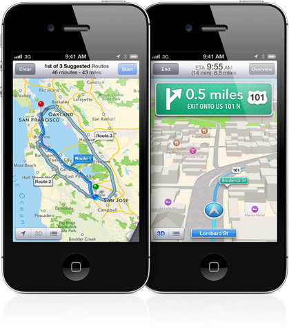
Back in May 2012 we’ve been discussing at Geoawesomeness what should Apple do with their $97.6bn cash reserves… very soon it appeared we were right… Apple Maps are out for several days already and they’re getting killed by users and critics. And rightly so! We’ll give you the main reasons why Apple Maps won’t be as good as Google Maps anytime soon:

1 .Geographic data is a key to success.

First and the most important thing – map has to be always based on geographic data and there are only few companies that can supply world-wide spatial data of acceptable quality: Google Maps through their API, Navteq (acquired  by Nokia in 2007 for $8,1 bln), TomTom and Open Street Maps. Trying to build their own mapping service Apple could not use Google’s or Nokia’s data, therefore they needed to licence it from what was left on the market: TomTom, OSM and other services like Yelp. Unfortunately (for Apple) Google and Nokia owns map data of the best quality. TomTom (which acquired TeleAtlas back in 2007 for €2.9 bln) is good but simply cannot be compared to Google, who’s Google Earth and Maps are based on decade of constant development and merging massive volume of data from . From the other hand the difference of Navteq (Nokia) and TeleAtlas (TomTom) is well reflected by the discepancy of their market capitalization back in 2007 and mainly related to better global coverage of Navteq data. So you can see that even comparing to Nokia, the quality of Apple Maps data is not really at the same level especially outside US and Western Europe and they cannot do anything about it.

2. You cannot build a mapping solution over the night.

As you recently read at Geoawesomeness the technology that stands behind Google Earth and Maps is something very sophisticated. Maps and Earth solutions has been acquired by Google in 2004. This means that it has been developed for several years already at that time. Over that time Google did something what they are really good at: something amazing;). They’ve actually changed the way people see maps, cartography, spatial information. They’ve actually built spatial awareness of people all around the world. Location context of many concepts, local search, places, location-based services, street view – it all started to be available and popular thanks to Google.

From the other hand Apple started to think about their map solution in 2009/2010. We’ve been following Apple mapping acquisitions sometime ago. It all started in mid 2009 when Cupertino quietly acquired Placebase – Maps API company. Than in 2010 – Poly9, a Canadian start-up that specialized in connecting mapping data with other data sources to create Google Earth-like visualizations. And finally in late 2011 they’ve bought C3 Technologies – Swedish Saab’s former military solution to automatically build 3D city models based on spatial areal imaginary captured from airplanes.

In theory these are components that are enough for a great map solution and it would be. In 2009. In 2012 Google has reached the level that is impossible to catch over the night.

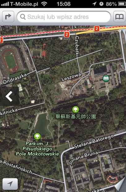
Park in the centre of Warsaw, Poland. Polish language has nothing to do with Chinese.


Say thanks for this article (0)
The community is supported by:
Become a sponsor
#Business
#Business
Geo Addressing Decoded Part 1: Why Does Geo Addressing Matter?
Aleks Buczkowski 04.16.2024
AWESOME 6
#Business #Contributing Writers #Fun #People
History of GIS | ESRI – A Pioneer in GIS Technology
Sebastian Walczak & Nikita Marwaha Kraetzig 07.26.2024
AWESOME 2
#Business #Featured
Global Top 100 Geospatial Companies 2025
GeoawesomeTeam 09.23.2024
AWESOME 5
Next article
#Business #Ideas

East African Geo Start-Ups Creating Awesome Location-Based Solutions

As the rate of mobile phone usage grows exponentially in Africa, some smart folks in East Africa are awesomely leveraging the situation to  empower themselves economically.

These folks are creating  wonderful and needful location-based service apps that run on mobile platforms and subscribers numeric strength growing swiftly.

NikoHapa (‘I am here)  is a Foursquare-like app created by some  Kenyan Start-ups. This app allows check in on Facebook and Twitter right on their mobile phones. Unlike Foursquare, NikoHapa works ultimately as a loyalty programme.

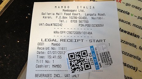
At  Mambo Italia  Galleria, NikoHappa users only need to send a text or scan a QR code found on the sticker on his or her receipt to check in and earn some loyalty points.


At Mambo Italia, users get a free 9-inch pizza after seven check-ins and each time a user wins a pizza it shows up in his or her facebook timeline. That’s free advertising, very clever!


At Blanco’s Sport Grill the first customer to use the service check-ins earns football shirts of local teams and food vouchers. Other customers choose from seven sporting fixtures.

The app creators make money from the subscription service. Increase in subscription rate means increase in money making for the creators.

Co-founder and chief executive Bernard Owuor says originally they were trying to build a way to send feedback to restaurants and shop owners via text message.

“We thought, why not put in a check-in system, so you can also tell your friends,” he says.

“Then we said, why not add an incentive. If you do it 10 times you get a discount. That’s how this developed.”

The feedback plus customer check-ins can provide useful analytics.

“It’s very hard to quantify the monetary value but loyalty programmes work.”

It is an engagement platform as well as a loyalty service and it is soon gonna spread to  other part of Africa said Bernard Owuor.


   Mutafa Go

Checking-in isn’t the only way that location technology is making life easier in east Africa

In the Ugandan capital Kampala, fuel shortages are an everyday occurrence.

This inspired a group of Makere University students to create an app called Mafuta Go, which shows you where the cheapest petrol is near you. It then tells you how to get there.

I am presently working on an app like this for ATM machines in the city of Abuja-Nigeria. The app is gonna help you discover the nearest ATMs within where you are and be able to tell you which ones are functional and dispensing cash. I got extremely pissed off one day after asking so many people for the locations of ATMs from where I was and ended up not getting money from any of those ATM locations.

Meka – Luganda

Meka – Luganda for “how much” – is Uganda’s first retail price comparison app and website created by a team of four smart Ugandan guys.

According to Mr Mugume, the app can help you find the cheapest shop you can get the particular stuff you want to buy. It is actually a good-shopping app.

“Let’s say you’re out shopping, you’re looking at this product – it’s about 500,000 [Ugandan shillings] – you can just pull out your phone, type it in, it will automatically do a search so you can see where you have the best deal.

“With the mobile apps it’s much cooler – it will actually give you the distance from where you are to the other stores that stock the item.” says Mugume.

They are also working on an app to automatically synchronise stock prices and availability for the bigger stores.

Great and awesome apps, these folks are developing, in Uganda smart phones are used to map the poorest and most far-flung areas and seamlessly synchronised to OpenStreetMaps.

In fact a another Silicon Valley is emerging in Nairobi Kenya where lots of great start-ups are making things work.

Well-done my fellow African smart geeks, lets keep at it and change the Single-Story perception of Africa.


Source : BBC News

Read on
Search