
 This reminds me of one of my Reference System’s classes in the Institute for Geoinformatics Muenster, Germany, when the professor asked to mention different ways to reference a location. And guys were mentioning: lat-long, place name, IP address, Wifi triangulation, RFID triangulation, Bluetooth and so on.
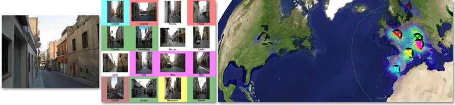
Wao!, If I knew, I could have stunned the class with this new referencing system called IM2GPS.
This is really a cool development; some smart researchers have come up with an algorithm to estimate the geographic coordinates of a photo/image using purely data-driven scene matching approach.
According to the research, we have over 6 million geo-tagged photos on the internet (for example on flickr), by running a computer image matching process on a photo over the 6 million geo-tagged photos on the net, the likelihood of getting a similar photo already geo-tagged on the internet is high. Hence the geographic coordinate of the photo in question can easily be abstracted from the geo-tagged match.
They also noted that the ”geolocation estimates can provide the basis for numerous other image understanding tasks such as population density estimation, land cover estimation or urban/rural classification” and that sounds interesting.
Interested in getting the details of the research get this Paper and enjoy! For more info, enjoy the GoogleTechTalk video below..


#Ideas


Next article

Do you think you know everything about GPS gadgets? You are wrong! Starcom systems – Israeli company has recently launched their latest product called WatchLock – the first padlock with GPS and GSM module… How does it work? The product is equipped with accelerometer – the one that allows you to play need for speed by moving your iPhone. When it detects the movement it launches the GPS and sends text message to predefined number.
I believe that it’s targeted mostly to the business clients however I can imagine to have my bike locked with this kind of gadgets gadget. I would have to be however very expensive bike because retail price of Watchlock will be probably much over $300 + monthly subscription for the web platform and GSM services.
One thing is sure: it’s definitely good quality – gsm and gps modules are provided by Swiss manufacturer u-blox.
Anyway, if the price does not scare you, you can still watch the video below.
source: Starcom Systems, U-blox

