

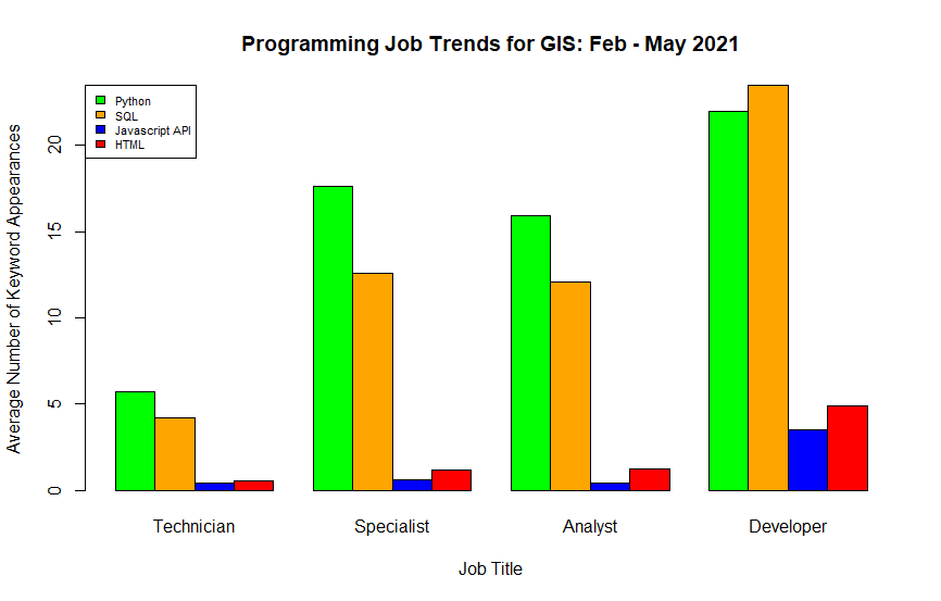
Illustration 1 – Programming Job Trends for GIS: Feb – May 2021
What skills do I need and for what roles?
GIS is a career field with a wide range of roles and applications. Entry-level GIS technician roles can involve plotting points on a map while advanced-level GIS developer roles can involve configuring the database structure for an organization completely from scratch. And what about GIS Analyst and GIS Specialist roles? What exactly do they entail? If you are new to the career field, or perhaps in the middle of it, what is needed to move forward? What skill sets are required and at what stage in your career do you need them? In an effort to answer this question for myself as I seek to take the next step in my geospatial journey from GIS Technician to GIS Analyst, I was inspired to write this program – which included teaching myself Python!
A Straight-Forward Approach
How does someone determine that information? One straight-forward approach is to pick a job site, search for the job title, read the job descriptions, and keep a count of the number of times a certain word appears. Rinse and repeat for all the words you are interested in. This would give you the information that you need, but it does come with a number of difficulties:
- Time commitment. Searching one job takes a few minutes. Searching a dozen jobs or more can take several hours.
- Human limitations. How many words can reasonably be kept track of during one scan? My guess would be in the 1-5 word range.
- Repetitive nature of the task. How long can someone really focus and be detailed-oriented when repeating the same mind-numbing exercise over and over?
An Automated Approach
What if there was a way to accomplish this task and address all of those difficulties at one time? Turns out, there is! One solution lies in using a combination of Python and R scripts to data mine job descriptions, keep a tally of key words, and visualize the results so that they can be easily interpreted. The process as presented in this article identified keywords from the first 25 search results using LinkedIn’s job search engine. The entire process follows this work flow model:
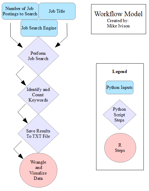
Illustration 2 – Job Trend Workflow Model
The Python script provides a output that looks something like this:
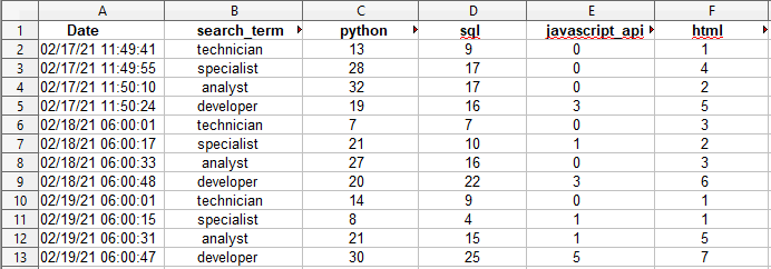
Illustration 3 – Sample Python Script Output
Once the information is in this format, it can be built into a data frame and queried to determine results. In this case, the R programming language was used to categorize the data by GIS Technician, Specialist, Analyst, and Developer. The mean number of search results for each keyword per category was calculated. This approach allows for a large number of skill set comparisons. The illustration at the top of this article compares programming job trends. A couple of other examples are trends comparing different Esri applications or Enterprise/Portal GIS solutions, as shown below:
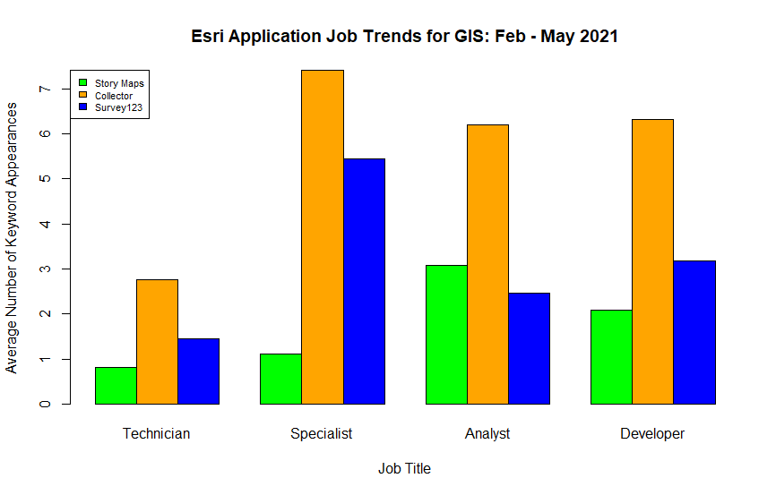
Illustration 4 – Esri Application Job Trends for GIS: Feb – May 2021
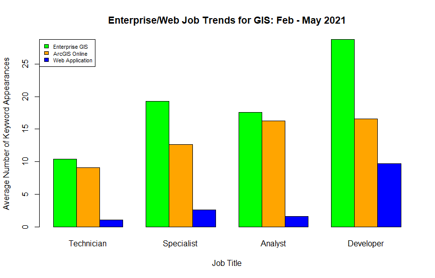
Illustration 5 – Enterprise/Web Job Trends for GIS: Feb – May 2021
As you can see, a lot of insight can be gained from the information when it has been gathered and visualized. Once the python script is written, it is adaptable and can be changed to search for new technologies or redefine keywords that may not be the ideal search term for the word. Changes in the visualization are also easy to accomplish because the R script imports an updated data set every time it runs.
Takeaways – and What’s Next?
As with any long-term GIS project, there will always be room for improvement. For instance, ArcMap and ArcPro were the keywords included in this data set. These are more conventionally written in job descriptions as ArcGIS Desktop and ArcGIS Pro, so the trends for those words were not reflective of reality and need to be adjusted in future iterations of the script. Or perhaps it might be better to compare ArcGIS Desktop vs. QGIS as ArcMap and ArcPro are sometimes included in job descriptions under the blanket term ArcGIS Desktop.
As this project is in early-stage development, it will be adjusted to reflect better results. However, there are some interesting trends that are already apparent. For instance, in the Programming Trends bar plot, programming skills are rather low for the GIS Technician role. Python and SQL become important in the GIS Analyst and GIS Specialist roles with Python slightly edging past SQL. In the GIS Developer roles, Javascript and HTML start to be required, and SQL takes a higher importance than Python. Additionally, the Esri Application bar plot identifies ArcGIS Collector as important in the Specialist, Analyst, and Developer roles while ArcGIS Survey123 seems more relevant in the Specialist role.
In conclusion, the geospatial career field is constantly evolving and tools like this will be a great way to keep track of the changes, adapt to them, and ultimately be successful. I hope this article was insightful. No matter where you are at in your geospatial career, I would encourage you to explore automated options, keep learning new things, and always strive to improve your GIS!


#GeoDev

Next article

Who knew that space technologies could give us a better understanding of how to protect our environment here on Earth?
Earth observation and space technologies have made it easier than ever to visualise and understand global challenges affecting nature. This allows us to build solutions that solve issues like vegetation changes and increasing air pollution.

Hackers in 10 cities across Europe will have an opportunity to build one of those solutions on 18-20 June at the first of six CASSINI Hackathons. This 3-day event will focus on digitising green spaces to benefit several outcomes related to daily life and resource conservation.
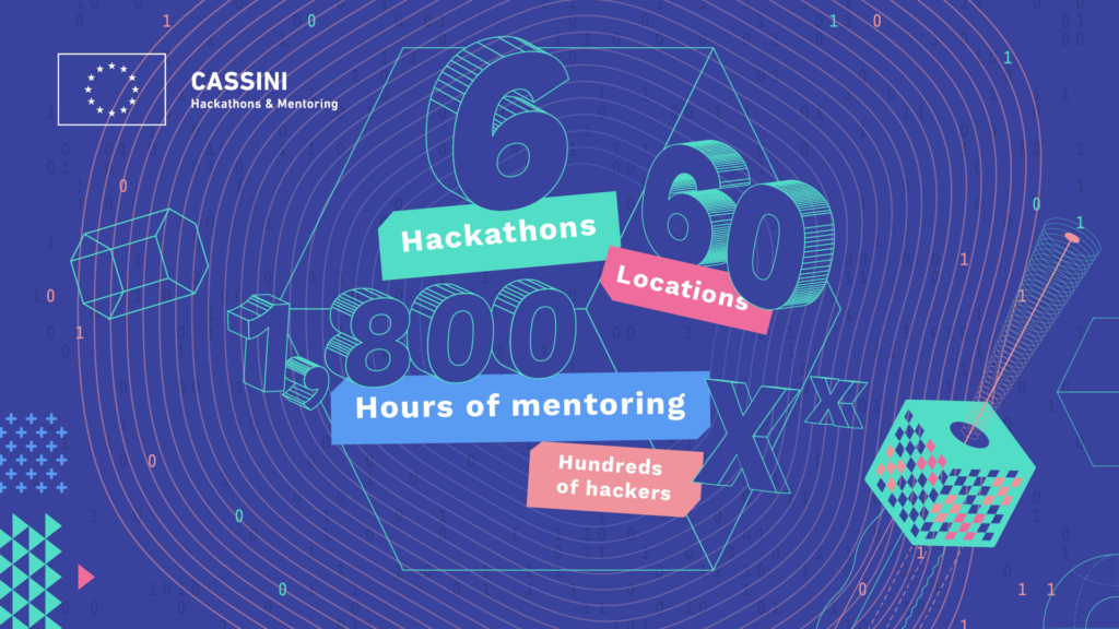
Created by the European Union, the CASSINI Hackathons and Mentoring events challenge participants to use Copernicus Earth Observation data and positioning technologies from Galileo and EGNOS to build their solution. They’ll also have access to technical and business experts for support during the event.
Hackers will compete in teams for prizes at the local and European level, and the 10 winners from each city will progress to a demo day and award ceremony. The top three teams will receive 100 hours of expert mentoring each to grow their projects into businesses.
Where and How to Compete
Local organisers will host all 10 events simultaneously in Cyprus, Czech Republic, Estonia, France, Greece, Ireland, Netherlands, Portugal, Slovenia and Switzerland. Participation requirements include living in an EU member state, Switzerland, Norway or Iceland.
To compete, hackers will join a team and select one of three challenges. The challenges require them to design products, devices or services with a specific goal:
- Discover your city: enable urban citizens to better understand their city and its green spaces. Focus on supporting urban planning, discovering green factors that contribute to residential area life or promoting ecological sustainability.
- Staying fit and healthy: support city dwellers in keeping their bodies and minds healthy. Focus on mapping and accessing green spaces for outdoor activity, forecasting air pollutants or understanding and monitoring UV exposure.
- Protecting our rural areas: promote the digitalisation of open and forested green spaces. Focus on conservation, ensuring healthy and resilient forests or developing new green spaces in underdeveloped areas.
Although tackling these challenges may sound complex, hackers don’t need any previous space technology experience to participate. The hackathon will also provide everything needed to compete, including virtual storage, computational resources and a code repository.
If hackers are still worried about competing with no earth observation or space technology experience, the organisers have that covered. There’s free training for the hackathon tools available online.
Don’t Miss Your Chance to Attend
The CASSINI Hackathons and Mentoring events are spreading awareness and accessibility of space technology to protect the world’s natural spaces. Don’t miss the chance to impact the health of our planet and grow a sustainable business in the process.
Hackers can register online for the event, and those interested in organising future hackathons can submit an application.
Keep up with the innovative projects underway during the hackathon by following #CASSINIHackathons on Twitter.

