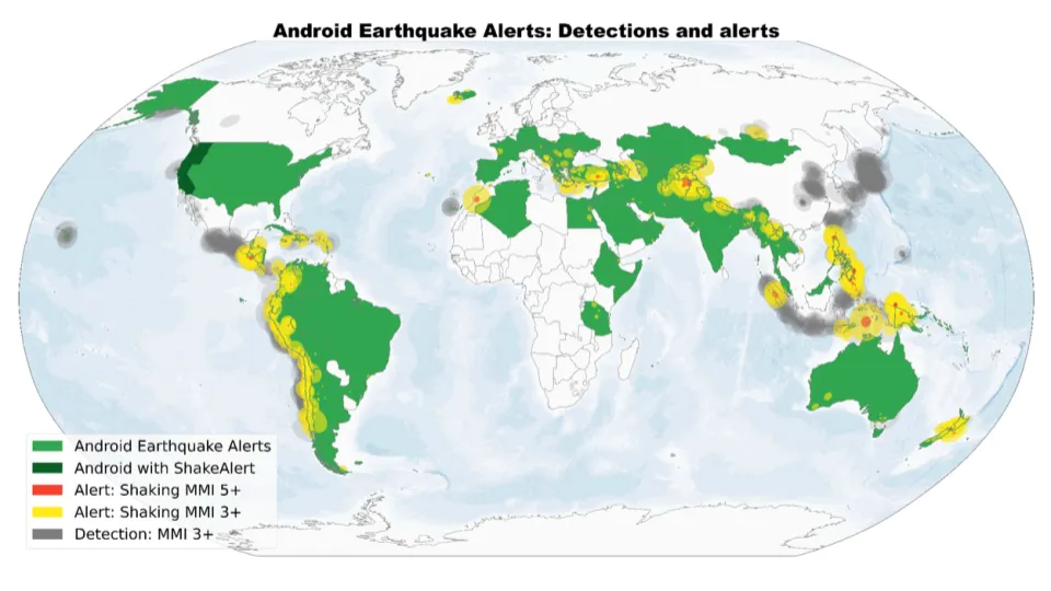

Google has developed a global earthquake detection system that uses Android smartphones to detect seismic activity and provide early warnings. Instead of relying on dedicated infrastructure, the system takes advantage of the accelerometers already built into billions of Android phones.
When an Android device is plugged in, stationary, and detects motion resembling a seismic P-wave, it sends an anonymized signal to Google’s servers. If many nearby phones detect the same pattern, the system identifies a likely earthquake, estimates its location and magnitude, and issues alerts to people in the area.
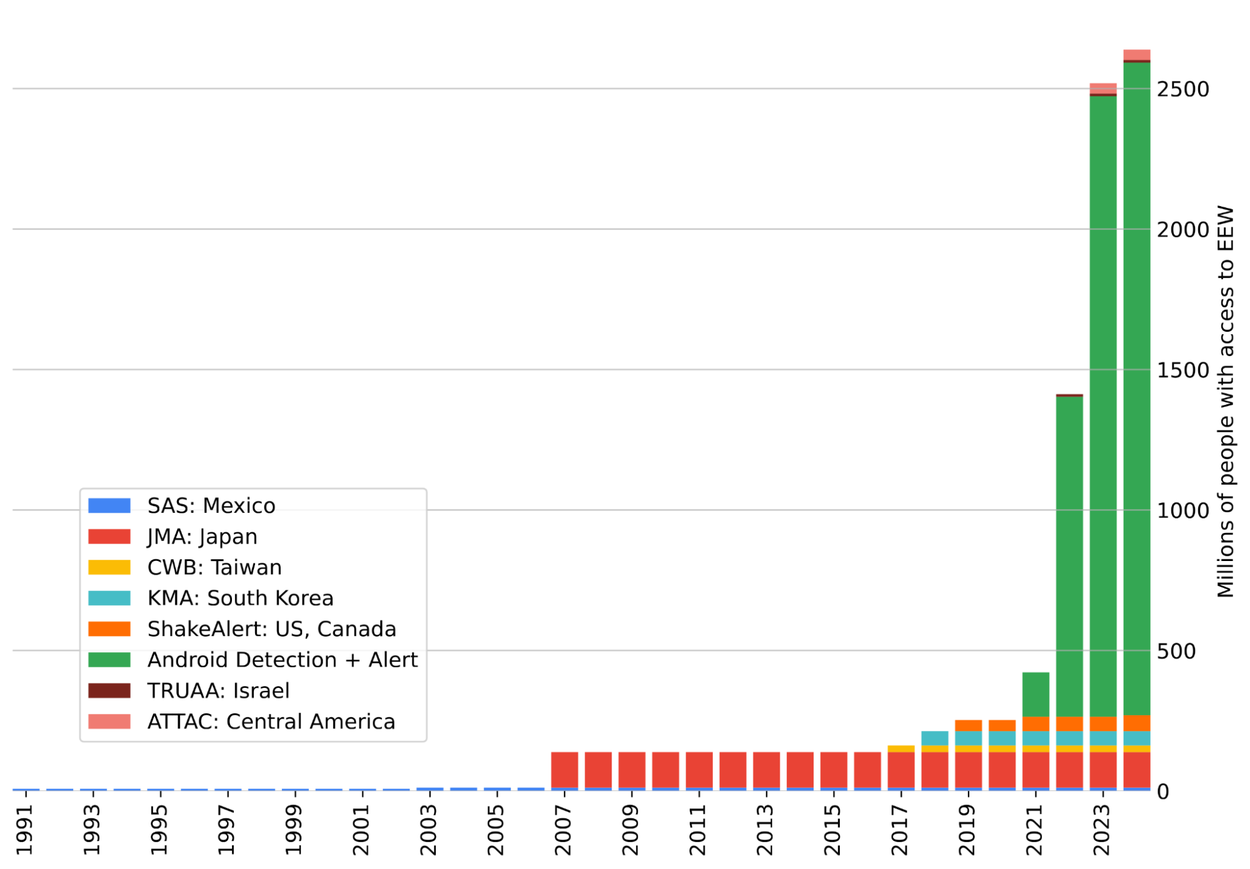
Between 2021 and 2024, this approach was used to detect over 11,000 earthquakes across nearly 100 countries. In many cases, users received alerts 15 to 60 seconds before the shaking started. These results, recently published in the journal Science, show that the system performs comparably to traditional seismic networks—particularly in regions where those networks don’t exist.
Google’s alert system has two levels: “Be Aware” for light shaking and “Take Action” for stronger shaking. These alerts are designed to be simple and fast, giving people a brief moment to react. In the U.S., the system works alongside ShakeAlert. In other countries without national alert systems—such as Indonesia, the Philippines, or Turkey—it provides a stand-alone warning service.
The system’s key advantage is scale. No additional hardware needs to be installed, and the reach of Android devices means even remote or under-resourced areas can benefit. However, there are limitations. Detection is less reliable in regions with low Android phone density, and the system still depends on user trust and timely data processing. Transparency about performance and partnerships with public safety agencies will be important for broader adoption.
This project shows how existing consumer technology can be repurposed to support public safety. While it doesn’t replace traditional seismology networks, it offers a useful additional layer—especially in places where alternatives don’t exist.
Google’s Android Earthquake Alerts System is a practical example of distributed sensing at global scale. With further development, it could significantly expand access to earthquake early warnings worldwide.
source: Google


#Ideas

Next article

Geo Sessions is back for a second year! With over 3,000 attendees from 120 countries at last year’s online event, NV5 is hosting Geo Sessions 2025 – a premier online thought leadership event happening September 16-18. This three-day event welcomes over 20 experts from public organizations, academia, and commercial industries to explore the latest trends, benefits, techniques, and applications of geospatial data and analysis. Airbus, USGS, e-GEOS, RIEGL Laser Measurement Systems, and British Geological Survey represent just a few of the organizations that will be speaking. See what the present and future of geospatial data looks like from their perspectives.
Each day features a dedicated 2-hour session focused on one of the three key data modalities:
- Lidar – September 16
- SAR (Synthetic Aperture Radar) – September 17
- Spectral – September 18
Hear what attendees said about last year’s Geo Sessions:
“Awesome presentations, thank you. Please continue with these Sessions. This is the first time I have watched and they have been incredibly interesting.”
– Attendee at UK Government, UK
“While some of the information covered in this series was over my head a bit, this was a great set of sessions. Thank you for sharing these experiences with us. I look forward to upcoming seminars.”
– Attendee at Civil & Environmental Consultants, Inc., USA
“The opportunity to hear from such experienced and diverse professionals in the field at no cost is incredibly valuable. Thank you all for this opportunity.”
– Attendee at FVA, Turkey
“Great idea to have these presentations. With climate change, the impact of transportation infrastructure, and difficulties in getting up-to-date data like aerial imagery (active or passive), I think satellite imagery can help manage the transportation assets’ life cycle.”
– Attendee at the Florida Department of Transportation, USA
Whether you’re already working with geospatial data or just beginning to explore its potential, Geo Sessions offers valuable insights into how lidar, SAR, and spectral data are shaping decision-making and innovation across industries.
The best part – this event is completely FREE to attend.
Check out the line-up of amazing speakers and reserve your spot today!
Not sure if you can attend? Register anyway to receive access to the recordings.
Questions or difficulties registering? Email geosessions@nv5.com.

