

Geographic Information Systems (GIS) and geospatial science have transformed how we understand and interact with our world. As part of our History of GIS series, we have put together a list of the top six figures in GIS and geospatial.
These individuals come from a diverse array of backgrounds and have made substantial contributions to the industry, highlighting the important roles played by all, including women and people of color, in advancing the field.
We consider it important to note that the contributions of many women of color in the early days of GIS and geospatial sciences may have been overlooked or underreported due to historical biases and lack of documentation.
The industry is continuously working towards better recognition and inclusion of diverse voices and contributions. We recognize this gap and want to provide a more comprehensive and inclusive account of the industry’s history, ensuring all significant contributions are properly acknowledged and celebrated.
Here’s a brief look at six of the most renowned personalities who have shaped these industries.
Dr. Gladys West is a pioneering mathematician whose work was crucial in developing the Global Positioning System (GPS). Born in 1930 in Virginia, she overcame racial and gender barriers to become one of the first Black women to work as a mathematician at the Naval Surface Warfare Center.
West’s groundbreaking contributions include creating precise mathematical models of the Earth’s shape, which were essential for GPS accuracy. She managed the Seasat project, the first satellite to monitor oceans, and worked on GEOSAT, improving our understanding of satellite geodesy.
Her work on accounting for gravitational and tidal forces on the Earth’s surface enabled precise satellite orbit calculations, forming the foundation of modern GPS technology. Dr. West’s achievements were belatedly recognized, including her 2018 induction into the Air Force Space and Missile Pioneers Hall of Fame.

Dr. Gladys West
- Jack Dangermond
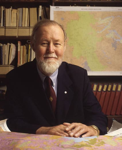
Jack Dangermond is the co-founder and president of Esri (Environmental Systems Research Institute), the world’s leading geographic information system (GIS) software company.
Born in 1945 in Redlands, California, Dangermond earned degrees in environmental science and urban planning before founding Esri with his wife Laura in 1969.
Dangermond’s contributions have been crucial in popularizing GIS technology and making it accessible to a broader audience. Esri’s ArcGIS software is one of the most widely used GIS platforms worldwide.
Under his leadership, Esri has become the global leader in GIS technology, serving over 350,000 organizations worldwide. His work has had a profound impact on various industries, from urban planning to environmental conservation. Dangermond is also known for his philanthropic efforts, particularly in environmental conservation and education.

Jack Dangermond. Source
Valerie Thomas is an American scientist and inventor best known for her work at NASA, where she developed image-processing systems for the Landsat program, the first satellite to capture real-time multispectral images of Earth.
Born in 1943 in Maryland, Thomas earned a degree in physics from Morgan State University and joined NASA in 1964. Her contributions to the Landsat program revolutionized Earth observation and resource management.
In 1980, she patented the illusion transmitter, a device that creates 3D optical illusions, which has applications in surgery and television.
Although now retired, Valerie Thomas, at 80 years old, continues to be a highly respected figure in her field and an inspiration to many. Her groundbreaking work and perseverance in the face of challenges serve as a powerful example for those pursuing careers in science and technology, especially for individuals from underrepresented groups.

Valerie Thomas. Source
- Roger Tomlinson
Often referred to as the “Father of GIS,” Roger Tomlinson is best known for his pioneering work in the development of GIS technology.
In the early 1960s, he created the Canada Geographic Information System (CGIS), the world’s first operational GIS, for the Canadian government’s Canada Land Inventory.
This groundbreaking work laid the foundation for modern GIS technology and its widespread application across various sectors. Tomlinson coined the term “geographic information system” and was instrumental in establishing GIS as a distinct field of study and practice.
Tomlinson’s contributions to the field have had a lasting impact on spatial analysis and data management practices. Throughout his career, Tomlinson continued to shape the GIS industry through his consulting work, academic contributions, and advocacy for geographic education.
Roger Tomlinson. Source
While not from the earliest days of GIS, Dr. Kwan has been a pioneer since the 1990s in using GIS for analyzing human activity patterns and transportation. Her work has been crucial in developing time-geographic methods in GIS.
Dr. Kwan received her Ph.D. in Geography from the University of California, Santa Barbara in 1994. She has held professorships at several prestigious institutions, including the University of Illinois at Urbana-Champaign and the Chinese University of Hong Kong.
Her groundbreaking work has focused on integrating time and space in GIS analysis, developing innovative methods for studying human mobility, environmental exposure, and health issues. Dr. Kwan’s research has been instrumental in advancing the field of time geography within GIS, providing new ways to analyze and visualize complex spatio-temporal data.
Dr. Kwan has received numerous awards for her contributions, including the American Association of Geographers (AAG) Stanley Brunn Award for Creativity in Geography and the AAG E. Willard and Ruby S. Miller Award.
Her work continues to influence a wide range of applications in urban planning, public health, and environmental studies.

Dr. Mei-Po Kwan
- Waldo Tobler
Waldo Tobler (1930-2018) was a renowned geographer and cartographer who made significant contributions to the field of Geographic Information Systems (GIS) and spatial analysis.
Known for formulating the First Law of Geography, “Everything is related to everything else, but near things are more related than distant things”, Tobler’s contributions to spatial analysis and computational geography have been foundational in GIS.
Tobler pioneered the use of computers in geographic research, focusing on mathematical modeling and graphic interpretations. He was a key figure in the development of digital cartography and spatial analysis techniques.
As a professor at the University of Michigan and later at the University of California, Santa Barbara, Tobler played a crucial role in advancing GIS technology and theory. His work earned him numerous honors, including membership in the National Academy of Sciences and the ESRI Lifetime Achievement in GIS Award.
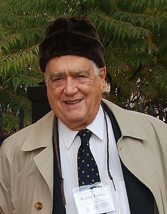
Waldo Tobler. Source
The Future of GIS: Inclusion and Innovation
The field of GIS and geospatial science has been shaped by the contributions of numerous influential figures. Their work continues to inspire and drive progress in the ways we analyze and interact with the world around us.
Inclusion and equity in GIS and geospatial science are not just moral imperatives; they are essential for innovation and progress. When we create environments where all voices are heard and valued, we unlock new potentials for solving complex spatial problems. The contributions of underrepresented groups have often led to novel applications of GIS technology, addressing issues that might otherwise have been overlooked.
As we look to the future of GIS and geospatial science, it’s clear that fostering diversity, ensuring inclusion, and promoting equity will be key to tackling global challenges.
By celebrating the contributions of pioneers from all backgrounds and actively working to make the field more accessible and inclusive, we can ensure that GIS and geospatial science continue to evolve and serve the needs of our diverse global community.
Did you like the article about top figures in GIS? Read more and subscribe to our monthly newsletter!


#Fun


Next article
Founding and History
Environmental Systems Research Institute (ESRI), now known as Esri, was founded in 1969 by Jack and Laura Dangermond.
Starting with a modest seed fund of $1,100, the company has grown into a major force in the geographic information system (GIS) software industry. Based in Redlands, California, Esri was established with a vision to help people understand and visualize geographic information to make informed decisions.
Initially, as a land-use consulting firm, Esri has now grown into the world’s leading supplier of GIS software, with a 40% market share and over a million active users across 350,000 organizations globally.
In the 1980s, Esri launched its first commercially available software product, ARC/INFO. This was a major innovation, as it transitioned GIS from a research and government domain into commercial markets. The 1990s saw Esri introducing ArcView GIS, which significantly expanded the user base by providing a more accessible, graphical GIS software option. By the 2000s, Esri had established ArcGIS as a comprehensive platform, moving GIS into the realm of web and server-based applications.
As the company’s flagship software, ArcGIS has become the industry standard, used by Fortune 500 companies, national governments, cities, and universities worldwide.
Recently, Esri has been integrating artificial intelligence and machine learning into its GIS products to enhance analytical capabilities and automate spatial data interpretation. This advancement allows for more sophisticated modeling and prediction in various applications.
Esri’s commitment to innovation has been crucial in advancing GIS technology. The company operates 11 research and development centers globally, constantly pushing the boundaries of what’s possible with spatial analysis and data visualization.
Key milestones in Esri’s history include:
1969: Esri is founded in Redlands, California.
1980s: Launch of ARC/INFO, Esri’s first commercially available software product.
1990s: Introduction of ArcView GIS, expanding the user base with a more accessible interface.
2000s: Development of ArcGIS as a comprehensive platform, bringing GIS to web and server-based applications.
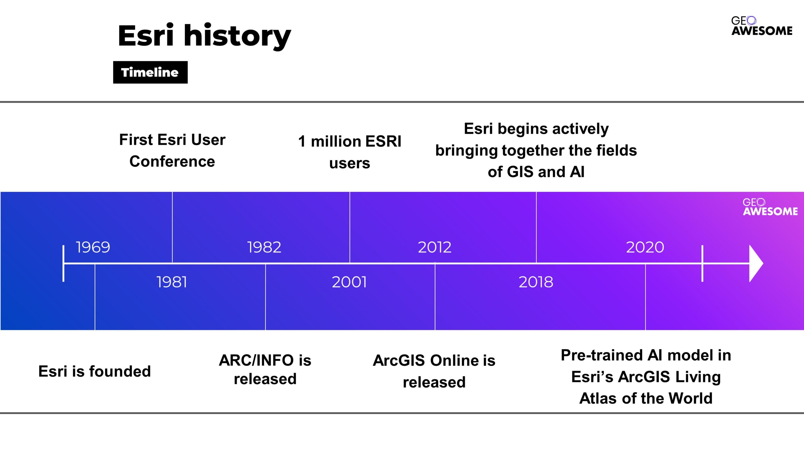
Esri history. Source: Esri
The Visionaries: Jack and Laura Dangermond
Jack and Laura Dangermond’s diverse backgrounds profoundly influenced their approach to founding Esri, shaping the company’s mission and trajectory.
Jack Dangermond, a landscape architect by training, has made significant contributions to the field of GIS. He studied at California State Polytechnic University, Pomona, and later earned advanced degrees from the University of Minnesota and Harvard University.
His vision for Esri was heavily influenced by his academic background and early career experiences, which highlighted the importance of geographic planning and environmental science. Under his leadership, Esri has remained a privately held company, emphasizing sustainable, long-term planning over short-term profits.
Laura Dangermond, a social scientist, contributed significantly to the operational and strategic aspects of Esri. Her interest in rational thinking and analysis complemented Jack’s technical expertise.
Together, they envisioned a technology that could balance human development with environmental stewardship. Laura’s role in managing the company’s operations was crucial in establishing Esri’s reputation and success in the GIS industry

Jack and Laura Dangermond. Source: Giving Pledge
Philanthropy and Recognition
Jack and Laura Dangermond are also noted philanthropists. In 2017, they donated $165 million to establish the Jack and Laura Dangermond Preserve on California’s central coast, the largest gift ever to The Nature Conservancy. They have also signed The Giving Pledge, committing to donate the majority of their wealth to charitable causes.
In recognition of their environmental efforts, the Dangermonds have received numerous awards, including the Conservation Visionary Award from the International Land Conservation Network and the United Nations Foundation’s Global 17 Innovation in Partnership Award.
Esri’s Product Ecosystem: Pioneering GIS Innovation
Esri’s flagship product, ArcGIS, offers a suite of software that integrates various aspects of geographic information. Their products are designed to meet diverse needs across industries and user types:
ArcGIS Pro
ArcGIS Pro is Esri’s powerful desktop GIS application, offering advanced capabilities for data visualization, analysis, and maintenance in 2D, 3D, and 4D environments. This feature-rich software serves as the cornerstone for professional GIS work, supporting complex spatial analysis and cartography.
ArcGIS Online
This cloud-based platform provides mapping, analysis, and data-sharing tools, enabling organizations to create, manage, and share geographic content across devices. ArcGIS Online facilitates collaboration and extends GIS capabilities beyond traditional desktop environments.
ArcGIS Enterprise
For organizations requiring on-premises or private cloud deployments, ArcGIS Enterprise offers a complete GIS platform that can be tailored to specific IT environments and security requirements.
Mobile Solutions
Esri has developed various mobile applications and SDKs, making GIS accessible for field data collection, real-time location analytics, and decision support on smartphones and tablets.
Developer Tools
Esri provides a comprehensive set of APIs and SDKs, allowing developers to integrate GIS capabilities into custom applications and extend the functionality of ArcGIS products.
Specialized Solutions
Esri offers industry-specific products and extensions, such as ArcGIS for Aviation, ArcGIS Urban, and ArcGIS Velocity, addressing unique geospatial challenges across various sectors
Esri’s technology supports various platforms including mobile devices, making GIS more accessible to field professionals and enhancing capabilities in data collection and real-time location analytics.
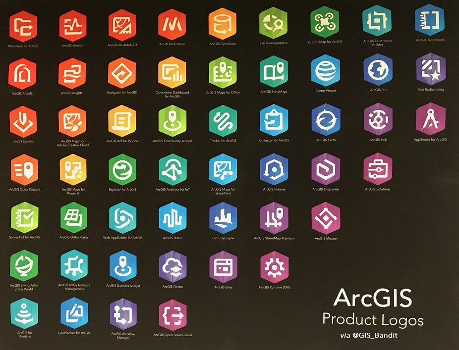
Esri products. Source: X
Community and Collaboration
Esri has cultivated a vibrant global community that serves as a cornerstone of its success.
The Esri Community demonstrates the company’s commitment to fostering collaboration and knowledge sharing among GIS professionals worldwide.
It serves as a platform where users can connect, share insights, and solve problems collectively. The community is an essential part of Esri’s user support and engagement strategy, reflecting Jack Dangermond’s belief in the power of collaborative innovation.
Esri Community Platform
The Esri Community platform is a hub where GIS professionals, developers, and enthusiasts converge to exchange ideas, troubleshoot challenges, and showcase innovative applications of Esri technology. Key features include:
- Forums for technical support and knowledge sharing
- User groups organized by geography, industry, or specific interests
- A robust ideas exchange where users can propose and vote on new features
- A resource center with tutorials, sample code, and best practices
This platform not only enhances user support but also drives product development by providing direct feedback to Esri’s teams.
Annual Esri User Conference
The Esri User Conference, held annually in San Diego, California, is the world’s largest GIS event. The most recent conference, held from July 15-19, 2024, attracted over 30,000 attendees from more than 140 countries. This event serves multiple purposes:
- Showcasing new Esri technologies and product updates
- Facilitating networking among GIS professionals
- Providing hands-on training and workshops
- Celebrating innovative applications of GIS through user presentations and the Map Gallery
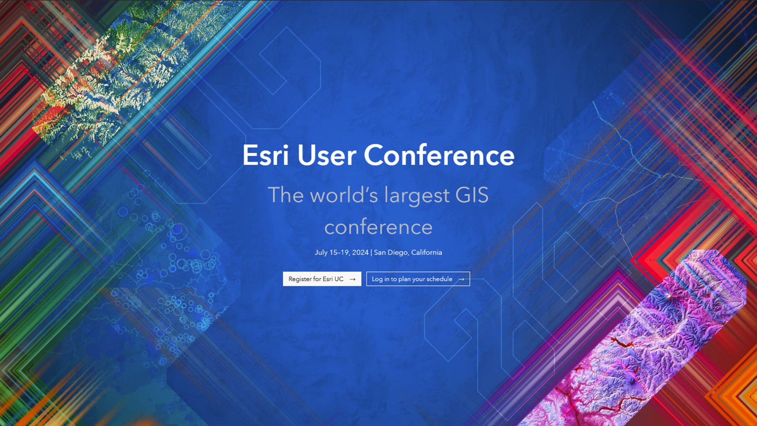
Esri User Conference
Esri’s Global Reach and Impact
Today, Esri stands as a leading entity in GIS technology, with a presence in over 100 countries and products translated into multiple languages. Their software is used by millions across various industries, including government, business, and academia, to make data-driven decisions related to geography and spatial planning. According to the EO Hub Report 2024, about 20% of surveyed participants are using Esri’s ArcGIS product.
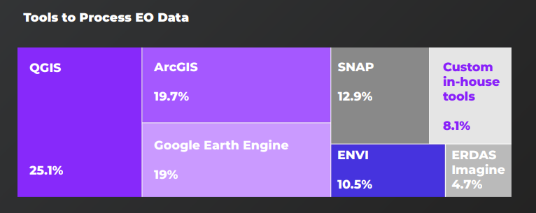
EO tools – the percentage of users
Esri’s Transformative Impact on GIS and Global Sustainability
Since its founding in 1969, Esri has revolutionized the field of geographic information systems (GIS) and significantly contributed to global sustainability efforts. Under the visionary leadership of Jack and Laura Dangermond, Esri has evolved from a small land-use consulting firm to the world’s leading GIS software company, profoundly influencing how organizations understand and interact with spatial data.
Jack and Laura Dangermond’s contributions have been widely recognized:
- In 2022, they received the Conservation Visionary Award from the International Land Conservation Network for their environmental efforts.
- In 2023, they were honored with the United Nations Foundation’s Global 17 Innovation in Partnership Award for developing mapping technology to address global issues.
Jack Dangermond was awarded the Planet and Humanity Medal by the International Geographical Union in 2021, a prestigious honor previously bestowed upon figures like Al Gore and Nelson Mandela.
The company’s sustained focus on community collaboration and technological advancement continues to shape how geographic information is used to address some of the world’s most challenging problems.
For more detailed information about Esri and its offerings, you can visit their official website and explore resources about the history and impact of GIS at the Esri blog.
Did you like the article? Read more and subscribe to our monthly newsletter!

