Founding and History
Environmental Systems Research Institute (ESRI), now known as Esri, was founded in 1969 by Jack and Laura Dangermond.
Starting with a modest seed fund of $1,100, the company has grown into a major force in the geographic information system (GIS) software industry. Based in Redlands, California, Esri was established with a vision to help people understand and visualize geographic information to make informed decisions.
Initially, as a land-use consulting firm, Esri has now grown into the world’s leading supplier of GIS software, with a 40% market share and over a million active users across 350,000 organizations globally.
In the 1980s, Esri launched its first commercially available software product, ARC/INFO. This was a major innovation, as it transitioned GIS from a research and government domain into commercial markets. The 1990s saw Esri introducing ArcView GIS, which significantly expanded the user base by providing a more accessible, graphical GIS software option. By the 2000s, Esri had established ArcGIS as a comprehensive platform, moving GIS into the realm of web and server-based applications.
As the company’s flagship software, ArcGIS has become the industry standard, used by Fortune 500 companies, national governments, cities, and universities worldwide.
Recently, Esri has been integrating artificial intelligence and machine learning into its GIS products to enhance analytical capabilities and automate spatial data interpretation. This advancement allows for more sophisticated modeling and prediction in various applications.
Esri’s commitment to innovation has been crucial in advancing GIS technology. The company operates 11 research and development centers globally, constantly pushing the boundaries of what’s possible with spatial analysis and data visualization.
Key milestones in Esri’s history include:
1969: Esri is founded in Redlands, California.
1980s: Launch of ARC/INFO, Esri’s first commercially available software product.
1990s: Introduction of ArcView GIS, expanding the user base with a more accessible interface.
2000s: Development of ArcGIS as a comprehensive platform, bringing GIS to web and server-based applications.
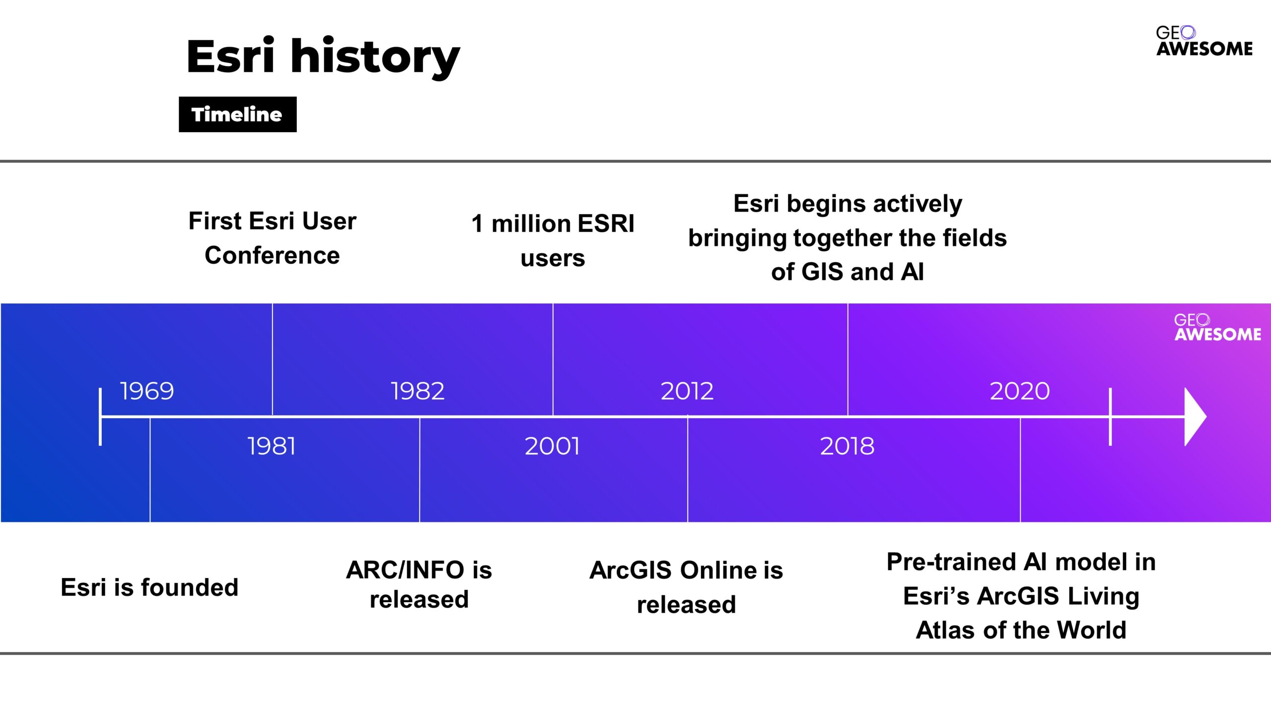
Esri history. Source: Esri
The Visionaries: Jack and Laura Dangermond
Jack and Laura Dangermond’s diverse backgrounds profoundly influenced their approach to founding Esri, shaping the company’s mission and trajectory.
Jack Dangermond, a landscape architect by training, has made significant contributions to the field of GIS. He studied at California State Polytechnic University, Pomona, and later earned advanced degrees from the University of Minnesota and Harvard University.
His vision for Esri was heavily influenced by his academic background and early career experiences, which highlighted the importance of geographic planning and environmental science. Under his leadership, Esri has remained a privately held company, emphasizing sustainable, long-term planning over short-term profits.
Laura Dangermond, a social scientist, contributed significantly to the operational and strategic aspects of Esri. Her interest in rational thinking and analysis complemented Jack’s technical expertise.
Together, they envisioned a technology that could balance human development with environmental stewardship. Laura’s role in managing the company’s operations was crucial in establishing Esri’s reputation and success in the GIS industry

Jack and Laura Dangermond. Source: Giving Pledge
Philanthropy and Recognition
Jack and Laura Dangermond are also noted philanthropists. In 2017, they donated $165 million to establish the Jack and Laura Dangermond Preserve on California’s central coast, the largest gift ever to The Nature Conservancy. They have also signed The Giving Pledge, committing to donate the majority of their wealth to charitable causes.
In recognition of their environmental efforts, the Dangermonds have received numerous awards, including the Conservation Visionary Award from the International Land Conservation Network and the United Nations Foundation’s Global 17 Innovation in Partnership Award.
Esri’s Product Ecosystem: Pioneering GIS Innovation
Esri’s flagship product, ArcGIS, offers a suite of software that integrates various aspects of geographic information. Their products are designed to meet diverse needs across industries and user types:
ArcGIS Pro
ArcGIS Pro is Esri’s powerful desktop GIS application, offering advanced capabilities for data visualization, analysis, and maintenance in 2D, 3D, and 4D environments. This feature-rich software serves as the cornerstone for professional GIS work, supporting complex spatial analysis and cartography.
ArcGIS Online
This cloud-based platform provides mapping, analysis, and data-sharing tools, enabling organizations to create, manage, and share geographic content across devices. ArcGIS Online facilitates collaboration and extends GIS capabilities beyond traditional desktop environments.
ArcGIS Enterprise
For organizations requiring on-premises or private cloud deployments, ArcGIS Enterprise offers a complete GIS platform that can be tailored to specific IT environments and security requirements.
Mobile Solutions
Esri has developed various mobile applications and SDKs, making GIS accessible for field data collection, real-time location analytics, and decision support on smartphones and tablets.
Developer Tools
Esri provides a comprehensive set of APIs and SDKs, allowing developers to integrate GIS capabilities into custom applications and extend the functionality of ArcGIS products.
Specialized Solutions
Esri offers industry-specific products and extensions, such as ArcGIS for Aviation, ArcGIS Urban, and ArcGIS Velocity, addressing unique geospatial challenges across various sectors
Esri’s technology supports various platforms including mobile devices, making GIS more accessible to field professionals and enhancing capabilities in data collection and real-time location analytics.
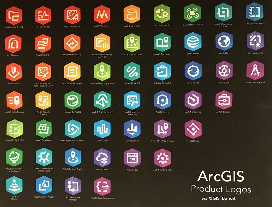
Esri products. Source: X
Community and Collaboration
Esri has cultivated a vibrant global community that serves as a cornerstone of its success.
The Esri Community demonstrates the company’s commitment to fostering collaboration and knowledge sharing among GIS professionals worldwide.
It serves as a platform where users can connect, share insights, and solve problems collectively. The community is an essential part of Esri’s user support and engagement strategy, reflecting Jack Dangermond’s belief in the power of collaborative innovation.
Esri Community Platform
The Esri Community platform is a hub where GIS professionals, developers, and enthusiasts converge to exchange ideas, troubleshoot challenges, and showcase innovative applications of Esri technology. Key features include:
- Forums for technical support and knowledge sharing
- User groups organized by geography, industry, or specific interests
- A robust ideas exchange where users can propose and vote on new features
- A resource center with tutorials, sample code, and best practices
This platform not only enhances user support but also drives product development by providing direct feedback to Esri’s teams.
Annual Esri User Conference
The Esri User Conference, held annually in San Diego, California, is the world’s largest GIS event. The most recent conference, held from July 15-19, 2024, attracted over 30,000 attendees from more than 140 countries. This event serves multiple purposes:
- Showcasing new Esri technologies and product updates
- Facilitating networking among GIS professionals
- Providing hands-on training and workshops
- Celebrating innovative applications of GIS through user presentations and the Map Gallery

Esri User Conference
Esri’s Global Reach and Impact
Today, Esri stands as a leading entity in GIS technology, with a presence in over 100 countries and products translated into multiple languages. Their software is used by millions across various industries, including government, business, and academia, to make data-driven decisions related to geography and spatial planning. According to the EO Hub Report 2024, about 20% of surveyed participants are using Esri’s ArcGIS product.
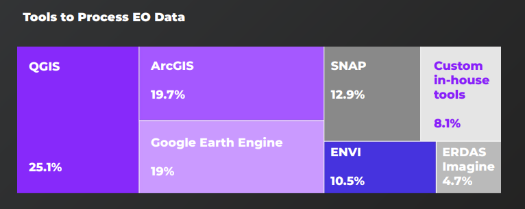
EO tools – the percentage of users
Esri’s Transformative Impact on GIS and Global Sustainability
Since its founding in 1969, Esri has revolutionized the field of geographic information systems (GIS) and significantly contributed to global sustainability efforts. Under the visionary leadership of Jack and Laura Dangermond, Esri has evolved from a small land-use consulting firm to the world’s leading GIS software company, profoundly influencing how organizations understand and interact with spatial data.
Jack and Laura Dangermond’s contributions have been widely recognized:
- In 2022, they received the Conservation Visionary Award from the International Land Conservation Network for their environmental efforts.
- In 2023, they were honored with the United Nations Foundation’s Global 17 Innovation in Partnership Award for developing mapping technology to address global issues.
Jack Dangermond was awarded the Planet and Humanity Medal by the International Geographical Union in 2021, a prestigious honor previously bestowed upon figures like Al Gore and Nelson Mandela.
The company’s sustained focus on community collaboration and technological advancement continues to shape how geographic information is used to address some of the world’s most challenging problems.
For more detailed information about Esri and its offerings, you can visit their official website and explore resources about the history and impact of GIS at the Esri blog.
Did you like the article? Read more and subscribe to our monthly newsletter!


#Contributing Writers


Next article
From Digital Footprints to Urban Intelligence: Leveraging Public GPS Traces
In our increasingly connected world, public GPS traces are a powerful tool for understanding human movement and geographical interactions. These digital footprints offer a window into the patterns of mobility that shape our world.
What are Public GPS Traces?
Public GPS traces are anonymized datasets that consist of geographical coordinates collected from devices equipped with GPS technology. These traces represent the movement of individuals or objects over time, providing insights into:
- Urban mobility patterns
- Traffic flow dynamics
- Geographic usage trends
- Popular routes and destinations
The beauty of public GPS traces lies in their collaborative nature.
Many services encourage users to share their GPS data, creating a vast, crowd-sourced repository of movement information that fuels analytical projects and enhances our understanding of human geography.
Harnessing the Power of Collective Data
Examples of Services Using Public GPS Traces
Several platforms have recognized the potential of public GPS and integrated them into their services:
OpenStreetMap (OSM)
OSM is a free, editable map of the world that is a collaborative project and testiment to the power of collaborative mapping. Using OSM, you’re able to:
- Verify existing map information
- Identify and add missing paths of roads
- Enhance the accuracy and detail of global cartography
By allowing users to upload their GPS traces, OSM continually refines its maps, ensuring they reflect the most up-to-date geographical realities.
These traces are crucial for the accuracy and expansion of OSM’s detailed global map.
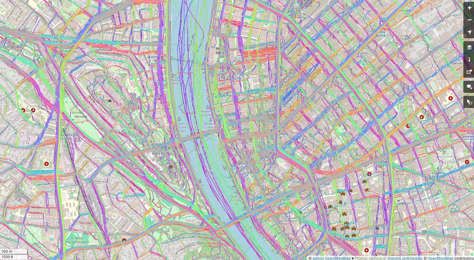
Public GPS traces in Budapest. Source: OpenStreetMap
Strava
Strava, a popular fitness tracking platform, is popular among athletes, particularly runners and cyclists. Through its Strava Metro program, the company aggregates and anonymizes GPS traces from millions of activities to:
- Identify popular cycling and running routes
- Assist in urban infrastructure planning
- Provide insights for public health initiatives
Strava also uses aggregated public GPS data to generate heatmaps showing popular routes, aiding new users in finding recommended paths for their activities.
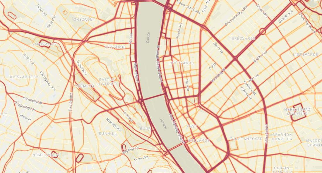
Public GPS traces in Budapest. Source: Strava
These examples illustrate how public GPS traces, when harnessed effectively, can bridge the gap between individual movements and collective urban intelligence, paving the way for smarter, more responsive cities.
Case Study: Detecting Population Density in Cities
A fascinating application of public GPS traces is studying urban population density and movement, particularly in cities like Budapest, Kraków, and Berlin. This case study involves several steps, utilizing GPS data to generate insights into how locals and tourists frequent areas of these cities.
Data Collection
The initial step involved downloading GPS points’ locations from Budapest, Kraków, and Berlin using the API provided by OpenStreetMap. This API allows for the extraction of GPS traces within specified geographical boundaries, making it possible to gather comprehensive data on movements within these cities. The most recent 500,000 points were downloaded to perform trends in visiting places in the mentioned cities. This data, representing both locals and tourists, offered a unique opportunity to analyze real-time urban dynamics.
Data Analysis and Visualization
Using GIS software, the collected data points were first visualized directly. This initial visualization aimed to identify which streets and areas had the highest rates of visitors. However, directly plotting the points on a map proved to be ineffective; the sheer volume of data points made the tool slow and the resulting visuals cluttered and difficult to interpret.
To resolve this, a more refined approach was taken using a Heatmap (Kernel Density Estimation) tool within the GIS software. This method processes the geographical data points to produce a smooth gradient heatmap, indicating areas of high concentration without the clutter of individual data points. This visualization was not only faster but also provided a clearer, more useful representation of traffic and population density.
Key Findings and Implications
The heatmaps revealed several insights:
- High-Traffic Hotspots: Our analysis identified major hotspots, key areas in each city with consistently high foot traffic
- Tourist vs Local Patterns: By comparing data patterns, we can distinguish between areas frequented by tourists and those popular among locals
- Temporal Variations: Through heatmaps, we can see how population density fluctuates throughout the day and week, offering insights into urban rhythms
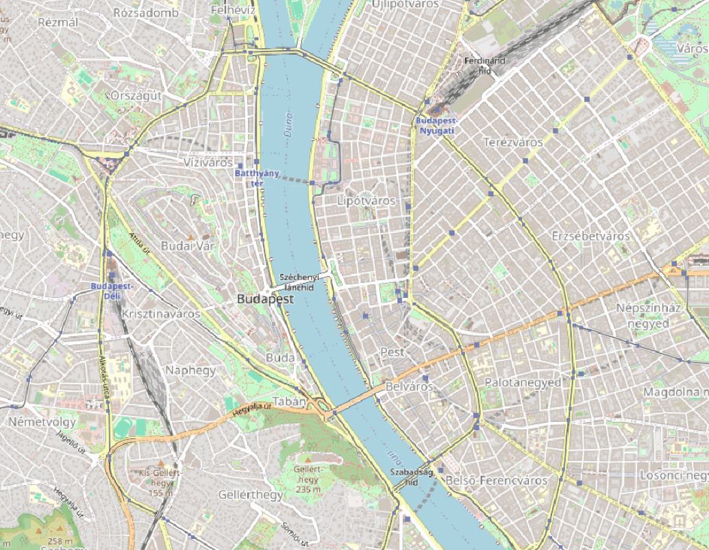
Case study – Budapest: OSM visualization, GPS points, Heatmap (based on points), Heatmap (Kernel Density Estimation algorithm)
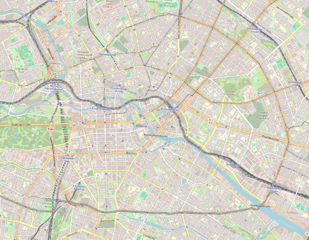
Case study – Berlin: OSM visualization, GPS points, Heatmap (based on points), Heatmap (Kernel Density Estimation algorithm)
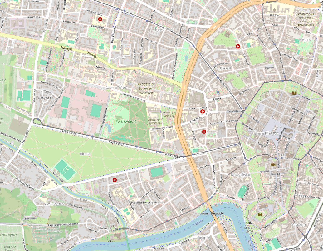
Case study – Kraków: OSM visualization, GPS points, Heatmap (based on points), Heatmap (Kernel Density Estimation algorithm)
Applications of Heatmaps in Various Fields
Heatmaps generated from public GPS traces find utility across multiple domains:
- Urban Planning: Planners use heatmaps to identify heavily trafficked areas that might benefit from infrastructural improvements such as wider sidewalks, more crosswalks, or enhanced public transportation services.
- Retail Strategy: Retailers can analyze heatmaps to choose store locations based on areas with high pedestrian traffic, optimizing footfall and potential sales.
- Event Management: During large events, heatmaps of attendee movements can help in managing crowds more efficiently and in designing better layouts for future events
- Environmental Impact Studies: Environmental researchers use GPS data to understand the impact of human activity on natural reserves and parks, helping to manage and protect these areas.
- Transportation Engineering: Traffic patterns derived from GPS data help in designing better road networks, potentially reducing congestion and enhancing safety.
The Power of Public GPS Traces
Public GPS traces offer a treasure trove of data that can be leveraged in plenty of ways. From improving city layouts through informed urban planning to aiding businesses in making better location-based decisions, the applications are vast.
This vast repository of geospatial data is revolutionizing our approach to urban studies, business strategies, and public services.
As GPS technology becomes even more pervasive and the quality of data improves, the future possibilities for utilizing public GPS traces in professional and academic studies will undoubtedly expand. The potential of public GPS traces in shaping our understanding of urban dynamics is immense.
As we harness the power of public GPS traces, it’s crucial to address privacy concerns and ensure the ethical use of data. Striking a balance between data utilization and individual privacy will be key to the sustainable and responsible use of this technology.
Did you like the article? Read more and subscribe to our monthly newsletter!

