#Business #GeoDev #Ideas

Google’s latest game turns scribbles into satellite imagery


Land Lines” from Google is a really addictive game that converts your random scribble into an actual geometric pattern that is visible from space. And its right in time for the holidays.

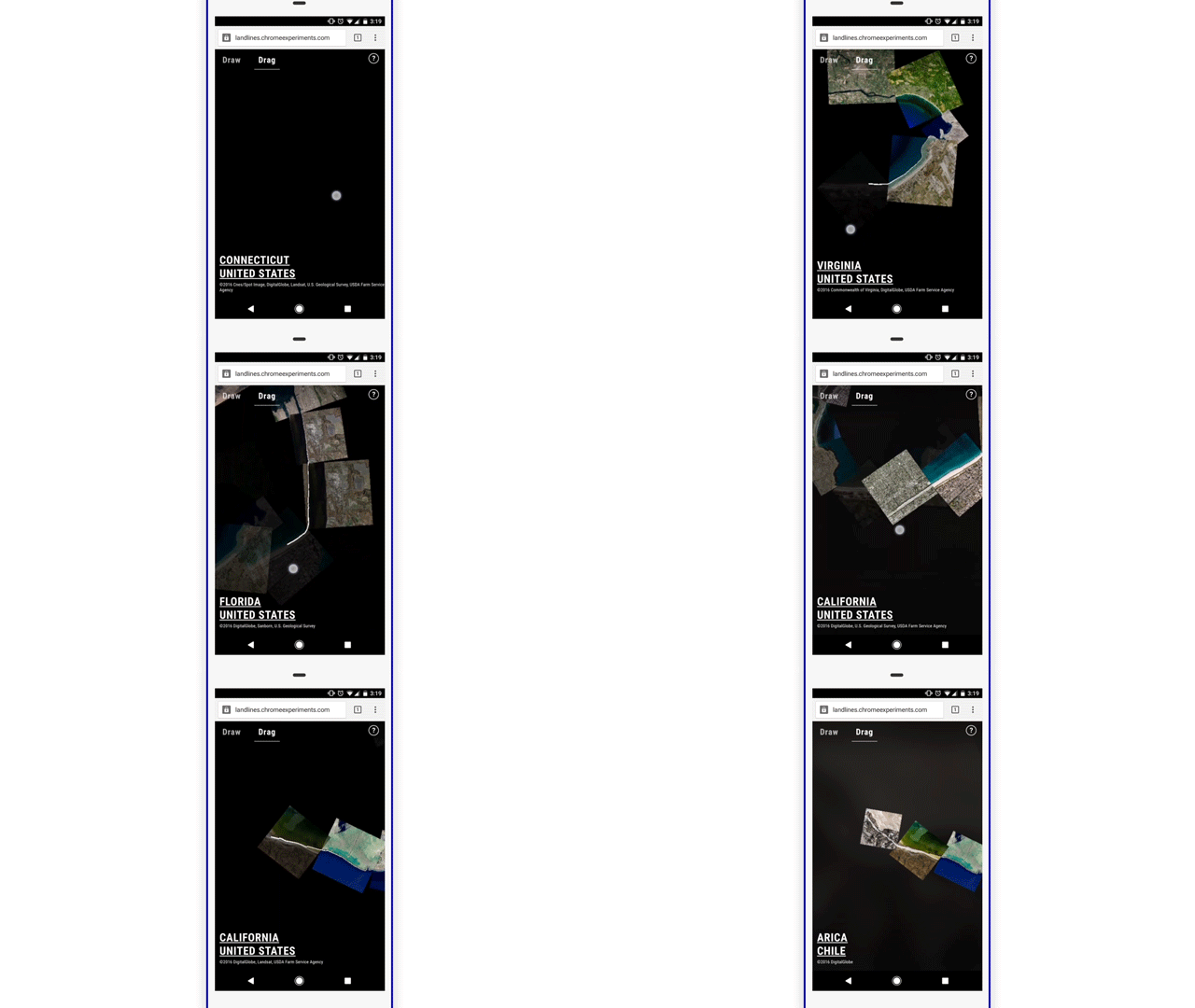
All you got to do is to drag or draw across the screen and “Land Lines” will complete the picture for you – finding a water body, highway, river, landmass; something that matches the pattern of your scribble.

“Start with a line, let the planet complete the picture”  –  Zach Lieberman

By Zach Lieberman – Land Line Project

Land Lines is a Chrome experiment made by two creative coders Zach Lieberman and Matt Felsen in collaboration with the Google Data Arts Team. The game works on your phone (or PC’s) web browser without the need for a dedicated app (or backend servers).

Draw or Drag

It’s amazing to witness your random scribble turn into a full picture of the earth and what’s even more mesmerizing is that the same pattern throws up a different satellite imagery each time.

If drawing random scribbles isn’t entertaining enough, you can also drag across the screen and travel across the globe in a seamless connected fashion. The “drag” mode is way more engrossing than the “draw” mode!

By Zach Lieberman – Land Lines Project

If you are interested in learning more about the project, check out the source code on GitHub or read the technical case study.


Say thanks for this article (0)
The community is supported by:
Become a sponsor
#Business
#Business #Featured #GeoDev
Geo Addressing Decoded, Part 4: Exploring the Applications of Geo Addressing Solutions
Aleks Buczkowski 06.25.2024
AWESOME 2
#Business
Geo Addressing Decoded Part 1: Why Does Geo Addressing Matter?
Aleks Buczkowski 04.16.2024
AWESOME 6
#Business #Featured #Ideas
Why Have Scientific Datasets Been So Widely Adopted in Earth Observation and What Role Does Data Quality Play?
GeoawesomeTeam 07.17.2024
AWESOME 4
Next article
#Environment

Why do we have seasons on Earth?

Yesterday we experienced a shortest day of the year in the northern hemisphere. The December solstice happens every year around December, 21st. This made me want to think about why do we seasons on Earth? In theory we all know it but in practice you might want to refresh you basic geographic knowledge…

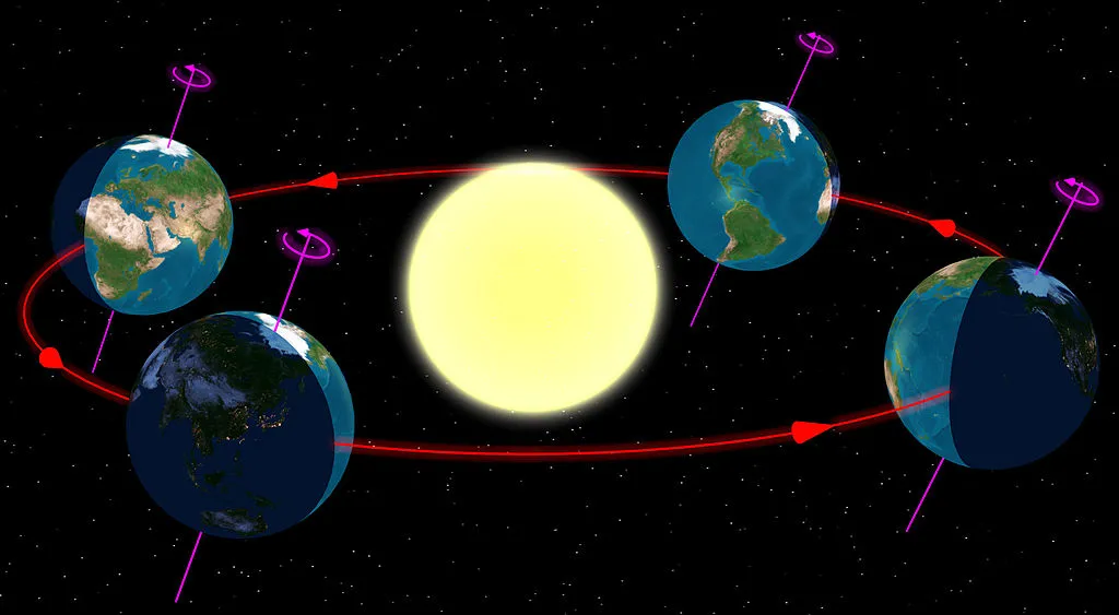
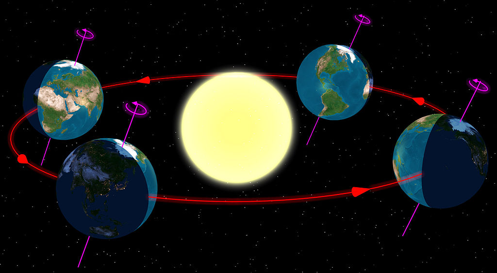
We experience seasons because our planet rotates on an axis that is tilted by 23.5 degrees in its orbit. The Earth orbits around the sun every 365.256 days. This tilt makes northern hemisphere to be closer and more exposed to the sun for half of the time and southern hemisphere for another half.

What is the key to understand this phenomena is that over the course of a year, the angle does not change so Earth’s axis is always pointing the same direction in space. But as we orbit the sun the orientation of Earth’s tilt with respect to the sun changes.

Some may argue that the seasons are also influenced by the fact that Earth distance from the sun does change throughout the year. But in the case of our planet the change is too small to cause it.

If the idea is still a bit blurry you might want to watch this video:

With that we send greetings to all the Flat Earthers on your round planet.

Read on
Search