#Business #Featured #Ideas

Geospatial Industry you are a Mess!

Geospatial industry look at yourself in the mirror. Be honest. What do you see?

Are you well groomed, carefully put together? Do you clearly express who and what you are?

Let me tell you what I think. You’re a mess. There I have said it.

Geospatial Industry you are a Mess!

Why, you might ask, am I being so rude; accusing the geospatial industry of being a mess? Because of a recent conversation that is why!

Let me share the story. We were approached by an organization towards the end of 2016 who had built their own in-house GIS. Intended for desktop use only, the application provided a nice set of tools. But the organization was coming under pressure from some of its clients for all device access to these tools. That means PC, laptop, smartphone and tablet. In short they needed to rebuild their solution. “We would like a Google solution if possible”, was what they stated in our first call together. We gently explained that Google would likely not be able to provide what they required. They needed an enterprise geospatial solution. They scurried off to do some research. Enterprise geospatial solution indeed.

Two weeks later they called us again. This time quite frustrated. They had trawled the web, even had direct conversations with geospatial vendors, and they were close to pulling their hair out:

“How are they different .. Esri, MapBox, Carto, Autodesk, Pitney Bowes, Boundless, Azimap? What a hideously confusing landscape, we are more confused now than ever.”

Their confusion (and frustration) is shared by many. More ‘where’ questions are now being asked. Organizations new to enterprise geospatial solutions are becoming interested. As an industry we are doing a wonderful job of confusing these potential new customers.

These are some of the questions being asked, can you provide a clear, simple answer?

  • Who are you? What do you offer? How are you different? Who do you serve?
  • I read you are competitive. I read you complement one another. Which is it to be?
  • I have a ‘where’ problem in need of a solution. I care little about the technology. How do I find out who is best placed to answer my question, and not bore me with a ‘promise everything’ sales pitch?
  • If you truly offer the best solution for my unique problem; where do I start? How do I move forward? Will you guide me?

So which solution did this organization finally choose? I’ll leave that for you to guess.

Say thanks for this article (0)
The community is supported by:
Become a sponsor
#Business
#Business #Fun #Ideas #People
History of GIS | Top 6 Figures in GIS and Geospatial
Nikita Marwaha Kraetzig 08.12.2024
AWESOME 3
#Business #Featured #GeoDev
Geo Addressing Decoded, Part 3: Diving into the Key Features of Precisely’s Geo Addressing System
Aleks Buczkowski 06.29.2024
AWESOME 4
#Business #Featured #GeoDev
Geo Addressing Decoded Part 2: Beyond Coordinates – Exploring the Depth and Impact of Geo Addressing
Aleks Buczkowski 05.2.2024
AWESOME 4
Next article
#Business #Ideas

2017 in Geo according to Javier de la Torre, CEO at CARTO

The geospatial industry overall will continue growing strong in 2017. Some big trends like IoT, Self-driving Cars, Location based Consumer apps and space will keep pushing the industry to new areas.

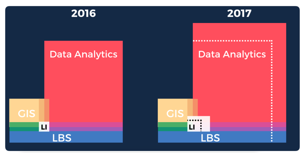
The separation between different areas in the geospatial industry will become more apparent. GIS will remain niche, but I expect strong growth in the Data Analytics space and Location Based Services (LBS). The usage of geospatial technology will increase very significantly within enterprises as they continue to become more data-driven; this will help solidify the Location Intelligence segment. The next 1 Million users to start using geospatial technology in 2017 will not even know what GIS is. Location Intelligence will be delivered seamlessly via their apps, embedded in Data Analytics space, as a new software segment, or integrated on general purpose tools and platforms. This is the segment where CARTO will be focused the most.

In terms of specific trends within the geospatial community, I believe the following things will happen or continue happening on 2017.

  • Commoditization of Location Based Services with value-added services on top of traditional LBS.
  • OSM and Open Data will keep getting space and will become the inevitable 3rd option after Google Maps and Apple Maps.
  • GIS will capitalize on IoT trends, but will be replaced often with software capabilities on other products.
  • More and more products will include geospatial technologies taking it mainstream. Concepts of Spatial Analysis will be more natural to a much larger audience.
  • Predictive analytics on Spatial Data will start becoming much more common and Machine Learning techniques will be much more clearly applied to Location Data.
  • Some core companies will continue absorbing incredible geospatial talent (Uber, Google, Facebook…) and startups (like CARTO!) will specialize in certain type of analysis and data.
  • We will likely continue talking about counting cars in Walmart parking lots from space.
  • There will be more technology sector consolidation in 2017 than in 2016 as different platforms keep adding spatial capabilities and big companies augment their pool of talent.
Read on
Search