#Business #Ideas

GeoGuessr – Street View-Based Geography Game

GeoGuessr - overview

GeoGuessr is a popular online geography game that was created by Anton Wallén, a Swedish IT consultant and developer. It was launched in May 2013 and quickly gained widespread attention due to its unique concept and addictive gameplay.

Here are some hightlights about this app:

  1. Concept: The game utilizes Google Maps Street View imagery to randomly place players in locations around the world. Players have to guess their location based on the surroundings they see in Street View.
  2. Game Modes: Initially, GeoGuessr featured a single game mode where players were placed in a random location. However, over time, the game introduced various modes including “Challenge” mode where players compete against each other, and “Battle Royale” mode where multiple players compete to guess locations in a shrinking map.
  3. Popularity: GeoGuessr became immensely popular shortly after its release, attracting players from all over the world. It gained attention not only among casual gamers but also among educators who found it to be a valuable tool for teaching geography.
  4. Educational Tool: Many teachers and geography enthusiasts use GeoGuessr as an educational tool to teach geography and improve geographic knowledge. Its immersive gameplay encourages players to explore different regions, landmarks, and cultures around the world.
  5. Community: GeoGuessr has a strong online community with dedicated forums, social media groups, and competitions. Players often share their memorable experiences, challenging locations, and impressive guesses with fellow enthusiasts.
  6. Development: Over the years, GeoGuessr has undergone several updates and improvements, including the addition of new features, maps, and game modes. The game continues to evolve to keep players engaged and entertained.
  7. Challenges: While some locations in GeoGuessr are relatively easy to identify based on landmarks or language clues, others can be extremely challenging, especially in remote or less populated areas. This adds to the excitement and replay value of the game.
  8. Global Appeal: One of the remarkable aspects of GeoGuessr is its ability to appeal to players of all ages and backgrounds from around the world. Whether you’re a geography buff, a casual gamer, or someone looking for a fun way to explore the world, GeoGuessr offers something for everyone.

Overall, GeoGuessr has proven to be not only a fun and entertaining game but also a valuable educational tool and a platform for fostering global curiosity and exploration.

Also see: Google Earth’s Carmen Sandiego game will give ’90s kids serious déjà vu


Did you like the article about GeoGuessr? Read more and subscribe to our monthly newsletter!

Say thanks for this article (50)
The community is supported by:
Become a sponsor
#Business
#Business #Featured
The Earth Observation Hub Report: 2024 Industry Trends and Analysis
Avatar for Muthukumar Kumar
Muthukumar Kumar 03.13.2024
AWESOME 4
#Business #Featured
Introducing Planet Insights Platform: Easier, Faster, and More Cost-Effective Insights
Avatar for Sponsored Article
Sponsored Article 06.14.2024
AWESOME 1
#Business #Contributing Writers #Fun #People
History of GIS | ESRI – A Pioneer in GIS Technology
Sebastian Walczak & Nikita Marwaha Kraetzig 07.26.2024
AWESOME 2
Next article
#Featured #Ideas #Science

PhoneSat: NASA’s Smartphone NanoSatellite!!

“PhoneSats” as the trio of low-cost, smartphone controlled satellites are called, may prove to be the least expensive satellite to be launched in space. PhoneSat is NASA’s very own Smartphone NanoSatellite. The main objective of the PhoneSat program was be to innovative and push the cost behind satellite launches down.

PhoneSat is NOT the first Smartphone NanoSatellite to be launched and by the look of things, it is just the beginning. PhoneSats have their smartphones enclosed in a 4 inch cubical. The smartphone inside the satellite will act as the flight control system. The camera and the sensors onboard the phone will be used to capture images and for positioning respectively. The biggest difference from the STRaND-1 (the first smartphone nanosatellite) is the ability to receive information packets from PhoneSat on radio frequency. In a sense, PhoneSat had democratized Satellite information.

Transmissions from all three PhoneSats have been received at multiple grounds stations on Earth. Besides that 200 amateur radio operators from all over the globe have received and transmitted the information sent by PhoneSats on radio spectrum, to NASA. The satellites are expected to be in orbit for the next 2 weeks. If you are an amateur radio operators, you will find this really interesting. Here’s the link to get you started. In fact, PhoneSat is scheduled to send picture packets to amateurs and we get a chance to put the pictures together to solve the “Globe” puzzle.

“It’s always great to see a space technology mission make it to orbit — the high frontier is the ultimate testing ground for new and innovative space technologies of the future,” said Michael Gazarik, NASA’s associate administrator for space technology in Washington. 
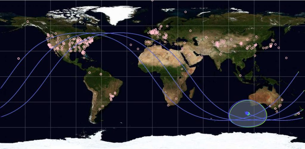
 

PhoneSat Orbit

PhoneSat Orbit

Wondering what phone was used inside these Smartphone NanoSatellites?

The answer is Google-HTC Nexus One running Android Mobile OS. The smartphones were obviously “tweaked” around a bit, pushing the cost of the project components between $3500 to $7000. The smartphones did have fast processors, stable OS, multiple sensors, High resolution cameras, GPS/GNSS receivers and radios! One thing NASA just had to add to the arsenal – “A Larger, external Lithium-Ion battery bank” apart from a stronger radio transmitter.

P.S: We could use one for our smartphones as well, NASA 🙂 Guess its time I wrote to my sister in NASA 😉 Sis, forget the iPhone, get me that Battery bank that you guys have in NASA!!

Here’s the launch details and more information on the project.

Source: NASA

Read on
Search