What is earth’s capacity and how many people can it support?
#Environment

Geography is Broad

planet_earth

This is the second concept of what geography is. Geography is broad. How broad do you say?

Consider this. Geography can be described as having two subfields: Human geography and physical geography.
In addition to have two subfields, geography has many branches: Physical geography, human geography, integrated geography, geomatics, and regional geography. There are also other subjects in relation to geography, not limited to, but including: urban planning and spatial planning.

Physical geography alone covers multiple subjects, such as geomorphology, meteorology, climatology, paleogeography, landscape ecology, and so much more. Physical geography deals natural processes of the earth, as an earth science.Human geography, like physical geography, covers so much material. Economic geography, urban geography, health geography, political geography, and much more.

Human geography takes a look at people, cultures, migration patterns, and it approached as a social science.Only physical and human geography have been discussed thus far, and already, volumes could possibly be written. Consider how much more there is to learn when considering the branches of geomatics, integrated geography, and regional geography. Under geomatics one learns about GIS, cartography, and surveying, and the geomatic subjects can be applied to so many places, such as flight navigation, weather, and urban planning.

And this is just the start.

Geography is very broad, and covers a multitude of subjects. It is much more than memorizing state capitals. Far more than just reading maps. It is about the applications behind it, gaining a broader sense of our world.

Say thanks for this article (0)
The community is supported by:
Become a sponsor
#Environment
#Contributing Writers #Environment #Ideas #Satellites #Science
Using SWOT Mission Data: Monitoring South Asian Rivers During Monsoon Season
Sebastian Walczak & Nikita Marwaha Kraetzig 10.19.2024
AWESOME 0
#Environment #Fun #Science
How LiDAR Technology Helps in Landslide Monitoring?
Sebastian Walczak 04.16.2024
AWESOME 1
#Business #Environment #Ideas #Satellites
China’s Smart Agriculture Boom Has Tech Potential but Requires Affordable Solutions
Nianhua Liu 05.9.2024
AWESOME 3
Next article
#Business #Ideas

Google Buys Smart Travel Guide Start-up Jetpac

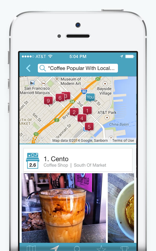
Jetpac geoawesomenessGoogle has bought the travel app startup Jetpac which managed to perfectly combine location and image recognition. Jetpac analyzes location-based images from Instagram using neural networks to match up types of people with locations. This allowed Jetpac to create unique city guides which identify places in a city most frequently visited by various personalities: pet lovers, foodies, business travelers, students, etc. Jetpac CEO Julian Green explained to concept of the app:

JetpacCityGuides_iPhone2You can now search for places to go to in the way that you naturally visualize it, rather than reading through an amenities list or parsing text reviews. People use it to quickly get a sense of a place and the people who go there – photos don’t lie.

So basically speaking “a picture is worth a thousand words”. I totally agree. The question is why Google needs Jetpac? First of all Google has been already experimenting with travel guides apps. Do you remember Field Trip app by Google from 2012? No…? This is why they need Jetpac – to create some really cool city guides which could add another layer on the top of Google Maps.

But that’s not everything. Remember that Google earns over 95% of it’s revenues ($50 bln in 2013) from advertising… Companies including Pinterest and Tumblr are openly admitting to run brand recognition projects using images uploaded by its users. Will Google do the same? We’ll see but imagine what can be done with real-time image recognition and Google Glass… Fascinating and scary.

Read on
Search