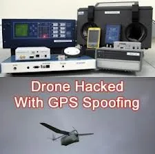
 Geo-location or GPS spoofing can be seen as an attempt to deceive a GPS receiver by broadcasting a slightly more powerful signal than that received from the GPS satellites, structured to resemble a set of normal GPS signals. These spoofed signals, however, are modified in such a way as to cause the receiver to determine its position to be somewhere other than where it actually is, specifically somewhere determined by the attacker (Wikipedia).
This looks like it is gonna be a serious issue for Unmanned Aerial Vehicles (UAVs). The bad guys could leverage this technique and get those military drones fooled and hijacked.
Some smart researchers in University of Texas have demonstrated to the Department of Homeland Security how they successfully hijacked a drone by giving it some bad GPS coordinates.
Every drone or UAV manufacturer should be aware of this drone spoofing and develop systems to counter it.
On a quicker note, i would quickly suggest that UAVs and drones should not reply only on GPS positioning. Systems like the Inertial Navigation System (INS) and Image Matching system could be used to complement the GPS.
Also Geo-Fencing technique could be introduced to give the UAVs geo-referenced boundary control intelligence; anything outside the boundary, there should be an automatic report of a possible spoofing.
The video below may be cool to watch :
Source: mapcite.com


