Geo Addressing Decoded, Part 3: Diving into the Key Features of Precisely’s Geo Addressing System

Precisely has emerged as a leader in address data management, with its Geo Addressing service and the PreciselyID, an elegant system in which every address is assigned a single, unique identifier. This innovation streamlines the management of address data, ensuring accuracy, consistency and reliability.
In our previous articles in this series, we explored the challenges presented by traditional addressing systems, and the advent of technological innovations like geocoding and reverse geocoding, before introducing the powerful capabilities of Geo Addressing. In this article, we will take a deep dive into the sophisticated features of Precisely’s technology and consider how the company is setting new standards in address accuracy.
Eliminating Bad Addresses through Autocomplete, Verification and Validation, Geocoding and the PreciselyID
Bad addressing can cause a host of issues for companies. It can damage relationships with customers through late or lost delivery—as many as one in five hyper local deliveries are cancelled or late due to delivery problems—or by sending out duplicate mail from a database which has been inadequately de-duped. High rates of undelivered or returned items can also cause significant losses. And perhaps above all, bad addresses can lead to reduced operational efficiency through wasted time and resources. It is therefore essential that companies do everything they can to prevent bad addresses from entering the system. Precisely’s technology reduces instances of bad addresses through a sophisticated autocomplete system, combined with address verification and validation, geocoding—and, of course, the PreciselyID.
Read More:
Geo Addressing Decoded Part 1: Why Does Geo Addressing Matter?
Geo Addressing Decoded Part 2: Beyond Coordinates – Exploring the Depth and Impact of Geo Addressing
Geo Addressing Decoded Part 3: Diving into the Key Features of Precisely’s Geo Addressing System
Geo Addressing Decoded Part 4: Exploring the Applications of Geo Addressing Solutions
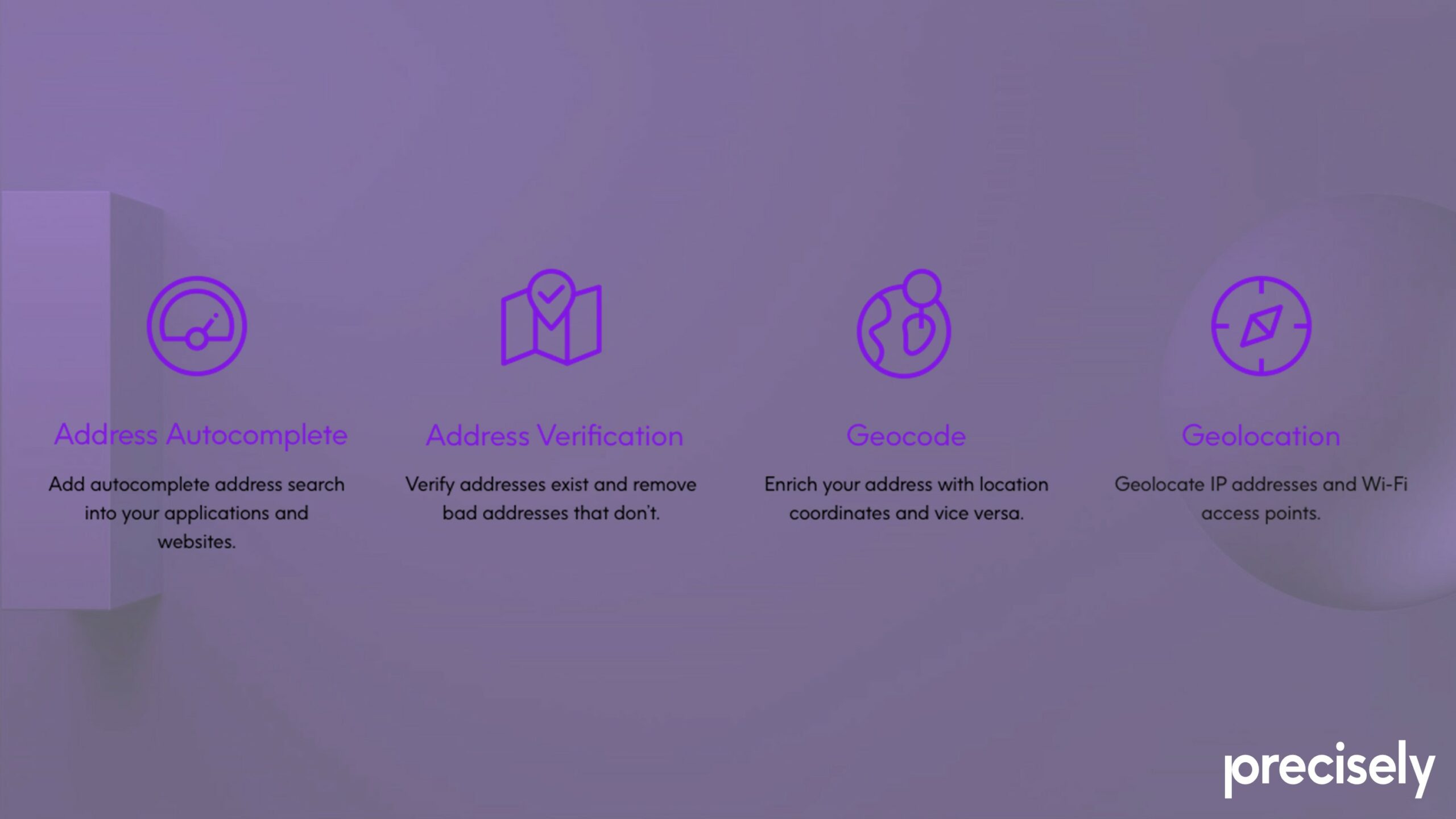
Autocomplete
Address autocomplete is effectively an intelligent form of text prediction. The software takes freeform text entered by a user, performs a search against curated reference data, and retrieves a list of relevant suggestions. The user can then pick from the list of suggestions, and the software cleans up the inputted data, eliminating bad addresses caused by human error.
Faster, more efficient and more reliable address entry also significantly reduces user frustration and abandonment, particularly in online contexts where efficiency is paramount—and in an age when attention spans are at a premium. An astonishing 4% of cart abandonment is due to problematic address entry. Autocomplete improves the user experience by minimizing the effort required to enter address details, leading to higher conversion rates and customer satisfaction.
Address Verification and Validation
These are two related but distinct processes in which the system takes the multi-field address provided by a user and parses it against curated reference data. Simply put, address verification is the process of determining whether an address entered by a user actually exists. Address validation, on the other hand, is the process of determining whether the address is mailable, meaning it can be used for postal purposes. In other words, verification covers both postal and non-postal addresses, while validation is a subset that focuses only on postal addresses.
Both are machine-to-machine processes by which data is cleaned up, and both are essential for eliminating bad addresses and maintaining the quality and reliability of address databases. Precisely’s system uses Universal Postal Union standards to verify address and meet requirements globally, and can verify addresses over 250 countries/territories across different language and character sets.
Geocoding
For some use cases, having an accurate, verified address is enough, but for many industries, real-world positional accuracy is also essential. Delivery and emergency services obviously need this information, but so do insurance companies, for example, which need to know how close a property is to a river or a forest to calculate flooding or fire risks. Addresses therefore need to be linked to a physical location in the world through geocoding. Geocoding is the process of assigning hyper-accurate latitude/longitude coordinates to every address, and attaching a unique ID to it: the PreciselyID.
The PreciselyID
Previous articles in this series have discussed some of the issues with traditional addresses. Multi-field address labels do not fit neatly into our computer systems; US addresses have 13 individual attributes—globally, there are a total of over 300 attributes. Furthermore, addresses change over time. Precisely’s answer to these problems is the PreciselyID: a single, unique and versatile identifier assigned to every addressable location.
Replacing multiple address fields with a single code means the PreciselyID is easier to incorporate into digital infrastructure, more reliable, and more versatile than a multi-field address. It is also permanent and future-proof, as it continues to represent the same location regardless of changes to structure, road names, post codes, or other factors.
Source: Precisely
Location Intelligence through Data Enrichment
However, perhaps the most exciting aspect of Precisely’s system is the fact that it enables users to enrich the data with additional context, allowing them to derive additional insights or location intelligence (LI), and to identify relationships between addresses.
Data Enrichment
By using the PreciselyID identifiers, address databases can be connected to a catalogue of additional information, enhancing both the accuracy and utility of address data for a variety of uses. Addresses can be enriched with over 400 datasets containing more than 9,000 attributes, including points of interest, neighbourhood details, property characteristics, weather data and more. This data enrichment delivers the context necessary to create data-driven strategies based on things like demographics, crime risk, or which houses present opportunities for insurance policies.
The metadata also contains primary and secondary address data—for instance, a primary address like ‘100 Main St’ may have numerous secondary addresses, or ‘children,’ in terms of individual apartments. Metadata can reveal previously unknown relationships like this between address data.
By generating and delivering this metadata, Precisely’s advanced Geo Addressing supports in-depth analysis, and enhances automated decision making. Metadata can also be shared between companies for even greater utility, and third-party data sets can be run through Precisely’s service, to clean up data for machine learning functions, for example.
Unleashing the Potential of Geo Addressing Technology
Precisely’s Geo Addressing solutions are at the forefront of address management, meeting the demand for accurate, reliable, and versatile address data, and providing businesses with the tools they need to navigate the complexities of an increasingly interconnected world.
The comprehensive features of Precisely’s Geo Addressing system offer multiple benefits across various sectors. The system provides improved accuracy, ensuring that address data is accurate and up-to-date, reducing errors and improving overall data quality. It increases operational efficiency by streamlining address entry, verification, and validation processes, saving time and resources for businesses. Perhaps most importantly, it enables enhanced, data-driven decision making, by providing businesses with enriched data and location intelligence.
In our final article, we will focus in more detail on the practical applications of Geo Addressing across different sectors, illustrating how these solutions are transforming industries and meeting diverse needs.
Did you like the article about Geo Addressing System? Read more and subscribe to our monthly newsletter!


#Featured

Next article
The Revolution of True Orthophotos: Precision in Urban Planning, Construction, and Environmental Monitoring
Introduction
In today’s data-driven world, true orthophotos have emerged as indispensable tools, transforming how we visualize and analyze the Earth’s surface. Orthophotos have become integral products in various industries, from urban planning to environmental monitoring.
While traditional aerial photos have long been valuable, they often fall short in terms of accuracy due to distortions caused by topographic relief, lens distortion, and camera tilt.
True orthophotos, on the other hand, provide a distortion-free, accurate map-like view of the Earth’s surface. This article explains the technology behind true orthophotos, their advantages over traditional aerial images, and their applications in various fields.
What Are True Orthophotos?
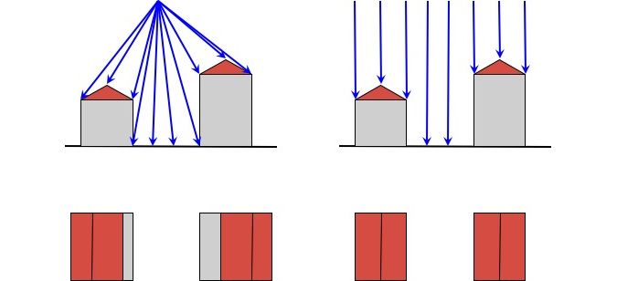
A true orthophoto is an aerial image that has been geometrically corrected (orthorectified) to remove distortions caused by the camera angle and terrain.
This is a view of a given object from a perspective located at an infinite distance from the given object of interest – best shown in the illustration below. The farther from the ground surface, the smaller the distortions. For this reason, high-resolution photos from the satellite ceiling are becoming increasingly popular in creating true orthophotos.
Traditional orthophotos vs. true orthophotos. Source: GIM International
This correction process ensures that the scale of the photograph is uniform, making the true orthophoto an accurate representation of the Earth’s surface, akin to a map.
True orthophotos represent a significant advancement, offering a uniform scale and accurate representation of the Earth’s surface. Unlike traditional orthophotos, true orthophotos account for the three-dimensional shape of the terrain and objects, ensuring that all elements are in their correct horizontal positions.
In traditional orthophotos, shifts of elements protruding above the ground surface, e.g. building roofs, are often visible.
The Technology Behind True Orthophotos
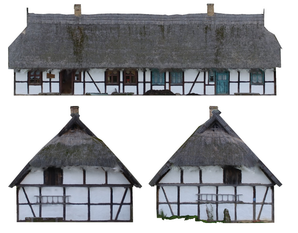
Case study: Keitschick Homestead, Kluki, Poland
To illustrate the process of creating true orthophotos, let’s examine a case study of a historic cottage named Keitschick Homestead from the Slovinian village museum in Kluki, Poland
Creating a true orthophoto involves several steps:
- Image Collection:
- High-resolution images are captured using UAVs (Unmanned Aerial Vehicles) or aircraft equipped with specialized cameras.
- These images are taken at various angles to ensure comprehensive coverage.
- Case study: 122 images of the historic cottage were taken
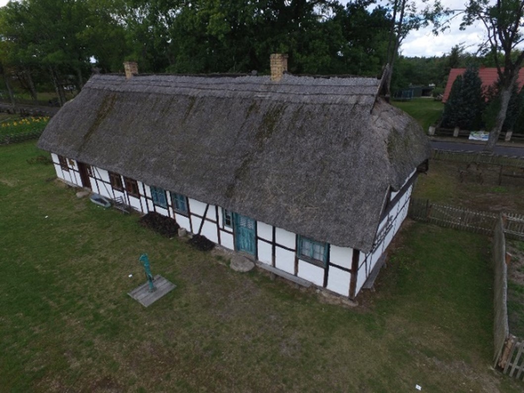
Case study, one of 122 images of a historic cottage, in Poland
- Digital Surface Model (DSM) Creation:
- A DSM is generated from the collected images using photogrammetric techniques.
- This model includes the elevations of terrain and above-ground features like buildings and trees.
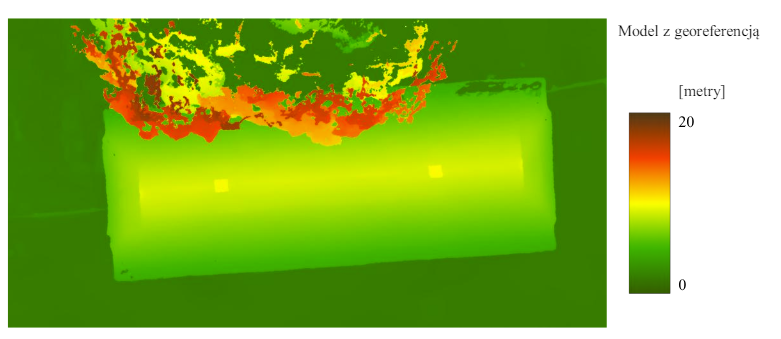
Case study, DSM model
- Orthorectification:
- The DSM is used to orthorectify the images, correcting for distortions and ensuring that all objects are correctly positioned.
- This process involves algorithms that adjust each pixel based on its elevation and position.
- To verify the accuracy of orthophoto and to add georeferencing to the photogrammetric model, the photogrammers use Ground Control Points (GCPs).
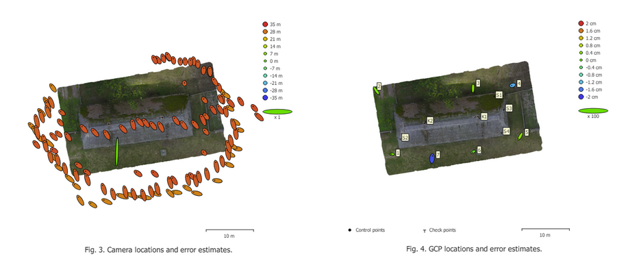
Case-study, camera and Ground Control Points error estimates
- Mosaicking:
- The corrected images are then stitched together to create a seamless orthomosaic.
- Photogrammetric softwares ensure that the overlaps are handled smoothly, and any discrepancies are minimized.
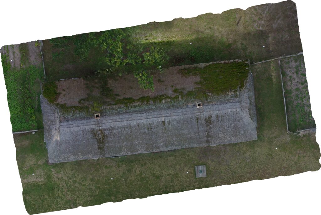
Case-study, final product
For examples of high-quality orthophotos and orthomosaics, visit Maps Made Easy, which showcases impressive samples of these technologies in action.
- Additional products:
- Orthoelevations are a product of photogrammetric processing.
- They can be used as a texture in rendering 3D buildings in virtual reality or simply in conservation.
- The idea is similar while producing true orthophotos, but in this case, the observer stands at an infinite distance from the facade of the building.
Case-study, orthoelevations
Advantages of True Orthophotos
True orthophotos offer several advantages over traditional aerial images:
- Accuracy: True orthophotos provide a highly accurate representation of the Earth’s surface, with a positional accuracy of less than a meter or even several centimeters. This accuracy is crucial for applications that require precise measurements and analysis.
- No Distortion: Unlike traditional orthophotos, true orthophotos do not exhibit distortion from building lean or terrain variations. Every feature is shown from a direct top-down perspective, ensuring consistency and reliability.
- Enhanced Detail: True orthophotos capture fine details such as individual buildings, trees, and other features, making them invaluable for urban planning and detailed land use analysis.
- Consistency: These orthophotos maintain consistency across different datasets, making them ideal for change detection and monitoring over time.
Applications of True Orthophotos
Urban Planning
True orthophotos are useful in urban planning. They provide city planners with precise, up-to-date imagery that can be used to map out new developments, assess infrastructure, and analyze population trends. The accuracy and detail of true orthophotos ensure that planning decisions are based on reliable data.
Construction
In the construction industry, true orthophotos are used to monitor project progress, plan site layouts, and ensure compliance with design specifications. The ability to measure distances and areas accurately from orthophotos helps in resource management and project planning.
Environmental Monitoring
True orthophotos are essential for environmental monitoring. They allow for the detailed observation of changes in vegetation, water bodies, and land use. Environmental scientists use these images to track the effects of natural disasters, human activities, and climate change, facilitating informed decision-making for conservation efforts.
Challenges and Best Practices
While the creation of true orthophotos is straightforward in theory, it involves several challenges:
- Image Overlap: Ensuring sufficient overlap between images is critical. Without proper overlap, gaps and inaccuracies can occur. A general rule is to aim for at least 70% overlap.
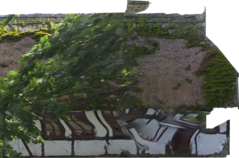
Case-study, the effect of low image overleap may lead to distortions of the final product
2. Lighting and Camera Settings: The quality of images can be affected by lighting conditions, camera settings, and weather. Overcast conditions generally provide the best results, as they minimize shadows and glare.
3. Flight Planning: A well-planned flight path is essential to capture consistent, high-quality images. Adjustments for altitude and speed need to be made to account for varying terrain heights and to avoid blurry images.
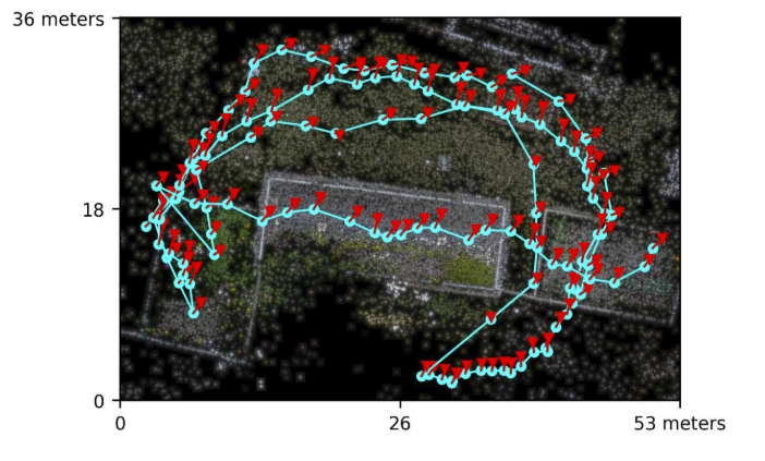
Case-study, post-flight path
Choosing the Right Software
The choice of software for processing orthomosaic maps is crucial. Here are some key considerations:
- Processing Speed: Cloud-based solutions like WebODM often provide faster processing times compared to on-premises software, especially when handling large datasets. This software may process all collected data much faster than manual processing. However, cloud processing may sacrifice some control over the process so the user is not fully protected against the detection of big errors.
- Accuracy: Look for software that offers tools for ground control points and scale constraints to enhance the final product’s accuracy. Correlator3D and Pix4D Mapper tend to produce highly accurate results.
- Stability: Ensure the platform is reliable and capable of handling large projects without crashing or errors. Cloud-based solutions often provide better stability.
- Ease of use: User-friendly interface can significantly reduce the learning curve and streamline workflows. WebODM is relatively easy to use once set up, while Correlator3D offers automated templates.
Summary
True orthophotos represent a significant advancement in the field of aerial imaging. Their accuracy, lack of distortion, and high level of detail make them invaluable tools in various industries, including urban planning, construction, and environmental monitoring.
By leveraging advanced technologies and following best practices, true orthophotos provide precise, reliable data that supports informed decision-making.
For those interested in exploring the capabilities of true orthophotos, Maps Made Easy offers excellent examples and resources to get started. As technology continues to evolve, the applications and accuracy of true orthophotos will only improve, further solidifying their role as essential tools in modern geospatial analysis.
More about ortho imagery you can find in our article: What is the difference between orthophotos, orthophotomaps, orthomosaics and true orthophotos?.
Did you like the article? Read more and subscribe to our monthly newsletter!

