From Cloud Buckets to Maps: Modern Tools for Streaming and Visualizing Raster Data

Geospatial datasets are growing larger, and cloud-native storage is becoming the norm. This means that professionals working with raster data face a common challenge: how to efficiently access, organize, and visualize massive collections of satellite imagery, terrain models, and other raster formats that now live in Amazon S3, Google Cloud Storage, or Microsoft Azure.
The introduction of Cloud Optimized GeoTIFFs (COGs) and the SpatioTemporal Asset Catalog (STAC) standard has made it easier to store and organize this data. However, turning this data into useful insights is still challenging. Right now, there’s a lot of work being done to connect the information stored in the cloud with easy-to-use map-based tools. This is happening both in open-source projects and commercial platforms.
This article looks at the current state of raster infrastructure. It also explores some noteworthy tools, including Felt, Titiler, and others, that aim to streamline the workflow from cloud bucket to web map.
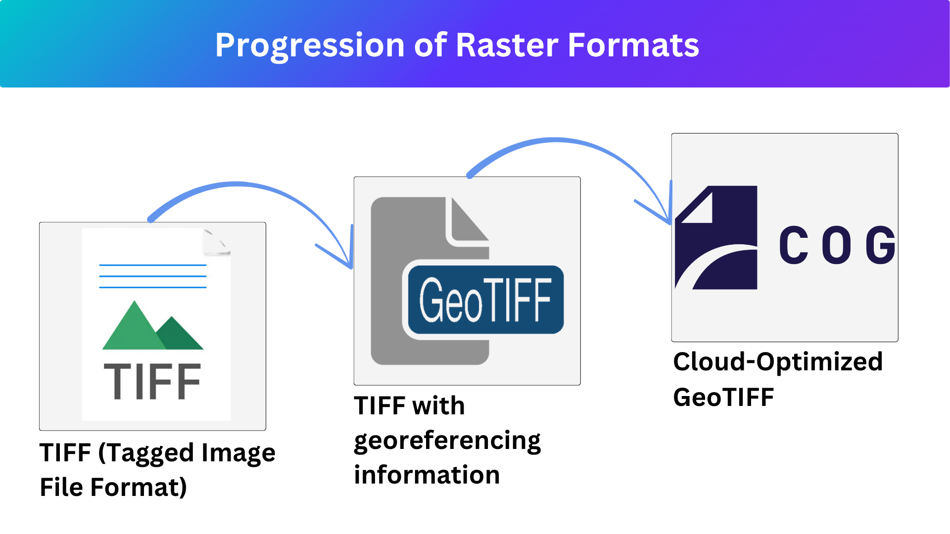
What Are Cloud-Optimized GeoTIFFs?
Cloud-Optimized GeoTIFF (COG) is a special type of GeoTIFF file structured to allow efficient access over the internet. It uses internal tiling and overviews, enabling users to stream only the needed portions of large raster datasets without downloading the entire file—ideal for web mapping and cloud-based analysis.
STAC: The Standard Helping Structure Cloud Data
A key piece of the puzzle is the STAC standard, which structures metadata about geospatial assets in a machine-readable, spatially-aware catalog. STAC has become a widely adopted convention for organizing Earth observation data and underpins many modern data portals, including those run by NASA, USGS, and Radiant Earth.
By allowing datasets to be filtered by location, date, sensor, and more, STAC simplifies discovery. But STAC itself doesn’t handle visualization or streaming – it’s one part of a larger pipeline.
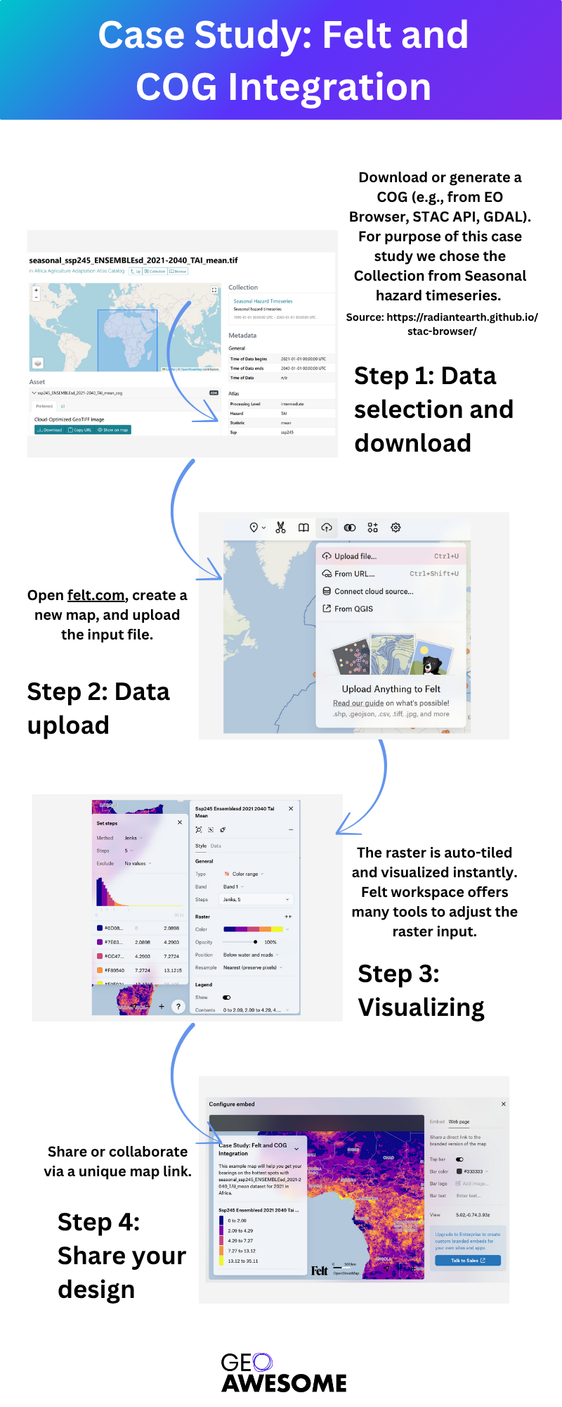
Case Study: Felt and COG Integration
This case study was inspired by Geoawesome’s meeting with Felt’s experts, which provided valuable insights into their platform and upcoming features. More details can be found here:
Overall, the integration process was straightforward and seamless.
Beyond Raster: The role of new formats
COG and STAC have made it easier to access and visualize cloud-native raster data. At the same time, a similar change is happening in the world of vector data:
New formats like GeoParquet, FlatGeobuf, and Apache Iceberg are becoming popular alternatives to traditional OGC APIs. As Ingo Simonis (Open Geospatial Consortium) recently outlined in
two thought-provoking posts, these formats are making geospatial infrastructure more modern, scalable, and ready for analytics.
New formats:
- GeoParquet aligns geospatial data storage with the analytics-first world of big data and data lakes.
- FlatGeobuf is simpler and faster for browser-based applications and desktop GIS tools.
- Apache Iceberg introduces versioning, time travel, and better support for cloud data warehouses.
- These formats don’t directly replace OGC APIs—but complement them by offering faster, more flexible ways to store, query, and process large-scale vector data.
These trends are similar to the change we’ve seen in raster data: from static files to streamed, searchable resources that are designed for the cloud. As raster and vector formats improve, expect them to work more closely together. This will happen as cloud-based data, APIs, and real-time geospatial applications are developed.
Other Cloud-based Tools Platforms
To enable full raster workflows in the browser or desktop, several tools and platforms have emerged in recent years. Here are a few noteworthy ones:
- Felt
A more recent addition to this landscape, Felt focuses on turning cloud-stored COGs into interactive, styled map layers without writing code. It connects directly to S3, GCS, or Azure Blob and indexes files into a spatial catalog that supports metadata filtering, NDVI analysis, hillshading, and styling. While it abstracts infrastructure complexity, it is a commercial platform and may not offer the same flexibility as open-source tools.
Website: https://felt.com
- titiler (Ti-Tiler)
Titiler was created by Development Seed. It is a backend for serving raster tiles that is based on Python. It can be used directly from COGs. It supports STAC input, performs dynamic tiling, and exposes endpoints that can be used in Leaflet, MapLibre, or other clients. It’s powerful, but it requires some setup and server management.
GitHub: https://github.com/developmentseed/titiler
- OpenEO Platform
It is designed for analytical workflows and connects clients to large-scale Earth observation backends (like Copernicus Data Space Ecosystem, Google Earth Engine, or Sentinel Hub). While it’s not as focused on visualization, it’s great at processing raster data in the cloud using standard APIs.
Website: https://openeo.cloud/
- Radiant Earth STAC Browser
Designed for navigating STAC catalogs, Radiant Earth’s browser is minimal but effective. It doesn’t include visualization, but it helps users understand and query cloud-native datasets using the STAC standard.
Website: https://radiantearth.github.io/stac-browser/#/
Conclusion: An Evolving Landscape
We’re in the middle of a transformation in how geospatial raster data is accessed and visualized. Cloud-based tools are taking steps to abstract complexity and bring cloud-native data to life on the map. But the field is still evolving, and no one solution fits all use cases.
The geospatial community stands to benefit enormously from continued collaboration on open standards, shared libraries, and interoperable services. Whether you’re a developer, data scientist, or GIS analyst, now is the time to experiment, contribute, and help shape the future of cloud-native raster workflows.
Beyond Raster: The role of new formats
COG and STAC have made it easier to access and visualize cloud-native raster data. At the same time, a similar change is happening in the world of vector data:
New formats like GeoParquet, FlatGeobuf, and Apache Iceberg are becoming popular alternatives to traditional OGC APIs. As Ingo Simonis (Open Geospatial Consortium) recently outlined in two thought-provoking posts, these formats are making geospatial infrastructure more modern, scalable, and ready for analytics.
New formats:
- GeoParquet aligns geospatial data storage with the analytics-first world of big data and data lakes.
- FlatGeobuf is simpler and faster for browser-based applications and desktop GIS tools.
- Apache Iceberg introduces versioning, time travel, and better support for cloud data warehouses.
- These formats don’t directly replace OGC APIs—but complement them by offering faster, more flexible ways to store, query, and process large-scale vector data.
These trends are similar to the change we’ve seen in raster data: from static files to streamed, searchable resources that are designed for the cloud. As raster and vector formats improve, expect them to work more closely together. This will happen as cloud-based data, APIs, and real-time geospatial applications are developed.
Dear Reader, did you like this article? Which tool should we test next time? Write your ideas to one of our members: sebastian@geoawesome.com.


#GeoDev
Next article

We’re excited to announce that Sebastian from the Geoawesome team will attend the Living Planet Symposium 2025 in Vienna! This major event, organized by the European Space Agency, brings together the Earth observation, GIS, and academic communities to explore the latest advances in satellite data, climate research, and geospatial innovation.
Are you also attending? Let’s connect!
Drop us an email at sebastian@geoawesome.com or connect directly on LinkedIn.
Our Team Member, Sebastian, will also be presenting a scientific poster at the event, highlighting his research on the application of InSAR and LiDAR techniques in post-mining regions. His presentation will be featured during the poster session in X area on Tuesday, 24 June from 17:45 to 19:00. Session name: B.04.01 – POSTER – Satellite based terrain motion mapping for better understanding geohazards.
He will be glad to meet Geoawesome fans and connect with fellow enthusiasts from the geospatial community.
Engage with our geoawesome community!
We’d love to feature your perspective in a special Geoawesome community blog post after the symposium. Let’s show the world how awesome Earth observation really is.
Take a picture during the event, and send it to us. Tell us what you think about the event and the EO landscape. See you on the Living Planet Symposium and let’s connect!
#LivingPlanetSymposium #LPS2025 #Geoawesome #EarthObservation #Vienna2025 #ESA
Read more and subscribe to our monthly newsletter!

