From Accuracy to Action: How HD Satellite Data and AI Are Revolutionizing Navigation for Emergency Response and Logistics

As our reliance on navigation systems continues to grow, the demand for accurate and real-time data has never been greater. All users of navigation data, be they casual or professional, have come to expect their maps to be accurate, updated, and easy to use, with a matching seamless satellite imagery overlay. However, the importance of accurate navigation systems is most evident in industries where speed of response is critical, like emergency services and logistics. They are essential for moving quickly and safely through changing environments to meet tight delivery schedules or get to people in need; outdated or incomplete data can lead to errors, delays, or even loss of life.
In response to this evolving need, high-definition (HD) maps have become increasingly important for providing precise, relevant information, transforming maps from static objects into a dynamic, near real-time system. However, creating and maintaining these high-precision maps comes with considerable challenges, especially in rapidly shifting urban environments and areas of significant population change.
The Growing Need for Accurate and Up-to-Date Maps
First responders and emergency services often operate in urban environments that are constantly changing—road layouts and infrastructure are in a permanent state of development, and construction zones often pop up with little warning. For a fire truck or ambulance responding to an emergency, a short delay caused by an outdated map can be the difference between life and death—in fact, numerous studies have shown that a response time of mere minutes can have a significant impact on patient survival rates.
Logistics and delivery companies face the same problems, albeit with less dramatic stakes. With the rise of ecommerce and next-day (or same-day) delivery, the logistics industry increasingly depends on efficient pick-up and drop-off to keep deliveries on time and to meet ever higher customer expectations. For example, in an Ipsos survey of 2022, 85% of online shoppers said a poor delivery experience would prevent them from ordering from a retailer again. Small delays can therefore lead to big financial losses.
To meet these needs in today’s fast-paced world, maps need to be updated proactively, rather than reactively. Traditionally, mapping companies have relied on a global network of employees, mobile mapping, and user feedback for generating map updates. Proactive change detection is possible with these methods, but it can be time consuming. Earth observation space-based technology is poised to play a vital role in keeping maps updated by supplementing these data sources with specific areas of change.
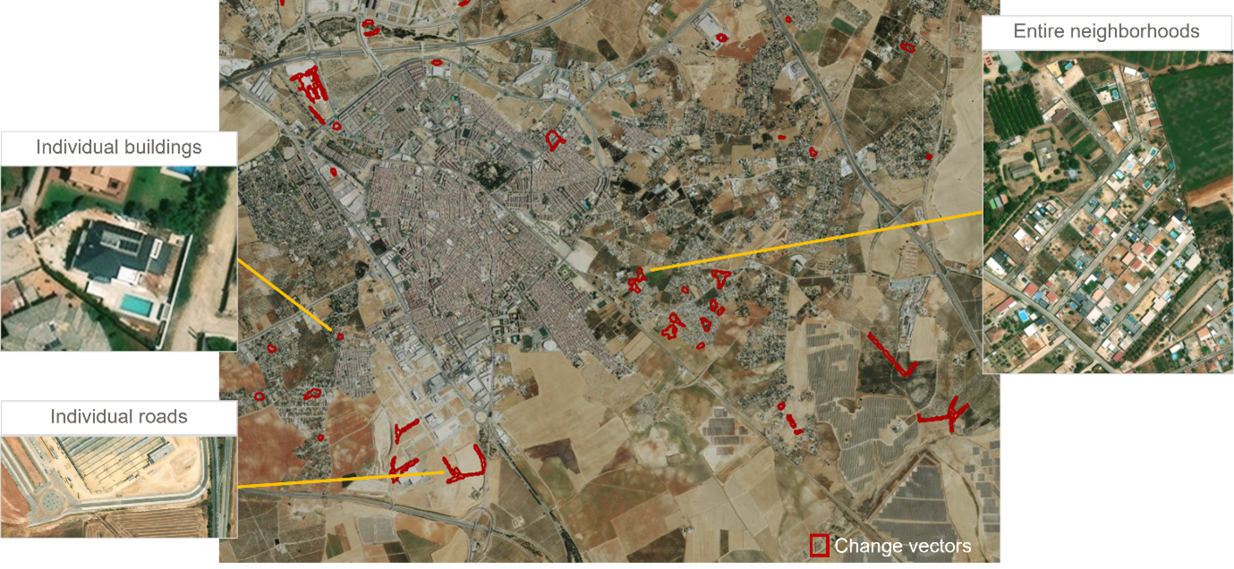
Maxar’s Building and Road Change is a cutting-edge vector product that provides insights on areas with map-relevant change.
The Competitive Edge of Satellite Data in Navigation
Satellite imagery has been providing context for navigation systems for many years, offering a broad view of the Earth but without the granular detail needed for real-time decision-making. However, this is rapidly changing: “Satellite data has evolved from being a static backdrop to a dynamic, integral part of mapmaking,” says Luca Perletta of Maxar, a leading provider of secure, precise geospatial insights. “With the latest advancements, we can now detect changes in infrastructure almost in real-time, allowing us to keep maps updated with unprecedented accuracy.” By facilitating the move from reactive mapping to proactive updates, satellite imagery, supported by artificial intelligence (AI), is redefining the mapmaking process, enabling maps to be updated dynamically and on a larger scale than ever before.
Maxar’s constellation of very high-resolution satellites is playing a critical role in this transformation. They have the ability to collect 30 cm-class resolution imagery—which can be further enhanced to 15 cm HD using super resolution models. As Maxar’s Josh Winer notes, “15 cm satellite imagery offers a level of detail that was previously only achievable with aerial photography.”
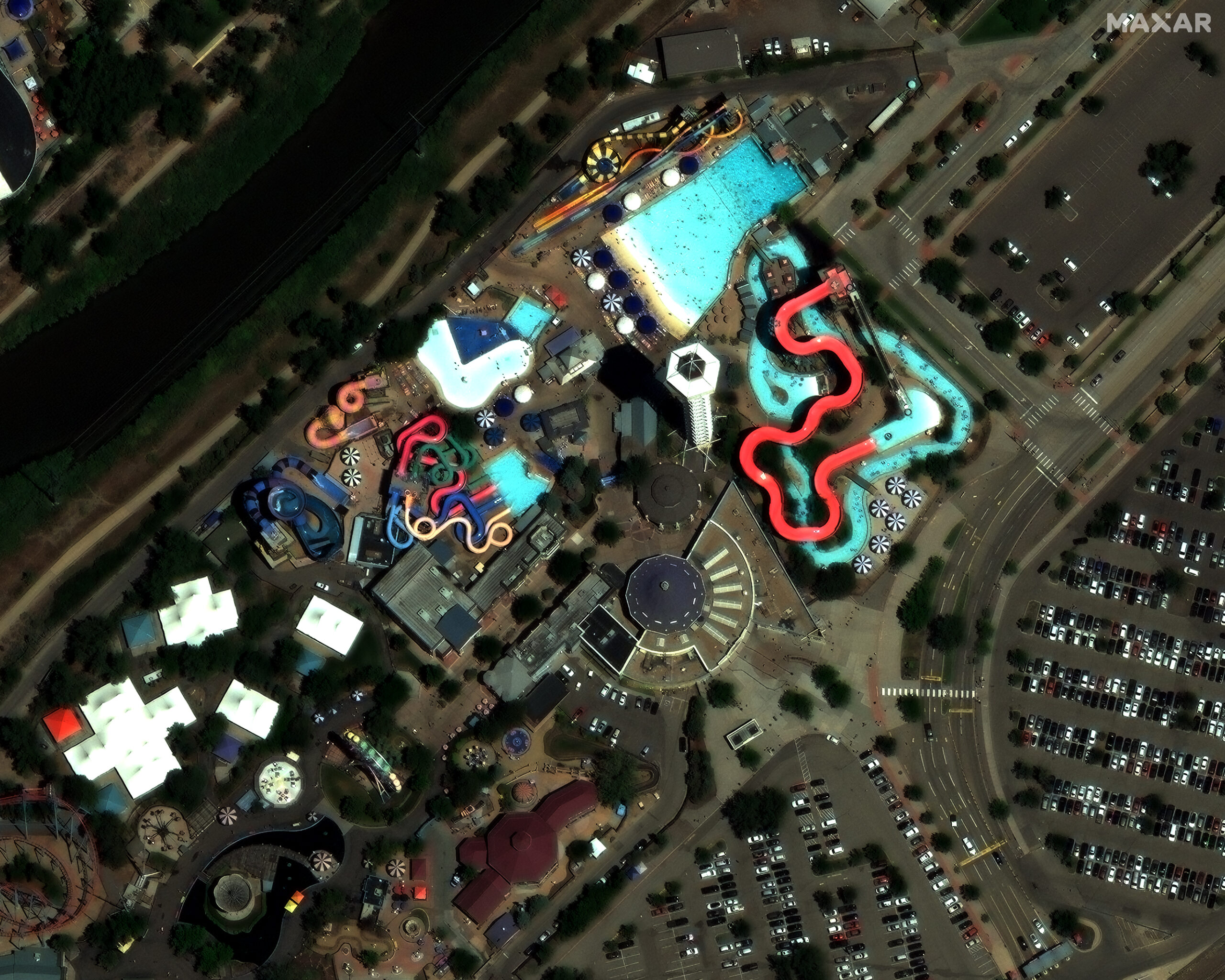
This Maxar satellite image of Denver, Colorado, in 15 cm HD resolution shows incredible details such as sidewalks, individual parking spaces, theme park structures, and even people enjoying the swimming pool.
Satellite imagery can be used to identify construction zones and other infrastructure changes in near real-time. Significantly, it can also identify the extent of road closures and other features not visible from common conventional sources like dash cams. This level of speed and precision “is essential for identifying road features and environmental changes that are critical for the safe operation of emergency services,” says Winer. It also improves efficiency for logistics companies.
Proactive Change Detection: Crucial for Navigation Systems
In the words of Perletta, “The future of navigation services lies in our ability to anticipate and adapt to changes in the environment.” As urban landscapes rapidly evolve, the ability to detect and anticipate changes before they impact navigation systems is increasingly critical, and satellite data, augmented with AI, offers a powerful solution through proactive change detection.
Maxar’s system uses AI change detection models to constantly analyze a feed of low resolution satellite imagery, identifying any changes that occur. When changes are detected in an area of interest, Maxar tasks its very high-resolution satellites to collect fresh imagery of the area to confirm and provide additional details about the change.
“The integration of high-resolution satellite data with AI-driven analytics is revolutionizing the way we create and maintain maps for navigation,” says Winer. It allows mapmakers to proactively adjust to new developments—detecting new roads, bridges or buildings before they have been completed. “This proactive approach is crucial for ensuring that navigation maps are as accurate and up to date as possible.”
This is a game-changer for navigation systems used by emergency services or logistics. It ensures that any user of navigation information, whether a fire truck navigating through new neighborhoods or a delivery driver rerouting around construction zones, always has access to the most current data, significantly reducing the risk of delays or errors during their operations. Moreover, the ability to provide additional contextual information, such as up-to-date details on urban development or environmental hazards, adds an extra layer of intelligence to navigation systems, improving safety as well as efficiency.
Next-Generation Navigation Systems
The integration of high-definition satellite data and AI is paving the way for the next generation of navigation systems. With proactive change detection and dynamic updates, these tools have the potential to provide industries like emergency response and logistics with a radically improved driving and navigation experience. By reducing the reliance on manual change detection techniques and introducing a real-time approach to mapmaking, they will be able to operate more efficiently and safely than ever before, while also saving valuable resources. From emergency services reaching critical locations faster to delivery companies optimizing their routes with unprecedented accuracy, the future of navigation lies in this powerful combination of technology.
However, these are far from being the only sectors to benefit from these technological developments. Indeed, any company, service provider or industry looking to remain competitive should be exploring the different ways in which satellite imagery and AI can be harnessed to improve their navigation systems and improve efficiencies, ultimately benefiting end users and customers. The continued advancement of satellite data, combined with AI, holds the potential to revolutionize navigation systems in more ways than we can yet imagine.
Learn more about Maxar at www.maxar.com


#GeoAI


Next article
Lighting Up the World with LiDAR: An Overview of the Industry and Its Possibilities
From autonomous vehicles navigating busy city streets to archaeologists discovering ancient cities buried beneath thick canopies, LiDAR (Light Detection and Ranging) technology is redefining how we perceive the world around us. In just a few decades, what began as a niche remote sensing method has transformed into one of the most promising and dynamic tools in the geospatial industry.
This article takes a look at the current landscape of this industry, showcasing its most innovative applications, global-scale projects, and online resources that make it more accessible and interactive than ever before.
What Makes LiDAR Unique?
LiDAR is a remote sensing method that uses laser pulses to measure distances. Mounted on drones, airplanes, vehicles, or even handheld devices, it captures the shape of the Earth’s surface, buildings, vegetation, and other objects in 3D with exceptional accuracy and resolution.
What makes LiDAR stand out is its ability to “see” through dense vegetation and even some water surfaces, its independence from sunlight (unlike photogrammetry), and its capability to generate highly detailed digital elevation models (DEMs) and 3D point clouds. That makes Aerial Laser Scanning (ALS) great for mapping static environments and detecting change over time.
Use Cases of LiDAR
Global Projects Leveraging LiDAR at Scale
Challenges and Frontiers
Despite its powerful capabilities, LiDAR is not without limitations. Data acquisition can be expensive, and processing massive point clouds requires significant computing resources. Interpretation of raw LiDAR data also requires domain expertise.
However, advances in machine learning, cloud computing, and edge processing are making aerial laser scanning data easier to manage and analyze. Real-time point cloud classification and segmentation are becoming more accessible, opening new doors for automation and AI-powered insights.
Geoawesome Landscape: LiDAR Companies and Startups
A curated section featuring the leading LiDAR-sensor manufacturers, data processing startups, and AI innovators transforming the this industry.
Conclusion: Lighting the Way Forward
The use of LiDAR is expanding beyond the confines of scientific laboratories and niche surveying companies. This technology is fundamental to innovation in a wide range of fields, including environmental science, transportation, disaster management, and archaeology. Its capacity to produce precise 3D models of the world has led to novel approaches in analyzing, managing, and safeguarding our planet.
As access to aerial data becomes more widely available through open platforms and cloud services, the technology’s impact will continue to expand.
How do you like this technology? Share your thoughts! Read more and subscribe to our monthly newsletter!

