Urban Planning’s New Frontier: The Transformative Power of Satellite Imagery
Editor’s note: This article was written as part of EO Hub – a journalistic collaboration between UP42 and Geoawesome. Created for policymakers, decision-makers, geospatial experts and enthusiasts alike, EO Hub is a key resource for anyone trying to understand how Earth observation is transforming our world. Read more about EO Hub here.
Urban planning has undergone a remarkable transformation over the past half-century, driven largely by revolutionary advances in satellite technology and geospatial analysis. What once required months of ground surveys and manual mapping can now be accomplished in days or even hours, with unprecedented accuracy and detail. This technological leap has arrived at a critical moment in human history, as cities worldwide grapple with unprecedented growth, environmental challenges, and the pressing need for sustainable development.
In this article, we’ll explore the transformative role of satellite imagery in urban planning, from its historical foundations to its current applications and future potential.
What Did We Do Before Satellite Imagery?
Before the advent of aerial and satellite technology, urban planners relied heavily on ground-based surveying techniques that were inherently time-consuming and labor-intensive. It was only in the early 20th century when urban planners started to gain access to traditional aerial photography which allowed them to view cities from above. This new perspective was a significant step forward because, for the first time, urban planners could gain real contextual awareness of the terrain, collecting information on land use, agricultural management, forestry, pollution and conservation, wildlife management, and much more. However, it was still quite expensive, offered limited coverage, and suffered from many of the challenges that come when your datasets are fragmented and incomplete.
This made it difficult to integrate different data sources and consider complex planning scenarios – reducing the speed, scale, and comprehensiveness of any development projects. These constraints often resulted in reactive rather than proactive planning approaches, as planners lacked the tools to effectively monitor and predict urban growth patterns. Interventions based on incomplete information have been shown to exaggerate various unexpected externalities that could have been avoided if the right data was more accessible.
In recent years, we’ve seen a lot of progress with platforms like UP42 starting to aggregate these services and resources, enabling them to offer aerial imagery affordably and at a very high resolution, making many of these use cases more accessible for urban planners of all kinds. This has made a significant difference to how urban planners work and it often serves as a gateway to satellite-based imagery which has gone on to fundamentally transform the practice of urban planning, ushering in a new era of data-driven decision-making and comprehensive spatial analysis.

Modern Applications of Satellite Imagery for Urban Planning
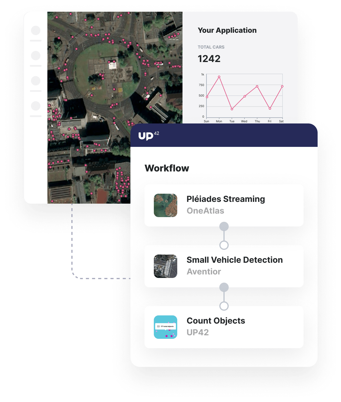
Satellite imagery has emerged as an indispensable tool in modern urban planning, offering planners and decision-makers a dynamic, bird’s-eye view of urban landscapes that can be analyzed across multiple temporal and spatial scales. At the forefront of this technological revolution are high-resolution optical satellites such as Pleiades which can capture images with resolutions as fine as 50cm, allowing planners to discern individual trees, cars, and even smaller urban features. This level of detail has transformed how we approach urban analysis, enabling precise measurement of building footprints, accurate assessment of infrastructure conditions, and detailed monitoring of urban development patterns.
However, optical imagery represents just one facet of satellite technology’s contribution to urban planning. The introduction of Synthetic Aperture Radar (SAR) has provided planners with capabilities that would have seemed like science fiction just decades ago. Unlike optical sensors, SAR can penetrate clouds and operate in darkness, offering consistent monitoring capabilities regardless of weather conditions or time of day. This technology has proven invaluable for monitoring urban subsidence, tracking structural deformation, and assessing flood risks – critical capabilities in an era of increasing climate uncertainty.
These technological capabilities have found practical application in countless urban planning initiatives worldwide. Cities are using satellite-derived data to optimize public transportation routes, plan green corridors, and assess the impact of new developments on local ecosystems. The technology has proved particularly valuable in rapidly growing urban areas, where traditional planning methods struggle to keep pace with development.
Another common use case is to monitor urban expansion and its environmental impacts. Planners can track changes in vegetation cover, identify areas of informal settlement, and assess the effectiveness of green space initiatives. This information has proven invaluable for creating more sustainable and resilient urban environments.
Lastly, the integration of these various satellite technologies has led to profound changes in how we approach land use and land cover analysis. Where once planners relied on infrequent surveys and educated guesswork, they can now monitor urban change in near-real-time. This capability has proven particularly valuable in rapidly growing cities, where understanding the pace and pattern of urban expansion is crucial for sustainable development.
All of these applications are enabled not just by the access to high-quality satellite imagery from platforms like UP42, but also by improvements to how this data can be analyzed and applied to urban challenges. By connecting to the UP42 API, urban planners can integrate different data sources, run sophisticated analyses, and validate those results without having to have all the computational power on-site. This drastically improves their ability to scale their work and goes a long way to improving decision-making across a wide range of different metrics.
What Will the Future of Urban Planning Look Like?
The coming decade promises a remarkable evolution in satellite technology that will further redefine our capacity for urban observation and analysis. New constellation systems, comprising hundreds of small satellites working in concert, are set to provide near-continuous monitoring of urban areas. These systems will overcome one of the most significant limitations of current satellite technology: temporal resolution. Instead of capturing images every few days or weeks, these constellations will offer multiple daily passes over urban areas, enabling near-real-time monitoring of urban dynamics.

The advancements in sensor technology have the potential to be equally revolutionary. Next-generation sensors could offer unprecedented spectral and spatial resolution, capable of detecting subtle changes in urban environments that current systems might miss. Hyperspectral sensors with hundreds of spectral bands will provide detailed material composition analysis, while improved thermal sensors will offer precise monitoring of urban heat patterns and energy efficiency at the building level.
However, perhaps the most transformative development lies not in the satellites themselves but in how we process and analyze their data. Artificial intelligence and machine learning algorithms are becoming increasingly sophisticated in their ability to interpret satellite imagery. These systems will be able to automatically detect and classify urban features, monitor changes, and even predict future development patterns with remarkable accuracy. This automation is particularly significant given the enormous volume of data that new satellite systems will generate – and platforms like UP42 are building capabilities to bring that power to anyone who needs it. AI-powered analysis systems will be capable of processing this data in real-time, alerting planners to significant changes or emerging patterns that require attention. For instance, these systems might automatically detect unauthorized construction, monitor traffic patterns, or identify areas of environmental stress before they become critical issues.

Of course, these technological advances will bring their own challenges. The increasing volume of data will require new approaches to data management and analysis. Privacy concerns will need to be addressed as the resolution and frequency of satellite monitoring increase.
There will also be a growing need for professionals who can bridge the gap between technical expertise and practical urban planning applications. However, if we can thoughtfully integrate them into our existing planning processes and societal norms, the potential is immense. The goal is not to replace human judgment but to enhance it with better data and more sophisticated analysis tools. The cities of the future will be shaped by planners who can effectively combine technological capabilities with human insight and local knowledge.
What Does It Mean for the World?
The future of satellite imagery in urban planning is not just about providing better technology – it’s about creating more livable, sustainable, and resilient cities. As these technologies continue to evolve, they will provide unprecedented opportunities to address urban challenges and create better urban environments for future generations.
Most excitingly, it democratizes access to cutting-edge data that can be used to make holistic decisions. For geospatial professionals, this evolution means moving beyond traditional roles as data collectors and mapmakers to become key strategic partners in urban development. The ability to monitor, analyze, and predict urban changes in near-real-time positions these experts at the forefront of addressing some of humanity’s most pressing challenges.
This technology can be a catalyst for significant positive change if we can leverage it to its full potential. As a community, we’re excited to see how insights will help to manage resource allocation, mitigate climate impacts, and ensure equitable development. When working at their best, these technologies enable evidence-based decisions that can improve millions of lives. And as platforms like UP42 make these tools more accessible, communities and stakeholders can participate more meaningfully in planning processes, armed with the same powerful data as traditional decision-makers.
This technological revolution isn’t just about building better cities – it’s about fostering more inclusive, sustainable, and resilient urban futures for us all. And we can’t wait to see what can be unlocked as the industry continues to grow and evolve.
Did you like the article? Read more and subscribe to our monthly newsletter!


