Remotely sensed evapotranspiration to manage water in arid regions
Water in Agriculture:
Agriculture productivity and water consumption are tightly coupled and the picture is vivid in the arid or semi-arid region. For an instance, agriculture in general and irrigation in particular consume over 80% of the freshwater used in Saudi Arabia (KSA). The most bothering massage is, the rainfall in KSA is now only a few centimeters (about one inch) each year which is negligible. Besiedes, there are no surface water which left them with only one choice; using groundwater which is a non-renewable resource.
Although no one knows how much water is beneath the desert, hydrologists estimate it will only be economical to pump water for about 40 years. After that? So, in arid regions, sustainability put lots of ongoing activities in question. Should KSA stop Agriculture? should they adopt some intelligent irrigation system? Should they try some new crop culture or crop rotation or something more intelligent than that?
I don’t have a confident answers to those question right now but one thing I know for sure. In arid or semi-arid region, any attempt to improve water use efficiency in irrigated agriculture must be based on reliable estimates of seasonal/total evapotranspiration (ET), which has a major impact on water management. Continuous monitoring of both, current status of crop growth health and ET built the basis for the optimization of irrigation and water management.
Now a days, there are some significant efforts been going on in the middle eastern countries on recharging groundwater by injecting desalinize water from the sea, which is extremely expensive and might trigger other land management problem like increasing rate of soil salinity. On the other hand, the idea of artificial groundwater recharge by intelligent irrigation system (i.e., irrigating near the root not on the surface) may improve the groundwater recharge rate efficiently. To get a grip on such idea we need Actual Evapotranspiration (AET) information. Because in KSA precipitation is negligible and there is no surface water so only water source is groundwater which can be computed using monitoring the gravity field by Grace satellite. On the other hand we know how much water is needed per ton of yield of different crops and then if we know the AET, it would be possible to accurately estimate the amount of potential water to recharge the groundwater. And, I also believe, investment on intelligent irrigation would be cheaper then injecting desalinize water to increase the groundwater recharge rate, in the long run.
Actual Evapotranspiration and Remote Sensing:
There are couple of approaches have been developed over the last 25 years to estimate spatially distributed AET from the data collected by remote sensing. One of the very popular method is called SEBS (Surface Energy Balance System) for land which provides a way to estimate and monitor AET just by solving surface energy balance. The main idea is, if we know the net radiation (Rn) at the surface, the rate of heat storage into the soil and vegetation (G) and the of heat loss to the air (H) due to surface air temperature difference we can say ET = Rn – G – H because the rest energy (Rn – G – H) is consumed to evaporate water from soil and plants. All these parameters can be estimated by remote sensing data using some weather station data like wind speed, relative humidity, air pressure and air temperature.
Satellite Derived Actual Evapotranspiration in KSA:
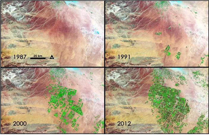
Before 1987, in KSA one of the major crop was wheat which consumes huge amount of water in respect of other crops. To increase the water productivity the KSA government has stopped the subsidies on wheat to reduce the wheat production and that resulted the increase the production of alfalfa. unfortunately, that requires more water then wheat. So, the water consumption scenario did not change but get worse and growing population pushed the rate of growing number of fields and that pushed the water consumption line.
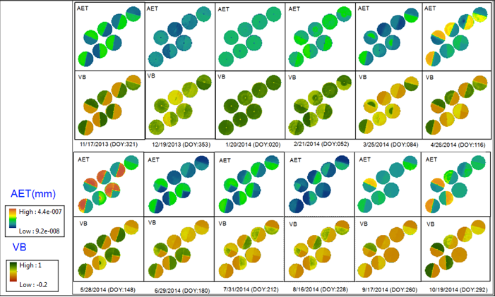
The basic theory is Vital Biomass (VB) represents the crop productivity and crop productivity is linked to the water consumption by plant. And AET represents the water loss by ET and rest of the water can be considered as the potential water to recharge the groundwater. In the figure, we can see the AET and VB of different dates, which shows the change of water productivity in different months, in such sense:
i) the VB is higher but the AET is lower results higher water productivity (in month January) and less crop production cost in terms of water
ii) higher VB and higher AET results lower water productivity (in month October) and higher crop production cost in terms of water.
from these we can derive an optimization function of water consumption and crop productivity to introduce more efficient crop and water management plant.
The other side of the coin is the irrigation and groundwater recharge. If we assume the irrigation is constant over months, we can say the potential amount of water to recharge groundwater is higher in January and lower in October. The same way we also can derive and spatio-temporal groundwater recharge function for irrigation.
These understanding also have policy implication. For an instance, KSA can improve the water productivity and efficiency by introducing/promoting seasonal agriculture. for an example, In January, they can grow crop which requires relatively more water like cereal and in October they can grow draught tolerant crop or no crop.
Did you like this post? Read more and subscribe to our monthly newsletter!


