New GPS Tracking Bullet May Render High-Speed Police Chases Obsolete

GPS Tracking - gpstrackingbulletPolice departments around United States are experimenting with a new high-tech solution that avoids dangerous high-speed pursuits by firing a tracking device at a fleeing vehicle and using a GPS tracking service to electronically “follow” suspects from a safe distance. It’s called the “StarChase” GPS locator system and it appears to have brought high-tech gadgetry inspired by science fiction into the real world.

The new technology is praised by police as a much welcomed leap forward in law enforcement capabilities, and derailed by civil libertarians as one more example of “big brother” restricting the freedoms of ordinary citizens yet again.

Law enforcement officials claim that using StarChase technology can save lives by reducing the need to engage in high-speed pursuits of criminal suspects. They cite the elevated levels of danger to police officers, suspects, and the general public during high-speed chases as why there’s a need for tracking GPS technology. All police have to do is fire a compressed air launcher mounted in the grill of police cruisers that are loaded with a GPS tag embedded in a projectile coated with an industrial adhesive that attaches itself to the targeted vehicle.

Once the device is attached, GPS tracking software is able to trace the movements of the vehicle without the need for a police unit to continue the pursuit. Police can actually back off of suspects, hopefully giving them a false sense of security, allowing them to slow down to safer speeds thinking that they’ve made a clean getaway. Meanwhile, law enforcement is actually fully aware of their exact location and will, again hopefully, track them back to their home or base of operations. Once the vehicle is no longer in motion the police can move in and make the arrest.

It all sounds pretty good to most people, unless of course you’re a civil libertarian who believes that having the ability to electronically track citizens is unlawful and dangerous. There are a group of lawyers who believe that law enforcement should be required to obtain a warrant before deploying such device.

If they’re successful, it would render the devices useless because there’s simply no time to obtain a warrant at the onset of a high-speed pursuit. It seems that these civil libertarian lawyers are advocating continuing an acknowledged dangerous practice of police pursuing fleeing suspects rather than using an electronic GPS tracking service to monitor them more safely. In addition, the lawyers say the use of this new technology is dangerous in that it’s not as reliable or accurate as proponents claim. Often times, the device doesn’t stick to its intended target, and in the heat of a high-speed pursuit their concern about injury to innocent bystanders when police miss the target entirely and the projectile flies indiscriminately into innocent pedestrians or other vehicles.

Although it’s acknowledged that a solution like the GPS Tracking Bullet to high-speed pursuits is very much desired, there’s still controversy over whether cannon toting police cruisers is the answer.

Say thanks for this article (0)
The community is supported by:
Become a sponsor
#
#0.30m #Airbus #Construction #Drones #Environment #Featured #Maxar #Optical #Science
Bridging the Gap: How Buying Satellite and Drone Data is Evolving
Aleks Buczkowski 02.1.2024
AWESOME 5
#Agriculture #Data processing #Drones #Drones #Environment #Environmental Protection #Featured #Geospatial analytics #Geospatial for Good #Humanitarian #Science #Vegetation Management
How Drone Data Helps to Monitor and Reverse Deforestation While Empowering Local Communities
Nikita Marwaha Kraetzig 10.10.2024
AWESOME 2
#Business #Environment #Featured #Shipping #Transportation
Achieving Ambitious Climate Goals How Can Marine Geospatial Data Protect Our Oceans While Supporting the Shipping Industry
Nikita Marwaha Kraetzig 11.14.2024
AWESOME 1
Next article

How cold does it get on earth? Remote sensing answers to a cool question

Just at the beginning of the cold season – at least those of you who are also living in the northern mid latitudes – following information is coming from NASA’s Goddard Center telling us the absolute coldest place on earth. Is the lowest ever captured temperature going to be located at a high ridge in the Antarctica, in a remote place in Greenland or on the top of Mount McKinley, the highest peak of North America located in Alaska holding the sobriquet of ‘coldest mountain’ in the world?

This question may be answered by the sensors of a couple of satellites that have been regularly recording surface temperatures since more than 30 years. Until date, the lowest ever measured temperature at a permanently inhibited place occurred in northeastern Siberia in the towns of Verkhoyansk and Oimekon in 1892 and 1933 respectively, when the air temperature dropped to bone-chilling 67.8°C below zero. The Russian Research Station Vostok in East Antarctic marks -89.2°C as coldest measurement.

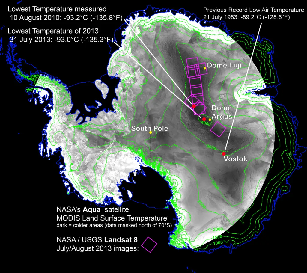
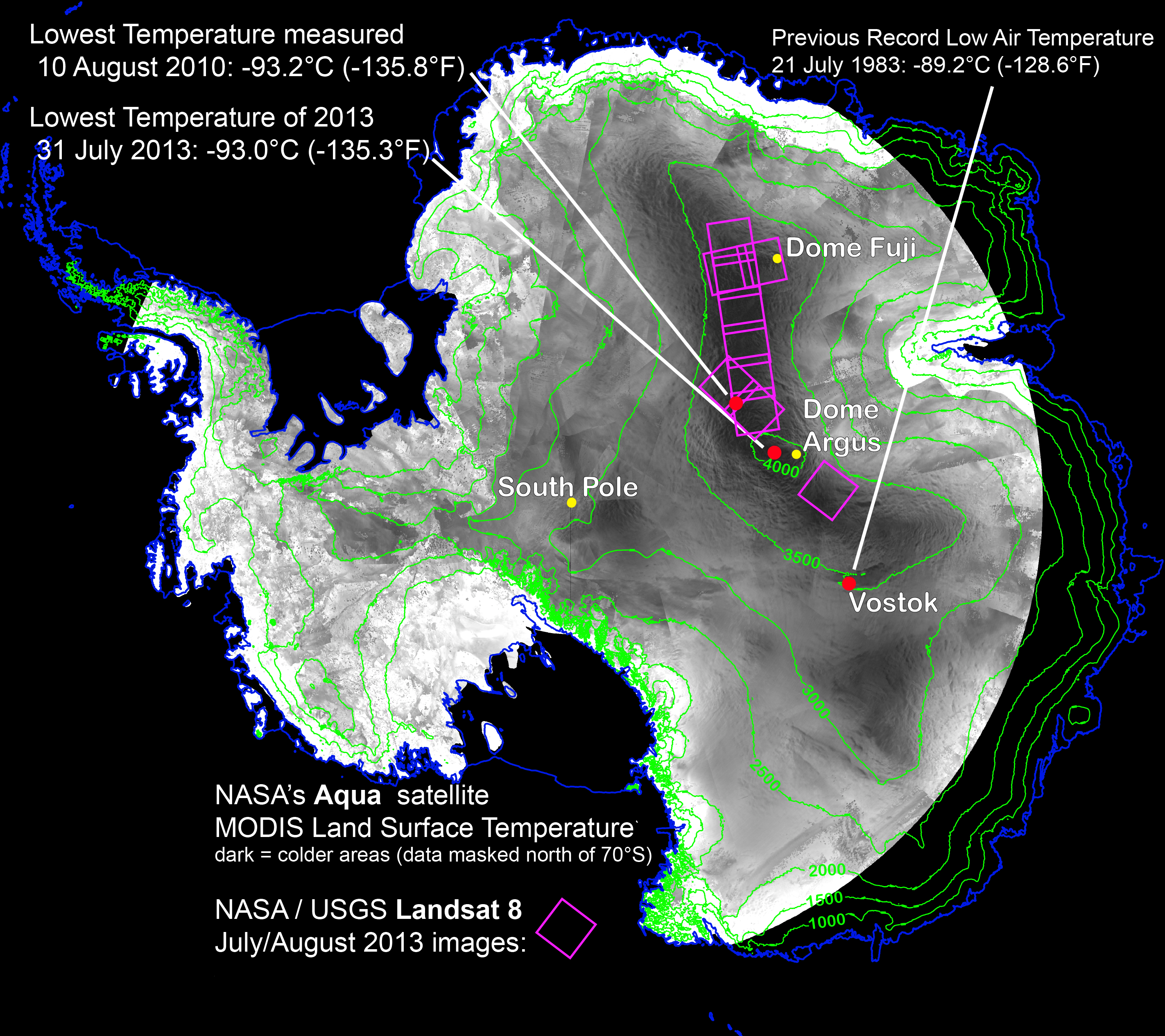
In search of the coolest place on Earth, scientists analysed land surface temperature products from different satellites of 32 years. Moderate Resolution Imaging Spectroradiometer (MODIS) aboard of NASA’s Terra and Aqua satellites as well as the Advanced Very High Resolution Radiometer (AVHRR) on several satellites of NASA are capable to record thermal radiation from Earth’s surface also in places lacking much heat. The analysis revealed that a valley-like area along a 1000km stretch between the two summits of the East Antarctic Plateau, Dome Argus and Dome Fuji, exhibits temperatures plummeting to record lows dozens of times. Against the suspicion that ridges are likely to be the coldest spots, the lowest temperature accumulates in less elevated areas, pockets, in between. The new record of -93.2°C was set on August 10, 2010.

With remote-sensing satellites, scientists have found the coldest places on Earth, just off a ridge in the East Antarctic Plateau. The coldest of the cold temperatures dropped to minus 135.8 F (minus 93.2 C) -- several degrees colder than the previous record. Image Credit: Ted Scambos, National Snow and Ice Data Center

The coldest places on Earth investigated by remote sensing means was located just off a ridge in the East Antarctic Plateau. The coldest of the cold temperatures dropped to minus minus 93.2 C — several degrees colder than the previous record. Image Credit: Ted Scambos, National Snow and Ice Data Center

 WHY ARE VALLEY SHAPED AREAS IN EAST ANTARCTIC COLDER THAN ELEVATION AREAS?

Low temperatures are fostered by clear sky conditions, when the ground radiates the heat into space and at the same time chills. If a clear sky persists the temperature around the snowy and icy surface becomes super-cold creating a dense layer of air that slides down the shallow slopes of East Antarctic domes, in order to accumulate in pocket areas and producing record low temperatures. The described effect is noticeable in all mountainous regions, where chilling air around the peaks floats downwards and is trapped in basin areas creating layers of cooler temperature. As a dweller from an Alpine country I know this effect very well.

With the higher resolution of the Thermal Infrared Sensor (TIRS) aboard LANDSAT 8, the scientists were able to pinpoint record-setting locations. The study is an example of showing the usefulness of Landsat 8 and the TIRS instrument. In my article on December 4, 2013, I reported about Antartic’s first high-resolution map relying on LANDSAT satellite imagery.  Landsat 8 has captured approximately 550 scenes per day of Earth’s land surface. USGS (US Geological Survey) processes, archives and distributes the images free of charge over the Internet.

Source: NASA Goddard Center, News


Did you like this post? Read more and subscribe to our monthly newsletter!

Read on
Search