Multiple Constellations and more integration options: Better for GNSS?

Of late there has been significant interest in GLONASS and GNSS (Global Navigation Satellite Systems). The former because of the explosion of a russian rocket carrying several GLONASS satellites, the latter due to increase in the number of constellations that help navigate and locate. The latest in the ever increasing list of such Navigation Satellite Systems being India’s Regional Navigation Satellite System IRNSS that promises to be the local equivalent of GPS in India.

Multiple Constellations and more integration options: Better for GNSS?

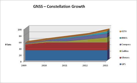
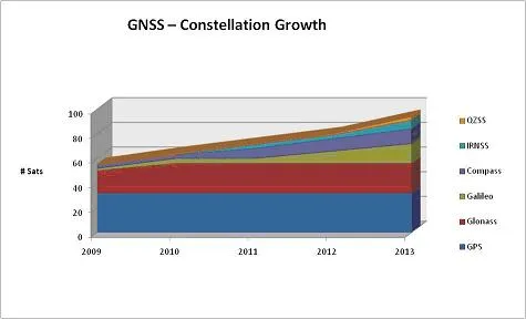
GNSS growth forecast. Image courtesy Government of Australia – Space department

Apart from all these new constellations, each day there are new technologies like Time and Inertial Measurement Unit (TIMU) from University of Michigan, GPStoo, etc that can be integrated along with the existing Satellite based positioning i.e. GNSS. These integrated positioning systems are capable of working even under jamming, help improve positioning accuracy and avoid total positioning blackout if GNSS satellite signals are unavailable for a short duration of time (like when we are driving inside a tunnel).

It has never been so good for GNSS! Does all this mean there will be better accuracy, integrity and availability ?

Well, yes but there are certain limitations. The diversity and redundancy provided by independent, compatible and (in some cases) interoperable GNSS systems brings a significant advantage in terms of availability and integrity in challenging urban environments and high multi-path areas where the best signals can be selected for positioning and the worst ones can be discarded and eliminated from the positioning algorithms. However there would be inherent limitations due to the fundamental design of GNSS and Integration systems. There is only so much we can do, beyond a point it’s just unwanted redundancy! The same is the case with Multiple constellations in GNSS.

Multiple Constellations and more integration options: Better for GNSS?

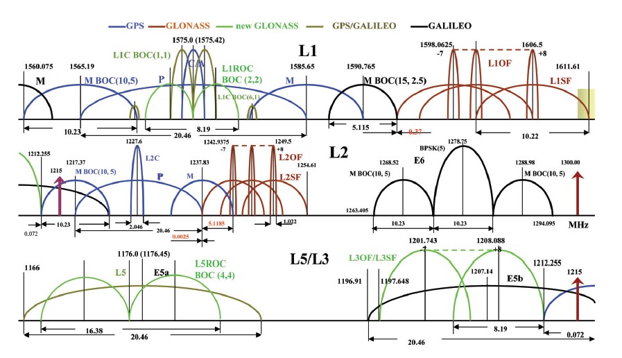
GNSS signal overlap

Let me explain with an example: Multiple constellations means better signal diversity and redundant measurements but there would be limitations caused by the orbital height of these satellites. In GNSS positioning, the general rule of thumb – height accuracy is 1.5 times worse than horizontal positioning accuracy. Wondering why? Simple, the geometry of satellites on the lat-long divide is much better than the almost equidistant satellite elevation of 22000 kilometers of GNSS satellites which results in better horizontal accuracy than height accuracy and the fact remains that this is not going to change much even with multiple constellations!

Multiple Constellations is definitely a good thing but beyond a point, it’s not going to help much. I couldn’t it have said it better than the author at InsideGNSS

” Well, almost certainly. But as with many things in life and technology, the devil’s in the details. And, as the varied characteristics and design specifications of new GNSSes and regional systems become clearer, it may not be too early to sort out those details” SOURCE: InsideGNSS

If you are intrigued and want to understand better, here’s the link to a wonderful article by Inside GNSS on this topic.


Did you like this post? Read more and subscribe to our monthly newsletter!

Say thanks for this article (0)
The community is supported by:
Become a sponsor
#
#Agriculture #Business #Construction #Data processing #Energy #Environmental Protection #ESG #Financial Services #Geospatial analytics #Geospatial for Good #Government #Health Care #Military #Natural Resources #Real Estate #Transportation
Making Sense of Satellite Imagery: How Can We Process Data at Scale?
Avatar for Barry Morisse
Barry Morisse 05.13.2024
AWESOME 2
#Agriculture #ESG #Featured #Financial Services #Geospatial for Good #People
Earth Observation in Banking and Finance: How Spatial Insights Drive Decision-Making and Support Communities – Meet UX Researcher, Cyhana Williams
Nikita Marwaha Kraetzig 11.28.2024
AWESOME 1
#Featured #Ground stations #Satellites
Ground Stations Explained: How Does Satellite Data Travel from Space to Earth?
Nikita Marwaha Kraetzig 02.29.2024
AWESOME 9
Next article

SBAS Interoperability Working Group: Setting up a common standard

The SBAS (Satellite Based Augmentation System) Interoperability Working Group consisting of more than 30 specialists overseeing the world’s five satellite navigation augmentation systems from United States of America, Russia, European Union, Japan and India gathered at Russia’s Svetloe Space observatory in late june this year, planning for a high-performance future with many more navigation satellites in orbit.

The Satellite Based Augmentation Systems basically complement the Global Navigation Satellite Systems by compensating for certain disadvantages of such Global systems in terms of accuracy, integrity, continuity and availability. SBAS helps improve positioning accuracy by sending real time corrections for Ionospheric errors. In a sense the SBAS works like a Real Time Kinematic (RTK) network by sending corrections to the user thereby helping improve position accuracy.

However, the current SBAS do not have any mechanism for interoperability i.e. USA’s WAAS has a different message format when compared to EU’s EGNOS. Interestingly all SBAS utilize GPS as their basic GNSS constellation for which they send corrections to the user on the ground (or to an aircraft).

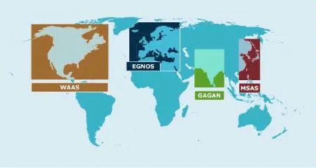
Current SBAS Constellations

Current SBAS Constellations

The working group is meeting twice an year with the main objective of ensuring that the various systems work together on a standard basis, so that an end user can seamlessly switch from using one system to another. In the current scenario, an aircraft that is flying over Europe can’t utilize GAGAN even if it able to track both – thanks to the different message formats that each SBAS uses but the SBAS Interoperability Working Group is hopeful that this be soon rectified.

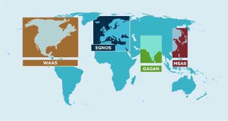
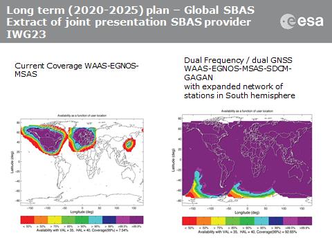
Planned SBAS Coverage. Image Courtesy: ESA

Planned SBAS Coverage. Image Courtesy: ESA

The extended coverage and interoperability will greatly help improve accuracy of positioning worldwide and maybe even help in cooperation between different Global Navigation Satellite Systems!


Did you like this post? Read more and subscribe to our monthly newsletter!

Read on
Search