#Space
NDVI Is Not Enough: What Are Vegetation Indices and How Are They Used in Precision Farming?
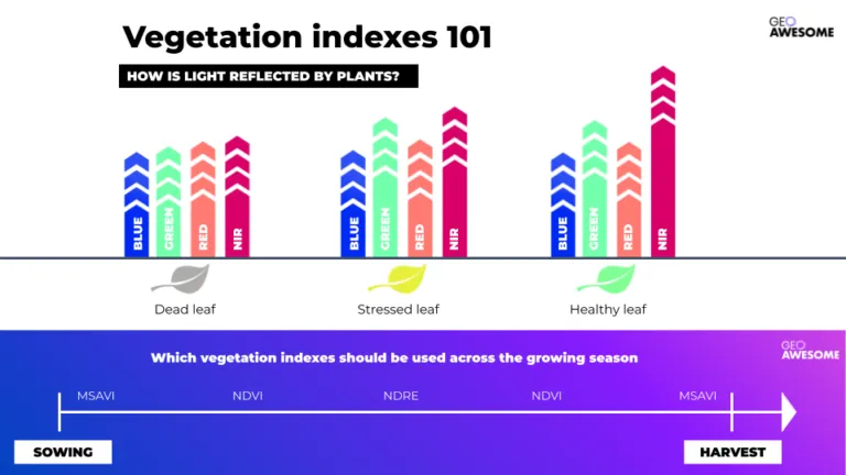
Vegetation indices in precision agriculture go far beyond NDVI. Discover how MSAVI, NDRE, CCCI, drones, SAR, and high-resolution satellite data support smarter irrigation, fertilization, and yield decisions — and why combining multiple indices is key to truly data-driven farming.

Vegetation indices in precision agriculture go far beyond NDVI. Discover how MSAVI, NDRE, CCCI, drones, SAR, and high-resolution satellite data support smarter irrigation, fertilization, and yield decisions — and why combining multiple indices is key to truly data-driven farming.
Seeing the Earth from the Stratosphere
High-Altitude Platform Stations (HAPS) operate in the stratosphere at 16–24 km, bridging the gap between drones and satellites. Discover how fixed-wing aircraft, airships, and balloons enable long-endurance connectivity and Earth Observation, and why this fast-growing market is set for takeoff.

High-Altitude Platform Stations (HAPS) operate in the stratosphere at 16–24 km, bridging the gap between drones and satellites. Discover how fixed-wing aircraft, airships, and balloons enable long-endurance connectivity and Earth Observation, and why this fast-growing market is set for takeoff.


Search