For decades, space was the playground of big organisations be it government agencies with bottomless budgets or massive aerospace corporations. Today, the space sector is much more dynamic and the most exciting breakthroughs aren’t just happening on launchpads; they’re happening on the laptops of entrepreneurs who see the Earth through a different lens. Space technology has evolved into the ultimate problem-solving toolkit, allowing us to tackle everything from climate resilience to urban logistics with surgical precision. If you’re an innovator ready to turn cosmic data into terrestrial value, there is no better “Mission Control” than the CASSINI Challenges.
Organized by the European Union Agency for the Space Programme (EUSPA), this annual competition has quickly cemented itself as the premier launchpad for European space entrepreneurs. It’s more than just a contest; it’s a opportunity bridge between EU Space data and real-world impact. With a massive prize pool and unparalleled access to a network of industry titans and fellow visionaries, the CASSINI Challenges are designed for those who don’t just want to watch the future happen—they want to build it.
What Are the CASSINI Challenges?
The CASSINI Challenges represent one of Europe’s most ambitious space entrepreneurship initiatives, designed to accelerate the development of innovative solutions that leverage EU Space Programme components. These include Galileo (which helps us navigate using satellite signals), Copernicus (which observes the Earth), GOVSATCOM (which ensures secure satellite communications), and SST (which tracks and observes space).
The competition is seeking entrepreneurs, start-ups, and SMEs that demonstrate how space technology addresses important business, social, or environmental challenges while also making Europe more independent and competitive in the global space industry.
The 2026 Competition: Space to Lift Europe
The 2026 edition focuses on the theme “Space to Lift Europe,” encouraging participants to present Minimum Viable Products (MVPs) that meet specific maturity requirements:
- Technology Readiness Level (TRL) ≥ 5: The technology must be validated in a relevant environment
- Commercial Readiness Level (CRL) ≥ 4: Evidence of early market validation and foundational commercial infrastructure
This dual requirement ensures that winning solutions aren’t just innovative concepts but market-ready products with genuine commercial potential.
Who Can Participate?
The competition is open to economic operators (both natural and legal persons) that are based in EU Member States. To submit, you must be at least 18 years old. Participants can apply individually or as teams.
For solutions that use Galileo or satellite navigation, economic operators in Norway and Switzerland can also participate. Solutions that focus on Copernicus or Earth observation can also include participants from Iceland, Norway, and the UK. Also, companies from countries involved in Horizon Europe can take part if their solutions help make the European space industry more competitive.
The Prize: €100,000 for Each Winner
The prizes are significant: twelve winners will receive €100,000 each to help their businesses grow and bring their solutions to market. This competition has a total prize pool of €1.2 million. That makes it one of Europe’s most generous competitions for space entrepreneurs.
Winners get exposure beyond money at the CASSINI Entrepreneurship Days. There, they can present their solutions to investors, accelerators, corporations, and the broader European space start-up community.
The Evaluation Process
Applications undergo a rigorous two-stage evaluation by an appointed EUSPA Evaluation Committee:
- Initial Assessment: All applications are evaluated against four award criteria (maximum 20 points total)
- Shortlisting: Up to 50 teams are selected to present their solutions online
- Final Evaluation: The committee re-evaluates solutions during presentations and ranks applications
- Winner Selection: The top twelve applications are proposed for award, subject to eligibility verification
The evaluation criteria focus on:
- Relevance to the EU Space Programme (max 4 points)
- Commercial potential and market readiness (max 6 points)
- Innovation and feasibility (max 6 points)
- Execution capability (max 4 points)
Applications must achieve both individual minimum thresholds for each criterion and an overall minimum of 12 points out of 20.
Past Success Stories
Since its inception, CASSINI Challenges has supported 149 winners across multiple editions, each representing breakthrough innovations in space technology applications.
2023 Winners included five groundbreaking start-ups, each receiving €100,000:
- Murmuration: Monitoring tourism’s environmental impact using satellite data
- j-Snow: Providing near real-time snow monitoring with high-resolution satellite data
- Ajuma: Employing satellite data for UV monitoring and skin cancer prevention
- ClearkSky vision: Delivering daily cloud-free Sentinel-2 images using deep learning
- Onocoy: Creating a community-powered network of GNSS reference stations for ultra-accurate positioning
2024 Winners demonstrated the program’s evolution across three tracks (Idea, Prototype, and Product), showcasing solutions ranging from space debris removal to biodiversity monitoring, agricultural optimization, and advanced satellite communication systems.
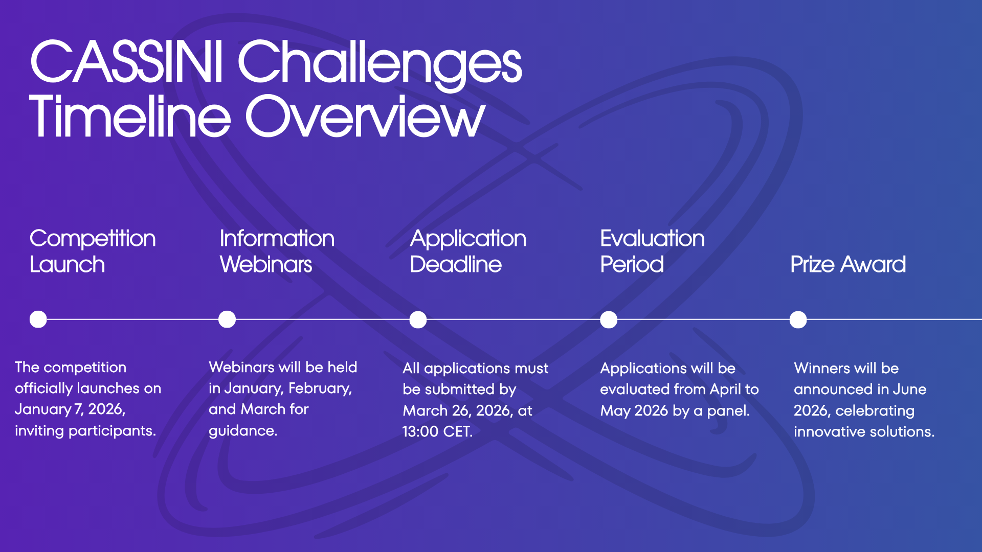
Information Webinars
To help potential applicants understand the competition, EUSPA hosts information webinars covering:
- MVP technical and commercial requirements
- The competition theme and evaluation criteria
- Application walkthrough and submission tips
- Timeline and key milestones
These sessions provide crucial guidance and allow participants to ask questions directly to the organizing team.
How to Apply
Applications must be submitted through the dedicated CASSINI Challenges platform and include:
- Completed application form
- 3-minute video presenting the MVP and team
- Declaration of ownership
- Declaration of honour
- Identification forms with supporting documents
All materials must demonstrate compliance with minimum TRL and CRL requirements and clearly articulate how the solution leverages EU Space data to address significant challenges.
The CASSINI Challenges represent an extraordinary opportunity for European space entrepreneurs to transform innovative ideas into commercial realities. With substantial prizes, expert evaluation, and access to Europe’s space ecosystem, the competition has established itself as the premier platform for launching space-based businesses.
For more information and to apply, visit www.euspa.europa.eu/cassinichallenges.
Did you like this post? Read more and subscribe to our monthly newsletter!


#Events

Next article

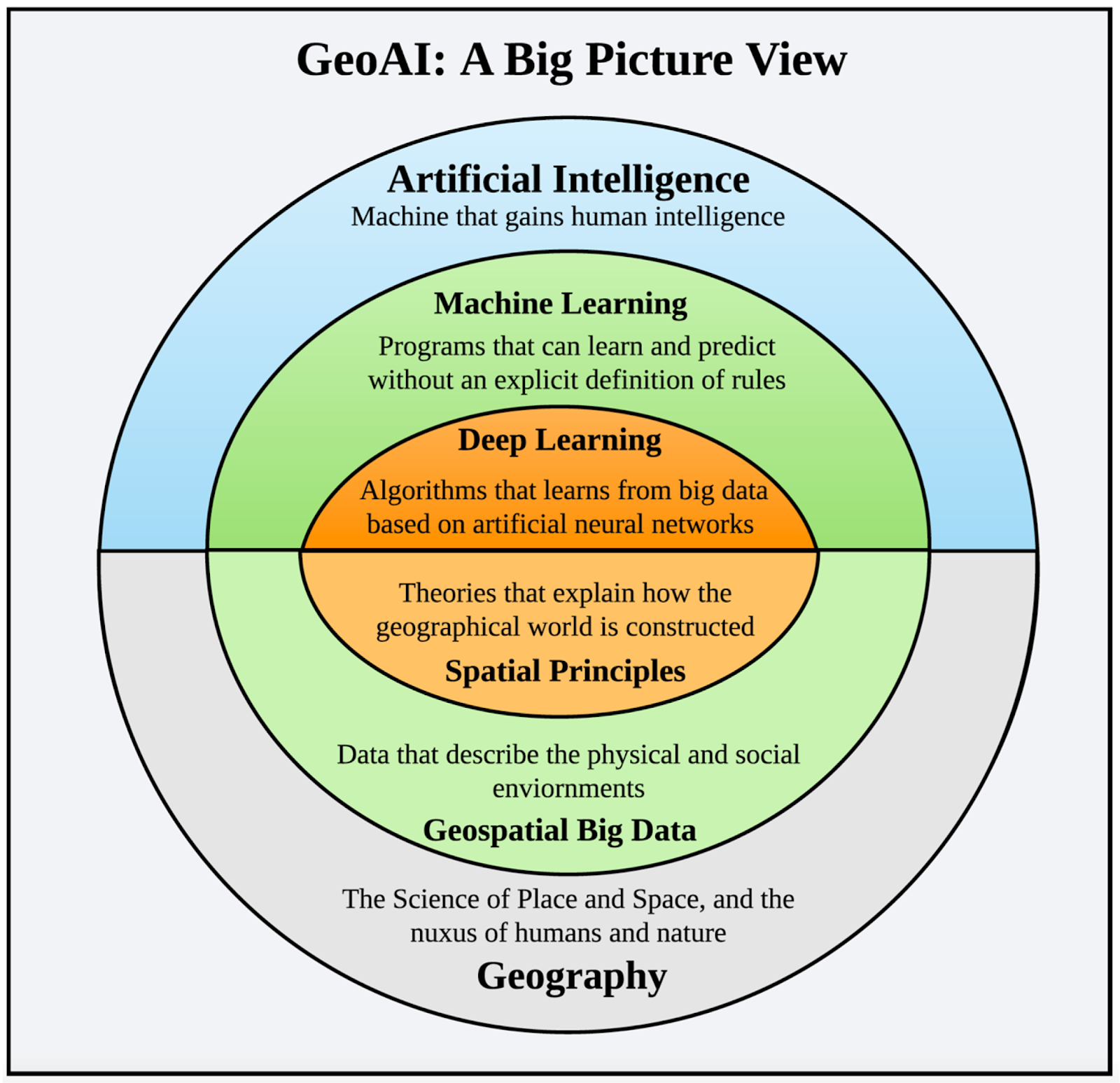
Modern geospatial AI has become remarkably good at prediction. Given enough historical data, models can forecast flood extents, traffic congestion, or infrastructure stress with impressive accuracy. Recent advances, such as Prediction-to-Map flood forecasting, show that complex spatial predictions can now be produced far faster than traditional numerical models.
Yet accuracy alone often fails at the moment decisions matter. When conditions change, planners and responders ask questions that predictive models struggle to answer. Why did flooding concentrate here instead of there? If we block this road or close that floodgate, what breaks downstream? Is a certain outcome even physically possible given the constraints of the system?
This gap has become increasingly visible during recent extreme events, where cascading infrastructure failures revealed that many breakdowns were not caused by missing predictions, but by poor understanding of dependencies and constraints. As several analyses of modern infrastructure risk point out, models trained on past patterns often struggle when the rules of the system are stressed or altered.
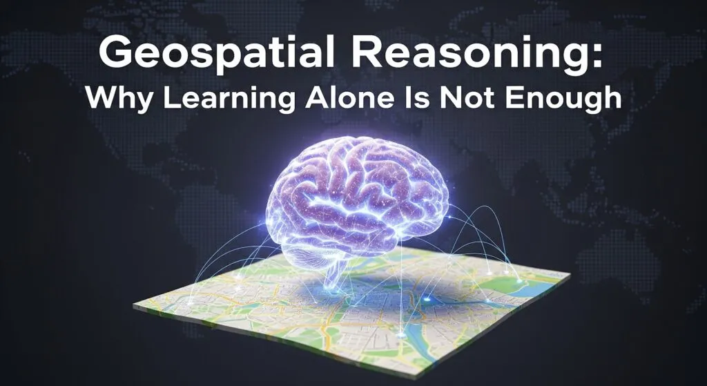
This article argues that spatial systems require more than learning patterns from data. They require geospatial reasoning: the ability to respect physical constraints, understand connectivity, and reason about “what if” scenarios. It is written for geospatial practitioners, data scientists, and planners who already use GeoAI, but want to understand where learning ends, where reasoning begins, and why combining both is essential for real-world decision support.
What Geospatial Learning Does Well?
Modern geospatial learning is strong at large-scale pattern recognition. By processing vast amounts of satellite imagery and sensor data, GeoAI systems can extract building footprints, classify land cover, detect vegetation stress, and monitor change at a global scale.
A major advance has been the rise of geospatial foundation models, trained on diverse Earth observation data to generalize across tasks and regions. These models can segment complex scenes, describe imagery, and adapt to new problems with minimal additional training, even in data-sparse settings.
Learning also excels at creating spatial embeddings, compact representations that allow places to be compared, clustered, or searched for similarity. Work on satellite embeddings and large-scale spatial representations shows how embeddings make it possible to compare places, search for similarity, detect anomalies, and transfer insights across cities, ecosystems, and countries
Together, these capabilities have lowered the cost of turning raw geospatial data into useful signals. Learning gives us powerful eyes on the planet. The question is where this approach begins to break down.
Source: MDPI
Where Learning Falls Short?
Learning can estimate what is likely. Reasoning determines what is possible.
As spatial systems grow more complex, the gap between recognizing patterns and understanding mechanisms becomes clear. A core limitation of geospatial learning is its reliance on correlation without awareness of physical constraints. Models may associate flooding with certain visual patterns in imagery, yet fail when terrain, vegetation, or flow dynamics differ from the training data, a weakness widely discussed in analyses of the limits of AI in water resource management.
This issue appears clearly in flood modeling. Evaluations of AI-enhanced versions of the National Water Model show that while learning can improve accuracy, models that ignore dominant physical processes systematically underpredict flooding when conditions shift.
Learning also struggles with topology and connectivity. Geography is governed by networks, yet many models treat spatial data as independent pixels. This leads to failures when disruptions propagate through systems, a problem documented in studies of spatial reasoning errors in AI and benchmarks on LLM spatial reasoning.
Finally, purely data-driven models lack counterfactual reasoning. They extrapolate from the past but struggle to assess interventions that change the system itself. Research on causal machine learning for flood damage estimation shows why prediction alone is insufficient in rapidly changing environments.
Learning can estimate what is likely. Reasoning determines what is possible.
What Geospatial Reasoning Actually Means?
If geospatial learning provides the eyes of a system, geospatial reasoning is the brain. It takes detected patterns and evaluates them against rules about how the physical world works. Instead of stopping at “there is a road here,” reasoning asks whether that road is the only access to a hospital, or what happens if it is blocked.
At its core, geospatial reasoning is a shift from statistical guessing to structural thinking.
First, it respects rules and constraints. Certain constraints are non-negotiable: water flows downhill, vehicles cannot pass through solid barriers, and land uses cannot overlap arbitrarily. Many failures in AI systems stem from violating these basic physical truths, a limitation highlighted in analyses of why AI struggles with real-world physical tasks.
Second, reasoning focuses on relationships rather than isolated features. Geographic entities exist within hierarchies and systems. A drain belongs to a pipe network, which sits inside a watershed. This relational view underpins the concept of geospatial knowledge graphs.
Third, geospatial reasoning propagates effects through space and time. A failure rarely stays local. If a substation goes down, reasoning traces which neighborhoods or services depend on that connection, reflecting the logic of flow and dependency that defines spatial systems.
Finally, reasoning enables “what if” and “what must be true” questions. Instead of predicting what usually happens, it evaluates interventions and constraints. This shift toward scenario-based reasoning is increasingly emphasized in work on geospatial reasoning with foundation models.
Learning helps AI recognize the pieces on the board. Geospatial reasoning gives it the rulebook to understand the consequences of each move.
Source: Google Research
Why Geography Demands Reasoning?
Geography is fundamentally different from most data domains. While many datasets treat records as independent, spatial systems are defined by proximity, flow, and dependency. This makes purely predictive models fragile when applied across regions or scales, a limitation highlighted in work on spatial generalization in machine learning.
This difference comes from a few core spatial properties. Geographic systems are shaped by two factors: connectivity, as roads, rivers, and power lines form networks whose effects propagate, and directionality and flow, as physical rules like gravity constrain what is possible. Ignoring these constraints is a common source of error in hydraulic and infrastructure modeling, as shown in examples of common mistakes in hydraulic models. Geography also exhibits spatial dependence, where the state of a place is influenced by its surroundings, a foundational concept in spatial topology and relationships.
Because of these properties, geographic systems behave as systems of systems. Without explicit reasoning about structure, constraints, and relationships, prediction alone is not enough.
The Role of Graphs and Data Cubes
To bring geospatial reasoning into practice, two data structures matter most: graphs and spatial data cubes. Graphs encode relationships explicitly, treating buildings, roads, pipes, and substations as connected entities rather than isolated features, which allows systems to trace dependencies and understand how effects propagate through networks. Spatial data cubes add time to this picture by stacking maps across days, months, or years, preserving how places evolve instead of freezing them in a single snapshot. Together, these structures align digital representations with how the physical world actually works, enabling reasoning about connectivity, change, and consequence rather than relying on opaque predictions.
Where Geospatial Reasoning Matters Today?
Geospatial reasoning is already changing how high-stakes decisions are made, especially in areas where static maps are no longer sufficient.
In the insurance industry, reasoning is replacing one-size-fits-all hazard zones with contextual risk assessment. Instead of pricing risk solely on whether a property falls inside a flood or wildfire boundary, insurers increasingly use geospatial data for insurance to account for proximity, elevation, directionality, and mitigation. This allows underwriting to reflect local conditions, such as drainage improvements or reduced exposure to wind-driven fire paths, a shift already reshaping pricing and portfolio management, as described in how geospatial analytics is changing insurance.
Geospatial reasoning is also central to climate adaptation planning. Rather than planning for average conditions, cities increasingly plan for threshold scenarios, using adaptation playbooks to link physical changes like sea-level rise or extreme heat to concrete actions. This approach, reflected in climate adaptation playbooks and broader assessments of adaptation costs and strategies, enables proactive rather than reactive decisions.
In these domains, geospatial reasoning does more than refine predictions. It connects spatial data directly to action.
Source: Google Research
From Predictive Maps to Decision Support
Geospatial AI is shifting from producing predictions to supporting decisions. For years, the goal was to answer “what is likely?”, resulting in maps that forecast risk or change. Today, decision-makers increasingly need systems that help answer a different question: “What should we do?”
This is where geospatial reasoning sits on top of learning. Learning extracts patterns from vast datasets. Reasoning evaluates those patterns against constraints, dependencies, and consequences, turning predictions into guidance that can actually be acted upon. The emphasis moves away from interpreting probability surfaces and toward evaluating options, trade-offs, and outcomes.
Looking ahead, the future of GeoAI is not about replacing learning, but grounding it. Learning will remain the eyes of the system, detecting patterns at scale. What comes next is grounded intelligence: models that combine data-driven learning with physical rules, topology, and causal structure, allowing systems to reason about what is possible, not just what is likely.
As these systems mature, geospatial reasoning will also become more accessible. Natural-language interfaces and agentic GIS tools are lowering the barrier between spatial expertise and action, enabling more people to ask meaningful “what if” questions and receive transparent, explainable answers.
Learning gives us vision. Reasoning gives us judgment. Together, they are what will make GeoAI truly useful in the real world.
Further Resources
- https://www.youtube.com/watch?v=g9F-_tCakL8&t=1s
- https://www.youtube.com/watch?v=ZyH3-7pBBiQ&t=1s
- https://medium.com/@guneetmutreja/beyond-pixels-a-new-era-of-geospatial-reasoning-with-alphaearths-embedding-calculus-6dcf073db057
- https://arxiv.org/abs/2505.17136
Did you like this post? Read more and subscribe to our monthly newsletter!

