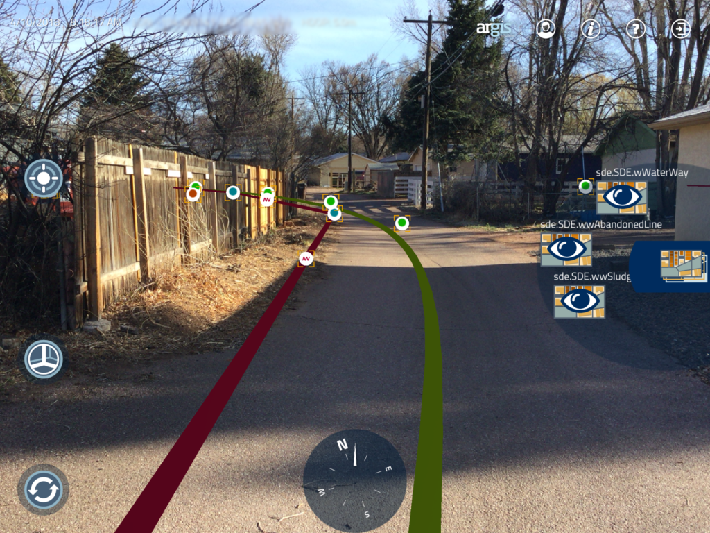
The world is not flat, so why should our maps be in 2D? When you think 3D maps, Augmented reality comes to mind. Augmented reality and maps have been in the news recently with Google announcing AR will be coming to Street view and Mapbox (and Google) announcing SDKs for AR and Location-based gaming. If you are wondering, “Sure, this is the cool side of AR and Maps, what about enterprise use cases?”, that is where Argis comes in the picture. Argis integrates ArcGIS with Augmented Reality. We spoke to Catherine Hoemke at Argis to learn more about their business and their vision. Here’s what she had to say – read on!
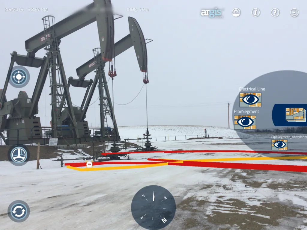
We help field crews overcome the limitations of locating and managing assets with 2D mapping technology. The Argis Lens, brings GIS data into the three-dimensional world they work in—creating a seamless user experience. Users can locate assets quicker, see 3D relationships they couldn’t see before and benefit from an all-around increase in productivity.
Q: When you founded Argis back in 2016, Augmented reality was very much in the “Innovation Trigger” phase (Hype cycle). It’s easy to wish to start a company in AR when there is a big hype about the technology but what motivated you to start your company specifically to use GIS and AR? How did you get to that point?
Answer: The initial core development team who created the Argis Framework and the Argis Lens has over 20 years’ experience working in the GIS industry combined. Because of this deep understanding of how ArcGIS works, the team was able to do the hard work of creating 3D objects and then anchoring them with geodata in the real world. It seemed a natural extension of where geospatial data should be going.
Q: Your main focus at Argis to help field crews to overcome the limitations of location and managing assets. Could you tell us more about that? How does AR come into the picture?
Answer: We live in a 3D world. Our maps should reflect that reality. No matter how detailed GIS data is, it is still fundamentally a step removed from the user’s direct perception of the real world. By placing mapping information as an overlay which is geographically anchored to visible elements, AR creates an intuitive interpretation which users instantly “get.” It becomes a more efficient field application.
Q: It’s been little over 2 years since you started the company, where do you think AR is in the Hype Cycle? Are customers already ready to pay for it or is it still more a beta phase for most customers?
Answer: We have many forward-thinking clients who can see the intrinsic value of adding AR to their workflow. These are mostly in the 811 locate field and public works departments in municipalities and towns. Though AR is not a household name as of yet, I believe we are on the Peak of Inflated Expectations. The public has been told this particular use case story by the media (AR will give you X-RAY vision!) and we are now in the process of sharing what AR really can do for you: show users 3D relationships between GIS elements in the context of the job site and that intrinsic value to the user.
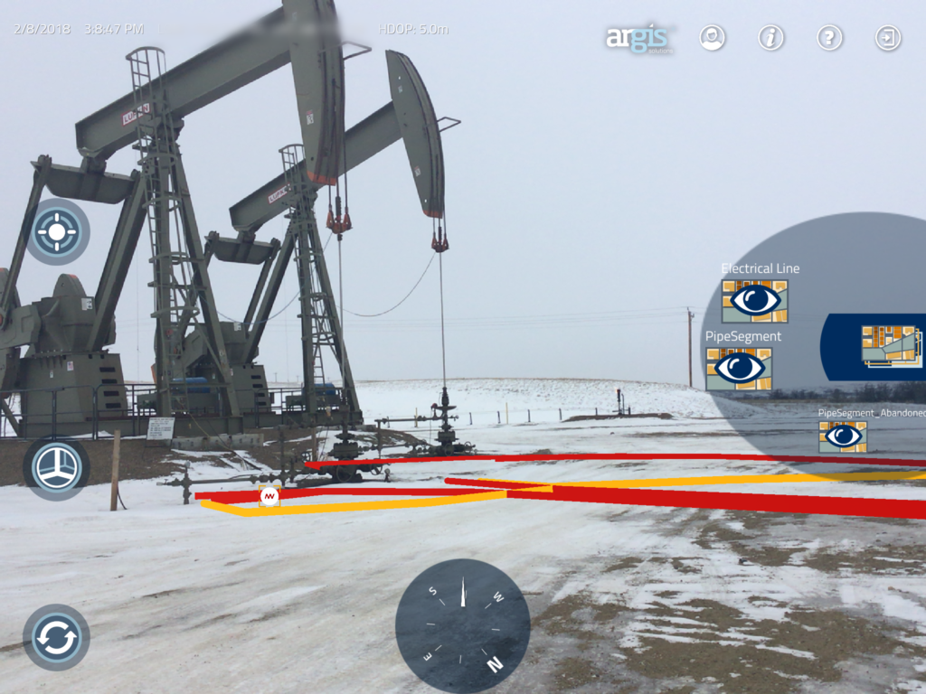
- Courtesy of Whiting Petroleum, Watford City, ND
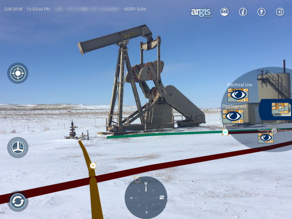
- Courtesy of Whiting Petroleum, Watford City, ND
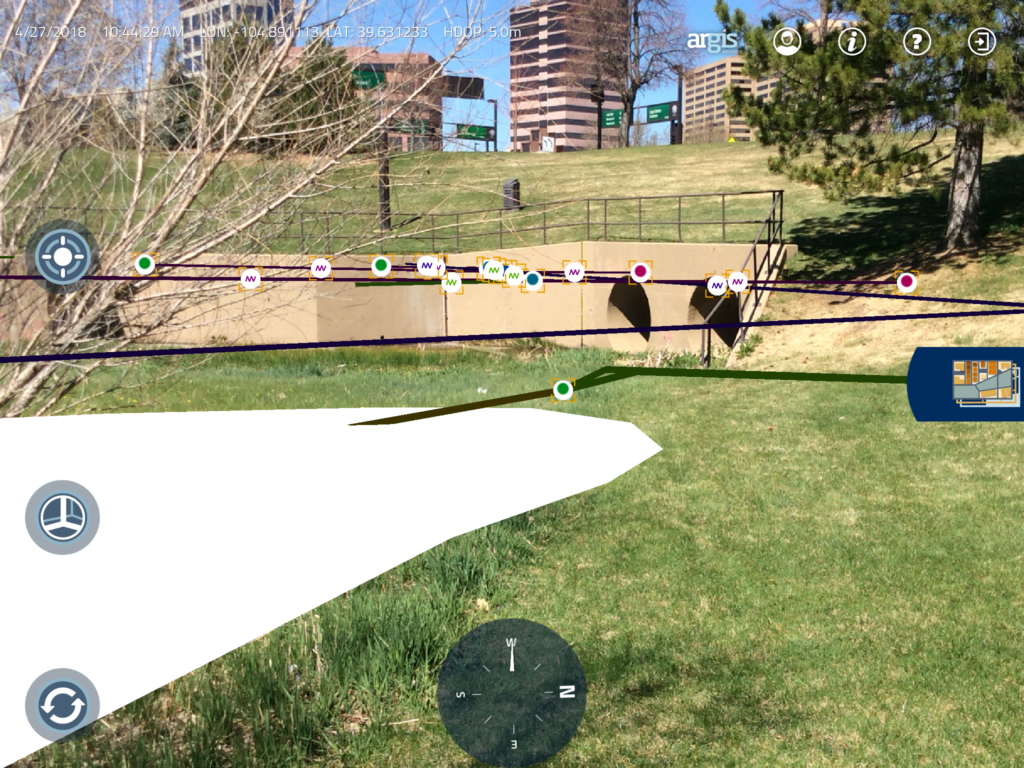
- Denver, CO – stormwater public source
- Colorado Springs
Q: When using AR and GIS on the field, is positioning accuracy a challenge/pain point for customers? How do you give customers the confidence that they are looking at the right position in the field?
Answer: With a quality external GPS, such as an Asteri X series or Trimble R1/R2, accuracy is quite painless with the Argis Lens. The biggest problem users run into is when the inherent accuracy of their data is lacking. A lot of data out there was not created with 3D representation in mind. Most of it was originally created to be used with aerial photos.
With that being said, the Argis Lens can visualize most ArcGIS data, including colours and simple symbology. Though z-index data can help clarify the location of assets underground in AR, it is not necessary to start seeing efficiency and productivity increase on field inspections.
Q: Could you tell us more the tech stack at Argis? What technologies do you use? What programming languages do you use?
Answer: The Argis Lens is an iOS app that uses a combination of Unity as an AR visualization engine coupled with our proprietary software that creates volume, depth and location on the fly for ArcGIS feature services.
The most common method of connecting ArcGIS to our product is through a REST API call to ArcGIS Online. We can also connect to ArcGIS Enterprise. We mean it when we say “if you have ArcGIS data, you have AR data…you are just not using it yet!”
Q: Argis Lens – your flagship product is currently available on mobile devices. Can we expect to see the product on more platforms? Hololens perhaps?
Answer: Market demand is the biggest limiting factor we have found for the adoption of the more high tech wearables such as hololens. The markets that have field operators in them are just now adopting iPads and tablets. These users are often very concerned with Occupational Safety and Health Standards and safety issues are a high priority. They are also slow to adopt new technology. We think wearables will have a place in the market share in the future. When our clients are ready to make the jump to an expensive wearable device, we will be ready to meet them there.
Q: As a startup founder, I am sure that there are many things that you must have learnt along the way. What was the most interesting feedback that you received so far?
Answer: It always amazing how many good ideas an audience will come up with once they understand the concept of accurate GIS in Augmented Reality. Field technicians are blown away by the concept of showing their data on a job site, in a way that their entire crew can understand instantly. The biggest struggle has been narrowing the focus and finding where AR is invaluable to an industry, such as situational awareness, training or documenting assets.
Q: More often than not it takes a while to find a business model that works for your clients. Have you cracked that code already?
Answer: We believe we have found how AR can really create value for users as a conduit for connecting the office and the field to their third-party contractors. We will be saying more on this at the Esri UC18, at the SIG on AR/VR.
Q: You are based in Denver, USA, how’s the startup scene there? Is it easy to hire people and get investments? Are there any accelerator programs/venture capitals that focus on geo companies?
Answer: We have had a minimum of venture capital investment, so we are not up on the VC scene. As for hiring, we have such specific skill sets that we tend to approach potential hires directly. With that said, we have had a lot of help from the Esri Emerging Partners and Startups group in our first few years of business.
Q: Okay, this is a tricky one – on a scale of 1 to 10 (10 being the highest), how geoawesome do you feel today? 😉
Answer: Ten of course!
Q: Any closing remarks for anyone looking to start their own geo startup?
Answer: Market research is invaluable for startups in the GIS as well as being very familiar with Esri. We highly recommend Crossing the Chasm (Moore) as a resource.
The Next Geo is supported by Geovation:
 Location is everywhere, and our mission is to expand its use in the UK’s innovation community. So we’re here to help you along your journey to success. Get on board and let’s start with your idea…
Learn more about Geovation and how they can help turn your idea into reality at geovation.uk
About The Next Geo
The Next Geo is all about discovering the people and companies that are changing the geospatial industry – unearthing their stories, discovering their products, understanding their business models and celebrating their success! You can read more about the series and the vision behind it here.
We know it takes a village, and so we are thrilled to have your feedback, suggestions, and any leads you think should be featured on The Next Geo! Share with us, and we’ll share it with the world! You can reach us at info@geoawesomeness.com or via social media ?


