
AI Super-Resolution in Satellite Imagery: Enhancing Clarity Beyond Native Resolution

The satellite imagery landscape has changed dramatically in recent years. A sharp rise in data quality and accessibility has made satellite images indispensable across sectors — from agriculture to urban planning. Yet even with today’s highest-resolution imagery, analysts often struggle with interpretation, wishing they had just a few more pixels to work with.
AI is now stepping in with a powerful solution: advanced super-resolution (SR) models that elevate satellite imagery to a new level of clarity.
While SR does not truly increase the native resolution of the original data, it can substantially enhance visual detail, effectively generating High Definition (HD) imagery. In commercial applications, SR has been used to sharpen images from 30 cm to 15 cm resolution or from 50 cm to 30 cm. Some approaches go even further, enhancing lower-resolution open data — for example, improving European Sentinel-2 imagery from 10 m to an apparent 2.5 m resolution. Importantly, these enhancements can be applied across all spectral bands.

Image from Maxar
Despite its name, super-resolution’s improvements are primarily aesthetic. By generating extra pixels, SR refines the edges of objects and artificially reconstructs details, enhancing the overall visual clarity and readability of the image. However, SR does not unveil any hidden data that wasn’t initially captured. For instance, if an object isn’t present in the original data, SR will not reveal it in the enhanced image. Consequently, while an SR image may contain more pixels than its low-resolution counterpart, the Ground Sampling Distance (GSD) remains unchanged.
Despite these limitations, the advent of super-resolution technology is unlocking numerous new possibilities and practical applications across a wide array of industries. As the technology continues to evolve, its potential to revolutionize satellite imagery and its applications will undoubtedly reach even greater heights.
How does it work, and how is it implemented in satellite imagery?
The concept of super-resolution is not unique to satellite imagery. It is now a fairly widely available machine-learning task used to upscale and improve the details within an image; creating a high resolution output from a low resolution input, usually for aesthetic purposes. By applying an algorithm to the low-resolution image, absent details are filled in, increasing the resolution while maintaining or improving visual quality. Of course, the higher the original input resolution, the better the result in the SR image. SR is particularly good at creating precise edges and enhancing long linear features.
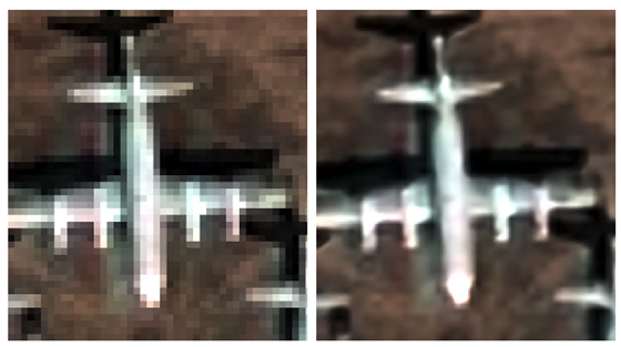
Image from UP42
AI super-resolution models use deep learning techniques, whereby algorithms are trained on large datasets containing pairs of high-resolution and corresponding low-resolution images. This process teaches the model to recognise which data is missing from an image, and therefore how to reconstruct it.
The most common architecture for these AI models is a type of neural network called a convolutional neural network (CNN), which is specifically designed for processing grid-like data—e.g. digital images. Using this method, images are processed through multiple filters, including convolutional and pooling layers, which are able to extract high-level features and textures, thereby enabling the model to recognize complex patterns.
The model is also trained to minimize the difference between the SR output and the true high-resolution image. This is done using a loss function (such as mean squared error or perceptual loss) and encourages the model to produce reconstructed images which are both aesthetically pleasing and accurate.
Additional challenges arise when applying SR to satellite data. Traditional super-resolution algorithms have been developed on RGB images, but to work with satellite imagery they need to be trained on multispectral—or hyperspectral—data, which can have dozens of bands. Atmospheric conditions present additional hurdles to overcome and may be misinterpreted by an AI model.
Notable super-resolution approaches and products
Despite the challenges, there are already several notable products on the market that leverage SR technology, each of which employs cutting-edge machine learning techniques to provide analysts with enhanced detail and readability.
Maxar’s HD technology has also achieved significant success, producing 15cm SR images that consistently rate 6–7 on the National Imagery Interpretability Scale (NIIS). (The NIIS is a subjective scale used by image analysts to rate the quality of aerial imagery from 0–9, where, for example, basic land use is intelligible at 1 and a car licence plate can be read at 8.)
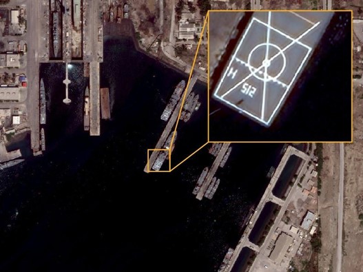
Image from Maxar
Another example is coming from South Korean company Nara Space which developed a super resolution algorithm that improves the readability of Pléiades Neo images from 30 cm to 10 cm. Airbus itself offers Pléiades Neo HD15 product with 15cm enhanced resolution.
Benefits and applications of super-resolution models in satellite imagery
SR models in satellite imagery offer opportunities across a multitude of applications, including mapping, monitoring, feature identification and analytics. By enhancing the visual experience and reducing pixelation, these models provide analysts with actionable information, allowing them to discern smaller features on the ground, and thereby contribute to better decision-making.
In urban planning, SR enables more precise identification of features, and reduces error rates dramatically in identifying smaller objects like lampposts, solar panels, road signs and vehicles. Enhanced images of infrastructure conditions may prove advantageous for asset monitoring and disaster management. SR models not only help with counting features, but can also enhance the textural information of vegetation and tree canopies, which has applications for agriculture and climate monitoring.
It’s also worth mentioning that SR has benefits for both new and archive imagery. For a start, it can help to increase the global supply of 30cm imagery by improving low-resolution archive data to match newly-collected 30cm native data. Tasking the highest-resolution satellites, meanwhile, is often prohibitively expensive, and SR models can provide a cost-effective alternative for a wide range of applications. In fact, the readability of satellite data when enhanced to 15cm becomes very close to 10cm aerial data. In some use cases, SR satellite imagery data could replace aerial data—at a fraction of the cost.
One particularly significant advantage of SR models is their ability to improve the accuracy of other AI models applied to satellite data. For example, early tests by Maxar showed that machine-learning models detecting cars had their accuracy improved by 15-40% when working with images enhanced by SR. In some cases, SR models even have improved interpretability over native 30cm data—particularly with regard to linear features and reconstructing markings on the ground or on vehicles.
Super-resolution: overcoming challenges to provide more reliable geospatial data
While super-resolution models offer a range of advantages, implementing them in satellite imagery is not without challenges. Aside from the primary concern of the model’s accuracy, other technical limitations can also pose significant challenges, as applying a SR machine learning model to satellite data can require a huge amount of processing power and data storage. Ethical and legal considerations, including privacy concerns and data usage restrictions, must also be addressed, while integrating super-resolution models with existing workflows and systems can prove complex and time-consuming. All of these challenges could potentially impede the adoption of SR in certain applications; however, with the major satellite companies like Maxar and Airbus all striving to overcome them, super-resolution satellite imagery is becoming a reality.
Super-resolution machine learning models offer an innovative solution to enhance satellite imagery readability for both human analysts and AIs, providing higher quality data for various applications. Their potential benefits in terms of improved decision-making and AI performance make them a hugely valuable addition to the analyst’s toolbox—and potentially a cost-effective alternative to native 30cm, or even 10cm aerial data, for many customers. As technology continues to advance, we can expect further improvements in super-resolution techniques and their applications in satellite imagery, paving the way for even more reliable geospatial data.
Did you like this post? Follow us on our social media channels!
Read more and subscribe to our monthly newsletter!
#Deep Tech

Next article
Weather shapes nearly every dimension of our lives. Reliable forecasts are not just helpful for planning our daily routines—they are mission-critical for sectors such as aviation, logistics, agriculture, and emergency response. Today, weather updates reach us instantly through clean icons on smartphone apps and widgets. Yet this simplicity hides the complex chain of data collection, modeling, and distribution that makes modern forecasting possible.
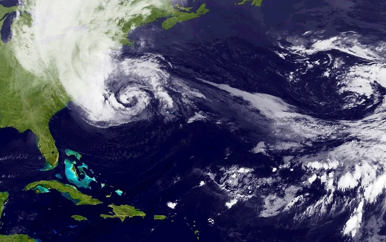
Over the past decades, satellites have transformed meteorology by enabling continuous, global observation of the atmosphere. This space-based perspective has significantly improved the accuracy of forecasts and, equally important, strengthened our ability to detect and warn against hazardous weather in time.
The science of weather forecasting
The current trend of representing weather through static icons on a smartphone screen does a lot to disguise the complexity of these dynamically changing systems. Weather is driven by thermodynamics: temperature differences between the poles and tropics, combined with the rotation of the Earth, influence the flow of air and water vapor across differentially heated parts of the planet’s surface. This fluid flow is also affected by factors such as oceans, land masses, and mountains. Weather forecasting relies on numerical weather prediction (NWP) models, which are mathematical models that simulate this fluid behavior.
‘Deterministic forecasting,’ which gives a single forecast outcome, is fraught with challenges, both due to chaos theory and the limitations of NWP models, and can only be relied on up to a few days in advance. Meteorologists, therefore, often use ‘ensemble forecasting’: By simulating different conditions, a range of possible outcomes can be predicted, together with their probability, making a forecast fairly reliable up to about two weeks—and despite long-running jokes about their accuracy (or lack thereof), weather forecasts have become incredibly precise over time.
However, none of this is possible without accurate data to input into the models. Measurements taken include atmospheric factors like precipitation, precipitable water (the total amount of potential precipitation in a column of the atmosphere), and wind direction and speed, but also ground-level factors, like sea surface temperature and other oceanic properties. This data comes from various sources, including weather balloons, ground stations—and, increasingly, satellites.
Satellite tools for weather forecast
Today, there are approximately 200 meteorological satellites in orbit, and the vast majority of them can be classified into two types. The first are polar-orbiting satellites, which travel around the Earth at low altitudes, from pole to pole, monitoring the entire planet as it rotates, over a period of 10 days to 1 month. Geostationary satellites, meanwhile, orbit at a high altitude over the equator, moving at the same speed as Earth’s rotation, thereby continuously monitoring a specific section of the planet. Both types play essential roles in weather forecasting.
Weather satellites are equipped with various instruments, including sensors for temperature and humidity, cameras for capturing images, and tools for measuring other atmospheric conditions like wind speed and precipitation. Generally, they are designed to be multi-functional, and carry a combination of different sensors to provide comprehensive observations. Some, however, may focus on a specific variable. For instance, the Global Precipitation Measurement (GPM) mission and Tropical Rainfall Measuring Mission (TRMM) both focus on precipitation data.
Some of the sensor types used by weather satellites
|
Advantages of satellites in monitoring and weather forecast
Perhaps the single most significant advantage brought about by weather satellites is their ability to monitor conditions over the oceans. They account for over 70% of the planet’s surface, but before the space age, weather observations over the Earth’s oceans were sparse, with ocean-going ships and buoys providing only limited measurements. Satellites have given meteorologists the ability to monitor weather over the entire surface of the planet, which has led to a far greater understanding of global weather patterns and, consequently, significant improvements in forecasting.
The use of satellites in weather forecasting offers other advantages over conventional means. They enable monitoring of remote regions including mountains, deserts and rainforests, and also permit simultaneous observation of multiple areas, all of which contributes vital information about weather systems and long-term predicitons. They can also assist with short-term prediction, by monitoring and providing real-time data on atmospheric changes, such as the development of storms or clouds, and identifying fog formation.
Satellites are also the best means by which to track storm movements and predict their path and intensity, by detecting changes in pressure, and wind direction and speed. They can therefore help to warn of potentially devastating consequences, like floods, wildfires, destruction to assets, or danger to lives. Hurricane Sandy provided a dramatic real-life example of the benefits of satellites in weather prediction, when NASA’s polar-orbiting satellites were able to predict the storm’s very unusual ‘left-hook’ movement and forecast its landfall a week in advance.
The state of the industry
Historically, the sector has been driven by government agencies or intergovernmental bodies. EUMETSAT (European Organisation for the Exploitation of Meteorological Satellites) operates a series of geostationary meteorological satellites, Meteosat, and also two polar-orbiting satellites, MetOp, for weather forecasting and climate monitoring. The United States National Oceanic and Atmospheric Administration (NOAA) also operates a number of satellites, including the geostationary COSMIC-2 series focused on the equator. However, NOAA has recently turned to private companies GeoOptics and Spire to help fill gaps in satellite coverage, particularly closer to the poles.
GeoOptics provides environmental data to commercial partners as well as governments. The company has a constellation of nanosatellites called CICERO (Community Initiative for Cellular Earth Remote Observation), the first—and so far the only—satellite constellation providing high-quality radio occultation data. Spire’s Lemur constellation has over 100 satellites, one of the largest constellations in existence, and the company provides weather data as one of a number of solutions, also using radio frequency technology.
There is a growing commercial market for satellite data, creating a more diverse and dynamic sector. For instance, marketplaces like UP42, SkyWatch or SkyFi now host data and analytics related to weather, making it easy to access information for those who need weather data for a small project or area of interest.
Space has become more accessible than ever before, but a satellite launch is still a costly endeavor. The market for weather data is limited, so investors are hesitant to fund startups in this domain, and although there has been a significant increase in the number of private satellites in general, not enough companies are focusing on weather forecasting. Weather companies themselves face the challenge of balancing limited budgets. Furthermore, there are challenges to do with technology on the ground: As satellites are producing more data, with increased spatial resolution, the need for greater data storage and processing speeds also grows.
One of the most promising opportunites for satellite weather forecasting has been presented by advances in small satellite technology and cubesats. Weather satellites have traditionally been huge, which contributes significantly to the cost of their launch. Small satellites—like NASA’s ‘Raincube’ and ‘Windcube’, or those being developed by Orbital Micro Systems (OMS), PlanetiQ, and —could dramatically increase affordability, leading to more constellations capable of filling measurement gaps.
Meanwhile, as machine learning and artificial intelligence continue to develop, they will play an increasingly crucial role, improving the models used in weather prediction. Developments in quantum computing could lead to faster computers which, coupled with advanced AI, can help to process the vast amount of data collected by satellites.
Satellites are likely to be used in combination with traditional measurement techniques for some time yet. For example, UP42’s weather data source combines satellite data with ‘over 10,000 weather stations dotted across the globe.’ Climate and weather specialist Climavision provide what they claim to be ‘the most technologically advanced site-specific weather forecasting system, with data gathered not just from satellites but also an overlapping network of proprietary low-atmosphere radars.
Conclusion
Emerging technologies hold great promise for the future of weather forecasting, but there are still several hurdles to overcome to fully realize their benefits, according to acclaimed meteorologist Dr. Marshall Shepherd: The industry needs higher resolution precipitation data, more comprehensive wind information, and a deeper understanding of internal hurricane dynamics—especially over oceans. There is also apparently a data gap for precipitation and water vapour measurements in the ‘boundary layer,’ the first kilometer of the atmosphere. Finally, there needs to be improvement in the way weather information is communicated to people, so that they know when and how to act when faced with extreme weather events. These are not all problems that can be solved by satellites.
Nevertheless, the field of satellite-based weather forecasting has made significant strides in recent years, and there’s no doubt that as technology continues to improve, the sector will become increasingly important. Climate change is bringing more extreme and unpredictable weather events, with weather-related disasters increasing fivefold over the past 50 years. Surging populations in the developing world are making even more people vulnerable, so it’s crucial to provide early warnings for floods, hurricanes, and other natural disasters.
Investing in satellite technology for weather forecasting will not only save lives but also help communities better prepare for and adapt to our changing climate. With ongoing advancements and a growing understanding of the challenges faced by the industry, the future for satellite-based weather forecasting looks sunny.

