
Remote sensing allows us to observe Earth like never before — from tracking deforestation in the Amazon to monitoring city growth from space. But for many, the world of remote sensing can feel buried under a mountain of acronyms, confusing image types, and pixelated data.
Here we want to help in understanding remote sensing imagery, explaining core concepts, data formats, and where you can explore this data for free.
What is Remote Sensing?
Remote sensing is the science of obtaining information about objects or areas from a distance, typically using satellites, drones, or aircraft equipped with sensors. Instead of physically touching or measuring things on Earth, remote sensing collects data through the detection of reflected or emitted energy, usually electromagnetic radiation.
Remote sensing vs. Earth Observation
Although these terms are often used interchangeably, they do have slightly different focuses:
- Remote Sensing (RS) is the focus on the technology and methodologies employed to collect data from a distance (e.g., satellites, drones, airborne sensors). It covers the physics behind sensors, data acquisition, and image processing.
- Earth observation (EO) is the process of acquiring information about the Earth’s surface and atmosphere through remote sensing technology. EO is about using these datasets to monitor environmental change, manage resources, or support decision-making.
In short:
🔹 Remote Sensing = How we collect the data
🔹 Earth Observation = How we use the data
Understanding Remote Sensing: An Overview by Geoawesome
Useful Free Dataset Links:
- USGS EarthExplorer — Landsat, aerial imagery, DEMs
- Copernicus Browser — Sentinel-1 SAR, Sentinel-2 multispectral
- NASA Worldview / NEO — Daily MODIS/VIIRS raster feeds
- OpenAerialMap — Community-sourced UAV rasters
- Google Earth Engine (GEE) — Landsat, Sentinel, MODIS, CHIRPS, and hundreds more
- Alaska Satellite Facility (ASF) DAAC — SAR (Sentinel-1, ALOS, RADARSAT-1, NISAR in the future)
- Earth Data Search — NASA’s full catalog interface
- SpaceNet on AWS – High-res labeled satellite data for ML
- Google Dataset Search – Search for published EO datasets across sources
Resolution Matters: GSD, Temporal, and Spectral
Spatial Resolution / GSD (Ground Sampling Distance)
Refers to the size of each pixel on the ground.
- Landsat 8: 30m GSD
- Sentinel-2: 10m in visible/NIR bands
- PlanetScope: 3–5m
- WorldView-3: up to 0.3m (commercial)
Temporal Resolution
How often a satellite revisits the same location.
- MODIS: Daily
- Sentinel-2: Every 5 days (with both Sentinel-2A and 2B)
Spectral Resolution
The number and width of spectral bands.
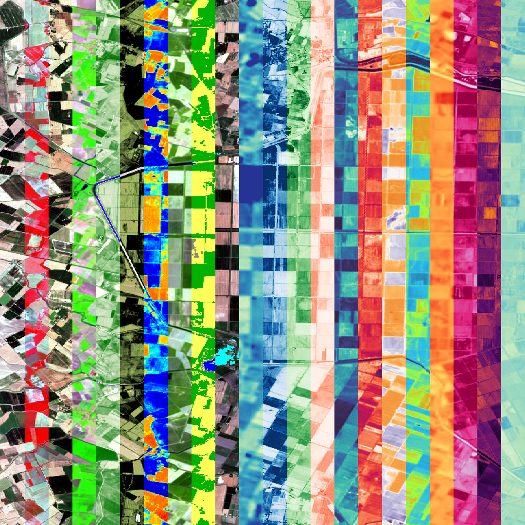
- Multispectral (e.g., Sentinel-2): ~13 broad bands
- Hyperspectral (e.g., EnMAP): 200+ narrow bands
Example: Sentinel-2 false-color images often display vegetation in bright red using the NIR band — a useful trick for forest monitoring.
Satellite Remote Sensing: Understanding Resolution Types by Geoawesome
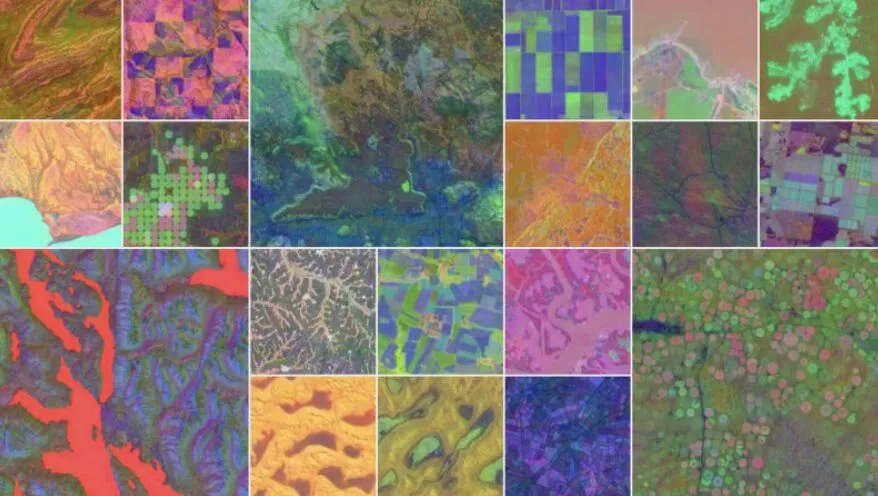
Image Types: Multispectral, Hyperspectral, Panchromatic, and SAR
🔹 Multispectral Imagery
Captures data in 3–15 broad bands across the spectrum.
Example: Sentinel-2, Landsat 8, PlanetScope
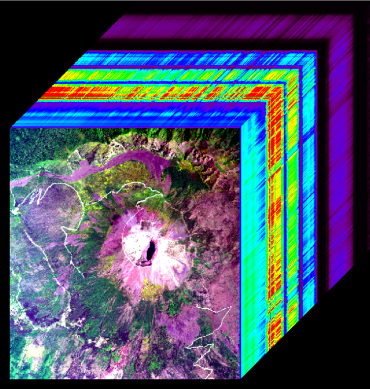
🔸 Hyperspectral Imagery
Captures data in hundreds of very narrow bands.
Used for: mineral exploration, precision agriculture
Example: PRISMA, EnMAP, AVIRIS
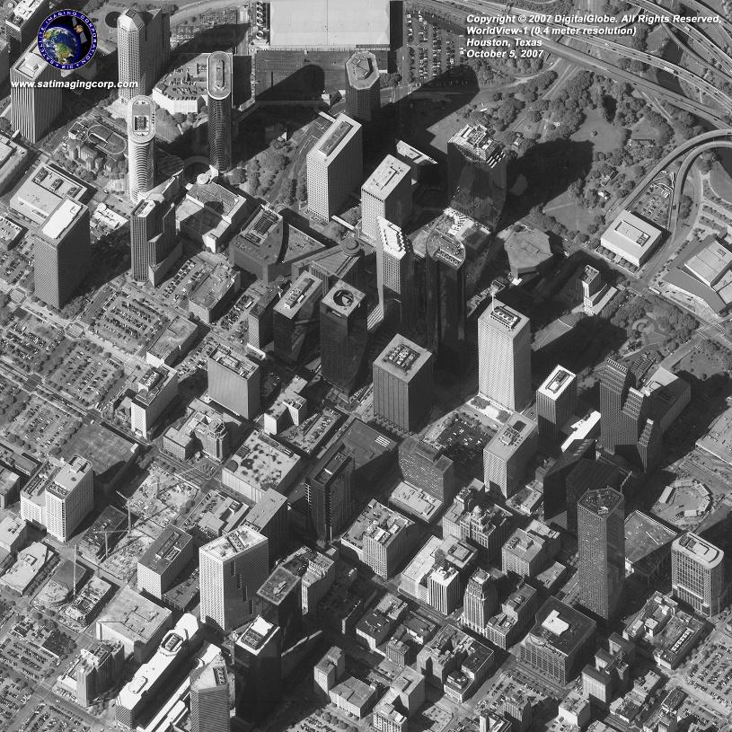
⚫ Panchromatic Imagery
Single-band grayscale image, but with very high spatial resolution.
Example: WorldView-2 Panchromatic (0.46 m)
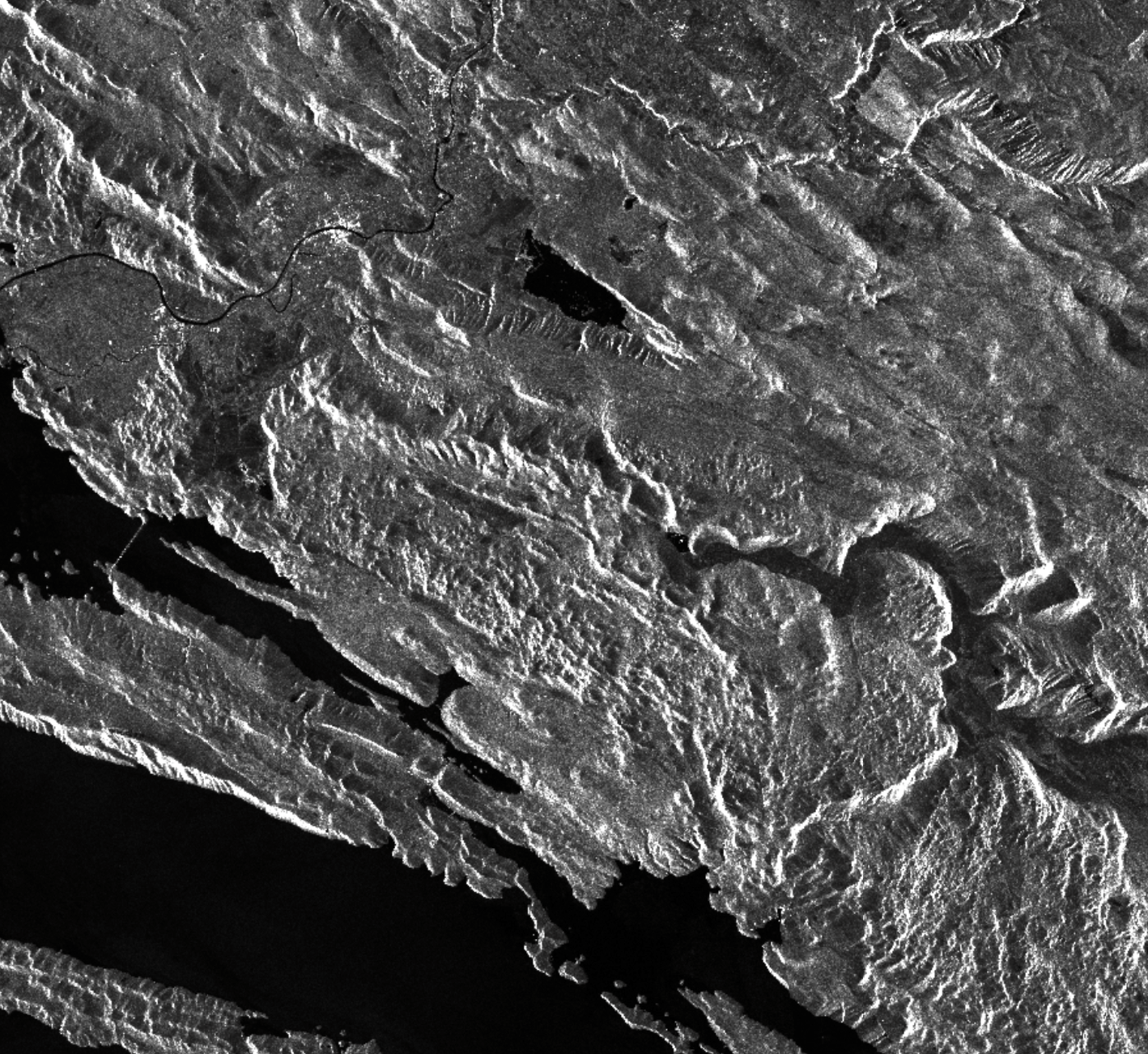
⚪ SAR (Synthetic Aperture Radar) Imagery
Active microwave sensor that captures data regardless of weather or daylight conditions. Used for: surface deformation, flood mapping, forest biomass, and sea ice monitoring. Example: Sentinel-1, RADARSAT-2, TerraSAR-X. Read more.
Where to Explore Remote Sensing Imagery
The best part? Much of this data is freely available and easy to access with no prior experience.
Platforms for Visualization
- Sentinel Hub – EO Browser
Explore Sentinel and Landsat data, compare dates, apply indices like NDVI. - NASA Worldview
Near-real-time MODIS and VIIRS imagery, overlays for fires, dust, storms. - USGS EarthExplorer
Download full scenes of Landsat, SRTM, and more. Includes metadata. - OpenAerialMap
Crowdsourced UAV imagery is perfect for humanitarian work or local mapping. - Google Earth Engine
For advanced analysis with code, free for research and nonprofits.
Understanding the building blocks of remote sensing—pixels, bands, and resolution—opens up a world of possibilities. With free platforms and data sources at your fingertips, now is the perfect time to explore Earth from above.
Explore More:
How do you like this article? Read more and subscribe to our monthly newsletter!


#Environment

Next article
Google has announced Google Earth AI, a collection of state-of-the-art geospatial AI models and datasets aimed at tackling critical global challenges. This initiative is explicitly “designed to help businesses, governments, scientists, and researchers tackle the urgent needs of our planet”. In essence, Google Earth AI packages years of AI research into tools that can drive real-world decisions – from climate resilience to urban planning – marking a pivotal moment where GeoAI (geospatial AI) is moving into mainstream enterprise use.
From Climate Crises to Cities: AI Models with Real-World Impact
What sets Google Earth AI apart is its broad focus on pressing issues and its immediate integration into widely used platforms. Rather than isolated experiments, these models are already powering features used by millions via Google products. Key capabilities demonstrated include:
- Flood Forecasting – Covering river basins in 100+ countries, providing flood warnings up to 7 days in advance for 700 million people. Such forecasts help governments and insurers mitigate disaster impacts.
- Wildfire Tracking – Live in 27 countries through Google Maps, AI detects wildfire boundaries to aid emergency responders. This can protect assets and inform utility companies during wildfire seasons.
- Cyclone Forecasting – AI-driven cyclone predictions are being tested by the U.S. National Hurricane Center, enhancing early warnings for storms. Industries like energy and logistics benefit from better storm preparedness.
- Traffic Optimization (Project Green Light) – Deployed in 20 cities across 4 continents, AI-optimized traffic lights reduced stops by 30% and emissions by 10%. This improves urban mobility and air quality – gains for city planners and businesses alike.
These examples illustrate how GeoAI is directly saving time, costs, and even lives. A climate tech executive noted that models like these are already having “a real impact” in reducing emissions and addressing climate priorities. Indeed, Google’s flood and wildfire models are not just tech demos; they deliver actionable insights, such as sending flood alerts via Search and Maps that communities and enterprises rely on.
A Platform Approach – AI + Big Data for Decision Support
Beyond individual models, Google Earth AI represents a platform approach to geospatial intelligence. It builds on Google’s recent Geospatial Reasoning research, which combines powerful AI (like Google’s upcoming Gemini generative AI) with rich global datasets. The goal is to deliver insights, not just data – answering complex spatial questions for users. For example, an enterprise could ask which areas are most at risk from both flooding and population growth, and an AI assistant could analyze satellite imagery, maps, and demographic data together to provide a clear answer. Google Earth AI’s integration with Google Cloud and Earth Engine means businesses will likely be able to tap these models via familiar interfaces and cloud APIs, embedding geospatial AI into their existing workflows.
Crucially, Google is targeting usability. “Simplicity above all” is emerging as a theme in GeoAI – meaning these advanced tools are being packaged so that non-experts can leverage them. In practice, a sustainability officer at a corporation might use a Google Earth AI dashboard to monitor wildfire threats to facilities, or an agribusiness analyst might get automated drought impact assessments, without needing a data science team to build models from scratch. This lowering of technical barriers is key to enterprise adoption.
Business Value and an Eye on Sustainability
The business case for Google Earth AI lies in better decisions through better data. By fusing satellite imagery, weather data, mobility data, and more, the suite can provide a “rich understanding” of factors like population dynamics and urban mobility. For enterprise decision-makers, this translates into insights such as where to prioritize infrastructure investments, how to optimize supply chains against climate risks, or where insurance exposure is highest – all informed by AI analysis at a global scale. Tech investors see this as unlocking new value from Earth observation data, long an underutilized asset in many industries.
It’s worth noting that Google’s move also aligns with growing corporate interest in ESG (environmental, social, governance) and climate resilience. As companies face pressure to report and reduce their environmental impact, tools like Earth AI could provide the data and forecasts needed to act. For instance, automated deforestation alerts or carbon footprint analyses derived from satellite data can feed into sustainability reports and strategy. One industry observer remarked that initiatives like Earth AI “turn data into real-world climate solutions”, exactly the kind of momentum global agencies have been calling for.
That said, some have raised the question of AI’s own footprint – the energy and CO2 cost of training these massive models. Google’s stance, echoed by the International Energy Agency, is that the net impact depends on using AI in service of sustainability. In other words, if models like Earth AI help cut more emissions (through optimization and early warnings) than they produce, they are a clear win for the planet and business continuity.
A Turning Point for GeoAI in Enterprise
Google Earth AI’s launch is a strong signal that GeoAI is maturing from research labs to operational use in enterprises. With a tech giant offering “AI-as-a-service” for geospatial problems, we can expect faster uptake across industries. The optimistic view – and one largely shared by geospatial professionals – is that these tools will unlock the business value of Earth observation data that has existed for years but was hard to fully utilize. From smarter resource allocation in governments to new insurance products based on real-time risk assessment, the possibilities are expanding.
GeoAI is here, and it’s increasingly accessible. Enterprise leaders should take note that harnessing satellite and sensor data with AI is no longer an exotic, experimental endeavor – it’s becoming a competitive necessity.
Did you like the article? Subscribe to our monthly newsletter!

