
Planet data can be integrated into your geographic information system (GIS) of choice — be it ArcGIS, QGIS, or Google Earth Engine — to help you uncover new insights and perform rich analysis.
There are three simple integration pathways to bring Planet data into your GIS workflow:
- Desktop GIS Integrations: Search, access, and analyze Planet’s catalog of daily, global imagery directly from ArcGIS Pro or QGIS — just download the plugin.
- API-First Platform: Planet offers extensive APIs that allow you to build data pipelines and design custom integrations, whether it’s built on ArcGIS, open source software, Google Earth Engine, or cloud and web mapping platforms.
- Streaming Web Services: If you are working with GIS software and looking for the simplest way to access Planet imagery, consider streaming Planet data to any software that supports the Open Geospatial Consortium (OGC) WMS or WMTS standards.
This article will help you decide which of these integration strategies is best for you and provide resources to help you get started. To get access to Planet data, reach out to our team.
If you want to focus only on integrating with ESRI ArcGIS software, you can also watch our on-demand webinar, Integrating Daily Imagery From Planet With ArcGIS.
WHY INTEGRATE PLANET DATA INTO YOUR GIS WORKFLOW?
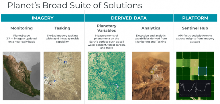
Driven by the mission to make change visible, accessible, and actionable, Planet is a leading provider of global, daily satellite imagery and geospatial solutions. Founded in 2010 by three NASA scientists, Planet designs, builds, and operates the largest Earth observation fleet of imaging satellites. Today, Planet’s global daily Earth data, analytics, and powerful cloud-based tools are all accessible through Planet Insights Platform.
You may want to add Planet’s near-daily data and insights to your GIS workflow for a number of reasons, including:
- Mapping: You want to enrich your maps with more current satellite imagery than what’s available in off-the-shelf basemaps so that your imagery matches other GIS data more closely.
- Sharing: You have Planet imagery, and you want to make it available on your GIS platform so that the rest of your organization can access the imagery for their workflows.
- Analysis: You want to use your preferred remote sensing analysis tools (e.g. for machine learning or spectral analysis) available in your GIS software to generate insights from Planet data.
1. DESKTOP GIS INTEGRATIONS
If you use the ArcGIS or QGIS desktop applications, you can download a Planet plugin that enables you to discover, preview, stream, and download Planet Basemaps and imagery. You can seamlessly integrate these datasets into your GIS workflows and leverage your preferred analysis tools to streamline your work.
Check out this demonstration or take a look at the developer resources page for the Planet Add-in for ArcGIS Pro to learn more about what you can do.
Similarly, the Planet QGIS Plugin provides access to Planet’s satellite imagery directly from QGIS. Learn more on the developer resources page for the Planet QGIS plugin.
Sentinel Hub — now part of Planet Insights Platform — also offers a plugin for QGIS, and can be used together with the Planet plugin to enable imagery analysis and streaming in QGIS. Using the Sentinel Hub Plugin, you can bring satellite imagery — including Planet imagery — into your GIS for visualization purposes, including evaluating accuracy, detecting change, assessing land cover based on time series, and more with a Sentinel Hub account.
WEB SERVICES-BASED INTEGRATIONS
The desktop GIS plugins remain a great option for accessing Planet data, however, you may want to consider web GIS integration options, including our API-first and web services-based integrations for a number of reasons, including:
- Scalability: These are typically more scalable, especially when using cloud platforms
- Shareability: These approaches make data more easily shareable through Web GIS tools
- Speed: They offer the lowest-latency path to imagery
2. API DELIVERY INTEGRATION
Planet Insights Platform is designed to be API-first so that developers can build workflows that scale and integrate with their choice of software. When your use case requires more advanced GIS capabilities, Planet Insights Platform offers extensive APIs that allow you to build your own imagery pipeline into your ArcGIS environment or Google Earth Engine.
Hosting Planet imagery in your GIS application enables you to use advanced tools, store imagery in your cloud of choice, or utilize third party imagery management tools, such as mosaic datasets and image services in ArcGIS.
Planet does this through delivery to your cloud storage destination; we support Google Cloud Storage, AWS, Azure, and more. In addition to cloud delivery, you can use our APIs to work with remote sensing analysis platforms, such as:
- Sentinel Hub: Part of Planet Insights Platform, Sentinel Hub is a scalable Earth observation platform that provides tools for advanced remote sensing analysis, customizable visualization, and simple OGC streaming.
- ArcGIS Image: You can deliver data to your cloud storage to be used with ArcGIS Image Server, or you can create custom data pipelines to ArcGIS Image for ArcGIS Online by downloading and uploading to ArcGIS Online to be used with ArcGIS Image for advanced imagery analysis. Here is a code sample that you can use to publish PlanetScope Imagery to ArcGIS Image for ArcGIS Online.
- Google Earth Engine: Directly deliver data to Google Cloud Storage to be used with Google Earth Engine. Learn more at the Google Earth Engine Delivery Integration page on our developer page.
When you choose to deliver data to your own cloud storage destination or off of Planet Insights Platform, there are a couple of extra steps to make the imagery usable in your workflow. For example, you may need to configure GIS software to read images from cloud storage.
Or, if you choose to build your own imagery technology stack, you’ll need to:
- Implement event-driven processes to handle cloud deliveries and index the imagery in a catalog, such as STAC
- Manage tile server infrastructure for serving imagery that handles compositing and dynamic rendering server-side
- Build an analysis service for imagery processing to handle workflows like compositing, data fusion, and multi-temporal analysis
- Create security and authentication to manage access to imagery
However, you don’t have to build this yourself — Planet Insights Platform can manage all of this for you, and you can use APIs to immediately start to analyze, visualize, and stream satellite imagery when you choose to deliver data to Sentinel Hub.
3. STREAMING WEB SERVICES
Our cloud-native web services integration is one of the most flexible pathways to integrate Planet data into your GIS workflow.
If you are working with GIS software and looking for the simplest way to access Planet imagery, leverage the Open Geospatial Consortium (OGC) API to stream WMS and WMTS services directly into your application of choice — be it any ArcGIS software, QGIS, Felt, or any other web mapping platform.
Planet Insights Platform provides ways to set up customized OGC services in a serverless environment that makes for a much simpler implementation — no need to download, rehost imagery, or use cloud storage — just stream imagery directly from the platform into your applications.
On Planet Insights Platform you’ll find all kinds of great tools, including customizable rendering options to filter clouds, display spectral indices, false color composites, and more. You’ll find extensible and flexible APIs for developers to customize interaction with OGC services to filter through time, change visualizations, and view analysis outputs in GIS software. For example,
- ArcGIS: ArcGIS Online and Enterprise support working with WMTS and WMS services — simply add the URL to your imagery from Planet and you can have imagery in your maps in minutes. Check out this demo to see what this looks like in action.
- QGIS: Sentinel Hub offers an integration for QGIS users. Sentinel Hub can create a remote sensing infrastructure where local analyses aren’t scalable. In the integration, you can:
- Access all of your configurations for customizable visualizations
- Dynamically generate OGC services for given date ranges to compare over time
- Share data and maps without embedding API keys
In QGIS, Sentinel Hub can be your remote sensing infrastructure where local analyses aren’t scalable. This video shows three layers from Sentinel Hub in QGIS: two seven-day composites of PlanetScope from two different weekends, and then an NDVI difference with a custom symbology applied with a mask for NDVI change <-0.2.
Learn more about Planet Insights Platform capabilities.
GETTING STARTED WITH PLANET
Planet has flexible integration options for any workflow, be it through the desktop application plugins, the API-first platform, or our OGC streaming web services. Find the workflow that works best for you, and get started today.


#GeoDev


Next article

Geographic Information Systems (GIS) and geospatial science have transformed how we understand and interact with our world. As part of our History of GIS series, we have put together a list of the top six figures in GIS and geospatial.
These individuals come from a diverse array of backgrounds and have made substantial contributions to the industry, highlighting the important roles played by all, including women and people of color, in advancing the field.
We consider it important to note that the contributions of many women of color in the early days of GIS and geospatial sciences may have been overlooked or underreported due to historical biases and lack of documentation.
The industry is continuously working towards better recognition and inclusion of diverse voices and contributions. We recognize this gap and want to provide a more comprehensive and inclusive account of the industry’s history, ensuring all significant contributions are properly acknowledged and celebrated.
Here’s a brief look at six of the most renowned personalities who have shaped these industries.
Dr. Gladys West is a pioneering mathematician whose work was crucial in developing the Global Positioning System (GPS). Born in 1930 in Virginia, she overcame racial and gender barriers to become one of the first Black women to work as a mathematician at the Naval Surface Warfare Center.
West’s groundbreaking contributions include creating precise mathematical models of the Earth’s shape, which were essential for GPS accuracy. She managed the Seasat project, the first satellite to monitor oceans, and worked on GEOSAT, improving our understanding of satellite geodesy.
Her work on accounting for gravitational and tidal forces on the Earth’s surface enabled precise satellite orbit calculations, forming the foundation of modern GPS technology. Dr. West’s achievements were belatedly recognized, including her 2018 induction into the Air Force Space and Missile Pioneers Hall of Fame.

Dr. Gladys West
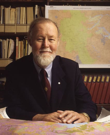
- Jack Dangermond
Jack Dangermond is the co-founder and president of Esri (Environmental Systems Research Institute), the world’s leading geographic information system (GIS) software company.
Born in 1945 in Redlands, California, Dangermond earned degrees in environmental science and urban planning before founding Esri with his wife Laura in 1969.
Dangermond’s contributions have been crucial in popularizing GIS technology and making it accessible to a broader audience. Esri’s ArcGIS software is one of the most widely used GIS platforms worldwide.
Under his leadership, Esri has become the global leader in GIS technology, serving over 350,000 organizations worldwide. His work has had a profound impact on various industries, from urban planning to environmental conservation. Dangermond is also known for his philanthropic efforts, particularly in environmental conservation and education.

Jack Dangermond. Source
Valerie Thomas is an American scientist and inventor best known for her work at NASA, where she developed image-processing systems for the Landsat program, the first satellite to capture real-time multispectral images of Earth.
Born in 1943 in Maryland, Thomas earned a degree in physics from Morgan State University and joined NASA in 1964. Her contributions to the Landsat program revolutionized Earth observation and resource management.
In 1980, she patented the illusion transmitter, a device that creates 3D optical illusions, which has applications in surgery and television.
Although now retired, Valerie Thomas, at 80 years old, continues to be a highly respected figure in her field and an inspiration to many. Her groundbreaking work and perseverance in the face of challenges serve as a powerful example for those pursuing careers in science and technology, especially for individuals from underrepresented groups.
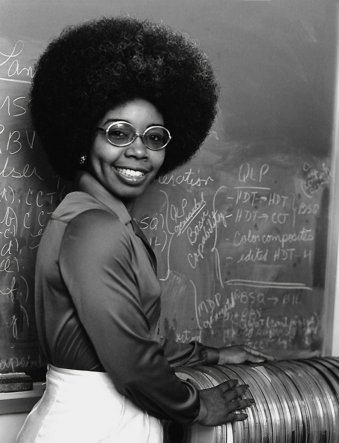
Valerie Thomas. Source
- Roger Tomlinson
Often referred to as the “Father of GIS,” Roger Tomlinson is best known for his pioneering work in the development of GIS technology.
In the early 1960s, he created the Canada Geographic Information System (CGIS), the world’s first operational GIS, for the Canadian government’s Canada Land Inventory.
This groundbreaking work laid the foundation for modern GIS technology and its widespread application across various sectors. Tomlinson coined the term “geographic information system” and was instrumental in establishing GIS as a distinct field of study and practice.
Tomlinson’s contributions to the field have had a lasting impact on spatial analysis and data management practices. Throughout his career, Tomlinson continued to shape the GIS industry through his consulting work, academic contributions, and advocacy for geographic education.
Roger Tomlinson. Source
While not from the earliest days of GIS, Dr. Kwan has been a pioneer since the 1990s in using GIS for analyzing human activity patterns and transportation. Her work has been crucial in developing time-geographic methods in GIS.
Dr. Kwan received her Ph.D. in Geography from the University of California, Santa Barbara in 1994. She has held professorships at several prestigious institutions, including the University of Illinois at Urbana-Champaign and the Chinese University of Hong Kong.
Her groundbreaking work has focused on integrating time and space in GIS analysis, developing innovative methods for studying human mobility, environmental exposure, and health issues. Dr. Kwan’s research has been instrumental in advancing the field of time geography within GIS, providing new ways to analyze and visualize complex spatio-temporal data.
Dr. Kwan has received numerous awards for her contributions, including the American Association of Geographers (AAG) Stanley Brunn Award for Creativity in Geography and the AAG E. Willard and Ruby S. Miller Award.
Her work continues to influence a wide range of applications in urban planning, public health, and environmental studies.

Dr. Mei-Po Kwan
- Waldo Tobler
Waldo Tobler (1930-2018) was a renowned geographer and cartographer who made significant contributions to the field of Geographic Information Systems (GIS) and spatial analysis.
Known for formulating the First Law of Geography, “Everything is related to everything else, but near things are more related than distant things”, Tobler’s contributions to spatial analysis and computational geography have been foundational in GIS.
Tobler pioneered the use of computers in geographic research, focusing on mathematical modeling and graphic interpretations. He was a key figure in the development of digital cartography and spatial analysis techniques.
As a professor at the University of Michigan and later at the University of California, Santa Barbara, Tobler played a crucial role in advancing GIS technology and theory. His work earned him numerous honors, including membership in the National Academy of Sciences and the ESRI Lifetime Achievement in GIS Award.
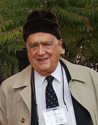
Waldo Tobler. Source
The Future of GIS: Inclusion and Innovation
The field of GIS and geospatial science has been shaped by the contributions of numerous influential figures. Their work continues to inspire and drive progress in the ways we analyze and interact with the world around us.
Inclusion and equity in GIS and geospatial science are not just moral imperatives; they are essential for innovation and progress. When we create environments where all voices are heard and valued, we unlock new potentials for solving complex spatial problems. The contributions of underrepresented groups have often led to novel applications of GIS technology, addressing issues that might otherwise have been overlooked.
As we look to the future of GIS and geospatial science, it’s clear that fostering diversity, ensuring inclusion, and promoting equity will be key to tackling global challenges.
By celebrating the contributions of pioneers from all backgrounds and actively working to make the field more accessible and inclusive, we can ensure that GIS and geospatial science continue to evolve and serve the needs of our diverse global community.
Did you like the article about top figures in GIS? Read more and subscribe to our monthly newsletter!

