

Recently, I was helping a friend with a super cool project where his team needed high-resolution satellite imagery and an elevation model. Knowing a thing or two about remote sensing, I offered to assist. The experience was long and painful; I drafted and re-wrote a post that walked through the entire process but decided not to post all the gory details.
The project centers around a detailed ground-based scan of a UNESCO Heritage site. The goal is to allow users to virtually visit and tour the site from a museum thousands of miles away. To provide a rich and immersive experience, we needed to simulate the surrounding landscape and enter the need for satellite data.
Over four years ago, Joe Morrison, a “controversial industry figure,” wrote a post about how The Commercial Satellite Imagery Business Model is Broken. He has made good progress at Umbra, enabling anyone to task a Synthetic Aperture Radar (SAR) satellite via the SkyFi app. This assumes the user understands what SAR is, knows how to use SAR, understands how “tasking” works, knows about the SkyFi app, and is willing to part with about $1,000.
Unfortunately, that’s not what I needed; let the games begin.

A good place to start is a well-known portal that is free, open, easy to use, and provides a robust inventory of all the data and sources available for any location.
(This does not exist.)
In a satellite buyer utopia, one could draw a circle on a map and easily understand every time a sensor observed that area of the world. The user could preview the data, read the relevant metadata, and receive instructions on how to access it. This includes optical, radar, multispectral, hyperspectral, low and high resolution, elevation models, open data, and licensable data.
This is no different from any other buying experience, like when you type in a desired product in Google Shopping or Amazon. For some reason, in the satellite / remote sensing / geospatial industry, we like to make things difficult, slow, and frustrating. In my quest to find data sources, I visited over 15 different platforms, each with its own unique: website, login requirements, buying experience, pricing, and access to a limited amount of data.
USGS Earth Explorer, Copernicus Sentinel, Maxar, Airbus, Planet, Satellogic, Blacksky, UP42, SkyFi, SkyWatch, Opentopography, Intermap, Apollo Mapping, Landinfo, AWS
Frustratingly, most of these ended up with “CONTACT SALES.” Even more frustratingly, most of the sales departments did not contact me. (Is there another industry in the world where the buyer is willing to spend thousands of dollars and gets ghosted? Seriously, if there is, please let me know)


Some apps, like SkyFi and SkyWatch, were intuitive, easy to use, and transparent with pricing. They have both made great progress, and I applaud them for working on simplifying this process. There were a couple of reasons why, ultimately, I couldn’t use their platforms: 1) I needed very high-resolution data in a remote area of the world, and those images simply didn’t exist on the apps. And 2) I needed a digital elevation model (DEM) to bundle with the image.
(Note: SkyWatch has recently added Maxar imagery, which is good progress, but I wouldn’t have bought it due to its high pricing and restrictive licensing. I also needed elevation data.)
As an aside, many buyers like me have gone through this same process and provided a wealth of feedback (and frustration). I’m not unique. And to give credit, many fine folks at many different companies are working tirelessly on this problem. Frustratingly, there is something like a 100:1 differential in investing to build satellites compared to investing in delivery platforms, i.e., the technology that actually allows end users to consume data. (In 2023, private investment in satellites was ~$2B versus ~$20M in delivery platforms.)
Fortunately, I knew a guy: Brock at Apollo Mapping. Brock and his team were super responsive and helpful, and their portal, ImageHunter, has a lot of data sources, including both imagery and 3D DEMs. We ended up licensing Airbus Pleiades imagery and WorldDEM Neo from Apollo as it had the desired resolution and was much more affordable than Maxar.
It took me about two months to procure the data from start to finish, and I’ve been in this industry for about twenty years. Can you imagine going through this if you’re unfamiliar with all the acronyms, sources, providers, terminology, and insane licensing?
If you’ve never read an EULA for a satellite image, here are some common restrictions. If legal stuff is boring to you, skip to the Sheldon GIF.
- Usage Restrictions – Many licenses specify whether the imagery can be used for commercial, research, or government purposes. In many cases, imagery is licensed for internal use only, meaning it cannot be shared or resold. (Satellite companies love this because it allows them to sell the same image ‘n’ many times)
- Redistribution and Sharing – Most providers prohibit or strictly control imagery redistribution, sublicensing, or public sharing. If redistribution is allowed, it often requires additional fees or agreements. This includes basic usages such as making it viewable online.
- Time-Based Restrictions – Some licenses limit how long the imagery can be used before requiring renewal or removal from storage.
- Geographic and Sector Restrictions – Certain areas or industries (such as defense or intelligence) may be restricted due to national security concerns or export control laws.
- Resolution and Modification Limits – Some licenses restrict users from modifying or enhancing the imagery in ways that could violate intellectual property rights.
- Attribution Requirements – Users may be required to credit the satellite imagery provider when using the images in publications, reports, or analyses.
- Export Controls and National Security Laws – Regulations like the U.S. International Traffic in Arms Regulations (ITAR) and Export Administration Regulations (EAR) may restrict the distribution of high-resolution satellite imagery to certain countries or entities.
- Analytical Derivatives – Some agreements specify whether users can create and share derivative products based on the imagery, such as maps, models, or analytical reports. In other words, the provider wants to control the type of analysis on the image.
Indeed, one doesn’t actually purchase a satellite image; they purchase a license to use a satellite image in a very restrictive manner.
Satellite providers even restrict the user’s ability to compare data sources and quality and impose restrictions on making direct comparisons with other providers:
- Benchmarking Prohibitions – Some providers explicitly forbid users from conducting or publishing performance comparisons (e.g., resolution, accuracy, spectral quality) between their imagery and that of competitors.
- Quality Assessments & Reverse Engineering – Licenses may restrict users from analyzing or reverse-engineering the imagery to evaluate its performance in a way that could be used to compare providers.
- Public Disclosure Restrictions – Even if comparisons are allowed internally, publishing or sharing results publicly (e.g., in reports, marketing materials, or scientific papers) may require prior approval from the provider.
- Derivative Work Limitations – Some providers restrict the creation of derivative works that could be used to highlight differences in quality, coverage, or accuracy between competing imagery sources.

The CEO of Uber is infatuated with improving the experience and has notably said, “Uber sucks.” He puts himself in the consumer’s and driver’s shoes to figure out ways of improving. Uber’s CEO Says He’ll Always Find a Reason to Say His Company Sucks | WIRED
I would LOVE to see this from the leadership teams of satellite companies:
- Find reasons why your company sucks. (your end users are willing to help)
- Stop bragging about your specs; we don’t care.
- Anyone who wants a leadership position at a satellite company should first be required to go find and buy a license. Give them a few thousand dollars and a laptop.
- FIX licensing. Just because it’s been done like that since the 90s doesn’t mean it needs to continue.
- Umbra is excluded from the above statement.

Umbra has wisely realized the advantages of open licensing far outweigh the potential “risk”. Open data receives more usage, more sharing of data and analysis, more adoption, happier customers, and ultimately grows the market.
In 2008, the USGS Landsat program adopted an open license and usage and adoption flourished. Today, the value of that dataset is estimated at over $25B in annual economic value: Landsat’s Economic Value increases to $25.6 Billion in 2023 | U.S. Geological Survey
Here is the worst part of the story, something I feel sick about. We didn’t use the data … At the end of this all, it just didn’t meet the project’s needs. Had we been able to test the data beforehand, we could’ve avoided this. Another problem in this buying journey is the lack of sample data. Sure, it does exist, but we were looking at cities like Cleveland for the sample, with the site being completely different. Satellite providers *will not* provide samples of the client’s exact location for testing purposes. There are exceptions, of course, like if we had $1M to spend. However, they believe they are “losing money” if they have to make custom samples for projects of this size.
Where do we go from here:
- We need to build a better solution than these monolithic siloed platforms. It sucks as a consumer. We need an Amazon.com for geospatial data.
- Existing EULAs should be incinerated. If an Open License isn’t feasible right now, the market would be OK with a simple, human readable, standardized commercial license that permits users to USE data.
- All satellite companies should adopt and deploy STAC.
-
Last, I’d love to find a satellite provider who would like to partner with me, not just take my money. Allow me to experiment with data. Don’t squeeze me on licensing. Treat me like a customer.
Note: The article was originally published on Kevin’s Substack and has been republished here with the permission of the author.

#GeoDev


Next article

In today’s fast-paced world, having immediate access to reliable, high-resolution satellite imagery is essential for informed decision-making. Whether it’s for monitoring property boundaries, assessing risks, gathering evidence for legal disputes, or tracking construction progress, clear and up-to-date satellite imagery has become an essential tool for informed decision-making. Recognizing these pressing needs, OnGeo Intelligence offers the innovative Satellite Imagery Report service—a solution designed to simplify access to detailed, high-resolution satellite images for everyone.
Introducing the Satellite Imagery Report Service
The Satellite Imagery Report is a comprehensive service available on OnGeo-Intelligence.com that bridges the gap between advanced geospatial data and everyday applications. It provides immediate access to satellite imagery without the burden of account registration, ensuring that users can quickly obtain the insights they need—anywhere on the globe.
Service Overview and Key Features
The Satellite Imagery Report, branded as OnGeo™ Intelligence, is designed to simplify the acquisition of satellite imagery. Key features include:
- Accessibility Without Registration: Users can order reports without creating accounts, subscriptions, or contracts, making it ideal for one-off needs. This aligns with the service’s goal of bringing geospatial technology to every household, as noted on their website.
- Global Coverage and Resolution: The service covers any location on Earth, utilizing data from a range of satellite constellations, including Sentinel-2, SPOT, Pléiades, Pléiades Neo, WorldView-1, -2, -3, -4, and GeoEye-1. Resolutions range from 0.3 m to 10 m, with the latter sharpened to 2.5 m per pixel using AI, enhancing detail for analysis.
- AI-Enhanced Imagery: The sharpening process, likely leveraging super-resolution AI, improves 10 m resolution images to 2.5 m per pixel, as confirmed by external sources on AI image sharpening techniques. This is particularly useful for detailed land parcel analysis, with additional channels like near-infrared (NIR) and short-wave infrared (SWIR) available for advanced GIS applications.
- Delivery Format and Speed: Reports are delivered in a PDF format, including original, cloudless, georeferenced data, AI-sharpened visualizations, and remote sensing indices such as NDVI (Normalized Difference Vegetation Index), NDWI (Normalized Difference Water Index), and NDMI (Normalized Difference Moisture Index), accompanied by charts for monitoring vegetation health, water content, and soil moisture. Delivery times are impressive, with low-resolution scenes available in an average of 5 minutes and high-resolution data within 48 hours.
- Cost and Additional Options: Pricing starts at $12.99 per report, with options to become a member for potential cost savings. The service also offers data packages for download, enabling further analysis by users with GIS capabilities.
For a closer look at the service details, check out our dedicated page on: Satellite Imagery Report.
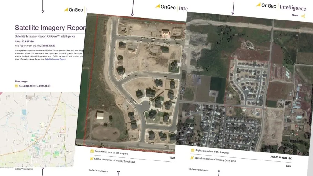
Download a Sample Satellite Imagery Report OnGeo Intelligence.
The following table summarizes the key technical specifications:
| Feature | Details |
| Price | From 12.99 USD per single report |
| Delivery Time | Low-resolution: average 5 minutes; High-resolution: up to 48 hours |
| Content | Original cloudless georeferenced data, AI-sharpened visualization in PDF, remote sensing indices |
| Data Sources | Sentinel-2, SPOT, Pléiades, Pléiades Neo, WorldView-1, -2, -3, -4, GeoEye-1, etc. |
| Resolution | Up to 0.3 m, with 10 m images sharpened to 2.5 m per pixel using AI |
| Use Cases | Property disputes, insurance claims, construction monitoring, environmental observation, legal evidence |
| Process | Select period and location, search archives, order report, receive via email |
| Technology Partners | AI & Machine Learning, Airbus Intelligence, Maxar Technologies, AlterGeo Holding |
A Simple, Intuitive Ordering Process
The process of obtaining your Satellite Imagery Report is designed to be as straightforward as possible. Here’s how it works:
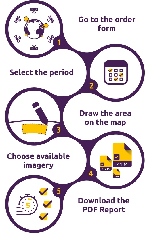
Iconographic showing simple steps needed to order a Satellite Imagery Report.
- Go to the order form: Order Satellite Imagery Report.
- Choose Time Period: Specify the date range, with archives dating back to 2008 for historical analysis.
- Select Location: Users pinpoint the area of interest on an interactive map, ensuring precision.
- Select Resolution: Choose between high-resolution (0.3 m) or enhanced 10 m images, based on need.
- Order the Report: Select from available cloud-free images, with the system searching archives in minutes. Receive the PDF report and data package via email, with low-resolution reports delivered almost instantly and high-resolution within 48 hours.
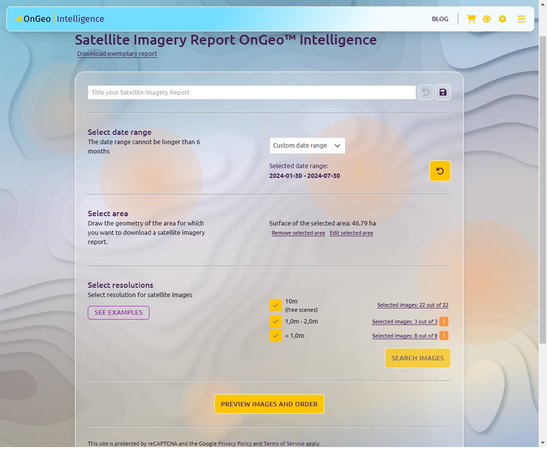
Screenshot of the Satellite Imagery Report order form.
Practical Applications for Everyday Needs
The Satellite Imagery Report isn’t just for experts—it’s a versatile tool that meets the demands of a wide array of practical applications:
- Legal Proceedings:
Utilize high-resolution images as indisputable evidence in property disputes or boundary conflicts. - Real Estate and Property Monitoring:
Keep a close watch on property changes and developments, ensuring accurate records for market assessments or personal oversight. - Insurance Claims:
Access current, precise imagery to support risk evaluations and streamline the claims process. - Environmental Observation: Monitor changes like deforestation, water level fluctuations, or urban expansion, useful for community awareness or personal interest.
- Construction and Investment Projects:
Monitor the progress of construction projects and verify that developments remain on schedule and within scope.
This democratization of access is unexpected for many, as satellite imagery was previously the domain of specialists, but OnGeo-Intelligence’s approach makes it a practical tool for anyone, enhancing decision-making in personal and community contexts.
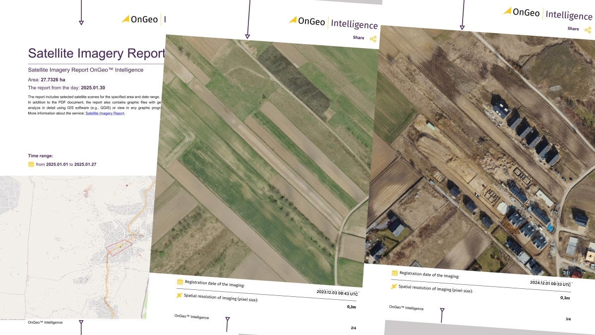
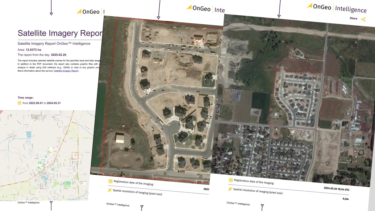
Sample Imagery OnGeo Intelligence.
Client Storytelling: A Home Built Together, and a Map from Space in a Divorce Case
Anna and Thomas, a married couple with a long history, stood in court for a divorce case. The point of contention was the house they had built together. Thomas received the land as a gift from his parents before the marriage. He argued that the house was solely his because it stood on his land. However, Anna claimed that the house was built during the marriage, thanks to their joint financial and work contribution, and that she was entitled to a share of the property.
The case was difficult. Irrefutable evidence was needed as to exactly when the house was built. Memories and bills were not enough. That’s when Anna’s lawyer came up with an idea – the OnGeo Intelligence Satellite Imagery Report.
“We ordered a report for that particular plot,” says Anna. “And what turned out? Archival satellite images clearly showed that at the time of the wedding, there was only a small, unfinished outbuilding on the plot. The house we lived in began to be built only after we got married.”
“The satellite images were key! The court, seeing this evidence, ruled that the house became part of the marital property. I got my due share. It was a difficult time, but the report from OnGeo Intelligence helped me get back what I had worked hard for,” Anna says with relief. Thanks to modern technology, justice was served.
Conclusion
OnGeo Intelligence’s Satellite Imagery Report service is a game-changing solution that addresses the growing demand for rapid, reliable, and easy-to-access satellite imagery. By eliminating registration barriers and providing comprehensive, high-resolution data in an intuitive PDF format, this service is perfectly tailored for both professionals and everyday users alike. Experience the future of satellite imagery and make informed decisions with confidence.
Use the order form and check available satellite imagery for your property
Note: This is a sponsored article by OnGeo Intelligence, published by the Geoawesome Team to provide valuable insights to our readers and the geospatial community. It has been reviewed to ensure it meets our editorial standards for quality and relevance. In case you have any questions or comments, please reach us at info@geoawesome.com

