#Business

Planet Labs acquired Google’s satellite imagery unit Terra Bella
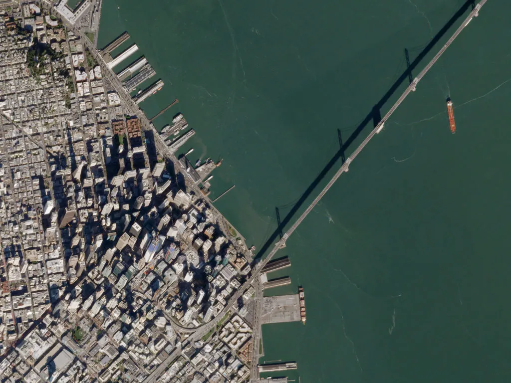
The Planet Labs, one of the leading satellite and mapping startups, announced that it had acquired the Terra Bella – a satellite imaging unit of Google.

Google started its short romance with satellite imagery back in 2014 when it acquired Skybox Imaging and rebranded it to Terra Bella last year. Two years ago Google paid for Skybox $500 million. The value of the deal with Planet Labs was not disclosed, but it must have been way smaller as the startup funded in 2010 would not afford it otherwise.

According to Crunchbase, Planet Labs gathered so far $183.1m in 5 funding rounds. It’s not a lot taking into account that maintaining a constellation of 60 satellites and a few hundred employees generate huge operating costs. According to TechCrunch, the value of the deal is close to $300m, and it seems probable, especially knowing that most of the deal is not cash, but Google is simply taking a stake in the startup. The company has also agreed to purchase satellite images captured by Planet in a multiyear contract.

So why Google decided to sell?

With the formation of Alphabet as an overarching parent company, Google is rationalising its various lines of business. Licensing satellite imagery from a dedicated provider, rather than owning it seems to make a lot of sense. Satellite imaging is a business where scale matters. The more satellites you have, the lower the operating costs, and the higher the temporal resolution you get. In that business, the value comes not necessarily with higher spatial resolution (pixel size) but with providing a very often refresh rate of the same location. Planet Labs co-founder and chief executive Will Marshall wrote in a blog post.

“We’ve long admired what the team at Terra Bella has achieved, and we think the SkySat constellation of 7 high-resolution satellites is highly complementary to Planet’s existing medium resolution 60-satellite fleet,” Marshall wrote. “The former enable regular, rapidly updated snapshots of select areas of the globe at sub-meter resolution; the latter regular, global coverage at 3-5 meter resolution. The two systems under one roof will be truly unique and will enable valuable new capabilities.”

In parallel, the company also announced that it would soon launch another 88 satellites allowing it to photograph all 57.3 million square miles of the Earth’s surface, up from roughly 19 million square miles today.

It seems like the future of Earth Observation is just behind the corner.

Say thanks for this article (0)
The community is supported by:
Become a sponsor
#Business
#Business #Featured
The Earth Observation Hub Report: 2024 Industry Trends and Analysis
Avatar for Muthukumar Kumar
Muthukumar Kumar 03.13.2024
AWESOME 4
#Business #Contributing Writers #Fun #People
History of GIS | ESRI – A Pioneer in GIS Technology
Sebastian Walczak & Nikita Marwaha Kraetzig 07.26.2024
AWESOME 1
#Business
Geo Addressing Decoded Part 1: Why Does Geo Addressing Matter?
Aleks Buczkowski 04.16.2024
AWESOME 6
Next article
#Science

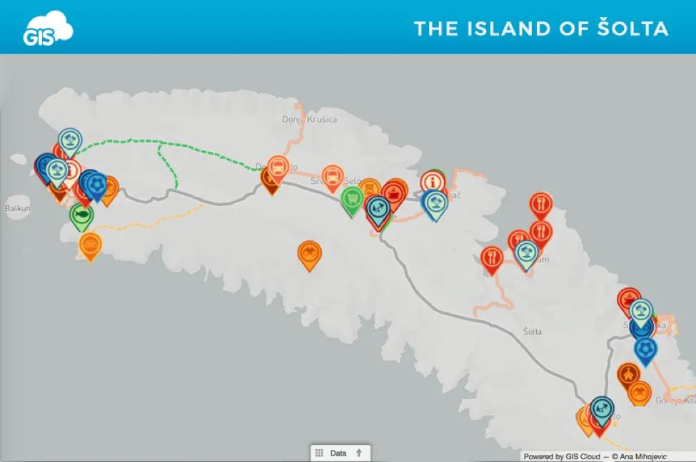
GIS In Tourism – Building an Interactive Map of the Island of Šolta

Tourist maps are one of the most widespread uses of GIS and online mapping, that is accessible and useful for a wide variety of people. Knowing that Tourism is one of the crucial industries to many communities around the world, having an interactive map with all the information necessary for tourists is of great use for all who take part in the related activities. Except for tourist maps, GIS can be also used for different planning and analyzing activities such as building tourist resorts and facilities. It is a great tool for tourist guides, who can have a good overview of important infrastructure, tourist offering, historic places. They can also use maps for planning optimal routes for sightseeing and determining shortest distance between important places, and these are just some of the examples of potential uses of GIS in Tourism.

So, let’s see one real life example of building an interactive Tourist Map using GIS Cloud in a project done by Geography student Ana Mihojevic.

Inspired by the example of the City Crikvenica Map Portal, she decided to create a map of the Šolta island in Croatia. As she also participates in the local tourist offering, this was a great opportunity to use skills as a geographer for a purpose that also has a value for both her own business and a local community.

Šolta is a small island with ten villages, that became an attractive tourist destination for as many as 15 000 local and international travelers, and 150 000 overnight stays per year. This also affected the growth in the number of local services, restaurants and attractions. Creating a map was a perfect way to include all of these novelties in one place, also enabling local community to add their own offering and get additional exposure.

Challenge

As there are already small-scale maps available in tourist guidebooks and basic Google Map overview of Šolta, the idea was to include and validate all the existing info, update old and incomplete data, and collect new information relevant for tourists.

The prerequisites for building an interactive map of the island were:

  • Collecting the existing and adding new data
  • Having a possibility of quick and easy update of attributes, as information about certain locations is often changed (working hours, phone numbers…)
  • Select and categorize relevant information
  • Adjust the data to a user through filters, different layers, zoom and search options
  • Sharing the data with public through a simple and intuitive interface

Solution

Ana Mihojevic used GIS Cloud to create an interactive portal using database from websites of the Tourist Board of Šolta and My Šolta Association.

The information on the websites was listed, but it missed a spatial component – visualisation on a map. In GIS Cloud Map Editor, the information was organized and visualised on a map in just a few days. Ana used polylines to display roads important for tourists (main roads, walking and bike routes…). After that, different point features and their attributes for particular locations and parts of the infrastructure were added. Search by address option in GIS Cloud made it easier to add these points, and it was also more precise than manually pinpointing them.

Using Map Editor for updating attributes was easy and simple, it is an interactive and user-friendly interface for both tourists and local community. The map was published through Map Portal application, therefore accessible by local population and tourists.

Access the portal directly on this link.

The content was organized in 6 groups of features:

  • Services: tourist information centers, restaurants, bars, transport etc.
  • Activities: what to do while on holidays on Šolta. In this group are listed beaches, sports centers, rent a bike or scooter businesses.
  • Attractions: a list of Šolta’s highlights like viewpoints from where you can see the panorama view, over the nearby islands or mainland. There is also a list of churches and locations where you can to try some of Šolta’s authentic products.
  • Shops: locations of all supermarkets, green markets and a fish farm as well.
  • Healthcare and Safety: information about pharmacies, police and fire departments, and an ambulance in case of emergency.
  • Spatial Information: all the roads of Šolta, macadam roads, bike routes and seaside promenades.

Interactive Tourist Map of the Šolta Island is a project that demonstrated how to create a useful project for purposes of Tourism using GIS, in just a couple of days. This map gives an opportunity for local businesses to show their offerings while helping tourists in orientation and exploration of the island.

Ana Mihojević states that this type of map could even be used for other purposes and other industries such as real estate. It could be easily updated to a map of accommodation with listed hotels, private accommodation or even yacht marinas.

You can find the original article, written by Ana Mihojević, on GIS Cloud official blog.

Want to create a tourist map of your area? Sign up and try it for yourself.

Read on
Search