#Business #Featured #Ideas

Google released Maps for Apple Watch… and it’s a disappointment

Apple Watch Photo Geoawesomeness

This week Google released an update to Google Maps for iOS that adds a companion app for your wrist if you own Apple Watch. This is an interesting news as it indicates that Google is not ignoring the smartwatch platform of it’s competitor. It’s actually the first Google’s app for Apple’s new device.

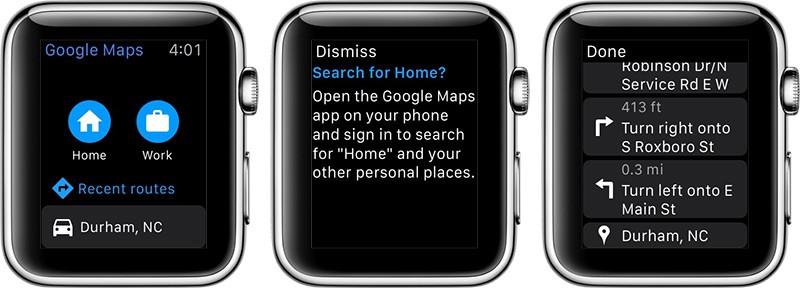
But this would be it when it comes to good news. Google seems to have put in a pretty minimal amount of effort for this first release. Unlike Apple’s native map application, Google’s app is limited to offering text and icon directions. There’s not an actual, full-color map included in Apple’s app. It’s a bit disappointing.

Apple Watch Google Maps Geoawesomeness

My favourite feature in Google Maps is traffic. Every morning when going to office I use Google Maps to choose the route and to avoid being stuck in traffic. Although the app supports all the modes of transportation, it provides just an estimated travel time rather than actual traffic info and alternative routes.

Although the app is a little bit disappointing we can forgive Google this time as it’s the first release of the app. Next time we won’t be that forgiving;).


Say thanks for this article (0)
The community is supported by:
Become a sponsor
#Business
#Business
Geo Addressing Decoded Part 1: Why Does Geo Addressing Matter?
Aleks Buczkowski 04.16.2024
AWESOME 6
#Business #Events #Featured
The Future of Navigation: How Satellite Data Shapes Map Innovation
Avatar for Muthukumar Kumar
Muthukumar Kumar 10.29.2024
AWESOME 1
#Business #Environment #Featured
Unlocking the Future: Key Trends in Geospatial Technology for 2025
Aleks Buczkowski 12.25.2024
AWESOME 2
Next article
#Environment #Featured #Ideas

The most complete global map of forests available yet

Very interesting research has been published in Nature magazine. Researchers created the most detailed map of forests around the world. All the previous attempts to estimate the number have been done based on satellite images. The number of trees around the world was estimated at the level of 400 billion. Although remote imaging reveals a lot about where forests are, it doesn’t give an answer to how dense the forest is.

This time researches decided to take a dual approach. They gathered data from various existing ground-based counts of trees covering about 430,000 hectares around the world. These counts allowed them to improve tree-density estimates from satellite imagery. Then the researchers applied those density estimates to areas that lack of high quality ground data.

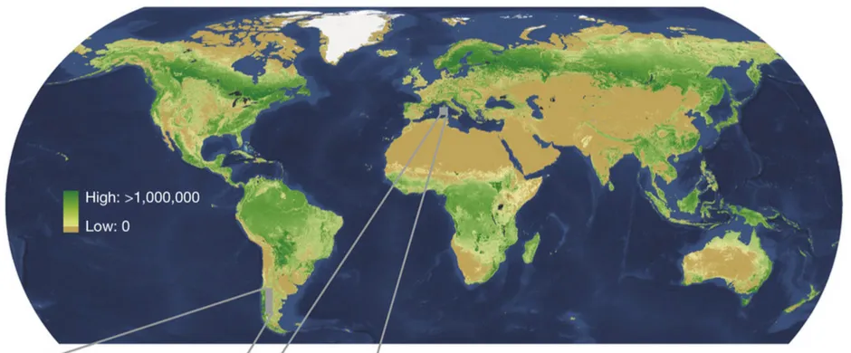
With this approach researchers calculated that the actual number of trees around the world is at the level of 3 trillion, so 8 times higher than previously counted. The result of this research has been published in the form of the density map.

Tree-map-Geoawesomeness

The highest tree densities, calculated in stems per hectare, were found in the boreal forests of North America, Scandinavia and Russia. These forests are typically tightly packed with skinny conifers and hold roughly 750 billion trees, 24% of the global total. Tropical and subtropical forests, with the greatest area of forested land, are home to 1.3 trillion trees, or 43% of the total.

The study also estimated that we are cutting 12 billion trees a year. With that paste we will grub up the whole planet in less than 300 years… Frightening!

Source: Nature

Read on
Search