
For decades, the geospatial industry has focused on powerful, data-driven tools for creating maps. But for designers and content creators, the workflow has always been a painful one. They’re often forced to jump between complex GIS software and their preferred design environment, like Adobe, leading to wasted time and frustrating results. Creating beautiful maps for your design projects shouldn’t be a pain.
If you’re a designer or content creator, you’ve probably felt the frustration of trying to get a high-quality, accurate map into your workflow. Getting a map from a GIS tool like QGIS into a design program required a long, tedious process. You had to harvest the data, do all your edits, and then export it in a format that Adobe could hopefully read. Even then, you’d often end up with a map that had messy layers or was just a raster image wrapped in a vector file. So what is the solution? The team at Mapcreator has built a solution with their new Adobe extensions, designed to put the power of true vector maps right at your fingertips.
You don’t have to take us at our word. Check it out yourself and let the community know what you think! You can sign up for a Mapcreator account here and even more good news and a special offer for our community! Use the code GEOAWESOMEMAP to get a 50% discount on the Professional package for one year.
The Problem: A Tricky Workflow
Before Mapcreator’s extensions, creating maps for design and motion graphics was a tedious process. Even with expertise, designers would often find themselves stuck in a cycle of exporting from one tool and importing into another, then spending even more time cleaning up layers that were broken and disorganized. Street names might be broken into single, un-editable characters, and the overall process was anything but seamless. The end goal was to create accurate, beautiful maps without ever leaving the design environment, a challenge that seemed insurmountable.
The Solution: An Extension Built for You
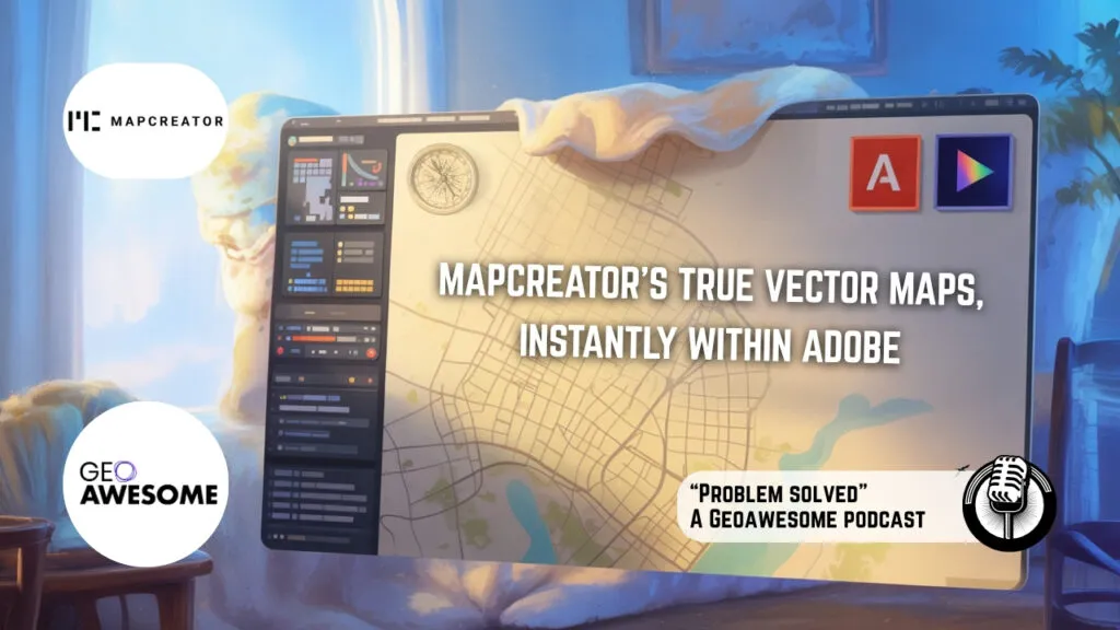
Mapcreator’s Adobe extension was born from a simple observation: users were already downloading maps from Mapcreator and pulling them into Illustrator to make tweaks. The company decided to make that process easier. The extension, available for both Illustrator and After Effects, cuts out the steps of exporting and importing. You can now generate a fully layered, high-quality, and scalable true vector map directly inside your Adobe application.
The core philosophy was simple: rather than building yet another standalone tool, they decided to integrate with the software designers already use. The goal was to remove friction and save time.
Here’s how it works:
- Illustrator: The extension lets you generate a fully layered and editable vector file directly inside Illustrator with just a couple of clicks. It also comes with a free script that “stitches together” broken text on paths, making street and river names easy to edit.
- After Effects: The After Effects extension works similarly, communicating with the Illustrator extension in the background to bring fully editable vector files directly into your composition. This eliminates the tedious step of converting files in Illustrator just to open them in After Effects. You can even apply pre-designed animation templates to specific layers for a quick, professional look.
The result is a map that is truly scalable and ready to be customized to fit your brand or story. Mapcreator’s maps are delivered with a neat, logical layer structure, so you can easily edit entire categories like parks or roads, not just individual paths. This is something the team is particularly proud of, as it’s a feature not commonly found in other tools.
The Genius is in the Details
So, what makes these “true vector” maps so special?
- Flawless Layers: Mapcreator’s vector maps are delivered with a clean, logical layer structure. This means that every park is a park and every capital is a capital, allowing you to easily apply changes to an entire group. This is a massive improvement over maps from other tools that can be split into hundreds of different, disorganized layers.
- True Scalability: Unlike a bitmap wrapped inside an SVG, these maps are true vectors. They can be scaled to any size without losing quality or becoming pixelated.
- Workflow Optimization: For users of After Effects, the extension is a game-changer. It gets the vector file directly into the program without having to go through Illustrator first. This means you can get your story out there faster, which is critical for a large user group like newsrooms where news is constantly breaking. The extension even offers pre-templates for animations, like a fade-in effect on country names, to help you save even more time.
Ready to Solve Your Mapping Problem?
Whether you’re in a newsroom needing a map in seconds or a motion graphics designer looking to streamline your workflow, Mapcreator’s Adobe extensions are designed to help you focus on what really matters: telling your story.
Want to give it a try?
Learn more with these resources


#Insights


Next article
In a first installment of Geoawesome Founder Real Talk series, a platform dedicated to fostering peer-to-peer networking and sharing entrepreneurial journeys in the geospatial industry, I had the interviewing Zac Canders, the co-founder of DataCapable. Zac’s story is a powerful reminder that building a successful company isn’t just about having a great idea; it’s about a relentless focus on solving a problem, constant adaptation, and building the right team. The recording of the entire interview including audience Q&A is available here.
The Origin Story: A Problem-First Approach
The idea for DataCapable was sparked by the aftermath of Superstorm Sandy. Zac, a former utility operations professional, recognized the immense challenge of coordinating resources and understanding the scope of damage during large-scale emergencies. He envisioned a system where anyone could take a photo and get it onto a map, providing a real-time, ground-level view of an event. This problem-centric approach, rather than a technology-first one, became the foundation of DataCapable’s mission.
In the company’s early days, this vision manifested in using social media data, specifically from platforms like Twitter, to identify and map events like power outages. This was a novel application of technology at the time. Today, the company leverages advanced AI and machine learning to analyze a variety of data sources, from open-source platforms to real-time audio analytics, to detect and communicate threats like wildfires and active shooter events.
Technology and the Human-Augmented AI Model
Zac explained that while technology continues to evolve at a rapid pace, the goal remains the same: to provide actionable insights. The company’s progression from simple data scraping to sophisticated AI models was driven by both customer demand and the team’s desire to build a more robust platform.
A key takeaway from Zac’s experience is the concept of human-assisted AI. He believes that while AI algorithms are powerful for detecting events, a human element is still crucial for verification and adding context. This hybrid model ensures accuracy and reliability, preventing the kind of “noise” that machine learning models can produce, such as misinterpreting a photo of a drink for a mudslide.
Building the Team and Navigating Partnerships
According to Zac, a successful startup isn’t just about the product; it’s about the people. He emphasized that building a strong team and fostering a healthy company culture is paramount. His advice for aspiring entrepreneurs includes:
- Be passionate about the problem: Deep engagement with your industry’s community is essential for long-term success.
- Focus on getting paid: While building a great product is important, a business cannot survive without a strong focus on sales and timely payments.
- Don’t give your product away for free: Always attach a value to your product or service, even in pilot programs, to demonstrate its worth.
- Build a strong support system: Delegate non-core tasks like accounting and legal work to professionals. This frees up founders to focus on building the business.
- Don’t burn out: Set boundaries and maintain a healthy work-life balance to avoid becoming jaded.
DataCapable’s growth was also significantly aided by strategic partnerships with industry leaders like Esri and Amazon Web Services. Zac highlighted the value of these relationships, stating that they provided opportunities to expand their reach and gain credibility within the geo-tech space. He strongly recommends that new founders engage with these ecosystems to find mentors, pilot clients, and build a network of advocates.
The recording of the entire interview including audience Q&A is available here.
In the 2nd edition of Geoawesome Founder Real-Talk, we are interviewing Marco Bernasocchi, founder of OpenGIS.ch. You can register for the live interview and community networking event here.

