
In recent times, foundation models have improved fields of natural language processing and computer vision. Now, they’re improving Earth observation (EO) – assisting researchers, climate scientists, and policy-makers to extract deeper insights from satellite data with minimal supervision. If you’re wondering how to get started with these powerful models, this guide will help you take the first steps and understand what’s possible.
Why Foundation Models Matter for EO?
Foundation Models in Earth observation by Geoawesome
These capabilities make foundation models an excellent starting point for EO workflows. Training large models from scratch or relying on classical remote sensing techniques is no longer necessary!
Step-by-Step Guide to Getting Started
Step 1: Set Up Your Environment
To run most foundation models for EO, you’ll need:
- Python 3.8+ environment
- Jupyter Notebook or Google Colab (Colab is easiest for beginners)
- Basic ML libraries: torch, numpy, matplotlib, transformers, and domain-specific libraries like rasterio or earthengine-api
- GPU access (recommended but not mandatory): Colab provides a free GPU runtime, which speeds up inference
Step 2: Choose Your Foundation Model
Several excellent ready-to-use notebooks showcase how to apply foundation models in EO tasks. Depending on the specific use case, typical tasks include segmentation, classification, time-series embedding, or generation.
Quick Comparison Table
Step 3: Launch a Notebook
Let’s walk through launching and using one of these models: TerraMind.
TerraMind was launched as an open-source foundation model on Earth Day (April 22, 2025), in collaboration with IBM, ESA Φ-lab, DLR, and Jülich Supercomputing Centre, marking the first any-to-any multimodal generative model for Earth observation.
- Visit the TerraMind GitHub repository.
- Open the folder notebooks/ and choose a demo notebook like terramind_v1_base_sen1floods11.ipynb.
- Click on “Open in Colab.”
- Change the runtime to GPU: Runtime > Change runtime type > GPU.
- Run each cell step-by-step:
- It will load model weights
- Process Sentinel-1 or Sentinel-2 imagery
- Perform flood segmentation or image generation
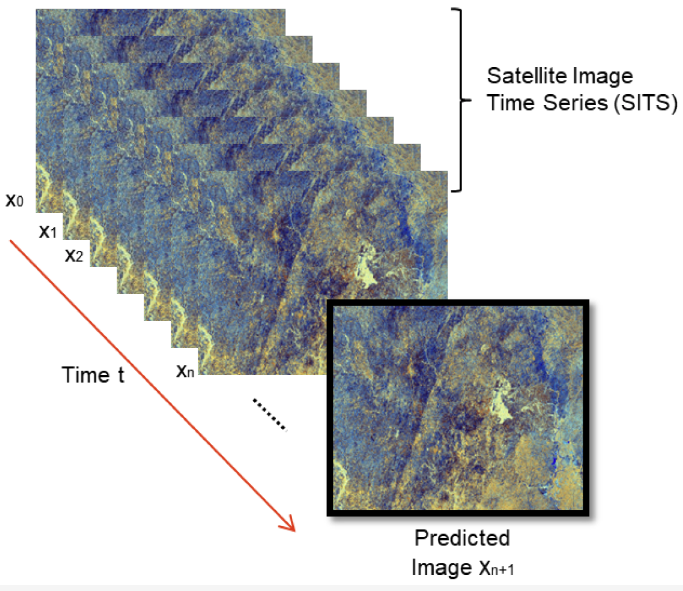
Within minutes, you’ll see visualizations of input and output images, showcasing how the model interprets EO data.
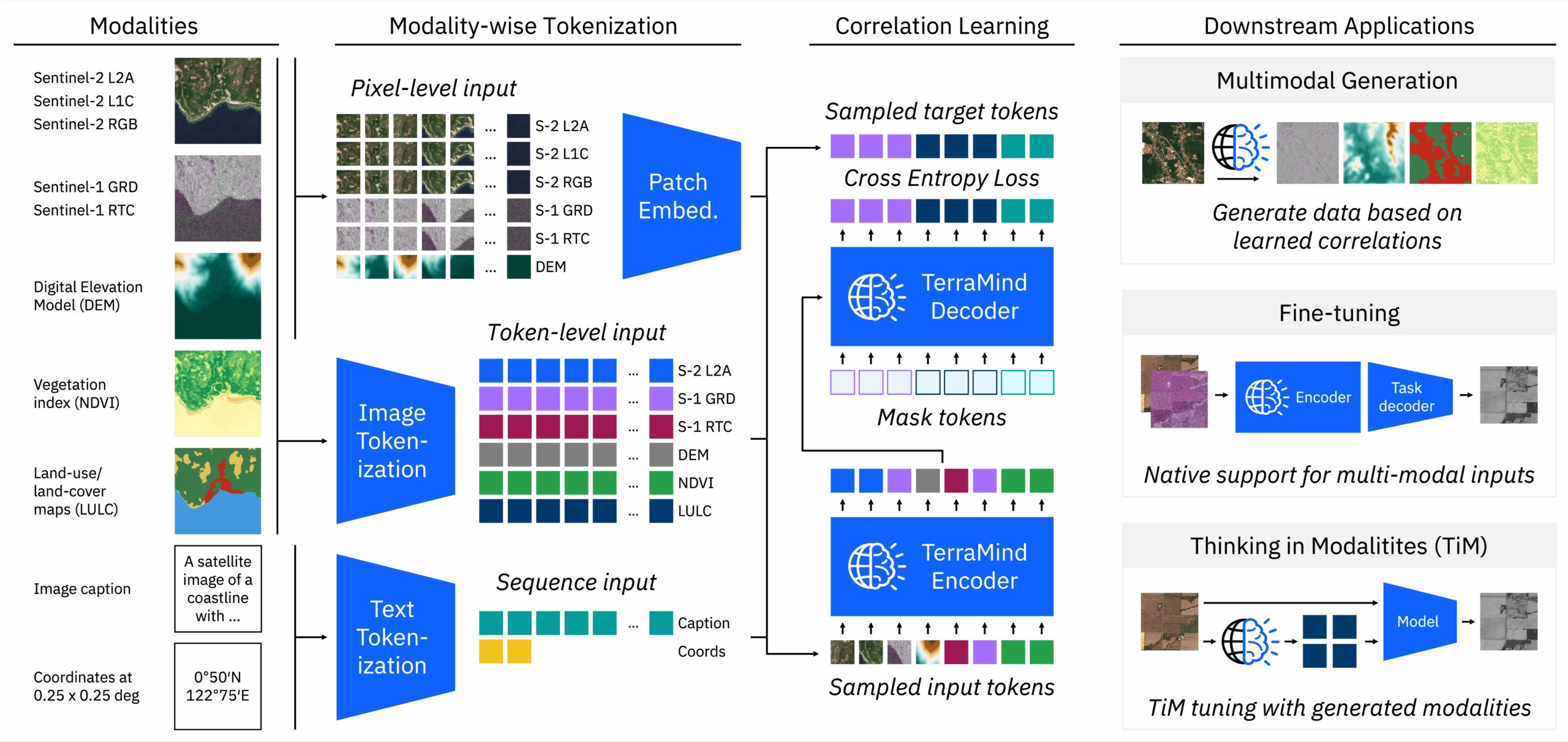
TerraMind: model workflow
Step 4: Explore Other Use Cases
Here are highlights of other foundation model notebooks you can try:
- Two core demos: Prithvi-EO (temporal segmentation) and TerraMind (disaster response)
- Run entirely on Colab
- Great for learning about segmentation and transfer learning in EO
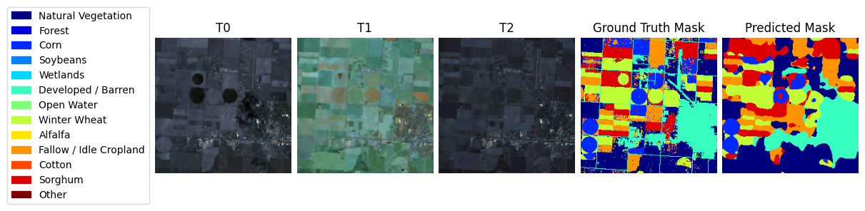
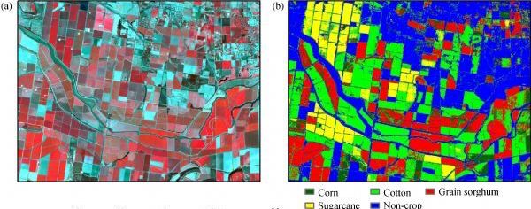
ML4EO: crop classification
- Offers a semantic understanding of EO through embeddings
- Launch via Binder or JupyterLab on your local machine
- Use it to search, cluster, or visualize satellite scenes
- Time-series embedding model designed for remote sensing
- Uses Sentinel-1, Sentinel-2, and ERA5 inputs
- Built to integrate with Google Earth Engine
- One of the best-organized and most comprehensive model bases for EO available today
- Features an extensive, curated list of ready-to-use models and techniques with a strong emphasis on reproducibility and simplicity
- Categories include:
- Segmentation: land cover, building footprints, water bodies
- Classification: land use, deforestation, urban mapping
- Regression: biomass estimation, crop yield
- Super-resolution and denoising using diffusion models
- Foundation embeddings like EarthPT and contrastive models
- Many models are runnable directly in Colab, requiring minimal setup
- A valuable resource for anyone serious about scaling EO analysis with deep learning

Satellite-image-deep-learning Collection: Image Captioning
Satellite-image-deep-learning Collection: Crop classification
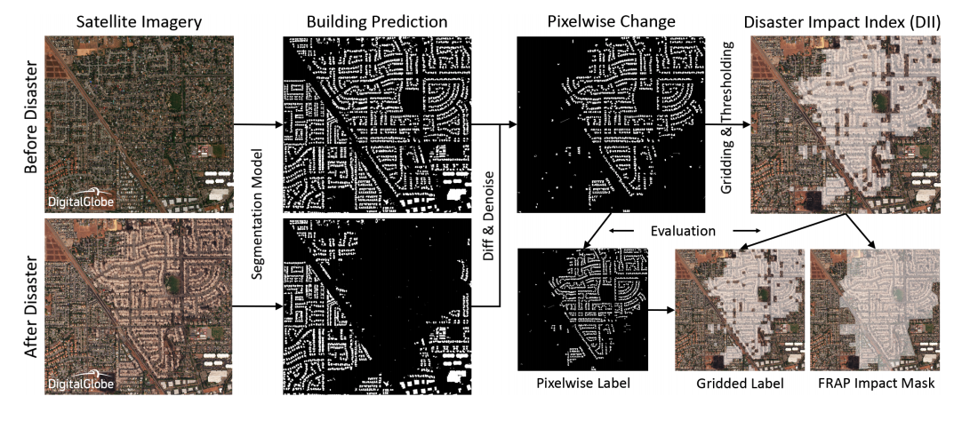
Satellite-image-deep-learning Collection: Disaster response
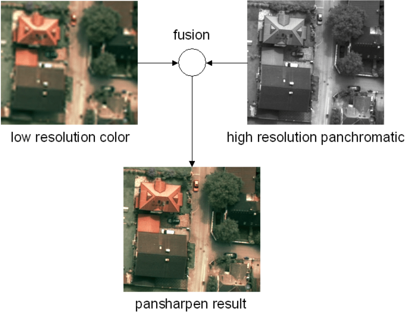
Satellite-image-deep-learning Collection: Pansharpening
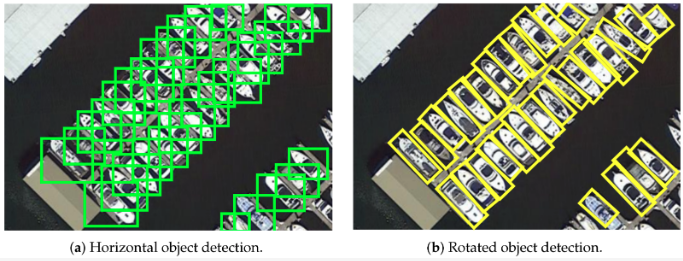
Satellite-image-deep-learning Collection: Object detection
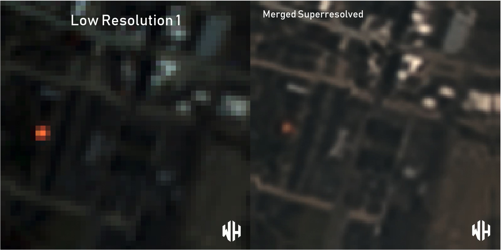
Satellite-image-deep-learning Collection: Super-resolution
Satellite-image-deep-learning Collection: Time-series
Step 5: Customize or Fine-Tune
Once you’re comfortable running the base models:
- Modify inputs: Use your own GeoTIFFs or Sentinel tiles
- Fine-tune: If you have labeled data, adapt the foundation model to your region or problem
- Integrate with pipelines: Use model outputs in QGIS, dashboards, or Python apps
Most foundation models allow flexible configuration and output customization, making them easy to integrate into your own EO workflows.
Real-World Impact
Applications of Foundation Models in Environmental and Disaster Response by Geoawesome
These capabilities make foundation models especially valuable for NGOs, government agencies, and academic labs that may not have the resources to train deep models from scratch.
Summary: Your Starting Path
- Choose the right notebook based on your use case.
- Launch in Colab or Jupyter, enable GPU, and run through examples.
- Experiment with new inputs or tasks.
- Scale or customize to your EO project needs.
The EO field is entering a new era where foundation models offer plug-and-play intelligence. With open-source tools and notebooks readily available, you can join this transformation today—even if you’re not a deep learning expert.
How to Use Foundation Models for EO Without Coding?
Several platforms have already developed initiatives for no-code or low-code EO workflows. Orbify is a cloud-based platform designed for EO application development, offering ready-made templates and apps that often require no coding at all. Similarly, EOfactory.ai by SkyMap Global provides commercial EO tools for flood mapping, crop monitoring, and other use cases, all powered by ML/AI models running behind the scenes. While Descartes Labs takes an API-first approach, it also includes visual dashboards that allow non-programmers to interact with EO analytics and model outputs. Finally, Microsoft Planetary Computer remains largely developer-focused but includes web-based GUIs and has strong potential to evolve into a more accessible, no-code environment for environmental data exploration.
Final Tip: Stay Curious
These tools are designed to empower you. Explore them. Modify them. Break them and rebuild them. The ability to detect, understand, and act on Earth changes is more accessible than ever.
Want to know more? Check out our article on AI foundation models for geospatial and Earth observation: A new era of Earth understanding.
We’d Love to Hear From You!
Have you tried working with foundation models for Earth observation? Did they help transform your workflow or yield unexpected insights?
Tell us about your experience with foundation models – share your workflows, visualizations, or results. Don’t hesitate to reach out and talk with us: sebastian@geoawesome.com
How do you like this article? Read more and subscribe to our monthly newsletter!


#GeoDev

Next article
Neo Space Group Finalizes UP42 Acquisition: What it Means for Earth Observation Industry

Today, the geospatial community is buzzing as Saudi Arabia’s Neo Space Group (NSG) officially finalized its acquisition of UP42 from Airbus Defence and Space. UP42 – a Berlin-based Earth observation data platform launched by Airbus in 2019 – is now formally part of NSG after the deal’s completion on July 10, 2025. This news marks a significant shift in the Earth Observation (EO) marketplace landscape, especially in Europe, and carries implications for industry players globally. Below, we break down what this development means for Europe’s EO sector, for NSG’s ambitions, for UP42’s future, and for Airbus’s strategy, along with insights from industry experts.
Europe’s Earth Observation Marketplace Shake-Up
The NSG–UP42 deal is the second major acquisition in recent memory involving a top European EO platform – coming hot on the heels of Planet (a U.S. company) acquiring Slovenia-based Sinergise (known for the Sentinel Hub platform) in 2023. With UP42 now under Saudi ownership and Sentinel Hub under Planet, Europe finds itself without a major independent EO marketplace of its own. Some industry observers see this as a concerning trend. After US-based Planet acquired Sinergise, Airbus is now offloading UP42 to Saudi-based NSG. The worry is that European companies and developers may become increasingly reliant on platforms controlled from outside Europe, potentially undermining Europe’s competitiveness in the burgeoning geospatial data economy.
From a strategic standpoint, losing home-grown platforms could limit Europe’s influence over the commercialization of satellite data. Europe has invested heavily in programs like Copernicus (providing free Sentinel data) and nurtured startups in the geo-field, but the monetization and marketplace layer is now largely in foreign hands. This raises questions about whether Europe can foster the next generation of EO platforms or if it will depend on American and now Middle Eastern players for accessing and distributing commercial imagery. Some, however, take a pragmatic view, suggesting that Airbus likely wouldn’t offload its best revenue-producing assets and that UP42 wasn’t core to Airbus’s bottom line. In other words, Europe’s loss of UP42 might not dramatically hurt Airbus, but it does highlight a gap – the absence of a major European-owned EO marketplace – which could be a strategic issue in the long run.
NSG’s Ambitions Get a Major Boost
For Neo Space Group, acquiring UP42 is a bold leap forward that supercharges its capabilities and know-how. NSG is a new space services company launched in 2024 under Saudi’s Public Investment Fund, with a mission to become a global leader in satellite and space services. By bringing in UP42’s technology and experienced team, NSG instantly gains a proven cloud-based platform for ordering and analyzing geospatial data. This acquisition “significantly expands [NSG’s] market reach, deepens its technological expertise, and gains access to a broader range of geospatial assets,” according to the official announcement. In other words, NSG is bridging any technology gaps by absorbing a ready-made platform rather than building one from scratch – a move that demonstrates its big ambitions.
NSG has been actively acquiring companies to build a full-fledged space ecosystem. It looks like they are on the way to becoming a fully vertically integrated firm in KSA, assembling all pieces of the space value chain – from owning satellite infrastructure to providing services and now the digital platform to deliver EO data. Indeed, NSG had already acquired a Saudi geospatial solutions firm (Taqnia ETS) in 2024 and even secured a government permit to provide EO platform services in Saudi Arabia. With UP42 under its wing, NSG can combine satellite data sources, analytical tools, and a global marketplace in one organization. This not only bolsters Saudi Arabia’s domestic geospatial capabilities but also positions NSG as an emerging heavyweight in the global EO arena, signaling that the kingdom is serious about competing in the commercial space sector.
Paving the Way for a Saudi EO Constellation?
NSG’s grab of an Earth observation platform also hints at bigger plans on the horizon. Many in the industry speculate that Saudi Arabia may be laying the groundwork for its own commercial EO satellite constellation. Having a powerful data platform like UP42 is a logical precursor to operating one’s own satellites – you need a way to distribute and derive value from the imagery. UP42 provides NSG with the software backbone to manage and sell satellite data, so the next step could be to feed it with proprietary imagery from Saudi-owned satellites. This strategy would mirror moves by others in the region: for example, the UAE’s company Bayanat has been developing and launching satellites in partnership with firms like ICEYE to build out a constellation and pair it with their geospatial analytics services.
While NSG hasn’t formally announced its own satellites yet, Saudi Arabia’s Vision 2030 emphasizes growing a domestic space economy. The government’s Communications, Space & Technology Commission already gave NSG a license to offer EO platform services, and strengthening “national space infrastructure” is a stated goal. It would not be surprising if NSG’s next move is to invest in or acquire Earth observation satellites (or data rights from them) to create a vertically integrated supply chain – from space to screen. In essence, the UP42 deal can be seen as a strategic puzzle piece: it provides the downstream infrastructure that could encourage upstream investments in an EO constellation. If and when that happens, Saudi Arabia would join the club of nations with indigenous commercial imaging capabilities, using NSG and UP42 to distribute data to customers worldwide. For now, NSG can already leverage UP42’s partnerships with multiple satellite providers (Planet, BlackSky, Airbus, and more), but owning the “eyes in the sky” would truly complete the picture.
A Win for UP42: Stability and Global Growth
From UP42’s perspective, this acquisition is largely positive and opens a new chapter of opportunity. The startup-turned-subsidiary gains something every young tech company craves: financial stability and a long-term-oriented owner. The Earth observation market, while growing, is notorious for its challenges – still relatively limited adoption among enterprise users and tight profit margins on data. Companies like UP42 operate as aggregators and analytics platforms, but they often rely on purchasing imagery from big suppliers like Maxar or Airbus and reselling it. Those large providers set base prices for high-resolution imagery that leave little room for marketplaces to maneuver, limiting pricing flexibility. Additionally, many potential enterprise customers are still in early stages of adopting satellite data solutions, meaning market education and integration take time. In short, the EO sector isn’t an easy win – it requires patience and deep pockets.
Being part of NSG and the oil-funded PIF umbrella should give UP42 the backing it needs to weather this gradual market development. “The acquisition strengthens NSG’s global geospatial capabilities while accelerating UP42’s growth and innovation for customers and partners worldwide,” NSG noted in its announcement. UP42’s CEO, Sean Wiid, echoed that optimism, calling it an “exciting new chapter” and assuring that with NSG’s support, UP42 can continue its mission to streamline access to Earth data and even broaden the platform’s reach without disrupting existing services. In practical terms, UP42 now has a parent that is committed to the geospatial sector for the long haul – likely meaning more resources for R&D, potential expansion into new markets (particularly the Middle East), and the ability to scale up its offerings (such as incorporating new data types like hyperspectral or SAR imagery). Crucially, the company maintains that nothing will change for current users and partners in the near term. Continuity is key: “Our existing services and dedication to our customers continue unchanged,” Wiid emphasized, while underlining that the union with NSG will help drive even more innovation and global impact in the long run.
It’s also worth noting that UP42’s Berlin team and brand remain in place, now as a distinct part of NSG’s geospatial division. This means the platform’s numerous partners – over 80 geospatial data and analytics providers as of the last count – still have a marketplace to sell through, and customers worldwide can still find diverse data sources via UP42’s interface. With NSG’s investment, those partners might see the platform grow its user base and capabilities faster. All told, joining NSG gives UP42 a stronger foundation to fulfill its original vision of “democratizing access” to geospatial data (as Geoawesome previously described UP42’s mission). It’s a reassuring outcome for the UP42 team and community, especially compared to the uncertainty that could have arisen had Airbus simply spun the unit down. Instead, UP42 now has the mandate to expand and succeed globally, backed by an ambitious new owner.
Airbus Sharpens Its Focus on Defense and OneAtlas
For Airbus Defence and Space, the seller in this deal, letting go of UP42 is a logical, if somewhat disappointing, business decision. Airbus originally incubated UP42 to tap into the commercial developer market, but Airbus’s core business in Earth observation has always been anchored in selling imagery (and satellites) largely to government and defense clients. In fact, the vast majority of Airbus’s space imagery revenue comes from large defense and intelligence contracts – some estimates put it at over 80-90% of their EO income. Thus, having an open platform that also offered competitor datasets may not have fit Airbus’s primary strategy or revenue model. By offloading UP42, Airbus can double down on its proprietary services like the OneAtlas platform, which is focused on delivering Airbus’s own satellite data and analytics to customers. A report from Intelligence Online noted that with UP42 off its shoulders, Airbus can concentrate on OneAtlas, and still have its data distributed via UP42 (now as an external channel) without needing to run that marketplace itself.
From a financial perspective, Airbus also avoids pouring more investment into a venture that wasn’t core to its earnings. Airbus might have viewed UP42’s aggregator model as cannibalising their existing market opportunities for direct data sales. In other words, why encourage a platform that lets customers shop around for various imagery providers (potentially opting for a competitor’s data) when Airbus could instead push its own data offerings? Given Airbus’s current financial situation – juggling big defense projects and recovering from satellite launch delays – trimming a non-essential unit likely provided some relief. It’s a short-term focused decision that makes business sense: stick to what brings in revenue (satellites, defense contracts, Airbus imagery) and step back from the role of neutral data broker.
The downside, as many in the European geospatial community feel, is the symbolic loss of Airbus’s only major initiative to engage startups and third-party developers in an open marketplace. UP42 was a novel experiment by Airbus to “democratize access to geospatial data”, and its sale could be read as Airbus retreating from that broader commercial ecosystem. However, Airbus isn’t leaving the commercial EO market entirely – it will continue to develop its OneAtlas suite and sell data (Airbus is even a partner on UP42, so Airbus imagery will still be available on the platform). The company just won’t operate UP42 itself. In the bigger picture, Airbus is aligning with its strength and revenue drivers. As a European aerospace giant, it will prioritize government and defense programs (which, as noted, account for the lion’s share of income) and large-scale projects like building new satellites, while leaning on partners or customers (like NSG/UP42) to handle distribution to smaller commercial users. It’s a bit of a pity from an innovation standpoint, but it aligns with Airbus’s focus on profitability and its main markets.
Reactions and Outlook
The geo community reacted to the NSG–UP42 news with excitement, concern, and optimism. Many congratulated UP42, seeing NSG’s acquisition as validation of the platform’s value. Saudi officials also welcomed the move, viewing it as a boost to the Kingdom’s space ecosystem. However, some acknowledged the “European void” left by the acquisition, questioning Europe’s ability to retain its geo-tech innovations. For NSG and Saudi Arabia, the acquisition signals a strong commitment to space tech, positioning the Middle East as an owner of intellectual property in the EO domain. This could spur competition. UP42’s customers and partners are optimistic, expecting business as usual with potential for platform growth, new data sources, and expanded reach due to NSG’s investment and global network.
In summary, Neo Space Group’s acquisition of UP42 is a landmark event in the Earth observation industry. It underscores a shifting landscape where alliances and ownership are crossing borders – U.S. and Saudi players owning what were once European platforms. It signals the rise of new contenders (like NSG) eager to compete with established space companies on the world stage. And for the team at UP42, it’s the start of an exciting new adventure with resources to scale innovation further. While Europe grapples with the strategic implications, one thing is clear: the geospatial marketplace is evolving quickly, and collaborations like this one could ultimately help bring EO data to more users and applications than ever before. At Geoawesome, we’re rooting for our friends at UP42 and looking forward to seeing how this development helps unlock more value from Earth observation – whether in Europe, the Middle East, or anywhere on our awesome planet.
Did you like the article? Read more and subscribe to our monthly newsletter!

