GNSS Reflectometry: Making use of Multipath for altimeter measurements!
Ask any Geomatics student about GPS/Global Navigation Satellite System (GNSS) Signal Multipath and the first answer you would hear is “Oh, multipath is bad for position accuracy”.
“One man’s noise is another man’s signal” – Anonymous
What is Multipath and Why does it affect the accuracy of your GPS/GNSS receiver?
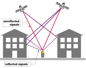
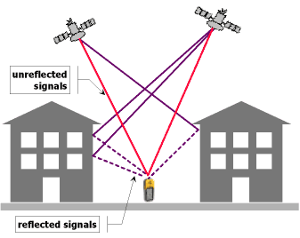 Our GPS/GNSS receivers use the signals sent by the GPS/GNSS satellites to measure the distance between the satellite and themselves using the time taken by the signals to reach the receivers which in turn is used to compute our position. So the key here is the distance. Now when you have signals being reflected from buildings, trees, etc then this leads the receiver to calculate the distance incorrectly because the reflected signals travel longer than the unreflected signals. This unwanted effect is what is termed as Multipath.
Obviously because there is an error in the calculation of the distance which is fundamental to the GPS/GNSS receiver to calculate your position, it affects the position accuracy.
So Multipath is bad and is useless right? Well, yes and no. Yes it is useless for Position Navigation Time (PNT) applications like your Car Navigation device, smartphone and so on but no it is not completely useless. As students and GNSS professionals, we are time and again told multipath is bad and it is true as well, so no one really thinks about using it in any sense. Thankfully not everyone thought so! Enter GNSS Reflectometry (GNSS-R).
The principle behind GNSS-R and its areas of application:
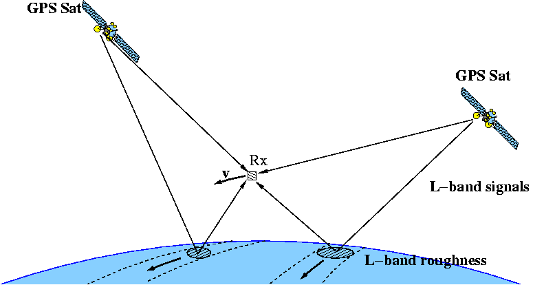
GNSS-Reflectometry uses the multipath signals (hurray!) from GPS/GNSS satellites! Imagine having the GPS/GNSS receiver in a upside-down fashion looking at the earth. It can track and receive only signals that have been reflected from the surface of the earth i.e. those “useless” multipath signals. Imagine this receiver fitted onto a satellite flying over the earth in a low-earth orbit that keeps tracking all these multipath signals over ocean surface. Researchers have done this in an experimental basis and the results look really promising. Using it over land is a bit more complicated as the reflected rays cannot be accurately traced back to their origin, however it is much more easier to do that over the ocean surface.
Well, I really want to be “geo-nerd” and explain everything with equations but remember the book “The brief history of time” by Stephen Hawking? The great man in his author note “says he was told that for every equation, he included in his book, his audience would reduce by half…”! Hmm, interesting thought. I’ll leave it to the GeoGeeks to google the equations then 😉 If you are interested in learning more, have a look at the links – Concept, ResearchPaper.
Such a technique will enable us to measure the wave heights in oceans, as a tidal gauge system and for early tsunami warnings. Although there are several dedicated satellite missions operating in the RADAR frequency that is currently being used for measuring them, the GNSS-R is a promising technique and is yet another addition to the long list of applications that utilize GPS/GNSS service. Interestingly NASA is already using a similar approach to measure hurricane wind speeds (read more).
Last but not the least, I wish to thank Dr. Nico Sneeuw, University of Stuttgart for making me aware of GNSS Reflectometry, it’s concept & application and for providing all the information in this regard 🙂
Did you like this post? Read more and subscribe to our monthly newsletter!


