
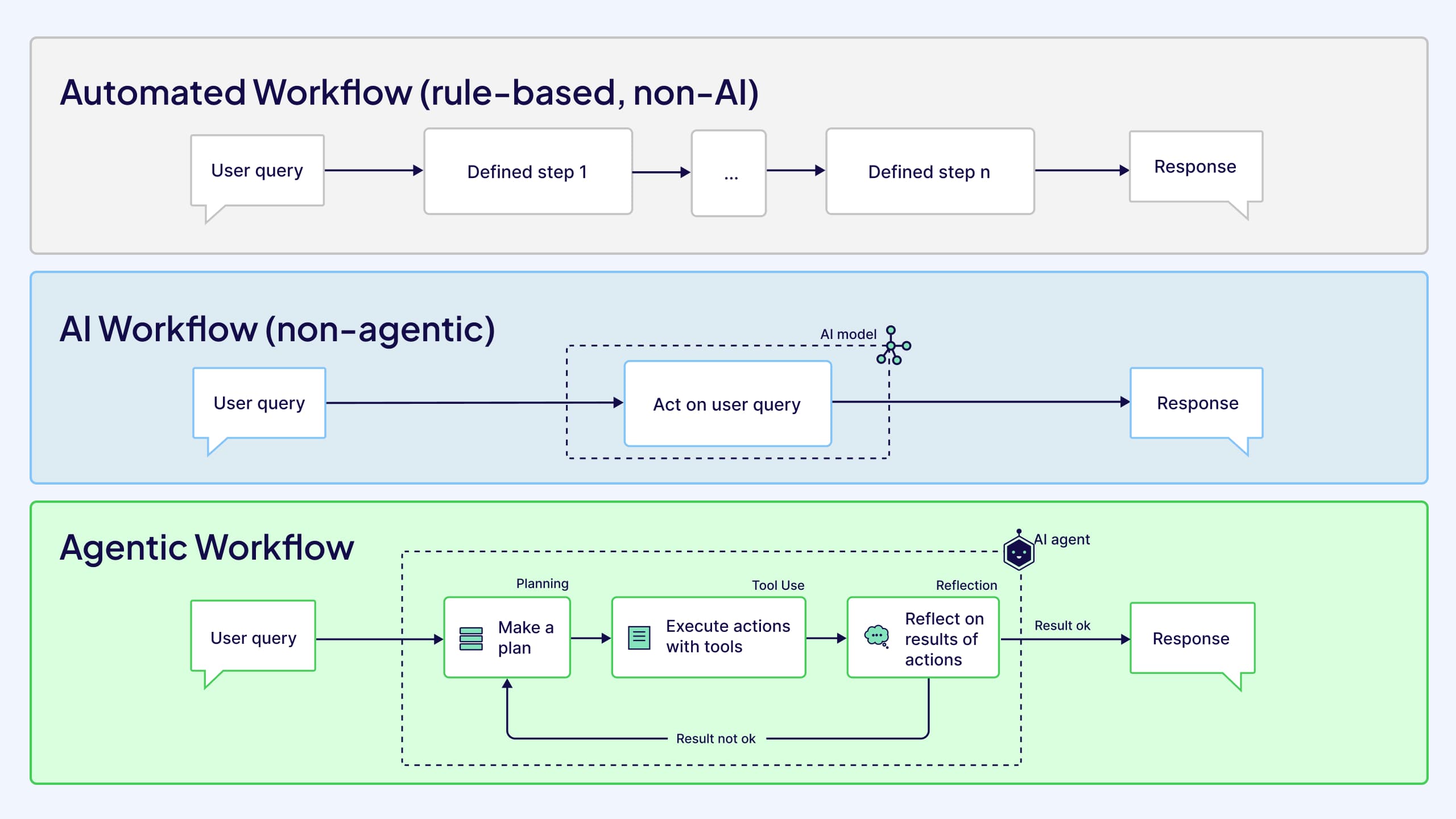
For decades, working with geographic data followed a predictable pattern, where analysts opened dashboards, ran queries, and interpreted maps in a reactive process. A human would ask a question, the system would return a result, and the human would decide what to do next. In this model, the system remains idle until a user starts a specific command, and the analyst handles every step of the workflow, including selecting datasets, running spatial operations, exporting results, and interpreting outputs. Even when machine learning models are used, the workflow is still led by the user, who controls the sequence of tasks and connects the data to decisions.
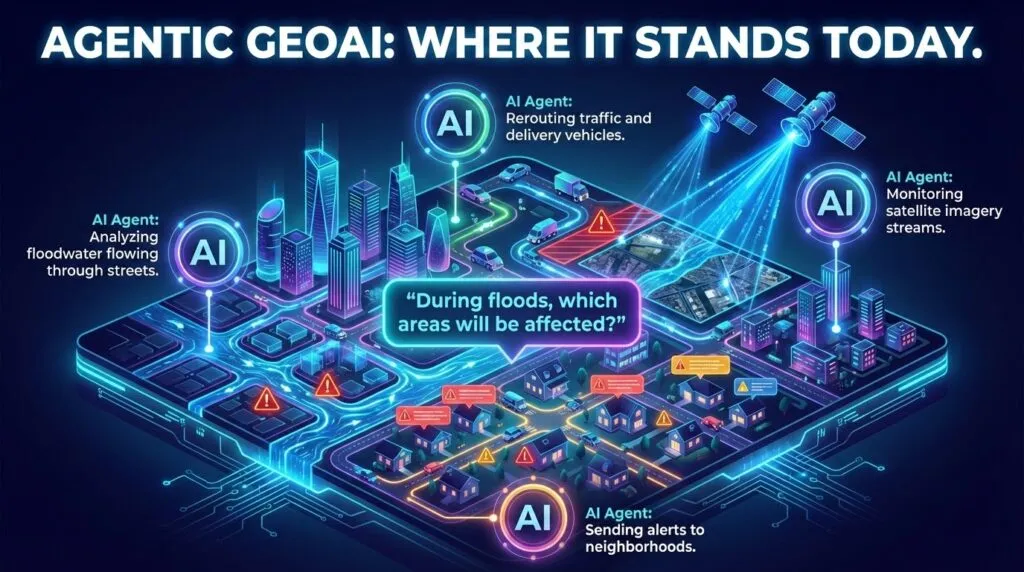
That model is now breaking down. Instead of managing individual steps, users define goals. An AI system receives a mission such as optimizing evacuation routes during a flood or monitoring infrastructure risks across a region. The system then plans the workflow itself, retrieving data, running spatial tools, and producing results autonomously.
Agentic AI is beginning to appear across many industries. Enterprise deployments show how autonomous agents can significantly reduce the time employees spend retrieving and processing information. Similar trends are discussed in research on agentic artificial intelligence and its economic applications, where AI systems manage complex workflows with minimal human supervision.
In geospatial systems, this change carries important implications. Maps are no longer just tools for viewing information. They can become active systems that observe changes, run analyses, and coordinate decisions.
This article explores how agentic systems are redefining GeoAI workflows. It examines the move from dashboards to autonomous spatial agents, the role of geospatial reasoning in enabling agency, and the tools that allow agents to interact with real geospatial infrastructure. It also discusses the rise of multi-agent coordination and why human supervision remains essential as these systems become more autonomous.
Source: Weaviate
From Dashboard to Autonomy
Traditional GIS workflows are built around step-by-step interaction. Analysts retrieve datasets, run spatial tools, and interpret results manually. Even advanced GeoAI models usually operate within this structure. The system produces outputs, but humans still manage the process.
Agentic systems change this relationship. Instead of controlling each step, users describe the goal, and the system organizes the workflow needed to achieve it.
For example, consider a flood response scenario. A traditional workflow might require analysts to download rainfall forecasts, update hydrological models, request satellite imagery, and manually produce evacuation maps. The agentic system can automate these steps. It monitors incoming data streams, retrieves updated imagery, runs simulations, and produces route recommendations automatically.
This type of autonomous workflow is becoming more feasible as AI systems learn to plan tasks and coordinate multiple tools. Technical discussions of autonomous AI systems and agentic architectures describe how complex goals can be decomposed into smaller actions that agents execute sequentially.
Geospatial agencies are beginning to explore these capabilities as well. The GeoAI in Focus report from the Pennsylvania GeoBoard highlights how automated spatial systems can support infrastructure monitoring, disaster management, and environmental analysis.
From Reasoning to Agency
Autonomous geospatial systems require more than pattern recognition. They must understand how spatial systems behave.
This capability is often described as geospatial reasoning. It allows AI systems to interpret relationships between geographic features and to respect physical constraints. Roads connect networks, water flows downhill, and infrastructure interacts with terrain. Without this understanding, automated systems may generate results that are mathematically correct but physically impossible.
The agency builds on this reasoning ability. If reasoning is the system’s understanding of spatial relationships, the agency is its ability to act on that understanding.
Models for grounded spatial reasoning (like Spatial-Agent) show how AI systems can incorporate geographic rules directly into their decision processes. Instead of simply predicting patterns, these systems evaluate whether spatial outcomes are physically plausible.
Three-dimensional spatial data can also improve this reasoning ability. The LOD1 3D city models and urban spatial intelligence provide much richer information for navigation, infrastructure planning, and environmental modeling than traditional two-dimensional maps.
Large research organizations are also exploring how AI agents can simulate possible future scenarios. Microsoft’s research agenda on trusted agents and simulation-based reasoning describes systems that evaluate how cities and infrastructure may change over time rather than simply analyzing current data.
Together, these developments move GeoAI from a system that analyzes spatial patterns to one that can plan actions within spatial environments.
The Tool-Use Revolution in GIS
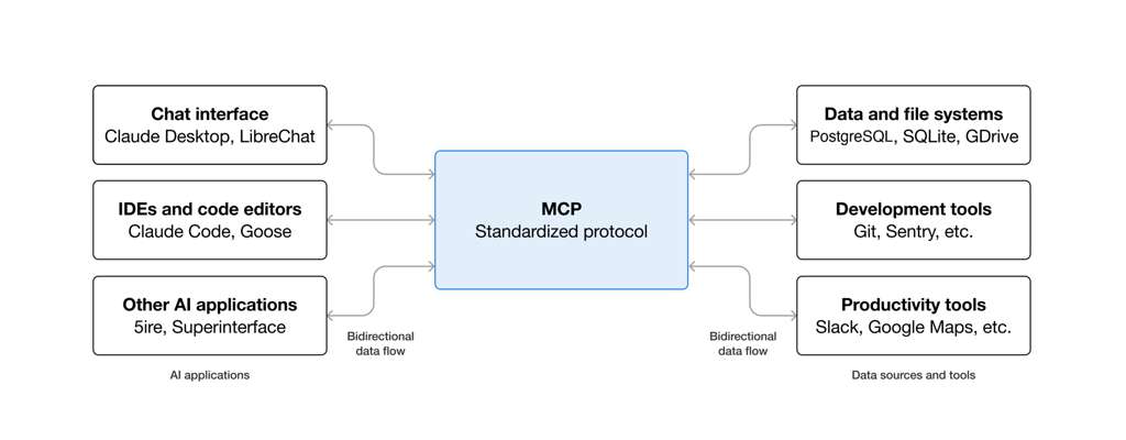
For geospatial agents to act autonomously, they must be able to use the same tools that human analysts rely on. In traditional GIS environments, spatial analysis depends on manual interaction with software: running buffers, querying datasets, requesting satellite imagery, or executing Python scripts. Each step requires a person to trigger the next operation.
Agentic systems treat these tools differently. Instead of waiting for human input, the system identifies which tool is needed and executes it automatically. In effect, geospatial APIs and software libraries become the “hands” of the agent, allowing it to interact with spatial data and infrastructure directly.
Consider a scenario where a monitoring system detects unusual activity in satellite imagery. A traditional workflow would require an analyst to inspect the image and manually request higher-resolution data. An agentic system could recognize the uncertainty itself and automatically order a higher-resolution image from a satellite provider. The system is no longer just interpreting data. It is actively collecting the information it needs.
This capability is becoming possible as geospatial tools are redesigned for machine interaction. Frameworks such as GIS-MCP, which allow AI systems to interact with geospatial Python libraries, enable agents to execute operations in GeoPandas or Shapely through natural language commands rather than manual scripting.
Source: Skywork.ai
Satellite infrastructure is evolving in the same direction. Platforms like Vantor’s unified satellite tasking API allow a single system to communicate with multiple satellite constellations without needing separate integrations for each provider. This simplifies the process of retrieving imagery when agents need updated observations.
On-demand satellite intelligence platform services push this idea further by enabling automated satellite tasking directly through AI systems. These capabilities are already attracting attention in defense and security environments. Together, these developments transform GIS software from a static toolkit into an interactive environment that autonomous agents can operate within.
Multi-Agent Spatial Orchestration
Many geospatial problems involve complex interactions between environmental, infrastructural, and social systems. Flood prediction, urban resilience planning, and climate adaptation all require multiple models and data sources working together. A single AI system often cannot manage this complexity alone.
This is where multi-agent systems become important. Instead of one general model performing every task, multiple specialized agents collaborate to solve different parts of the problem. They are often defined as collections of autonomous entities that make independent decisions while coordinating toward shared goals, as seen in domains such as autonomous vehicle coordination and smart grid management.
Current geospatial systems are not yet fully multi-agent. They typically operate as centralized workflows composed of analytical components rather than independent, decision-making agents. However, they still highlight the need for coordination across models, data sources, and tasks that multi-agent approaches are designed to address.
For these agents to collaborate effectively, they need a shared representation of the environment. Spatial knowledge graphs provide one such structure. In these graphs, geographic features such as roads, bridges, buildings, and weather systems are connected through relationships that allow agents to reason about dependencies and impacts.
Context-aware retrieval systems built on spatial knowledge graphs combine geographic data with textual information, enabling agents to interpret both maps and documents when solving operational problems. Microsoft Research’s work on agentic AI collaboration systems examines how teams of specialized agents can coordinate tasks and share information when solving complex research problems. Multi-agent architectures are also appearing in engineering environments, where coordinated agents have been shown to significantly accelerate complex design workflows.
In geospatial contexts, these collaborative systems could allow AI to monitor and manage multiple spatial processes simultaneously. Instead of isolated analyses, the future of GeoAI may involve networks of specialized agents coordinating decisions across entire cities or ecosystems.
The Human-in-the-Loop Problem
As geospatial agents become more autonomous, the role of GIS professionals changes. Instead of manually processing data, analysts increasingly act as supervisors of automated systems.
This oversight matters because agentic systems can still make serious spatial errors. One example is geo-hallucination in urban analytics, where AI systems infer roads, bridges, or paths that do not actually exist. To reduce these risks, governance frameworks are becoming essential. The Dual-Helix governance framework for reliable agentic AI in WebGIS development separates the responsibilities of human rule-setters and AI executors so that autonomy does not become uncontrolled action.
Major GIS platforms are already moving in this direction. New AI assistants in ArcGIS environments introduced in February 2026 include role-based permissions that define what automated systems are allowed to do. Even consumer platforms such as Google Earth’s 2026 roadmap and natural-language search updates still emphasize the need for human validation.
Autonomy changes the role of geospatial experts, but it does not remove them. It makes their judgment more important.
The next stage of GeoAI may transform maps into living systems. Instead of static visualizations, geospatial platforms could function as continuously operating infrastructures that monitor environmental signals, infrastructure conditions, and human activity in real time.
Early signs of this shift already appear in connected work graphs and real-time risk intelligence, where dynamic information networks act as operational command centers. Similar ideas appear in discussions of advancing AI maturity and governance orchestration, where organizations coordinate complex systems through AI-driven decision platforms. Experimental environments for AI-driven discovery and decision intelligence suggest that geospatial intelligence may eventually operate as a continuous background layer supporting planning and monitoring across cities and ecosystems.
If that happens, maps will no longer be something we consult occasionally. They will become active systems that monitor change, anticipate risk, and assist decisions continuously.
GeoAI began as a tool for understanding geographic patterns. With the rise of agentic systems, it may evolve into something far more powerful: a dynamic network of intelligent systems helping manage the planet itself.
Further Resources:
- https://opengeoai.org/examples/AI_agents/
- https://github.com/opengeos/gee-agents
- https://mapsplatform.google.com/ai/
- https://www.youtube.com/watch?v=gwxNOYHOt1E
- https://www.nv5.com/geospatial/solutions/geoai/
- https://www.forbes.com/councils/forbesbusinesscouncil/2025/07/15/geoagentic-ai-unlocking-actionable-geospatial-intelligence/
Did you like this post? Read more and subscribe to our monthly newsletter!


#GeoAI


Next article
Originally, I shared this blog post in 2014 after coming across the English translation of “Map” by Wisława Szymborska in The New Yorker.Reading it again more than a decade later, I felt compelled to reshare it. Because in a world now shaped by satellite imagery, AI-driven mapping, and digital twins, this poem feels even more relevant.
Despite all the technology, something hasn’t changed. We still look at maps with the same quiet fascination. The same sense of control. The same illusion that the world can be understood at a glance.
A map doesn’t move. It doesn’t resist. It doesn’t overwhelm. It waits.
In a profession built on data, precision, and increasingly—automation—Szymborska reminds us of something softer, almost uncomfortable… That what we love about maps is not accuracy. It’s the feeling they give us. Calm. Order. Simplicity.
A world where everything is visible, reachable, and somehow… manageable.
And maybe that’s why this poem continues to resonate not just with cartographers, but with anyone trying to make sense of complexity. Before dashboards, before GeoAI, before real-time Earth observation there was this quiet moment…
A person.
A map.
And the illusion that everything fits.
MAP
Wisława Szymborska
Flat as the table
it’s placed on.
Nothing moves beneath it
and it seeks no outlet.
Above—my human breath
creates no stirring air
and leaves its total surface
undisturbed.
Its plains, valleys are always green,
uplands, mountains are yellow and brown,
while seas, oceans remain a kindly blue
beside the tattered shores.
Everything here is small, near, accessible.
I can press volcanoes with my fingertip,
stroke the poles without thick mittens,
I can with a single glance
encompass every desert
with the river lying just beside it.
A few trees stand for ancient forests,
you couldn’t lose your way among them.
In the east and west,
above and below the equator—
quiet like pins dropping,
and in every black pinprick
people keep on living.
Mass graves and sudden ruins
are out of the picture.
Nations’ borders are barely visible
as if they wavered—to be or not.
I like maps, because they lie.
Because they give no access to the vicious truth.
Because great-heartedly, good-naturedly
they spread before me a world
not of this world.
_
Translated, from the Polish, by Clare Cavanagh
NewYorker April, 14th, 2014
Wiesława Szymborska

